Sectoral marine plan: regional locational guidance
Sets out regional spatial baseline data for the sectoral marine plan for offshore wind energy and describes the information used in the planning and assessment process.
4 North
4.1 Introduction
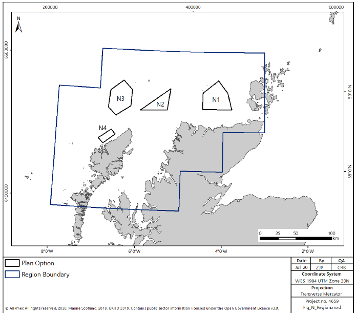
4.1.1 The North region covers the coastal and marine environment extending from the northern extent of the West region (incorporating approximately the northern half of the Outer Hebrides and the northern portion of Skye) around the coastline and including most of the Orkney Islands (Figure 99). There are four Plan Options within the North region, all either to the north of the Outer Hebrides or to the north of the mainland coastline to the west of the Orkney Islands (Figure 99).
4.2 Physical Considerations
Offshore Wind Resource
4.2.1 Within the North region, encompassing four Plan Options (N1, N2, N3 and N4) there is considerable available wind resource, as shown in Figure 100 using the annual wind speed as a proxy, and calculated in Table 3 for the four Plan Options.
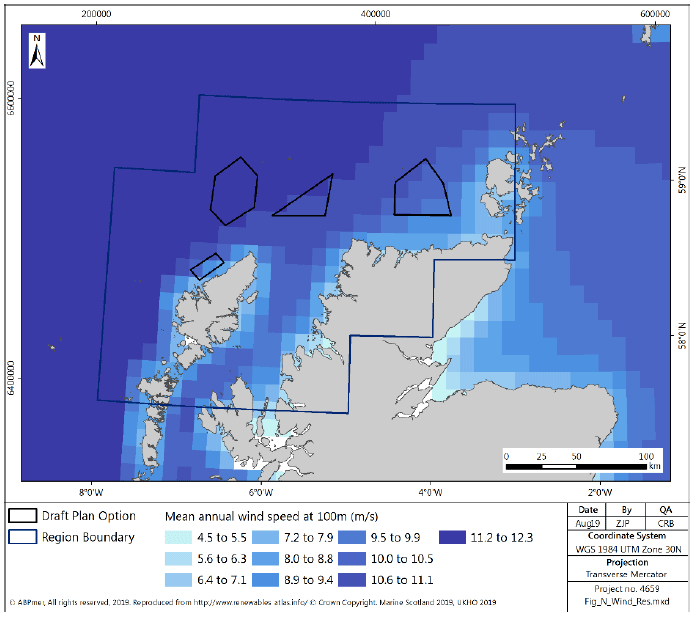
| Area of Search | Region | Area (square km) | Potential Installed capacity (GW) | Realistic Maximum Development Scenario (GW) |
|---|---|---|---|---|
| N1 | North | 1163 | 5.8 | 2 |
| N2 | North | 561 | 2.8 | 2 |
| N3 | North | 1106 | 5.5 | 2 |
| N4 | North | 200 | 1.0 | 1 |
| North Total | 3030 | 15.1 | 7 | |
Grid Connection
4.2.2 The current grid connection provision is limited in the western extent of the North region, with a limited number of 132 kV substations available. In the eastern extent of the region the presence of the Dounreay former nuclear power station means that the infrastructure for large scale grid supply is already present with a 275 kV substation at the coast. In addition, the Caithness-Moray reinforcement project is currently being implemented to increase capacity from the North region, including:
- a 1200MW HVDC link between Spittal in Caithness and Blackhillock in Moray;
- rebuilding the 132 kV double circuit line between Dounreay and Spittal at 275 kV;
- a short section of new 132 kV line between Spittal and Mybster;
- and new 275/132 kV substations at Fyrish (near Alness), Loch Buidhe (to the east of Shin), Spittal (5km north of Mybster) and Thurso.
4.2.3 The proposed Western Isles 600MW HVDC interconnector, should it be consented and progress, will increase the potential for connection of renewables on the Isle of Lewis for supply to the mainland. A needs case has been submitted to support the Western Isles HVDC and progress on the project is expected to be reliant on the developments awarded at the next Contracts for Difference issue in 2019. The Western Isles HVDC is discussed in greater detail below in Section 4.3.
Bathymetry and Seabed
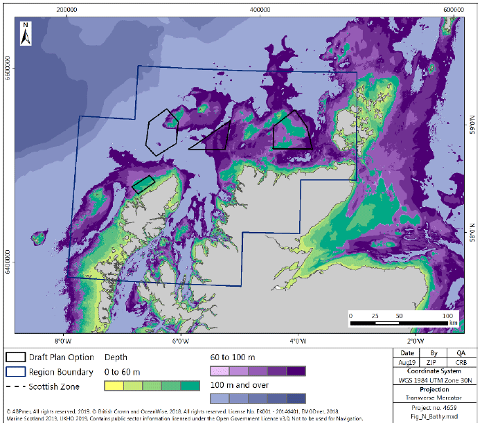
4.2.4 Within the North region the water depth generally shelves rapidly to greater than 60 m, as shown in Figure 101. This is reflected in the water depths in the Plan Options, which are generally greater than 60 m. The exceptions are N4, an area within the western portion of N1 and small areas at the north-eastern extent of N3.
4.2.5 Large extents of the Plan Options are in water less than 100 m deep, with the majority of N1 and N4 in less than 100 m of water. A proportion of N2 and N3 have water depths greater than 100 m.
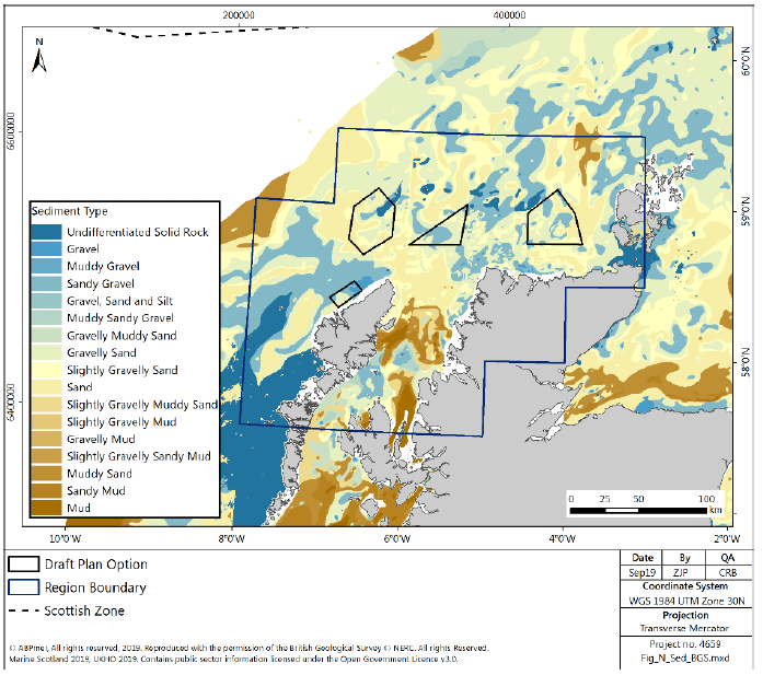
4.2.6 The seabed sediments, shown in Figure 102, are generally composed of sand and gravel throughout the North region, with some areas of rock to the west of the Hebrides and in a small band approximately 50km offshore of the North Scotland coast. Within the Plan Options, the majority of sediment are sand and coarse sediment, with some small areas of subtidal rock or hard substrate in the eastern extents of N3.
4.3 Socio Economics
Supply Chain
4.3.1 Two locations are identified in the North region[209] which could be developed to support the construction, operation and maintenance of offshore wind in the three Plan Options. These are:
- Arnish- distributed manufacturing,
- Kishorn- distributed manufacturing.
4.3.2 There are other sites which, although not identified in the NRIP, could support development in the North region, including Scrabster which has previously been used to transfer components for onshore wind and projects are ongoing to increase capacity of ports in the North region to support offshore wind including at Stromness, Lyness and in Scapa Flow where there are proposals for a new deep water quay.
4.3.3 Arnish is on the East coast of the Isle of Lewis, and is currently mothballed as a site, with a small retained skeleton of employees. Previously employing 1400 people at its peak the local workforce retains the skills to restart manufacturing at the site which has supported the renewables industry, including manufacturing processes supporting the Beatrice windfarm[210]. As part of the port masterplan for Stornoway, it identifies that the expansion of the port, including the development of a deep-water port facility, has the potential to support expansion of offshore wind farm component manufacturing at Arnish[211].
4.3.4 Kishorn has been identified as a key site for the expansion of the renewables industry, including in manufacture of concrete bases for turbine foundations. The site has planning permission in place, in line with its port master plan, to expand the quarry and facilities including offices, accommodation and engineering and fabrication sheds, alongside the applicable marine licences for deep water berthing and anchoring of floating structures in Loch Kishorn[212]. Kishorn is well placed to support floating offshore wind, having prepared its infrastructure to potentially support the Kincardine development.
4.3.5 In addition to the above, there are potential socio-economic benefits from developing supply chains to support offshore wind, particularly through the development of onshore operations and maintenance support.
Energy Generation
4.3.6 There are two power stations located within the North region. Both are diesel power stations, one in Stornoway on the Isle of Lewis, the other in Kirkwall, Orkney.
4.3.7 There is one consented demonstration wind energy development in the North region, the Dounreay Tri development, for two 5MW wind turbine generators (Figure 103).
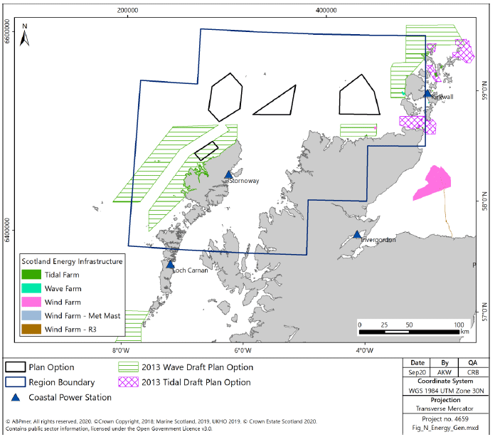
4.3.8 Tidal stream energy and wave energy generation is currently being developed within the North region and there are facilities currently operational or under development in the coastal seas around the Orkney Islands (Figure 103). In particular, there is a tidal stream energy array operational and looking to expand within Pentland Firth. None of the current developments, or areas with Crown Estate Scotland lease areas directly overlap with the Plan Options for offshore wind.
4.3.9 In 2013 the Marine Scotland consulted on Draft Plan Options (DPO) for wave and tidal energy[213,214]. These draft options were subsequently recognised in Scotland’s National Marine Plan[215]. The DPOs identify areas of potential for the future development of wave and tidal energy in Scottish waters (Figure 103). The plan options for wave energy overlap with the N4.
Power Interconnectors
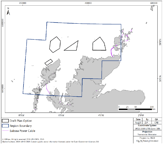
4.3.10 There are 210km of power interconnectors in the North region connecting the Isle of Skye to the Outer Hebrides and the Orkney Islands and shorter connections to link other small islands in the region. All the power interconnectors are inshore of the Plan Options. (Figure 104).
4.3.11 There is a High Voltage Direct Current (HVDC) link in the early stages of development between the island of Lewis and the Scottish mainland. The Western Isles Connection will be used to transmit electricity generated by renewable developments on the Western Isles to areas of demand around towns and cities on the mainland. The project requires an HVDC Converter and substation at Arnish Point, Stornoway, an HVDC Converter and substation within the existing Beauly Substation, an HVDC underground cable between Beauly Substation and Dundonnell, on the west coast and an HVDC subsea cable between Arnish Point and the land fall at Dundonnell[216].
4.3.12 In addition, there is the potential for an interconnector project between Scotland and Iceland (‘Ice Link’), which is currently in the feasibility stage.
Telecom Cables
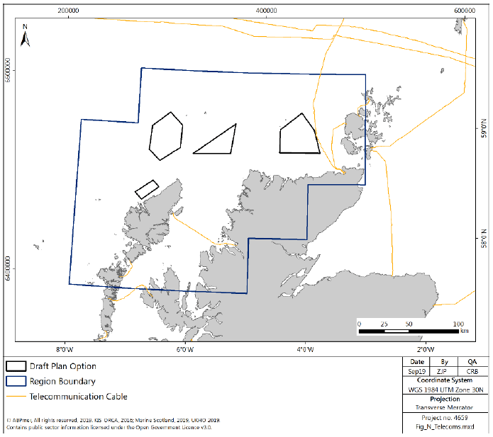
4.3.13 The North region has 337km of active telecom cables. These mostly travel north and south of Orkney and Shetland connecting Europe to North America, Faroe Islands, Iceland and Greenland, a length of which is close to the eastern boundary of N1. There are a few short sections of cables inshore of the Plan Options, connecting the Outer Hebrides and Orkney to the mainland, but the majority are further out to sea (Figure 105).
Carbon Capture and Storage
4.3.14 There are currently no identified potential CCS storage areas within the North region on the west or north coasts of Scotland. All potential saline aquifers, and the majority of oil and gas infrastructure, are off the east coast.
Oil and Gas
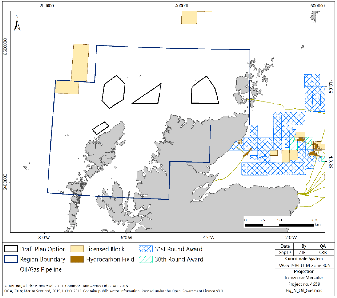
4.3.15 There are very few oil and gas related activities currently taking place within this Region. To the west of N3 there is one licensed block (Figure 106). It is not anticipated that there will be any significant exploration or development activity in the region in the foreseeable future.
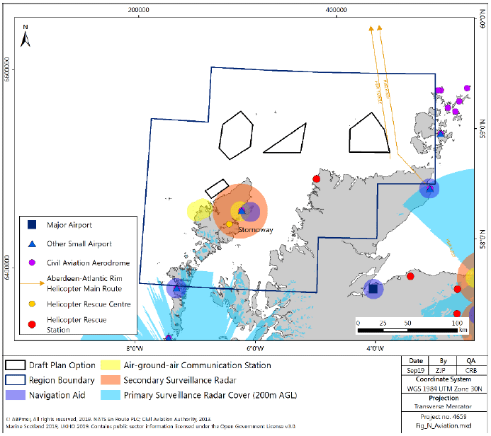
Aviation
4.3.16 There are no major airports in the North region. Airports in this region include civil aviation aerodromes at Benbecula and Stornoway and a helicopter rescue station (Figure 107).
4.3.17 Benbecula is a hub for the Southern Isles and provides flights between North and South Uist[217]. Stornoway airport is the main air link to the Isle of Lewis.
4.3.18 There is secondary surveillance radar used at Stornoway airport, but it does not overlap with any of the proposed Plan Options (albeit it is very close to the boundary of N4).
4.3.19 Both Benbecula and Stornoway airport are safeguarded civil aerodromes.
Defence
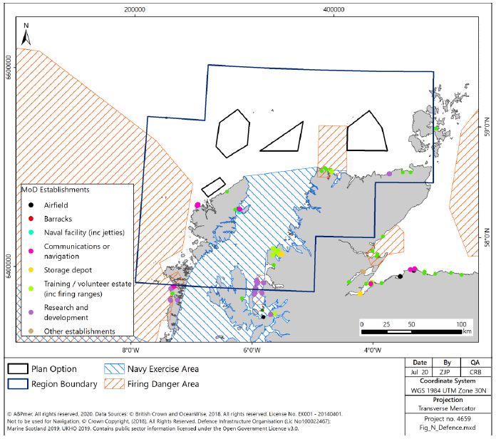
4.3.20 As identified in Figure 108, there is a considerable amount of defence related activity in the North region, particularly in the seas around the Hebrides, where to the east lies a Naval exercise area and to the west a firing danger area. To the north of the north-western corner of Scotland there is an additional firing danger area, which falls between N1 and N2.
4.3.21 There is likely to be limited employment associated with defence activities within the North region (regional breakdowns of MOD employment are not available within Scotland) when considered against national scale employment, however it has been identified in the past that even a small change to the level of defence employment has the potential to impact on small island or remote economies where it may be the largest employer[218].
Fishing
4.3.22 Landings from UK-registered vessels caught in the North region had an average annual value of £362 million and an average live weight of 64,955,157 tonnes for the five year period 2013-2017.
4.3.23 The majority of landings were of pelagic species (60%), and the majority of all landings were taken by the over 12 m fleet (93%). The dominant gear type was midwater trawls (57%) although demersal trawls (24%) and creeling (14%) also made significant contributions.
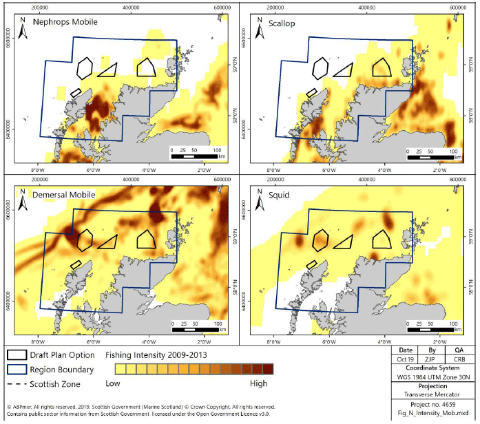
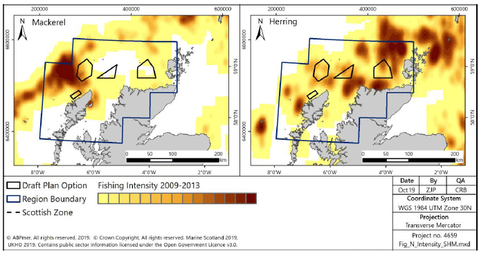
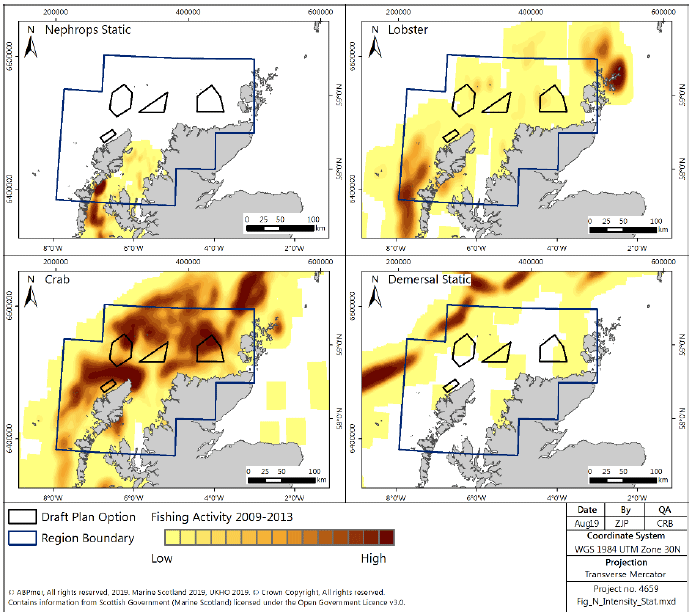
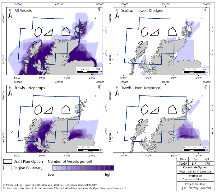
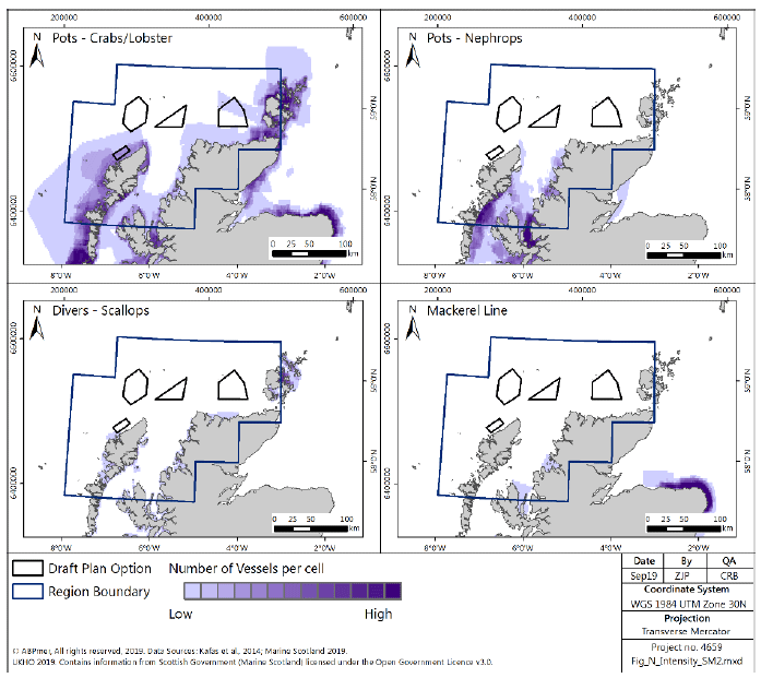
4.3.24 Figure 109 shows over-15m Nephrops trawls operate predominantly in The Minch, with scallop dredgers operating between Skye and Lewis. Demersal mobile gears targeting demersal fish operate further north and west along the shelf edge, and to the north-west of Orkney. Fishing for herring by over-15m pelagic vessels is patchy across the region, and particularly concentrated around the north coast of Scotland, north-east and north-west of Orkney, whereas fishing for mackerel takes place further offshore along the shelf edge and in the vicinity of Plan Option N3 (Figure 110). Over-15m vessels operating static gears fish across the region, particularly for crab, whereas Nephrops creels are more restricted to The Minch and the east coast of Lewis and North Uist, lobster creels are used particularly around Orkney and west of the Outer Hebrides (Figure 111).
4.3.25 Areas important for under-15m vessels are The Minch, Inner Sound and around Orkney (Figure 112). Under-15m vessels fishing in The Minch are predominantly Nephrops trawlers (Figure 112), with important creeling areas (for Nephrops, crabs and lobsters) around Orkney, Dunnet Head on the north coast of the mainland, North Uist, and Inner Sound (Figure 113).
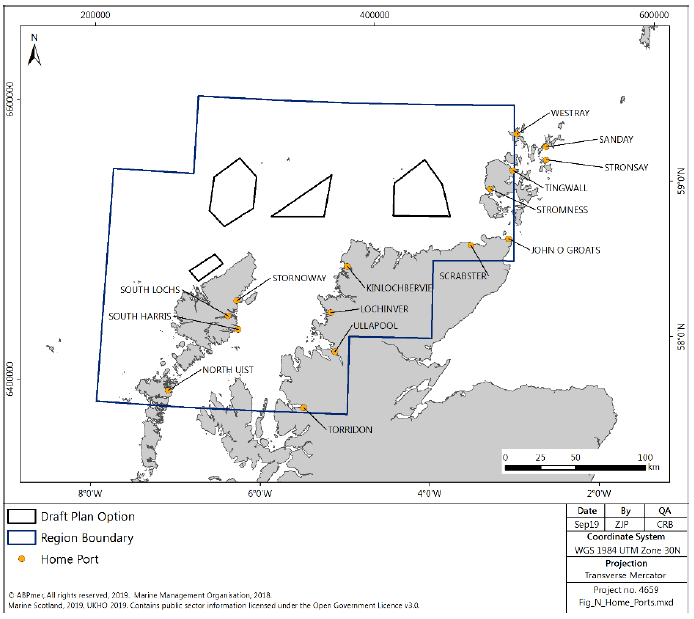
4.3.26 There were 385 fishing vessels with their Home Port registered within the North region in 2016[219]. The majority (76%) of these were in the ten metres and under length category. The ports with the most registered vessels were Ullapool (86), Stornoway (85), Scrabster (52), Lochinver (26) and Westray (16). The highest number of over-15m vessels were registered in Stornoway (17), Lochinver (16) and Ullapool (10). Home ports within the North region are shown in Figure 114.
4.3.27 The main landing ports (in terms of value of landings in 2017) in the North region are Scrabster (£32 million), Ullapool (£15 million) and Kinlochbervie (£15 million)[220].
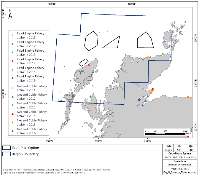
4.3.28 There are five fixed engine sites for wild salmon and sea trout, four along the north coast and one on Skye, and one net and coble site on Stornoway (Figure 115).
4.3.29 The main rod and line fishing rivers in this region are the Rivers Torridon (salmon), Ewe (salmon), Gruinard (salmon), Ullapool (salmon), Kirkaig (salmon), Inver (salmon), Thurso (salmon), Halladale (salmon), Naver (salmon and sea trout), Borgie (salmon), Dionard (salmon and sea trout), Laxford (salmon).[221]
Aquaculture
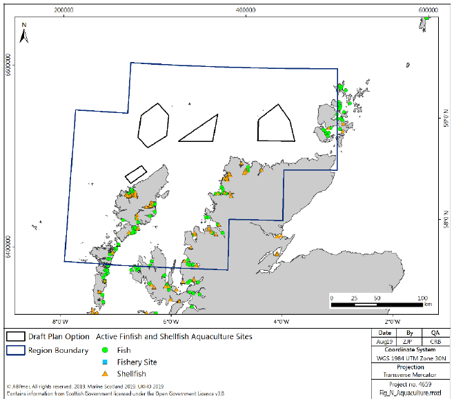
4.3.30 Marine aquaculture sites within the North region are shown in Figure 116. There are 71 licensed finfish and 71 licensed shellfish sites. Aquaculture sites are widespread along the coastline within the North region, with concentrations in the Outer Hebrides and around the Summer Isles.
4.3.31 There are no aquaculture facilities within the Plan Options and it is considered unlikely that development will be brought forward in these areas unless there is beneficial co-location with offshore wind development.
4.3.32 In the North region shellfish production is dominated by mussel and Pacific oyster, although small quantities of scallop, queen scallop and native oyster are also produced. The North region encompasses parts of the Highland, Western Isles and Orkney regions used in the Scottish Government’s 2017 Production Survey, therefore, production numbers will be an over estimation. The aquaculture industry farms high levels of salmon in the North region. In 2016, approximately 94,000 tonnes were produced with a value of £305 million.
4.3.33 In 2017, 954 tonnes of mussels and 1,948 tonnes of Pacific oysters were produced.
Ports and Harbours
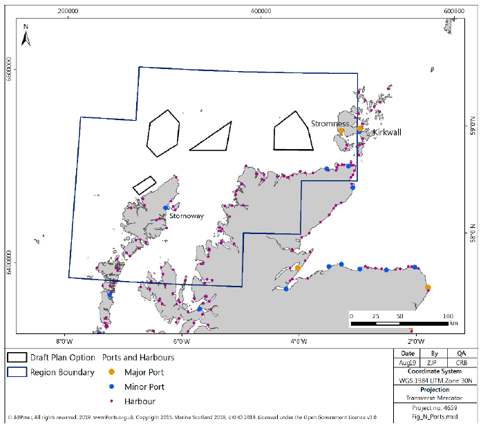
4.3.34 The North region has 1 major port, 3 minor ports and many smaller harbours that provide important facilities, quays and shelter for vessels moving between locations (see Figure 117).
4.3.35 The Orkney Harbour Authority's Port Masterplan was published in June 2019[222] and includes targeted plans to invest in new deepwater port infrastructure which could support offshore wind projects from the Sectoral Marine Plan.
4.3.36 Stromness is the only major port in the North region. It is the base for the daily Northlink Ferry to Scrabster, the MV Graemsay ferry to Hoy and Graemsay, the base for the local lifeboat, and is a popular destination for smaller cruise liners[223].
4.3.37 Kirkwall port is the main hub for the interisland ferry routes, fishing and dive vessels[224].
4.3.38 Lyness is the port for the ferry from the Mainland to Hoy. It is also a key economic investment area, identified to support assembly, storage and servicing of renewable energy devices. A development brief has been prepared to guide the planning and investment around Lyness Harbour and the wider peninsula. Improvements will be made to the moorings; new buildings are planned, and extensive areas of hard standing will be laid[225].
4.3.39 On the mainland Scrabster is a key port and hub of economic activity in the region, catering for sectors including oil and gas, renewables, fishing and cruise ships[226]. It has also has been identified for further consideration in Phase 2 of the NRIP. Its location on the Pentland Firth is focusing plans for improvement and investment to support the wave and tidal renewables sectors. Redevelopment is ongoing, and Scrabster Harbour's St Ola Pier Redevelopment received a marine licence in February 2020. Wick has also been identified as a key potential location to support wave and tidal related activities in Phase 2 of NRIP.
4.3.40 John O’Groats provides a ferry service to and from Orkney (Burwick) and a second service is provided from Gills Bay to and from Orkney (St Margaret’s Hope).
4.3.41 There is a high concentration of anchorages in the North region, particularly in the Outer Hebrides and Orkney, reflecting the high sailing activity in the area. None of the anchorages overlap with the Plan Options.
4.3.42 There are a few dredge disposal sites in the region. They are all close inshore and do not overlap with the Plan Options.
Shipping
4.3.43 Key routes through the North region include passage through the Minches, the recommended deep-water route to the west of the Outer Hebrides, transit routes around the north coast, through Pentland Firth and to the north of the Orkney Islands towards Shetland, and ferry routes between the mainland and the Outer Hebrides, Skye and the mainland.
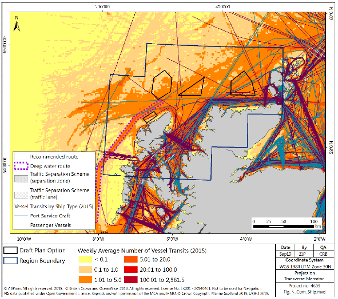
4.3.44 AIS density data (Figure 118) shows areas of high shipping density (up to 100 vessel transits per week) in the Minches, including transit through the area (incorporating the TSS scheme just to the south of the North region) and ferry services.
4.3.45 There are two key areas for lifeline ferry services in the North region, one connecting North and South Uist with Skye and the mainland, principally at Ullapool, and the other across Pentland Firth to the Orkney Islands, within the Orkney Islands and further towards Shetland. Both areas are represented by clear lines of high shipping density on Figure 118.
4.3.46 The areas of highest density, particularly across the north coast, are inshore of the Plan Options, although there is a route which heads towards Shetland from the north-west tip of the mainland which intersects N1.
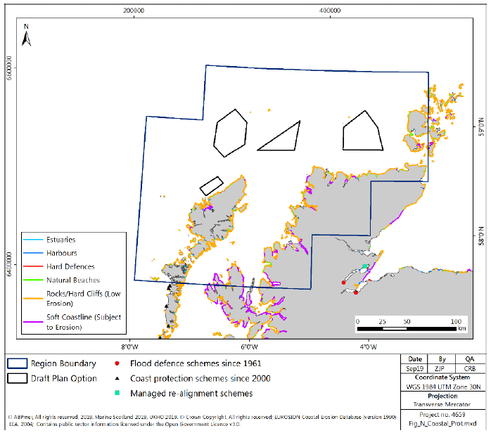
Coastal and Flood Protection
4.3.47 There are few flood prevention works within the North region, with the only coastal protection schemes constructed since 1961 in the far south-western corner of the region (Figure 119), on the Outer Hebrides, approximately 100km south of the nearest Plan Option N4. There are also some small areas of hard defences on the on the Orkney Islands associated with Stromness harbour and other harbour areas throughout the region.
Marine and Coastal Recreation
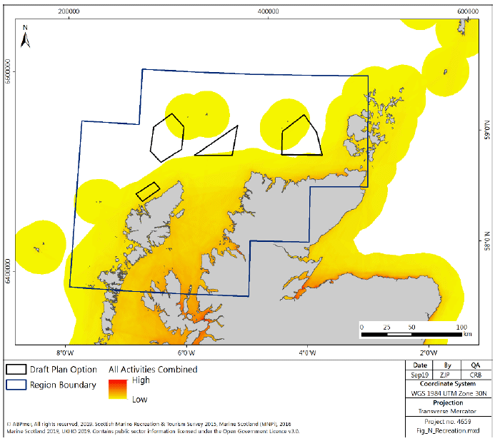
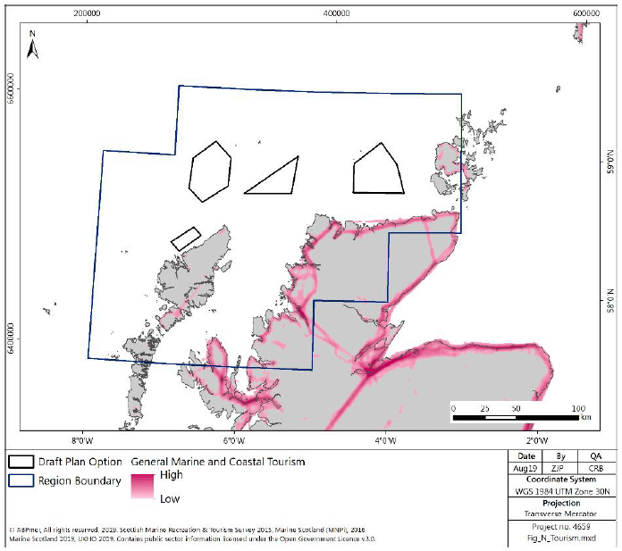
4.3.48 Most recreational activity occurs inshore of the Plan Options (Figure 120), although there is some potential interaction with sailing and cruising routes in the region. Low levels of recreational activity are reported to occur between and overlapping with either all or some parts of each of the Plan Options.
Boating
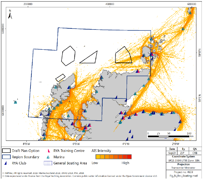
4.3.49 The North region offers uncrowded sailing destinations. Sailing activity is mostly concentrated around Orkney and the sea lochs and islets near the mainland. Heavy recreational use is made of the Summer Isles, Enard Bay, Eddrachalis Bay and the sound of Raasay. However, there is a low to medium level density of recreational boating overlapping with N1 from recreational vessels transiting from the Minches towards Orkney; the majority of the other Plan Options are characterised by no or low levels of reported boating activity.
Angling
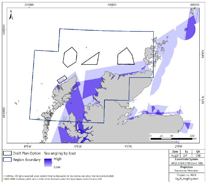
4.3.50 The North region is an unspoilt area and has a wide range of fishing opportunities including some of the best salmon and trout rivers and lochs in Scotland. It also has a varied coastline which offers many good locations for sea anglers. Ullapool is the main sea angling site. It is possible to cast from the shore and catch pollack, haddock, mackerel and skate. Boat fishing trips are also popular (Figure 122). Caithness offers good fishing where bass and flounders are commonly caught from the beach and skate and halibut are sought by boat anglers[227]. Overall, there is little interaction between angling activities and the Plan Options, with the exception of N4, which is considered to overlap with low levels of reported angling activities.
Diving
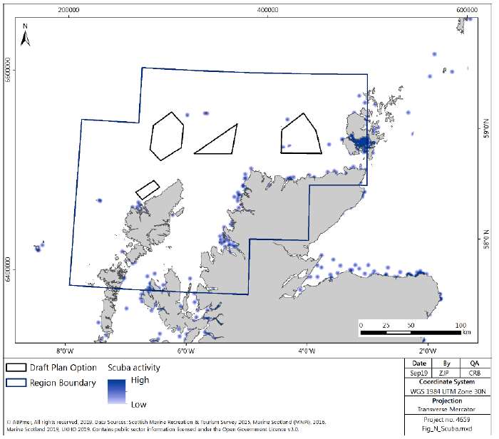
4.3.51 Diving is a popular recreational activity in the North region, with a variety of dive locations. The most popular area for scuba diving in the region is around Scapa Flow in Orkney (Figure 123). This body of water is considered one of the finest wreck diving sites in Europe and has ranked among the top ten wreck diving areas in the world[228]. While scuba diving has predominantly been based in Scapa Flow it is increasingly spreading to other parts of Orkney. Recreational diving is predominantly charter boat based. The only Plan Option that overlaps with reported diving sites is N1, whereby low intensity dive sites are located within but towards the edge of the Plan Option.
Sea Kayaking and Canoeing
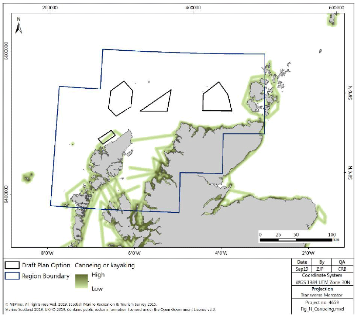
4.3.52 The majority of trips are close inshore (Figure 124). Kayaking and canoeing takes place at most spots along the north coast where there are suitable launching spots such as beaches and slipways. Overall, there is little interaction between sea kayaking and canoeing activities and the Plan Options, with the exception of N4, which is considered to overlap with low-levels of reported sea kayaking and canoeing activities.
Surfing and Windsurfing
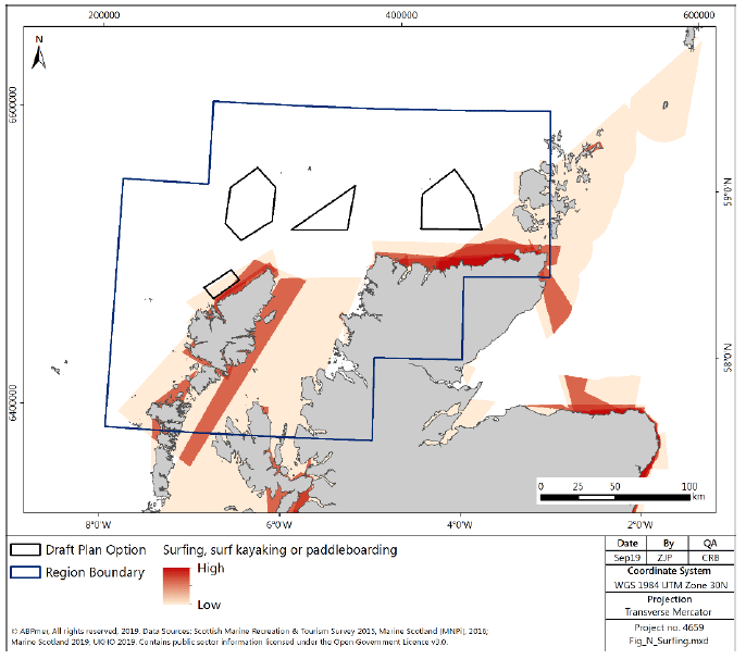
4.3.53 The North region provides high quality surf opportunities, of medium consistency and mostly uncrowded. It receives long-period swell from the North Atlantic and North Sea. The best locations are mainly reef breaks, some of which are world class, however there are a wide variety of surfing locations along the north coast (Figure 125). The prevailing winds in the region are south-westerlies, so offshore at most spots[229]. Overall, there is little interaction between surfing activities and the Plan Options, with the exception of N4, which is associated with moderate to high levels of reported surfing inland of the Plan Option.
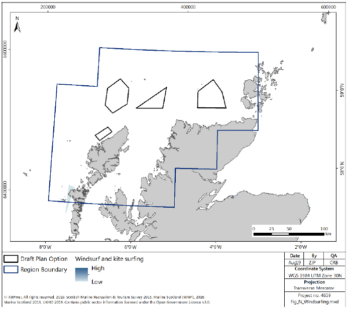
4.3.54 There is very little windsurfing activity in the North region, with small amounts of activity of the Isle of Lewis (Figure 126). Available data show that no windsurfing activity is conducted in any of the Plan Options in the North Region.
Tourism
4.3.55 Tourist sites in the North region include a range of attractions, with a considerable concentration on Orkney (Figure 127).
4.3.56 The Orkney Islands have a rich history, beautiful scenery and abundant wildlife that attract large amounts of tourists every year. Tourism is a major contributor to local economies in the Orkney Islands and the top attractions are St Magnus Cathedral, Skara Brae and Skaill House[230].
4.3.57 In 2017, 65% of visitors went to Orkney for leisure and 19% for business. The profile of visitors was skewed to males (61%) and those over the age of 45 (68%). The number one reason that people chose to visit the area was due to its scenery and landscape (64%), closely followed by its history and culture (62%). The majority of visitors to Orkney were overnight visitors (89%)[231].
4.3.58 The Outer Hebrides and coastal towns in the North region are popular tourist destination in the North region. They offer an assortment of attractions and entertainment alongside a rich history to explore.
4.3.59 In 2017, just over two thirds of visitors went to the Outer Hebrides for leisure and 19% for business. The profile of visitors was skewed to males (58%) and those over the age of 45 (64%). The number one reason that people chose to visit the area was due to its scenery and landscape (71%), closely followed by having always wanted to visit (49%) and to get away from it all (36%)[232].
Social Considerations
4.3.60 The Highland, Eilean Siar (Western Isles) and Orkney Islands Council areas have been used to obtain approximate values for the North region. The total population of the North region is approximately 359,000. The average age in the region is 47, which is 6 years greater than the national average of 41 years old. Roughly 17% of the population is under 16 years old, 60% are of working age and 23% of pension age[233].
4.3.61 In 2017 the employment rate in Orkney was 88.3%, it was lower at 81% in both Eilean Siar and Highlands Council Areas.
4.3.62 The greatest number of jobs in the North region are associated with public admin, education and health (31%). Other important industry sectors are distribution, hotels and restaurants (22%), manufacturing (6%), banking, finance and insurance (6%) and agriculture and fishing (5%)[234].
4.3.63 The Scottish Index of Multiple Deprivation (SIMD) shows that Orkney is in the 5% most access deprived areas in Scotland[235].
4.4 Environment
Designated Sites
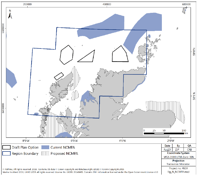
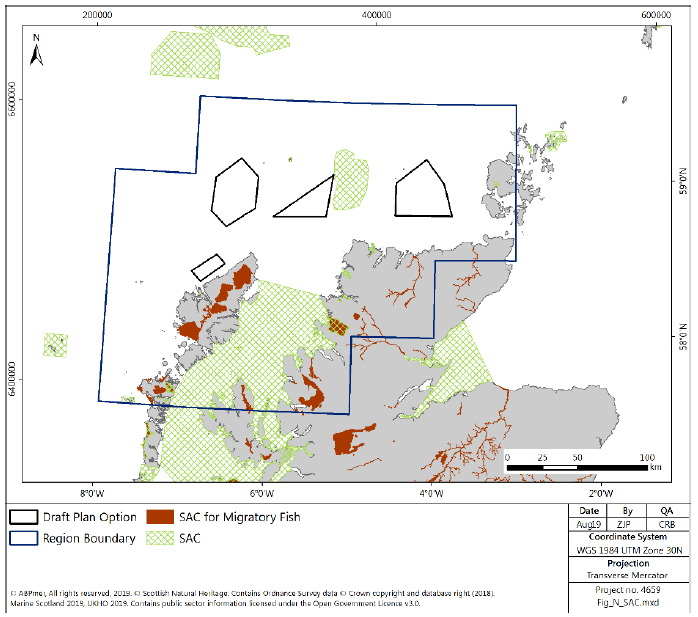
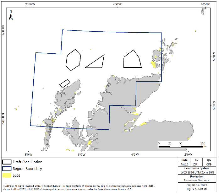
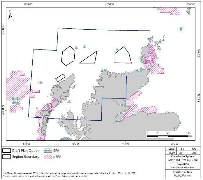
4.4.1 There are a significant number of designated sites, both coastal and further offshore, within the North region. The sites, including 9 NCMPAs (including 3 pNCMPA), 24 SPAs (including 5 pSPAs), 15 SACs and 38 SSSIs are designated for a variety of features, including habitat and more mobile features.
4.4.2 There is no overlap between any designated site and the Plan Options (Figure 128).
4.4.3 There are, however, areas where the Plan Options share a boundary with a designated site. N2 shares part of the eastern boundary with the Solan Bank Reef SAC (Figure 129), designated for reef features and including marine mammals. The Inner Hebrides and the Minches cSAC, designated for harbour porpoise encompasses the area between the Isle of Lewis and mainland Scotland (Figure 129). Any export cabling associated with development in the Plan Options (such as from N2 or N3), depending on routing and likely points of landfall, may intersect the cSAC. There are additional smaller SACs around the sea lochs and within riverine environments in the North region designated for a range of features, including seals, marine mammals, intertidal habitat, reef habitat and migratory fish species.
4.4.4 SPAs and pSPA within the North region support a wide range of birds, both seabird and terrestrial species, some of which may use the sea within the Plan Options for feeding or during migration. There is a high concentration of current and proposed SPA around the Orkney islands in the east of the region. Further detail on seabird species distributions is contained within the Birds section below. There is no direct overlap between the Plan Options and SPA, however, Sule Skerry and Sule Stack SPA is situated on the north-west border of N1. In addition, N3 is located close to, but not neighbouring North Rona and Sula Sgeir SPA and may be used for foraging. The Cape Wrath SPA is approximately 15km from the south-eastern corner of N2 (Figure 131).
4.4.5 The proposed NCMPA North East Lewis, proposed for designation for Risso’s dolphin, sandeels, marine geomorphology of the Scottish shelf seabed and quaternary of Scotland, falls between N2 and the Isle of Lewis. There is therefore potential for cable routes to intersect the designated area if the connection to grid is routed via the Isle of Lewis for OWF development in the Plan Option.
4.4.6 The 16 SSSI (Figure 130) are located across the North region and are protected for a range of features, including geology, habitats and species. Some, although not all, SSSI overlap with European SPA or SAC designations. Although none of the Plan Options overlap with the SSSIs, N1, N2 and N3 are situated close to two SSSIs, including North Rona and Sula Sgeir (close to N2 and N3) and Hoy (close to N1).
4.4.7 In addition to the sites identified within the boundaries of the North region, there may be more remote designated sites which may have the potential to be affected by offshore wind development within the Plan Options. This would be considered on a project by project basis.
Water Quality
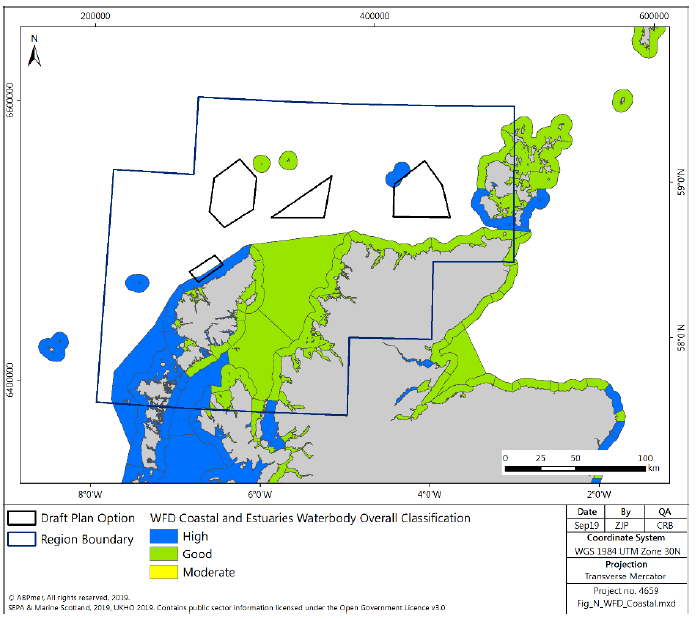
4.4.8 WFD monitoring incorporates coastal and transitional waters in the marine environment. This means that there is only two Plan Options that overlap with classified water bodies in the North region, N4, which overlaps with the Gallan Head to Butt of Lewis water body (high quality status in 2017) and N1 which overlaps with the Sule Skerry and Sule Stack water body (high quality status in 2017). (Figure 132). All the coastal water bodies in the North region are classified as either good or high status[236].
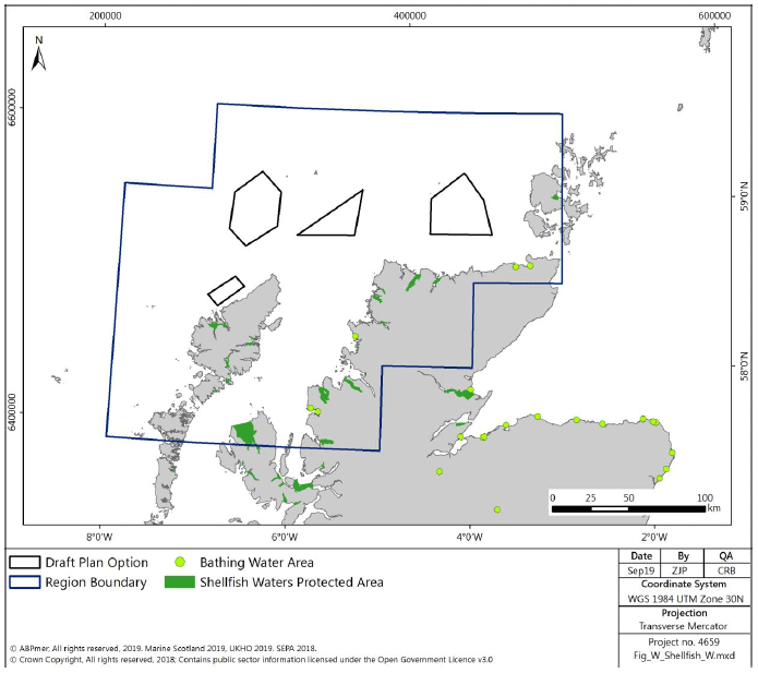
4.4.9 There are areas of protected waters for shellfish production in the North region (Figure 133), mostly within coastal regions associated with either mainland Scotland or the Hebridean islands with no direct interaction with the Plan Options. The shellfish waters are classified against their target objectives, of the 18 shellfish waters in the North region, 10 are classified as not at target objective, the remainder are at target objectives.
4.4.10 There are few classified bathing waters in the North region (five in total) (Figure 133), with three on the west coast (all at excellent status) and two on the north coast of the Scottish mainland. Of the two designated bathing waters on the north coast, one (Dunnet) is at excellent status, whilst the other (Thurso) is currently classed as at target objective.
Benthic Habitats and Species
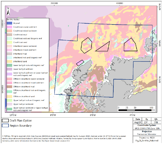
4.4.11 Benthic habitats within the North region compose areas of sand and gravel, with some areas of rocky substrate to the west of the Hebrides, in a small band approximately 50km offshore of the north Scotland coastline and to the south of the Orkney Islands (discussed above in Section 4.2). As for the overall region, the majority of the benthic habitat within the Plan Options is composed of a sandy or gravelly sediment, with small areas of rocky habitat at the north eastern extent of N3 (Figure 134).
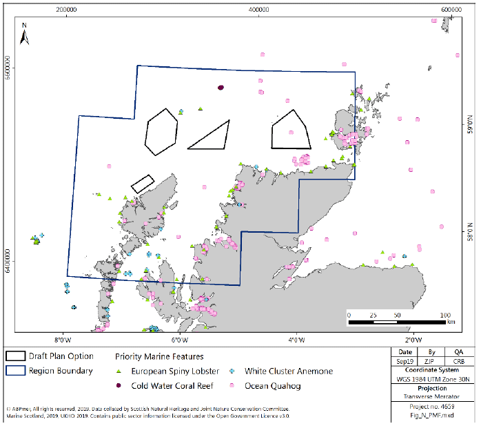
4.4.12 The majority of benthic biodiversity within the North region is concentrated around the Hebrides and Orkney Islands and the Sea of Hebrides. Around the small areas of rocky habitat in N3 there are records of benthic PMFs, including cold-water coral (identified within the area of Plan Option N3[237]), white cluster anemone (Parazoanthus anguicomus) and European spiny lobster (Palinurus elephas). There are also records of ocean quahog (Arctica islandica) within N1[238] (Figure 135).
4.4.13 In addition to the PMFs present within the Plan Options there are a range of PMF supported by benthic habitats landward of the Plan Options, including on subtidal rock habitats, inshore and shelf subtidal sediments, intertidal sediments and intertidal rocky shores.
Fish
4.4.14 The fish community in the North has high species diversity. A number of species are commercially-important and are discussed above in Section 4.3.
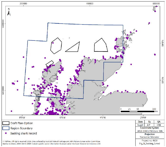
4.4.15 The region is known to be used by a number of PMFs, particularly sharks. Basking shark sightings are common in the areas around the Hebridean Islands (Figure 136), and they are known to use the seas throughout the North region. There are particular areas of high density of spiny dogfish (Squalus acanthias) on the north coast of the Scottish mainland, with the highest densities in the region west of the Orkney Islands.
4.4.16 There are a number of likely migration routes for adult returning salmon through the North region (Figure 45 in Section 2.3 shows the approximate routes, although should not be used to infer “safe” zones). These migration routes have the potential to intersect the Plan Options.
4.4.17 The North region also has important spawning grounds for sandeel, herring, cod and whiting. There is likely to be spawning ground for herring, mackerel and sandeel; low or high-intensity nursery grounds for ling, sandeel, hake, herring, whiting, mackerel, cod, tope, common skate, thornback ray, spotted ray and high-intensity nursery grounds for blue whiting, anglerfish and spurdogs.
Marine Mammals
4.4.18 Marine Mammals occur widely within the North region, including harbour seals, grey seals, harbour porpoise, Risso’s dolphin, short beaked common dolphin, Atlantic white-sided dolphin, bottlenose dolphin and minke whale.
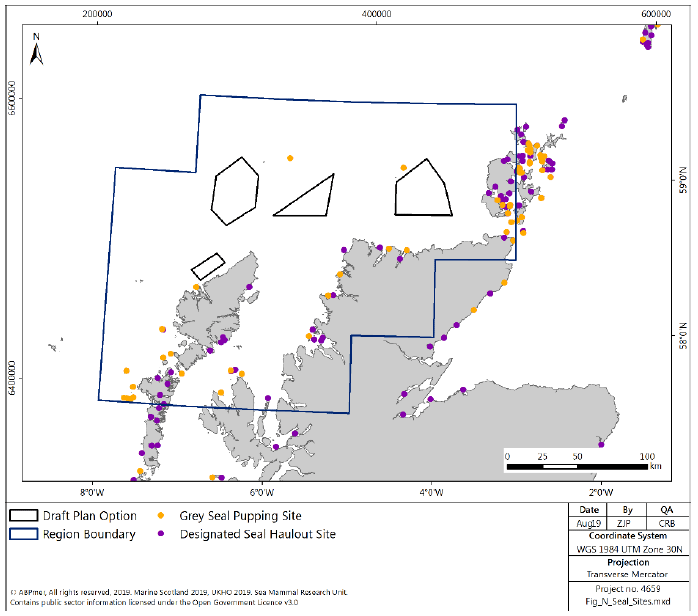
4.4.19 Both of the two species of seal found in Scottish seas have significant populations in the North region. Concentrations of seal populations are highest around the Hebrides (including a significant colony in the Monach Isles) and Orkney Islands. Grey seal breeding sites, shown on Figure 137, occur both on the outer Hebridean islands and Orkney Islands, with pup production in the Outer Hebrides and Orkney of approximately 14,000 and 24,000 respectively in 2014, contributing approximately 75 % of total Scottish grey seal production. There is no overlap with the Plan Options, however, there is one grey seal pupping site that boarders the north-west of N1 (Figure 137).
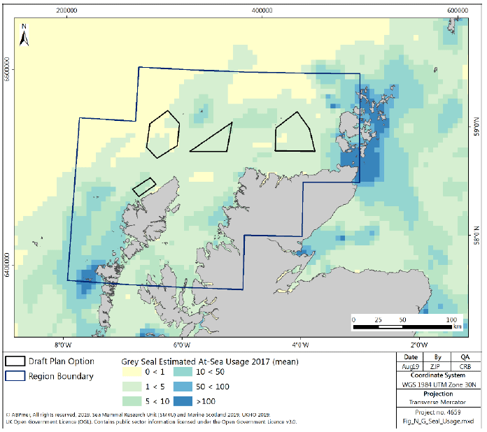
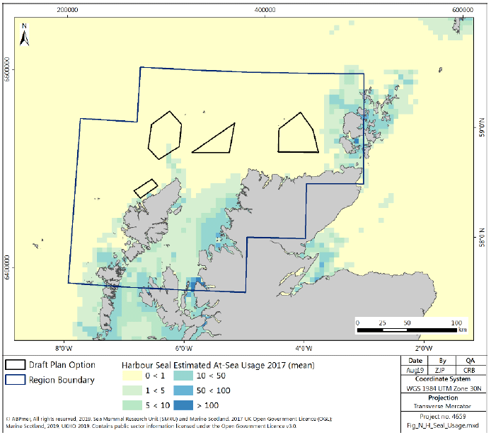
4.4.20 Grey seal at-sea usage is generally low within the Plan Options, except from part of N4 and a small proportion of N1, where there are medium levels of at-sea usage (Figure 138). Similarly harbour seal at-sea usage is low, except from a small swathe within N3 (Figure 139).
4.4.21 Population dynamics within Harbour seal populations are considerably different between the Orkney Islands, where populations have reduced considerably (reduction of 85 % between 1997- 2016) and West coast where populations are estimated to have increased by approximately 50% 2007 to 2016[239]. Harbour seal distribution is shown in Figure 139.
4.4.22 Given that most seal foraging occurs within approximately 40 to 50km of their haul out sites[240], it could be inferred that seals are likely to be using the Plan Options as foraging grounds, however the majority of seal foraging also tends to be in water depths less than 50 m[241], shallower than the majority of water depths within the Plan Options.
4.4.23 A wide variety of cetaceans are known to frequent the seas within the North region, particularly around the Hebrides, and areas to the north of the Sea of Hebrides. The Inner Hebrides and the Minches SAC is designated for Harbour porpoise, whilst the Sea of Hebrides proposed MPA is proposed for designation based partly on the population of minke whale known to frequent the area. In addition, the proposed North East Lewis MPA is proposed for designation, including for Risso’s dolphin, known to be found in high concentrations off the west and north coast of Scotland. Cetacean species densities in the North region, including harbour porpoise, bottlenose dolphin, white beaked dolphin, minke whale, short beaked common dolphin, Atlantic white-sided dolphin, Risso’s dolphin, and killer whale, when reviewed against the Plan Options, show areas of high density overlap, particularly within Plan Options N2 and N3 and N4.
4.4.24 The western isles and sea lochs on the north-west mainland and surrounding seas are known to be used extensively by otter. The majority of the usage of the seas within the North region by otter will be in coastal regions, with foraging of otters generally considered to be limited to 10 m water depths, shallower than those within the Plan Options. However, due to the inshore nature of N4, there is some potential for interaction between otters and the Plan Option.
Birds
4.4.25 The importance of the North region to birds is demonstrated in the designation of 19 SPAs and a further 5 proposed SPAs with marine elements, and additional terrestrial sites, as discussed above (Figure 131).
4.4.26 There are both breeding and non-breeding populations of a wide variety of seabirds in the North region. A number of significant seabird colonies are found either in close proximity to or directly landwards of the Plan Options. The colony at Sula Sgeir, slightly north of the area between Plan Options N2 and N3 is a particularly large breeding colony with greater than 20,000 birds including Fulmar, Gannet, Great Black-backed Gull, Guillemot, Kittiwake, Leach’s Petrel, Puffin, Razorbill and Storm Petrel. The assemblage in the North Rona and Sula Sgeir SPA, encompassing the Sula Sgeir colony, is assessed as being in Favourable Maintained condition, however the condition of the majority of the protected species within the SPA are assessed as unfavourable and declining at the last assessment in 2012 (more recent than the last assessment of the overall assemblage in 1999).
4.4.27 Sule Skerry and Sule Stack SPA is located very close to the boundary of N1. The site is designated for gannet, guillemots, Leach's petrel, puffin, shag and storm petrel[242]. The overall condition of seabird assemblages at the site is favourable.
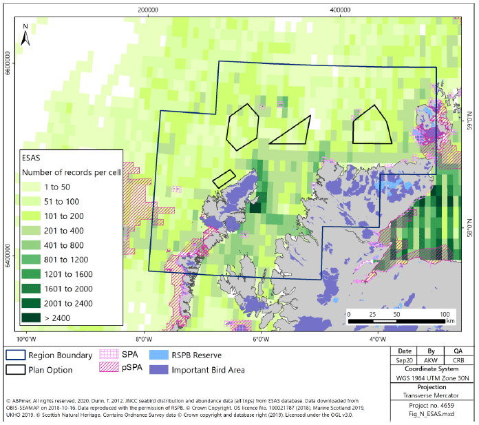
4.4.28 The condition of the species at the majority of major colonies in the North region are reviewed as part of the SPA management process. The overall condition of the seabird assemblages at the majority of locations, with notable exceptions of Handa and Shiant Isles, is favourable. However, at an individual species level a number of species are identified as being in unfavourable condition, and therefore management measures are in place to reduce pressure on these species. Species of particular importance on the west and north coast’s include black guillemots, Manx shearwater, storm petrel, red throated diver, kittiwakes, razorbill, murre and eider. Wakefield et al[243] identify that the North region, in particular the area of sea inshore of the Isle of Lewis, across the North coast and to the west of the Orkney Islands are utilised by considerable numbers of seabirds, with the multi-species analysis within the study corresponding with the areas of high recording shown in Figure 140.
4.4.29 Figure 140 maps the total records of birds recorded in the marine environment in the North region. Whilst the data mapped has not been corrected for survey effort, it highlights areas of high importance, particularly in inshore waters in close proximity to SPAs. The areas of highest concentration in the North Region are to the east and north-east of the Isle of Lewis, although recordings are high in coastal areas across the North region. There are hotspots associated with the North Rona and Sula Sgeir SPA and the IBA on the Isle of Lewis. All of the Plan Options can be characterised as having generally medium levels of abundance interspersed with areas of higher abundance. There are also a number of coastal areas identified as either IBA or RSPB reserves in the North region, covering large areas of the Outer Hebrides, the Orkney Islands and the north coast of mainland Scotland (Figure 140).In addition to seabird activity within the North region, some terrestrial bird species e.g. corncrake, whooper swan or waterfowl species may transit the area as migratory species, both during day and night time, with important summer populations on the western isles.
Cultural Heritage
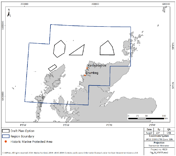
4.4.30 There are two Historic MPAs, shown on Figure 141, designated in the North region, both on the western coast of mainland Scotland, both associated with historic shipwrecks.
4.4.31 In addition to the Historic MPAs, there are a number of scheduled monuments (included protected wrecks) within the North region. Those in the marine environment are concentrated around the coast and include a wide range of historically significant buildings, shipwrecks and structures. There are seven shipwrecks designated for the protection of military remains, four near the Orkney Islands, one near the north mainland coastline near Thurso and two just North of the north-west corner of mainland Scotland. There is no overlap between protected sites and the Plan Options. There are numerous other shipwrecks distributed throughout the North region, both within and outwith the Plan Options.
4.4.32 Like the West region, within the North region there are few examples of marine palaeolandscapes (landscapes which have become submerged following occupation by hominids). This is due to the steeply sloping coastlines and deep water depths. There is therefore limited opportunity for submerged archaeological remains, and all potential sites are located within inshore coastal waters. No further detail is available on potential submerged settlements within the North region, and therefore any potential impacts on the palaeolandscapes by cable landfalls would be considered on a project by project basis.
4.4.33 Work undertaken by Project Samphire from 2013 to 2015 has recorded sites of cultural importance in the marine environment off the west coast of Scotland, principally in inshore waters and for the most part associated with vessels or aircraft[244].
Landscape / Seascape
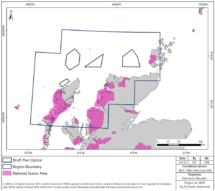
4.4.34 No specific assessment of landscape or seascape character has been undertaken on the mainland or island coastline in the North region. There are several National Scenic Areas in the North region, shown in Figure 142. The closest NSA considering open seascapes as a feature are South Lewis, Harris and North Uist.
4.4.35 Highland Council identifies SLAs within the North Region. These include areas of coastline on the north coast, including the north coast approximately 20km south of the Plan Option N1.
4.4.36 The low population density on the west and north coasts of Scotland means that the majority of the coastline in the North region can be considered to be isolated, and Scott et al.[245] identifies that there is a varied coastline in the area, with intricacies that would potentially be affected if development were to occur. All coastlines facing towards the Plan Options are assessed by Scott et al. to be of mostly medium to high or high sensitivity[246]. The exceptions to this are the north-west coast of the Hebrides and the eastern half of the north mainland coastline which are of medium sensitivity.
4.5 Planning Issues
4.5.1 There are three local authorities with coastal interests within the North region:
- Highland,
- Orkney Islands, and
- Eileen Siar.
4.5.2 Eileen Siar Council has produced a local development plan (LDP)[247], which incorporates the development of onshore manufacturing bases to support future offshore wind development, with focus on the expansion and development of currently developed land. There are no specific plans included in the LDP regarding the siting of offshore wind in proximity to the islands, although a spatial strategy for wind farms has been developed which identifies likely limitations or constraints around the islands[248].
4.5.3 Orkney Islands Council has developed a sustainable energy strategy[249] and LDP[250] for the islands, both of which consider the potential for renewable energy generation. This includes the development of supply chains to support industry, particularly considering wave and tidal stream energy projects and onshore wind, although it notes that onshore infrastructure required for offshore marine renewable energy developments will be supported where it is demonstrated will not result in significant adverse effects. There is no stated position on the potential for offshore wind development around the islands, with current focus on onshore wind.
4.5.4 The Highland Council has considered the potential for offshore wind within its area, identifying moderate potential for offshore wind within the West region in their region of responsibility around Skye.