Sectoral marine plan: regional locational guidance
Sets out regional spatial baseline data for the sectoral marine plan for offshore wind energy and describes the information used in the planning and assessment process.
2 Scottish Marine Area- National Overview of Key Issues
2.1 Physical Considerations
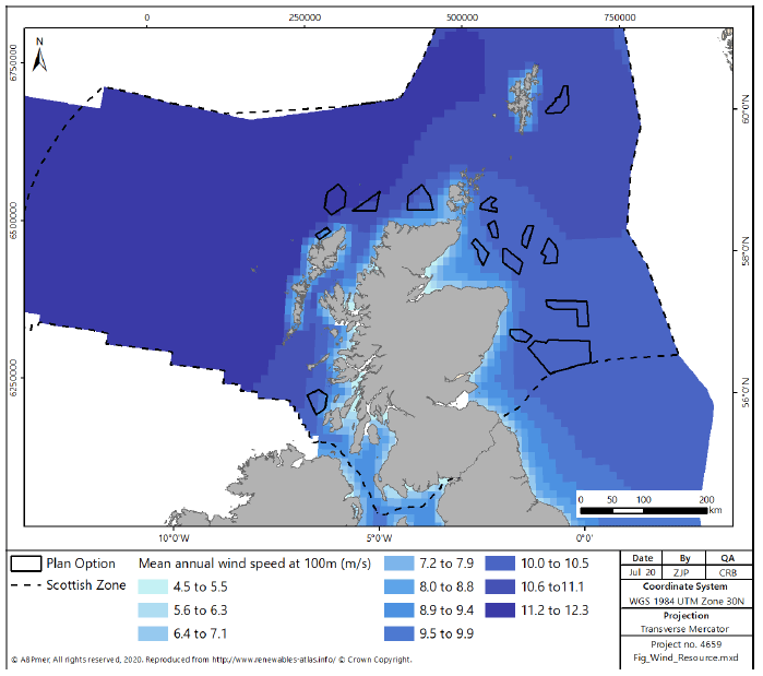
Offshore Wind Resource
2.1.1 The wind conditions across Scottish seas are generally favourable for commercial exploitation. Available data indicate that offshore areas to the west and north of Scotland provide the greatest resource. However, exploitable wind resource exists nearly everywhere in the offshore environment. The limitations on harvesting the wind resources are therefore principally due to technical limitations, including water depth, ground conditions and distance to electricity grid connections, although over time the grid can adapt to serve new locations for electricity generation.
2.1.2 Available wind resource data (Atlas of UK Marine Renewable Energy Resources[17]) show that sea areas west and north-east of Scotland provide the strongest resource. While areas to the east show relatively less wind resource, they are still sufficient to consider its exploitation, as indicated by the distribution of offshore wind farm developments currently within the consenting process.
2.1.3 Out to the 200 nm limit, as shown in Figure 5, the mean annual maximum power density (i.e. the amount of energy available at a site that can be converted to power by wind turbines) can reach a mean annual output of 1.8kWm-2. Mean wind speeds within Scottish waters reach a maximum of 11.8ms‑1 to the West of the Hebrides[18].
2.1.4 The mean values used to express this resource do not illustrate seasonal differences in the power density, or the extreme wind conditions that can occur. For example, at the 200 nm limit the mean summer power density of 0.86kWm-2 is dwarfed by the mean winter figure of 2.8kWm-2. Energy is available but the high temporal and spatial variability of this resource will influence development, this is discussed further when considering the wind resource available within the Plan Options in Sections 3 to 6.
Grid Connection
2.1.5 With current technology, there is a requirement for all offshore wind developments to be physically connected into the UK electrical grid in order to supply generated electricity for use.
2.1.6 Depending on the distance of a proposed development from pre-existing infrastructure, there is both a financial and environmental cost associated with developing the connection into the grid, including establishment of subsea cables, integration into pre-existing networks or substations and the associated maintenance requirements.
2.1.7 While the Scottish transmission grid is fixed in the short term, development of new connections and increased capacity will occur over the medium to long term to connect new sources of electricity generation, for example the East Coast onshore 275 kV upgrade (ECU2) which is progressing with an earliest in-service date of 2023. The required reinforcements of the transmission grid are identified by National Grid against the four Future Energy Scenarios[19] and are assessed for priority in the Network Options Assessment[20].
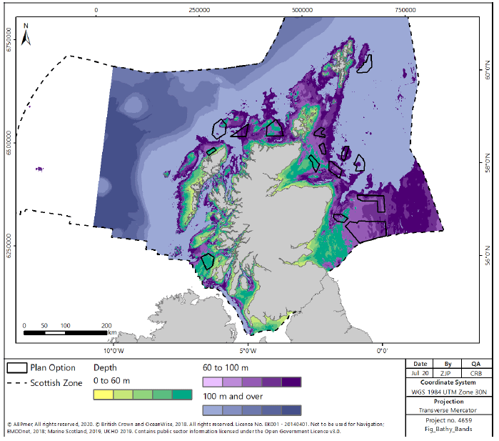
Bathymetry and Seabed
2.1.8 The water depth and bathymetry of the Plan Options will influence the feasibility of development, in both a technical and a financial sense. As described in Section 1, conventional fixed bottom substructure technologies are currently limited to depths of around 60m with floating technology more suited to deeper water. The distribution of water depths in Scottish waters is shown in Figure 6, with contours to highlight 60m and 100m limits.
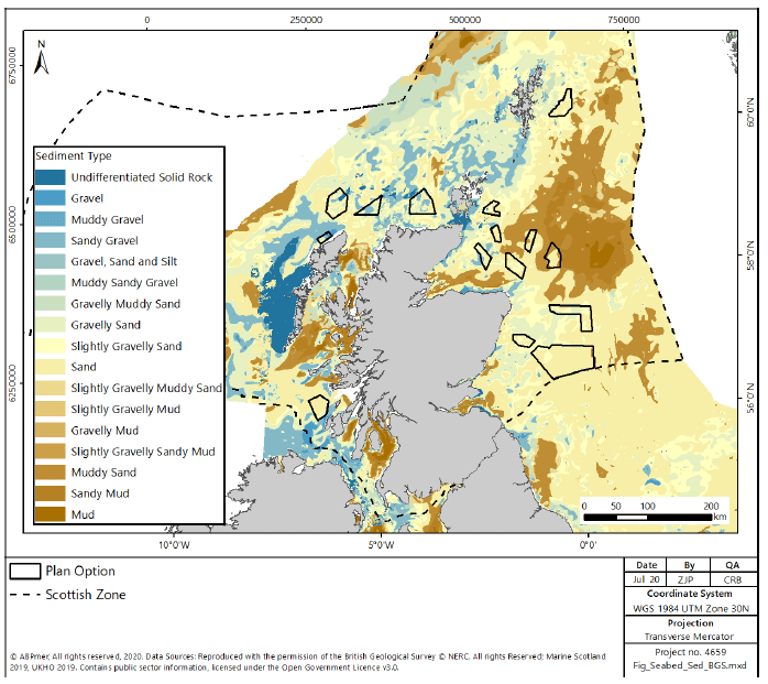
2.1.9 The seabed in Scottish waters is highly varied, with areas of hard, rocky substrate, sand, gravel and mud (Figure 7). Muddy sediments tend to be confined to the Firths and offshore on the east coast, inshore of the Outer Hebrides or further offshore on the west coast. Hard substrates are found primarily on the west coast, with further areas to the north, and around the Orkney Islands. Sand and gravel sediments are prevalent throughout Scottish waters.
2.2 Socio Economics
Supply Chain
2.2.1 The supply chain for offshore wind energy covers all the jobs associated with manufacturing, transporting and installing renewable devices, as well as related tasks such as maintenance, surveying, and operations.
2.2.2 The socio-economic impact of offshore wind in Scotland is integrally linked to the development of the supply chain within Scotland[21]. Currently, a large proportion of the materials and components for offshore windfarms are outsourced from China and mainland Europe and thus associated employment is focused outside the UK[22]. However, there is significant potential to develop local supply chains, both to support manufacturing; and operation and maintenance activities with particular opportunities identified around blade manufacture and substation construction[23]. The offshore wind supply chain is still in the early stages of development but there is existing capacity in the Scottish supply chain to support offshore wind development. Strengths of the supply chain established within Scotland include:
- Offshore engineering with expertise in construction, operations and maintenance;
- Project management and training (due to the offshore oil and gas sector);
- Design and development services including consultancy, engineering and project development services;
- Expertise in the construction of wind turbine towers, jackets and foundations;
- Research and development expertise in the private sector, academia and the public sector funded programmes;
- Existing port facilities with North Sea access and surrounding offshore service networks; and
- Fabrication and manufacturing of components.
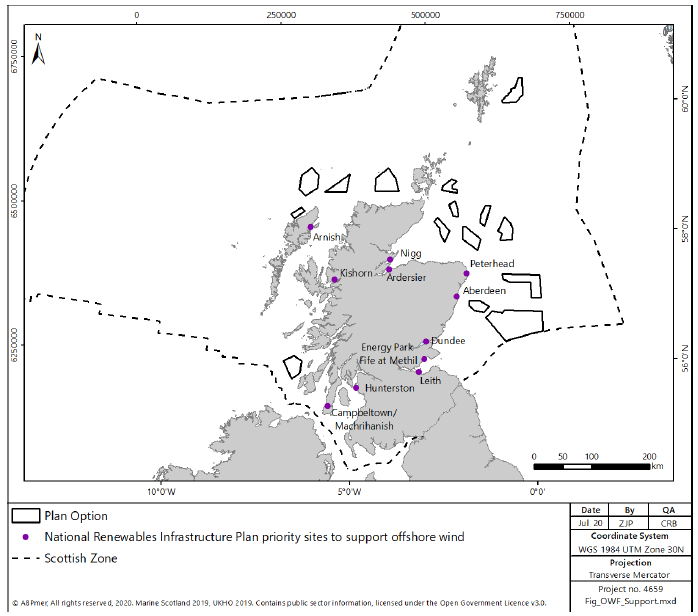
2.2.3 The National Renewables Infrastructure Plan (NRIP) identified a list of priority sites which could be developed to further support offshore wind, throughout Scotland, shown in Figure 8. These include:
- Leith- integrated manufacturing;
- Dundee- distributed manufacturing and operation/maintenance;
- Nigg- integrated manufacturing;
- Energy Park Fife at Methil- further manufacturing;
- Aberdeen- distributed manufacturing and operations and maintenance;
- Hunterston- integrated manufacturing;
- Arnish- distributed manufacturing;
- Campbeltown/Machrihanish- further maintenance and operation/ maintenance;
- Ardersier- integrated manufacturing;
- Peterhead- distributed manufacturing and operation/maintenance; and
- Kishorn- distributed manufacturing.
Energy Generation
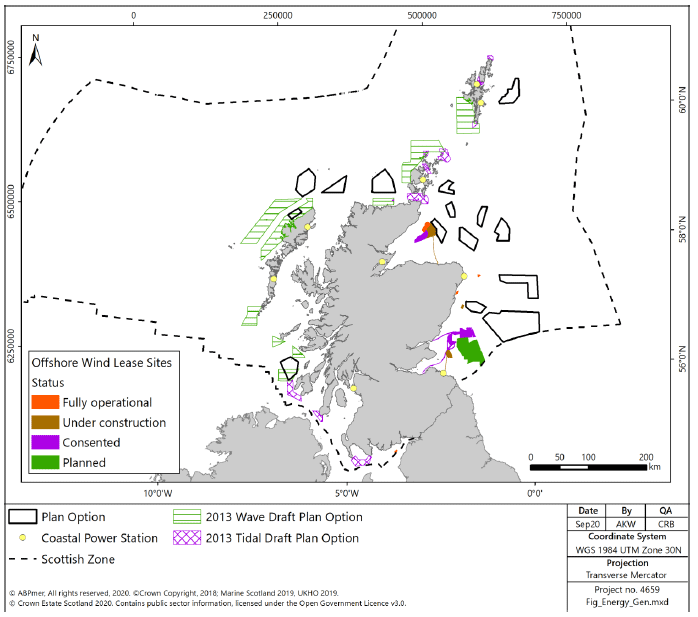
2.2.4 Scottish energy generation in the marine environment is related to the generation of energy through wave, tidal and wind devices and the transmission of this power through submarine export cables to land. Figure 9 identifies the location of existing and planned wind, wave and tidal energy development, and possible future wave and tidal plan areas.
2.2.5 All wave and tidal Plan Options and planned tidal developments in Scotland are located off the west coast of Scotland, the far north east coast of mainland Scotland, Orkney and the Shetland Islands (Figure 9). A dedicated renewable device test area (European Marine Energy Centre (EMEC)) has been in operation in Orkney since 2003 allowing developers to install single or multiple machines in a variety of site conditions.
2.2.6 At present there are no commercial wave arrays in Scotland. Wave Energy Scotland (WES) was created in 2014 (at the request of the Scottish Government), to facilitate the commercialisation of the wave energy sector through supporting projects focused on Wave Energy Converter technology, with the aim of producing reliable technology which will result in cost effective wave energy generation[24].
2.2.7 There are two operational commercial tidal-stream projects in Scotland, MeyGen in the Pentland Firth, and Bluemull Sound in Shetland, shown in Figure 9. MeyGen entered its operational phase in April 2018 following the completion of the installation of 6MW (four 1.5MW turbines) capacity in 2017, making it the world’s largest tidal stream array[25]. Forty three percent of the project expenditure was in Scotland. The MeyGen project has a further potential 392MW capacity to be installed over three further phases. The tidal array at Bluemull Sound currently operates three 100kW turbines, utilising eighty percent Scottish supply chain content, with a further three 100kW turbines planned under the EnFAIT project[26].
2.2.8 As of March 2019, offshore wind projects in waters around Scotland comprised 752MW of installed capacity[27], including Robin Rigg (Solway Firth), the European Offshore Wind Development Centre (EOWDC) (Aberdeen), Beatrice (Moray Firth), and Hywind Scotland (Moray Firth), a further 53MW in construction and 3,256MW consented and awaiting construction[28]. Further areas licenced for potential future development are shown in Figure 9.
2.2.9 In addition to the ongoing development of renewable energy in Scottish waters, there are a number of coastal power stations, including nuclear (Hunterston B and Torness), gas (Peterhead) and diesel (generally located on the Hebrides, Orkneys or Shetland) generators (Figure 9).
Power Interconnectors
2.2.10 There are approximately 650km of submarine power interconnector cables in Scottish waters[29], predominately created to connect island communities to the mainland national grid infrastructure[30] (Figure 10). The length of operational cable has now increased due to the commissioning of the Western Link High Voltage Direct Current (HVDC), with about 100km of it in Scottish waters. The new link has a capacity of 2.2 Gigawatts (GW) which will support the export of renewable energy from Scotland to England and Wales.
2.2.11 Furthermore, the Caithness-Moray HVDC transmission link has recently been constructed. It is 113km long and provides an additional 1,200MW of transmission capacity in the north of Scotland[31].
2.2.12 The power cable industry is experiencing significant growth, with several new projects currently in the installation and planning phases. Investment in these activities may be affected by economic factors in the short term. Long-term drivers for competitive electricity markets and international energy cooperation are likely to maintain the push towards increasing the level of interconnector capacity[32].To support the future growth of renewable generation, large-scale investment in Scotland’s transmission system is being delivered by a series of network development and reinforcement projects (Figure 10).
2.2.13 Scottish and Southern Electricity Networks (SSEN) plan to connect Shetland to the National Electricity Transmission System for the first time by 2021. The proposal includes a sub-sea, 260-km long, 600MW cable with on-island backup generation to replace Lerwick power station. It is currently in the early stages of development.
2.2.14 In August 2018, SSEN submitted a final needs case to Ofgem to obtain permission for a 600MW subsea cable transmission link between the Western Isles and the Scottish mainland. The company referenced the UK Government’s decision to allow remote island onshore wind to be included in future Contracts for Difference (CfD) auctions. The existing Western Isles network is close to full capacity and it is unlikely that further generation could connect without significant reinforcement[33].
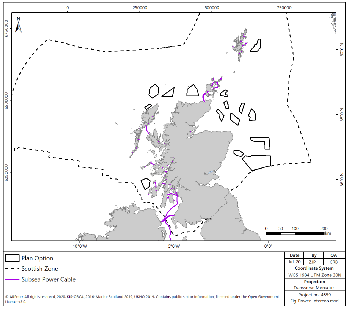
2.2.15 There is a North Connect project proposing to develop a 665km, 1400MW HVDC interconnector between Peterhead in Scotland and Simadalen in Norway. It will provide an electricity transmission link between the two nations to exchange power and increase the use of renewable energy. The intention is for the HVDC interconnector to be operational by 2023[35].
2.2.16 In addition, the Maali interconnector is proposed to link Shetland to Norway[36], in order to provide for the transfer of energy from proposed wind farms on the islands to Norway in periods of high production, and from Norway in periods of low wind.
Telecom Cables
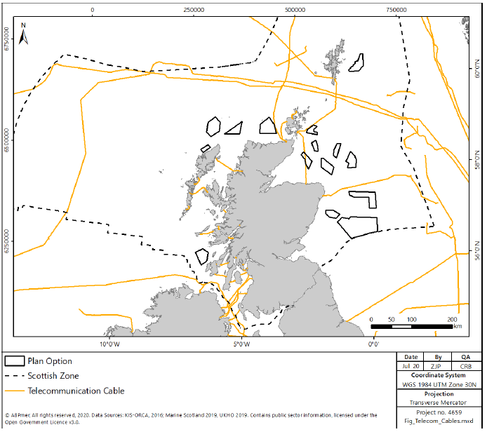
2.2.17 Telecommunication cables carry telephone calls, internet connections and data. Within the Scottish Continental shelf there are fibre optic international cable links and domestic inter-island cables which are mainly made from copper wire. There are 88 active cables in Scottish waters, spanning approximately 3,500km of international cables and 1,100km of inshore cables (Figure 11). An international network passes North and South of Shetland connecting Europe to North America, Faroe Islands, Iceland and Greenland, while networks connecting Scotland and Northern Ireland occur in waters off the west and south west of Scotland. Cables also connect the Scottish mainland and island communities. Cables tend to be laid on or under the seabed with shallow gradient and soft sediment and finding the most suitable route around obstructions.
2.2.18 The overall UK telecoms and communications sector has recently been estimated to contribute approximately £63 billion to the economy[37] and employs approximately 270,000 people across 8,000 companies[38].
2.2.19 A further preliminary estimate of the economic value of the UK telecommunications subsea cables industry to the digital economy values it at £62.8 billion per annum[39]. The only known estimate that has been published estimates that about 26,750 jobs in the UK telecommunications sector are marine-related[40]. Through an analysis of cable ownership data, a crude estimate could be made of the average investment in telecommunication cables by the UK at £134m per year[41].
2.2.20 Increasing use of the internet and e-commerce has led both to an increasing demand for communication cables and for faster services which has meant that the capacity of cables has also grown[42].
2.2.21 According to the European Subsea Cables Association (ESCA) around 97% of international trans-ocean traffic is carried by cable, hence, submarine cables will be vital for the foreseeable future. However, there is little information available on the extent to which new cables will be laid in Scottish waters[43].
Carbon Capture and Storage
2.2.22 Carbon capture and storage (CCS) is a technology that will enable fossil fuels to be used with substantially reduced CO2 emissions. CCS combines three distinct processes:
- Capturing the CO2 from power stations and other industrial sources;
- Transporting it (usually via pipelines) to storage points; and
- Injection of the CO2 into deep geological formations (e.g. deep saline formations or depleted Oil and Gas fields) for long term storage.
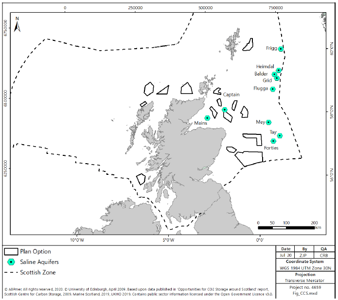
2.2.23 There are currently no full-scale demonstration or commercial projects in operation within the UK. However, Drax, power station (Selby) has started a pilot project to capture CO2 from its wood combustion and other projects are anticipated to begin by the 2020s[44]. Previously, Scotland has been identified as having a large CO2 storage resource[45], with 29 hydrocarbon fields and 10 saline aquifers identified as having the apparent potential to store CO2, all of which are in offshore waters within the Central and Northern North Sea. Figure 12 identifies the centre point of the most significant saline aquifers within Scottish waters, recognising that these will underlie much of the seabed in the surrounding areas. Of the identified aquifers, the Captain aquifer may have the highest likelihood of being developed, having been identified by the ACT Acorn project as its principal site for development in the early 2020s utilising pre-existing oil and gas pipelines to transport the CO2, thus reducing project costs[46].
2.2.24 As an emerging sector there remains uncertainty regarding the likely future development of CCS in Scotland. A number of CCS programmes initiated within Scottish waters have been unsuccessful, following changes in UK Government policy and lack of funding[47]. The UK government[48] has committed to funding development and innovation in Carbon Capture Usage and Storage technology. The Committee on Climate Change (CCC) continues to highlight CCS as an important sector for the UK as a whole[49] and Scotland[50] to meet CO2 emissions targets. The CCC has recommended that the Carbon Capture Usage and Storage Council publishes a CCS deployment pathway, and reviews delivery and investment models[51], consistent with achieving the goal of having the first CCS cluster operational by 2026.
2.2.25 There is currently no information available on the economic value or employment associated with CCS, however the Scottish Government and Scottish Enterprise stated that emerging CCS-based industry in Scotland could support up to an estimated 10,000 jobs by 2025[52]. This figure was estimated prior to the loss of funding for a number of CCS projects in Scotland, therefore whilst the CCS sector still has the potential for considerable job creation, this is likely to be delayed beyond the 2025 date identified above. Further reviews have identified that, in order for the European Union to achieve ‘Net Zero’ by 2050 CCS is likely to be important. There is therefore an opportunity for the industry in Scotland to support significant sequestration from European sources. Should the potential of the industry be maximised, this has the potential to support 22,000-105,000 jobs by 2050[53].
Oil and Gas
2.2.26 This sector relates to the extraction of oil and gas from offshore reserves. Oil reserves include both oil and the liquids and the liquefied products obtained from gas fields, gas-condensate fields and from the associated gas in oil fields. Gas reserves are the quantity of gas expected to be available for sale from dry gas fields, gas-condensate fields and oil fields with associated gas.
2.2.27 The offshore extraction of oil and gas makes a significant contribution to the UK economy. In 2017 the UK accounted for 1.1% of the total production of oil and gas. The industry generated £13.4bn in 2016 and supports more than 36,000 jobs[54].
2.2.28 The oil and gas industry is the principal source of fuel and power for Scotland, meeting approximately 90% of the primary energy need in Scotland in 2015[55]. The total revenue from oil, Natural Gas Liquids (NGL) and gas progressively decreased between 2014 (20,326 million tonnes) and 2016 (15,293 million tonnes) before increasing in 2017 (18,824 million tonnes). It was estimated that the oil and gas industry was worth £9.2 billion to the Scottish economy in 2016[56] and in 2017-18 the sector accounted for 96% of the UK’s crude oil and NGL production[57]. However, the Scottish oil and gas sector has experienced a significant decline in production revenue compared to previous years as a result of depletion of reserves and low oil and gas prices.
2.2.29 The oil and gas sector provides an important source of income and employment and in 2017 employed approximately 114,000 people across Scotland[58]. The sector currently supports over 280,000 jobs across the UK, including 36,800 directly employed by oil and gas companies and major contractors. Around 127,000 people are employed in the wider supply chain and 119,700 people are in jobs induced by the economic activities of employees.
2.2.30 About 39% of the jobs supported by the sector are in Scotland, not only in major cities such as Aberdeen but across the whole of Scotland including more remote areas of the country.
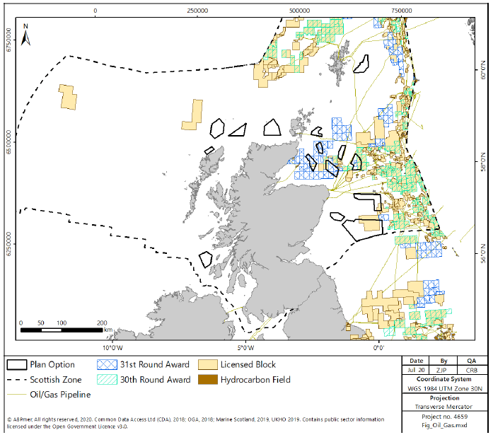
2.2.31 There is extensive infrastructure associated with oil and gas development in Scottish waters, including seabed and platform mounted production facilities and networks of pipelines bringing oil and gas ashore for processing[59], as shown in Figure 13. It is estimated that there is approximately 12,800km of oil and gas pipeline in Scottish waters with most pipelines outside the 12 nm limit. Virtually all hydrocarbon fields, platforms, pipelines and infrastructure occur within the central and northern North Sea and to the west of Shetland.
2.2.32 The North Sea fields are generally mature, but there is the potential for significant new development to occur west of Shetland. This includes the gas discovery announced in September 2018 of a significant gas reservoir at Glendronach to the west of Shetland[60]. The discovery has the potential to be developed quickly, due to the proximity of current infrastructure to the site.
2.2.33 Oil and gas production is projected to gradually decrease in the period to 2035. Oil and Gas UK forecasts that 66% of the UK’s energy mix will still come from oil and gas by 2035 (Ibid). National Grid predicts that by 2050, green gas will make up 39% of the UK’s gas demand[61] and the CCC considers that low carbon energy generation could contribute to 75% of the UK’s energy by 2030[62].
2.2.34 It is likely that oil and gas exploration will continue to decline in light of commitments to achieve net zero by 2050.
Aviation
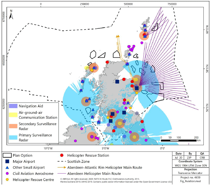
2.2.35 Aviation forms a critical component of Scotland’s economy by providing both direct access to markets and lifeline services to otherwise inaccessible settlements throughout the mountainous and island terrain. Helicopter routes are also important in servicing offshore oil and gas installations (Figure 14).
2.2.36 Scotland’s five major airports are in the west (Glasgow and Glasgow Prestwick), north east (Inverness and Aberdeen) and east (Edinburgh). Smaller airports are located on the mainland in the east (Dundee), north east (Wick) and west (Campbeltown) and on the islands in the north (Scrabster, Lerwick and Sumburgh in the Shetlands; Kirkwall in the Orkneys), north west (Stornoway, Benbecula and Barra in the Outer Hebrides) and west (Coll, Colonsay, Tiree and Islay). All Scottish airports are shown on Figure 14.
2.2.37 Primary and secondary surveillance radars are used by air traffic control at airports. Large portions of the Scottish coast are within radar surveillance areas (Figure 14). The areas with greatest coverage are around Tiree, Aberdeen and Peterhead. There are also secondary surveillance radars around Tiree, Aberdeen, Peterhead, Glasgow, Sumburgh and Stornoway.
2.2.38 Edinburgh is the busiest airport in Scotland and in 2016 contributed almost £1 billion into the Scottish economy and employed approximately 23,000 people[64].
2.2.39 Major or important airports in Scotland are safeguarded aerodromes, protecting the aerodrome operations from interference, such as from developments, wildlife strike, inappropriate lighting and radar interference. In the context of wind turbines, the Airport Operators Association recommends that any proposed wind developments within 30km of a safeguarded airport should be assessed by the aerodrome for potential physical impacts[65]. Further, all proposed wind developments should undertake consultation with the aerodrome and NATS regarding impacts on radar services.
Defence
2.2.40 Scottish Waters (including territorial waters and the Exclusive Economic Zone) are extensively used in direct support of UK defence. MOD strategic interests relevant to the Scottish zone are to:
- Retain the capability to store, maintain and deploy the deterrent;
- Free navigation for surface and subsurface naval vessels for national defence;
- Safeguarding of navigational routes and nationally critical infrastructure;
- Safeguard the usage of designated Danger Areas and Exercise Areas for military training and defence test & evaluation purposes; and
- Retain strategic maritime infrastructure, installations and coastal MOD facilities.
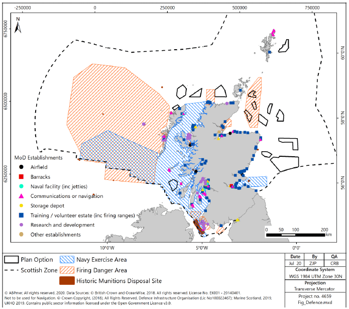
2.2.41 Military activities occur in both inshore and offshore waters around Scotland. Principal marine-related defence activities include sea transport by naval vessels and sea training. Activities relating to maritime transport are mainly associated with naval bases and the only naval base in Scotland is Her Majesty’s Naval Base (HMNB) Clyde at Faslane in the West Region. Sea training is carried out within defined military practice and exercise (PEXA) training areas. The Navy’s Scottish Exercise Areas (SXAs) occur around the coast of Scotland, although these are predominantly located off the west coast, while firing danger areas and ‘other’ exercise areas occur in all offshore energy regions (Figure 15). Although the PEXA cover large areas of sea, military exercises cover only a proportion of these areas at any one time and are restricted temporally to a few weeks per year. The major training exercise each year is the Joint Maritime Course in which Navy, Army and RAF exercises are conducted off the Scottish North West coast and which lasts for two weeks[66].
2.2.42 There are two low flying Tactical Training Areas in Scotland, however the majority of training is overland as the sea does not provide a challenging enough environment for training purposes[67]. Additionally, there are a number of safeguarded coastal MOD Aerodromes and MOD Technical sites which require consideration.
2.2.43 In addition to military establishments in the public domain (Figure 15), it is recognised that further military assets may be present in the region. Any concerns regarding assets of this type will be identified in consultation with the MOD at a project level.
2.2.44 Historically, areas of sea around Scotland have been used to dispose of munitions, both conventional (explosives) and chemical. Methods of disposal varied, but included disposal of munitions individually, particularly focussed on the area around Beaufort’s Dyke[68]. In addition, a number of ships were loaded with a variety of munitions, prior to being scuttled in the seas around Scotland. The records of the vessel locations and cargoes are generally poorly kept; however, the majority of wrecks lie in water depths greater than 200 m[69] and current records do not indicate overlap between the Areas of Search and potential munitions disposal sites (Figure 15).
2.2.45 The MOD employs people throughout the UK in support of its operations in the marine environment, including HM naval bases, MOD ranges and coastal estates.
Fishing
2.2.46 Fishing is an important economic activity in Scottish waters and has strong socio-cultural elements in maintaining the vigour and coherence of coastal communities, particularly in rural and island locations.
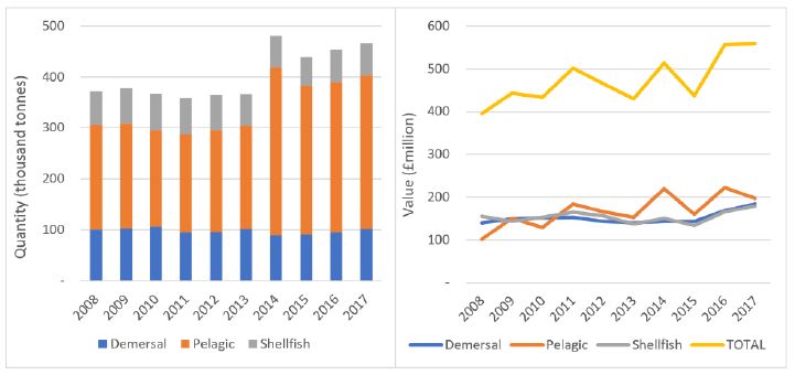
2.2.47 Scotland is one of the largest sea fishing nations in Europe and in 2017 Scottish-based vessels landed 466,000 tonnes of fish and shellfish into the UK and abroad, with a value of £560 million[70]. Compared to 2016, this represents a 1% decrease in value in real terms and a 3% increase in the quantity landed. These landings constituted 64 % of the quantity, and 57 % of the value, of all landings by UK vessels into the UK and abroad[71]. The overall trend over the last ten years has been of increasing value of landings, with a significant increase in volume of landings in 2014 from the pelagic sector (Figure 16).
2.2.48 The pelagic species mackerel and herring are of particular importance to the Scottish fleet and in 2017, these species (together with blue whiting and horse mackerel) made up 65% by volume and 35% (£197 million) of the total value of landings made by Scottish vessels. Demersal species (including haddock, monkfish and cod) made up 22% by volume and 33% by value of landings by Scottish vessels, with a total value of £184 million. Shellfish landings (including Nephrops, scallops and crabs) made up 13% by volume and 32% by value of all landings by Scottish vessels with a total value of £180 million[72].
2.2.49 Mackerel is the single most valuable species to the Scottish fishing industry at £162 million (29% of the total value of Scottish landings in 2017) followed by Nephrops at £75 million (13% of the total value of Scottish landings in 2017). Haddock (£42 million), scallops (£40 million) and monkfish (£36 million) were the next most valuable species landed by Scottish vessels in 2017[73].
2.2.50 Shellfish is particularly important (from a value perspective), particularly for inshore areas of all regions and also for the offshore areas of the North East and East regions. Demersal fishing is most valuable for the offshore areas of the North, North East and Shetland regions, whilst pelagic fishing is important for the offshore areas of the North and North East regions.
2.2.51 The location of fishing activities is dependent on the species being targeted. Mackerel is fished in the North Sea from September to December and off the west coast from January to March. Herring is caught in the North Sea, around Fair Isle, and Cape Wrath in the summer months. Nephrops fishing is very tightly linked with the areas of muddy seabed favoured by this species. The most actively-fished grounds are in the Fladens, Moray Firth, Firth of Forth and the Long Forties in the east. On the west coast, this fishery is active from the North Minch down to the Clyde[74].
2.2.52 A variety of sizes of vessel participate in the Scottish fishing industry, from the 70 metre pelagic trawlers to the under-10 metre inshore creelers. There were 2,065 active Scottish-based vessels in 2017, made up of 1,503 vessels of fleet ten metres and under in length (73%) and 562 vessels over ten metres in length[75]. Vessels larger than 12 m in length are obliged to carry a Vessel Monitoring System (VMS) that allows fishery compliance offices to monitor their activity. VMS has been a requirement for vessels over 12 m length since 2012, however full implementation across the fleet was delayed and so for some of the time-series of data reported, VMS data were not available for all years for vessels 12-15m length. In this report, activity of non-VMS vessels has been represented using other methods, including ScotMap (from participatory mapping by under-15m vessel operators) and landings at the scale of International Council for the Exploration of the Sea (ICES) statistical rectangles. The value of landings by larger vessels is approximately ten times that of the smaller inshore vessels. However, monetary value and the cultural significance of fishing are not necessarily synonymous.
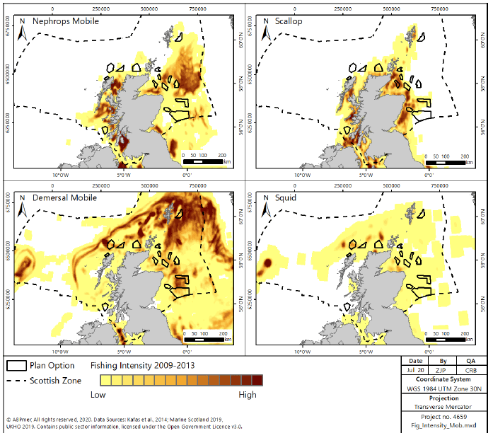
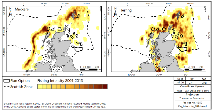
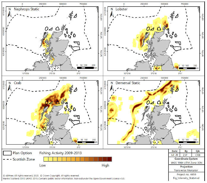
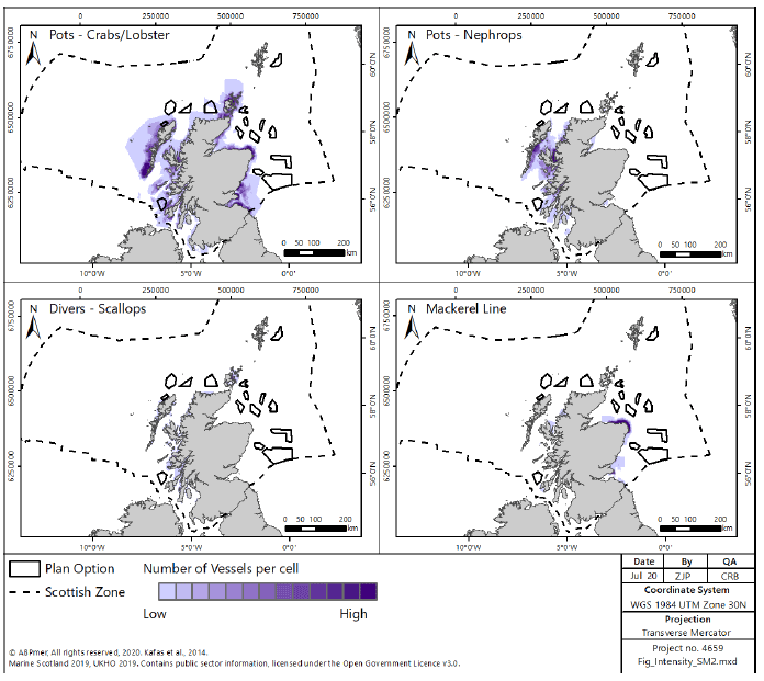
2.2.53 Fishing by over-15m vessels takes place throughout Scottish waters on the continental shelf. Mobile demersal gears (Figure 17) operate in inshore areas around the Scottish coast, targeting Nephrops and scallops, as well as further offshore on the Fladen Grounds in the North Sea for Nephrops. Gears targeting demersal fish (e.g. cod, haddock) operate off the west coast along the shelf edge, around Shetland and in the North Sea. The squid fishery has developed substantially in recent years (post 2013) in the North Sea area, and particularly along the Moray/Buchan coast. Over-15m vessels targeting pelagic species (Figure 18) operate offshore west of Scotland and around Shetland for mackerel, and north of Scotland and in the North Sea for herring. Over-15m vessels using static gears (Figure 19) operate mostly north and west of Scotland – inshore in North Minch and the Clyde with Nephrops creels, west of the Outer Hebrides and around Orkney targeting lobster, off the north and west coasts targeting crab, and along the shelf edge targeting demersal fish. Note that these figures show the distribution of effort from 2009-2013, prior to the construction of the current round of windfarms, and therefore may not be an accurate reflection of the current distribution of effort.
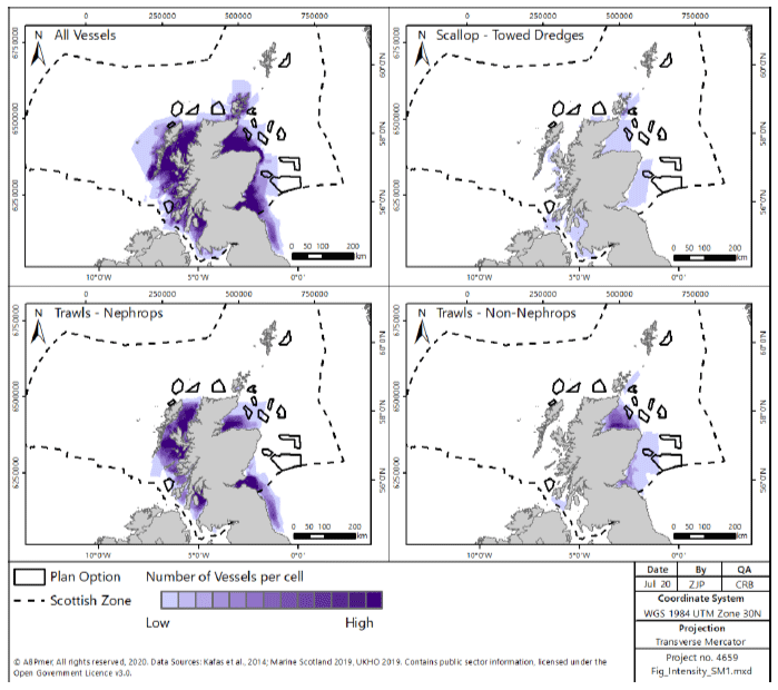
2.2.54 Under-15m vessels operate mostly in inshore areas, having a more limited operating range (Figure 20). Nephrops trawls are active on the west coast, from North Minch to the Clyde, and in the Moray Firth and Firth of Forth. Other (non-Nephrops) trawls operate on the Moray, Banff and Buchan coasts. Creels or pots for crab, lobster and Nephrops (Figure 21) are used throughout the west coast, around Orkney and in the Firth of Forth.
2.2.55 The data in Figure 20 and Figure 21 do not cover the Shetland area (as the Scotmap exercise did not cover Shetland), where 39,000 tonnes of fish and shellfish, worth £50 million were landed by Shetland boats from Shetland waters in 2016[76]. Whitefish made up 53% of the value, pelagics 39% and shellfish 8%.
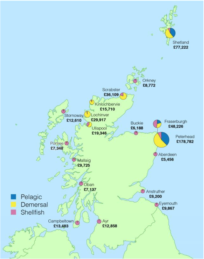
2.2.56 In 2017, 341,000 tonnes of fish and shellfish were landed into Scotland with a value of £505 million. This represents a 2% decrease in both tonnage and in real value since 2016[77]. Landings into ports on the south-west coast and south-east coast were dominated by shellfish, while landings into north-west ports were mostly demersal and into the north-east were mostly pelagic. The three largest districts in Scotland in terms of total tonnage landed were Peterhead (east coast), Shetland (north) and Fraserburgh (east coast) (Figure 22).
2.2.57 In 2017, 4,799 fishers were working on Scottish-based vessels, representing 0.2% of the total Scottish labour force[78], and 6% of the marine economy employment[79]. Fraserburgh is the district with the largest number of fishers (753), accounting for 16% of the total in 2017. However, employment in fishing accounts for a higher percentage of overall employment in island communities (Shetland, Orkney and Na h-Eileanan Siar local authorities) and in Argyll and Bute, where it exceeded 2% and 1%, respectively[80]. This highlights the importance of fishing to these communities.
2.2.58 In 2016, fishing generated £296 million GVA, accounting for 0.2% of the overall Scottish economy, and 8% of the marine economy. From 2015 to 2016 the GVA from fishing (adjusted to 2016 prices) increased by 34%, while the longer term trend from 2008 to 2016 showed that fishing GVA increased by 63%.[81] The highest GVA by district was generated in Aberdeenshire (£131 million), the Shetland Islands (£72 million), Highland (£30 million) and Argyll and Bute (£14 million).[82]
2.2.59 There were 152 fish processing sites in Scotland in 2016 (for the processing of saltwater (sea fish) and salmon & freshwater fish)[83]. The majority of these (39%) were in the Grampian region, with 23% in Highlands and Islands, and the remainder in ‘Other Scotland’. This provided 8,380 full-time equivalent (FTE) jobs in Scotland, a decline of 12% since 2008. GVA of the sector was £341 million in 2014.
Aquaculture
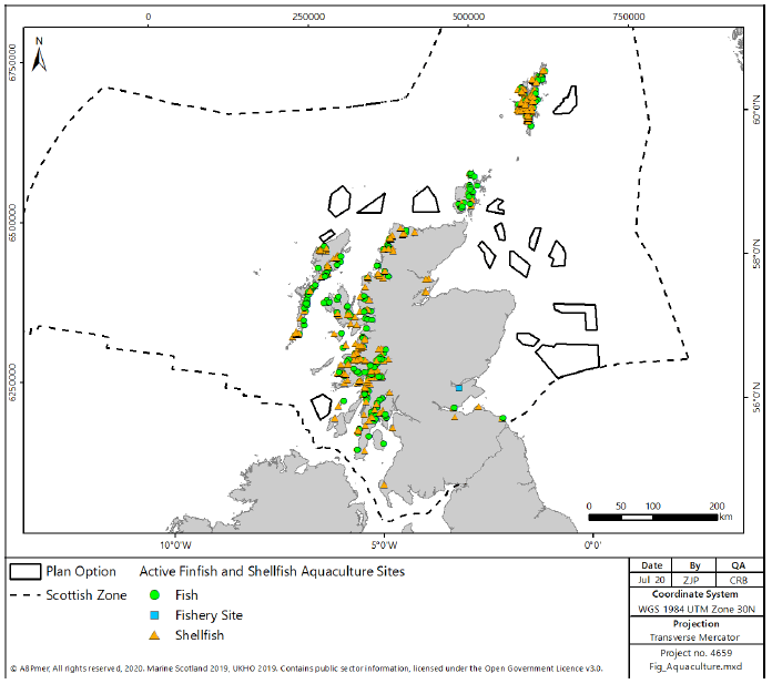
2.2.60 Marine aquaculture is an increasingly important industry for Scotland and helps to sustain economic growth in rural and coastal communities. It involves the farming or culturing of fish, molluscs, crustaceans or algae and produces Scotland’s most valuable food exports. Aquaculture sites in Scotland are currently situated in coastal areas within a few miles of the shore with no sites found further offshore. Most sites are located in the sheltered lochs, bays and sounds of the West coast including the Hebrides and around Shetland with far fewer sites located on the East coast (Figure 23). The Scottish Government[85] aims to double the economic contribution of the sector from £1.8 billion in 2016, to £3.6 billion by 2030.
2.2.61 Finfish aquaculture is important to the Scottish economy. Scotland is the largest producer of farmed Atlantic salmon in the EU[86] and the third largest worldwide[87]. Finfish aquaculture in Scotland is dominated by the farming of Atlantic salmon, although the production of rainbow trout significantly contributes to the industry. Other species farmed in 2016 included brown/sea trout, halibut, lumpsucker and several species of wrasse (the latter two species produced for use as cleaner fish for the biological control of parasites in the Atlantic salmon production industry).
2.2.62 In 2016, there were 253 active sites farming salmon, producing a total of 162,817 tonnes of Atlantic salmon, virtually all of which was produced in sea cages (only 21 tonnes of salmon were produced in seawater tanks on land). In the same year, there were 44 active sites farming rainbow trout (although only 7 sites which were sea-based), producing a total of 8,096 tonnes, of which 3,759 tonnes (46%) were produced from sea cages[88].
2.2.63 The number of staff employed in the production of Atlantic salmon was 1,486 (1,379 full time and 107 part-time)[89]. In the same year, 121 staff were employed in the production of rainbow trout (100 full-time and 21 part-time), whilst 53 staff were employed in the production of other fish species (43 full-time and 20 part-time)[90].
2.2.64 In 2017, there were 132 authorised shellfish aquaculture businesses in Scotland, operating 332 active sites, of which 53% were producing shellfish for the market (i.e. for consumption)[91].
2.2.65 Shellfish production was dominated by mussels and Pacific oyster, although small quantities of scallop, queen scallop and native oyster were also produced. Additional species farmed in small quantities in 2017 were shrimp and periwinkle.
2.2.66 In 2017, shellfish aquaculture in Scotland produced 8,232 tonnes of mussel and 403 tonnes of Pacific oysters for consumption. The vast majority of the mussel production in Scotland is located in Shetland, which accounted for 6,647 tonnes (81%) of the total mussel production in Scotland in 2017[92]. The production of Pacific oysters was mostly limited to the Strathclyde and Highland regions.
2.2.67 In 2017 the total value of shellfish aquaculture in Scotland was estimated at £12.4 million. Mussel cultivation contributed the most to the value of the sector during 2017; valued at £10 million, while Pacific oysters amounted to £2 million; native oysters £0.12 million; scallops £0.09 million and Queen scallops £0.003 million[93].
2.2.68 The Scottish shellfish cultivation industry employed a total of 146 full-time and 182 part-time and casual workers during 2017. The highest number of full-time staff were employed in Shetland (61), followed by Strathclyde (41), although Strathclyde had the highest number of staff in total (105 full-time and part-time/casual, compared to 100 in Shetland)[94].
2.2.69 Although there is interest and research into the viability of cultivating seaweed (e.g. for bioenergy production and speciality food ingredients) in Scotland, at present, there is no commercial scale cultivation of seaweed and this sector is limited to research/trial sites. As such, seaweed is not considered further within the RLG, as the location and scale of seaweed aquaculture is very uncertain.
2.2.70 The Scottish finfish aquaculture industry has ambition to grow aquaculture production to 350,000 tonnes for marine finfish (approximately double the average harvest for 2014/2015) by 2030[95] [96]. The shellfish aquaculture industry has ambition to grow production to 21,000 tonnes for mussels by 2030[97]. How expansion of the industry is achieved (e.g. via expansion of on-shore, near-shore and/or offshore aquaculture) and to what extent these ambitions are realised will depend on several factors including the level of social acceptance of aquaculture, markets and economics, availability of marine space at sites with suitable environmental conditions and technological developments. Future potential scenarios for aquaculture in Scotland have been explored in several studies[98,99,100]. There is likely to be continued growth in the aquaculture sector in the future, however, the location, timing and intensity of such development remain uncertain. It is likely that there will be some development further offshore.
Ports and Harbours
2.2.71 Within Scottish waters, the ports and harbours sector supports the largest fishing industry in the UK and provides facilities for a significant offshore oil and gas industry, as well as maintaining ferry links to island communities and providing the recreational sector with support services.
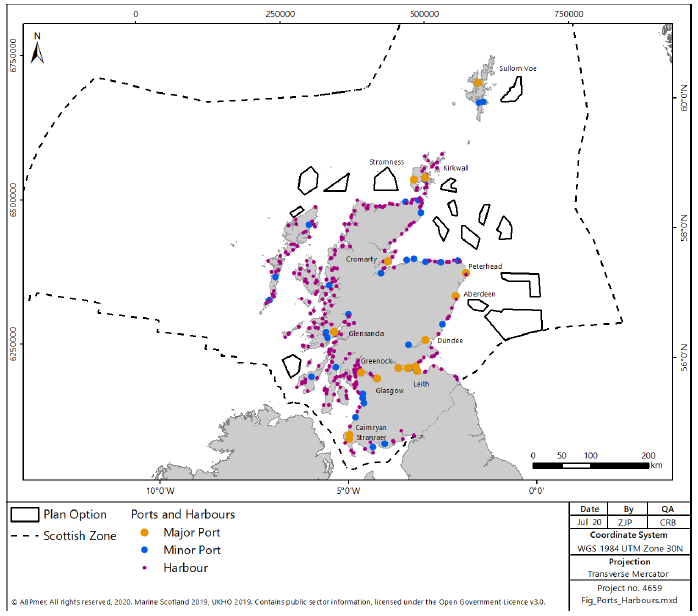
2.2.72 There are 11 Scottish ports classified under the EC Maritime Statistics Directive as a major port handling at least 1 million tonnes of cargo per year; an additional 5 major Scottish ports are also reported by the Scottish Government. Overall, there are around 270 ports and harbours in Scottish waters, ranging from very small piers and landing stages, to those with major facilities. Figure 24 shows their distribution. They include:
- Large Oil and Gas terminals, e.g. Hound Point (Firth of Forth), Sullom Voe (Shetland), Flotta (Scapa Flow, Orkney);
- A large quarry product port, e.g. Glensanda;
- Large fishing ports, e.g. Peterhead, Fraserburgh;
- Smaller fishing ports, e.g. Buckie, Mallaig;
- Oil supply ports, e.g. Aberdeen, Cromarty Firth;
- Multi-purpose ports, e.g. Leith, Clyde;
- Large container ports, e.g. Grangemouth; and
- Major ferry ports serving Ireland and Europe, e.g. Cairnryan, Stranraer and Rosyth.
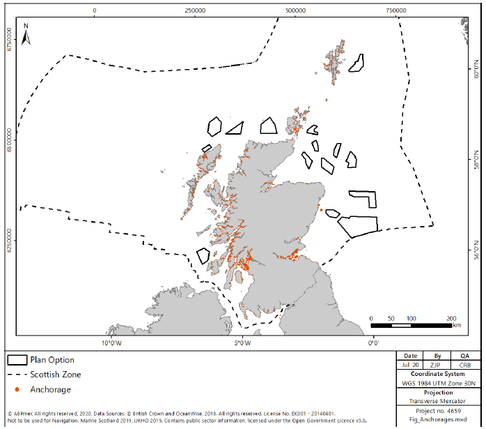
2.2.73 Anchorages are located all around the Scottish coastline in inshore waters, but areas of highest densities are along the west coast, Orkney, the Moray Firth and the Firth of Forth, as shown in Figure 25.
2.2.74 Cargo and passenger figures are published each year in the Scottish Transport Statistics and the Department for Transport Maritime Statistics[101,102]. In 2016, Scottish ports handled 66.7 million tonnes of cargo and 10.1 million passengers were carried by ferries, with 33,000 vessels arriving at Scottish ports from Europe during the same period. In 2015, a total of 44.5 million tonnes of freight was recorded as being lifted by water transport in Scotland: 14.2 million tonnes of coastwise traffic to other ports in the UK (including Scotland), and 2.2 million tonnes of one port traffic to offshore installations.
2.2.75 Smaller scale local ferry services, mainly between the Scottish mainland and outlying islands provide an important lifeline for residents and local industry. This service also opens a gateway for tourists to visit areas that might otherwise be inaccessible by car or train. Examples of this type of link include services provided by CalMac, Orkney Ferries, Northlink Ferries and Shetland Islands Council. For example, the total number of passengers carried on routes within Scotland was 8.3 million in 2016. This provides considerable economic and social benefit to both the port and harbour operators and dependent communities, allowing for the movement of commercial traffic, local passenger traffic and growing numbers of tourists and visitors[103].
2.2.76 Within Scotland’s National Marine Plan[104] five objectives for “Shipping, Ports, Harbours and Ferries” were set out. These seek to ensure the industry develops as a key part of Scotland’s economy. The future use, growth and development of ports are intrinsically linked to world trade patterns and the economic climate and are reactive to changing economic circumstances.
Shipping
2.2.77 Shipping is an important industry for Scotland, with shipping movements related to the movement of cargo, ferry lifeline services and oil and gas operations alongside large shipbuilding centres in the Clyde and Firth of Forth.
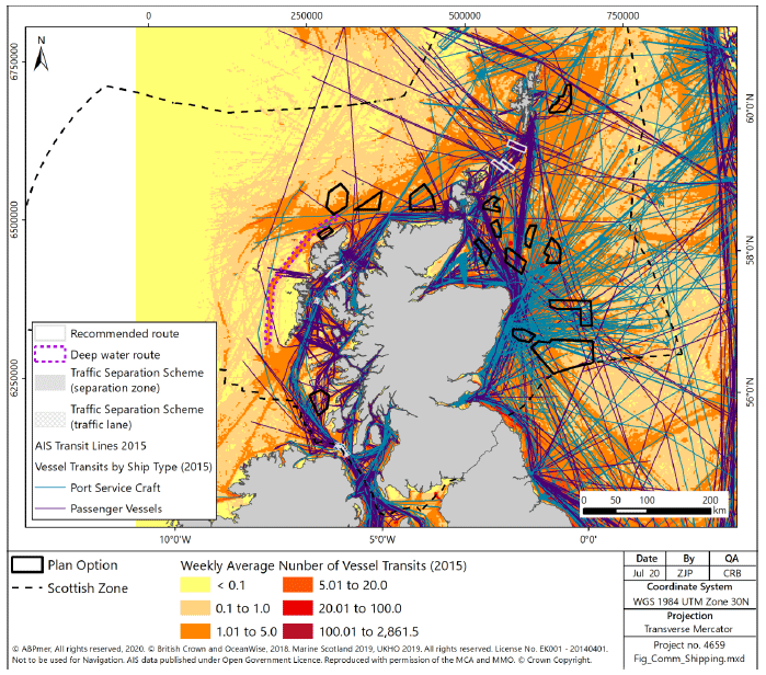
2.2.78 AIS density grid data (Figure 26) from 2015 (the major routes are unlikely to have changed) indicates key transport routes up the west coast of Scotland through the North Channel (or Straits of Moyle) and the Minches, and east–west between the northern coast of the mainland and Orkney, from where vessels access the North Sea. In addition, there are routes transiting through Scottish waters, such as to the north of Shetland connecting Denmark to the Faroe Islands and onwards to Iceland and routes crossing the Atlantic to America.
2.2.79 Some of the areas showing the highest intensity of vessel movement include ferry routes (e.g. between Northern Ireland and Loch Ryan, between the Outer Hebrides and Oban via the Sound of Mull and between the Shetland Islands, Orkney and the Scottish mainland) and within the Clyde.
2.2.80 There are two International Maritime Organisation (IMO) Traffic Separation Schemes (TSS) (Figure 26), designed to ensure safe shipping in areas of particularly high density, one in the North Channel between the Mull of Kintyre and Northern Ireland, and the other in the Minches between Skye and the Outer Hebrides. There is additionally one IMO recommended deep water route to encourage deep drafted vessels to the west of the Outer Hebrides to reduce traffic in the Minches.
2.2.81 Ferry services to the Scottish islands are considered lifeline services, in that they provide key connections between communities on the islands and mainland Scotland, allowing for transport of key commodities and people, including supporting the tourism trade. The key ferry paths, identified in Figure 26, are of high importance to the Scottish population.
2.2.82 Oil and Gas related traffic, correlated to the port services traffic identified in Figure 26, is concentrated on the east coast of Scotland, with hubs around Aberdeen, Peterhead and Fraserburgh contributing to the high density of maritime traffic in that area.
2.2.83 There are Areas To Be Avoided (ATBA) within Scottish waters (Figure 26), with large areas notified around the Shetland Islands, Fair Isle, and the Orkney Islands aimed at reducing risks associated with high traffic density around the islands.
2.2.84 Whilst the high density of traffic is an indication of importance of an area to the industry, there are areas of lower density for which navigational access is of relatively higher importance, such as related to the transit of oil and gas rigs to oil fields or returning to ports for decommissioning.
2.2.85 In 2015, shipping contributed an estimated £3,600 million GVA to Scotland (25% of the UK total) and it was estimated 39,300 of the UK nationals employed in the shipping industry (21% of the UK total) were based in Scotland[105].
2.2.86 Shipping volumes bear a direct relationship to the global economic market. As markets react to the changing financial situation, shipping lines respond with services to move goods and people. The most notable variable to affect the volume and intensity of shipping into the future will be the technology and innovations used to design future shipping. Ship design seeks for bigger, faster and more economic transhipment of goods and people[106].
Coastal and Flood Protection
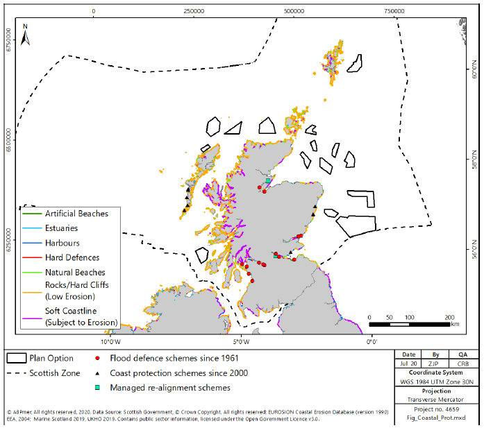
2.2.87 There is currently no nationally collated database of historic coastal and flood defence assets, although coastal flood protection schemes that had been approved since 1961 are archived by the Scottish Government in the Scottish Flood Defence Asset Database (SFDAD). Scottish Natural Heritage (SNH) estimated that 307km of shoreline on mainland Scotland’s coast comprises coastal defences[107]. The distribution of coastal protection schemes and hard and soft engineered flood prevention schemes constructed since 1961 is shown in Figure 27.
2.2.88 Future sea level rise and the potential for increasingly severe storm events due to climate change may place Scotland’s coastal infrastructure and habitats under increasing threat[108,109]. The Flood Risk Management (Scotland) Act, came into force in November 2009. This legislation implemented a framework for a co-ordinated and sustainable approach to flood risk management in Scotland. At the heart of this approach is a series of assessments and plans designed to improve the understanding of flooding and to target investment in actions where they are most needed. Scottish Environment Protection Agency (SEPA) conducted a national assessment of flood risk in 2011 and a flood risk management planning report in 2012 which described in more detail how the flood risk management planning process will work. In December 2015, following consultation, 14 local FRMS were published which set out how flood risk will be managed, coordinated, funded and delivered between 2016 and 2022. Each FRMS identified priority areas at significant flood risk and 42 suggested schemes were put forward to reduce the impact in these areas[110].
Marine and Coastal Recreation
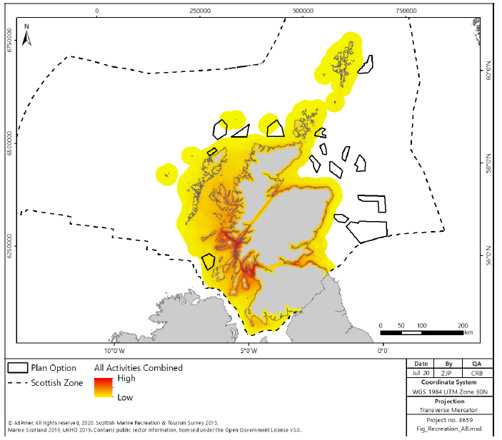
2.2.89 A wide variety of recreational activities take place in coastal and inshore areas (Figure 28). The annual expenditure on marine recreation activities in Scotland was estimated to be around £3.7 billion in 2016[111]. It is expected that levels of participation in water sports activities will increase in the long term and the key locations that water sports are currently undertaken around the Scottish coast are likely to remain the same due to access, facilities and necessary sea conditions.
Boating
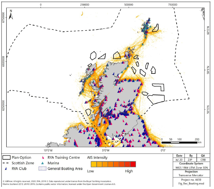
2.2.90 Recreational boating is a popular pastime in Scotland and is economically important for the country. Scotland, particularly the West coast but with destinations around the coastline, is identified as being one of the world’s best destinations for sailing, receiving visitors from elsewhere in the UK and those from Scandinavia and the rest of continental Europe. Data from the Royal Yachting Association[112] indicates that boating is concentrated in the Clyde and along the West coast, the Moray Firth, Solway Firth and the Firths of Tay and Forth which are traditional cruising grounds for recreational sailors and power boaters (evidenced by the high density of activity and RYA infrastructure in these areas in Figure 29). Recent developments along the East coast, and within the Orkney and Shetland Isles, have increased the potential for cruising between the Caledonian Canal and the Shetlands with well-placed facilities and stopping points en route.
2.2.91 In 2016 recreational boating was estimated to have contributed £67.7 million GVA and supported 2,740 jobs[113]. With respect to future trends, it is estimated that with development of the market (e.g. increased berths and facilities), the net additional increase in GVA of this sector could increase by between £9.7 to £11.9 million over the period to 2020 compared to 2016, with associated increases in employment of between 394 to 480 jobs. Scotland’s Marine Tourism Strategy ‘Awakening the Giant’ sets a target to develop and lead the growth of sailing in Scotland from £101 million visitor expenditure in 2015 to £145 million by 2020[114].
Angling
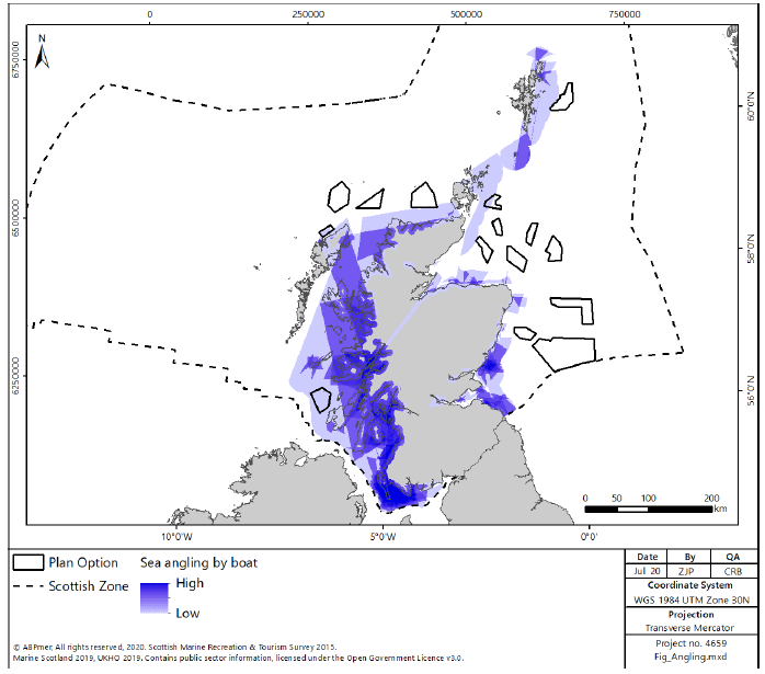
2.2.92 Recreational sea angling is carried out along most of the Scottish coastline, both from the shore and from boats (generally within 6 nm) (Figure 30). The Scottish Sea Angling Conservation Network (SSACN) confirms that the highest densities of anglers are found in the more heavily populated areas of coast around Glasgow, Clyde, Edinburgh and Fife[115]. Sea angling launch points are also concentrated along the Argyll coast and islands, Solway Firth, Firth of Clyde, Firth of Tay, North coast, and East Grampian coast[116]. Sea angling in Scotland supported 3,148 jobs in 2008, representing an income of around £70 million[117].
Scuba Diving
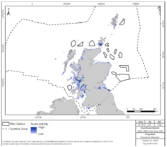
2.2.93 The most popular locations for scuba diving around Scotland are Scapa Flow, Orkney (considered to be one of the best wreck diving areas in the world) and the Marine Reserve of St Abbs and Eyemouth off the Berwickshire coastline. The islands of the Inner Hebrides, the Firth of Forth and the East coast from North of Dundee to the Dornoch Firth are also popular diving destinations (Figure 31).
Sea Kayaking and Canoeing
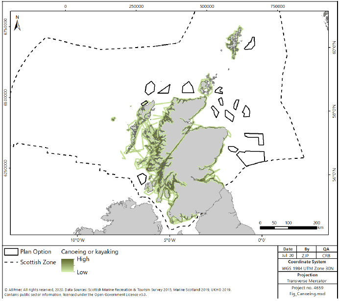
2.2.94 The Scottish coastline provides high quality opportunities for kayakers and canoers with an abundance of interesting sea caves, inlets and wildlife to explore. The majority of trips are close inshore, however, open crossings are regularly undertaken by more experienced paddlers (Figure 32). Sea kayaking and canoeing has the potential to be undertaken along most of the Scottish coast and is only constrained by the availability of suitable launching spots such as beaches or slipways.
Surfing and Windsurfing
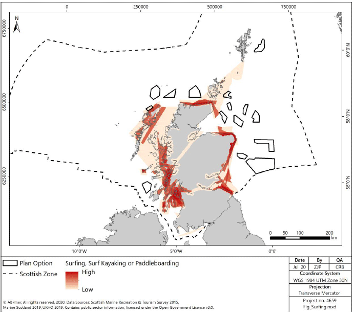
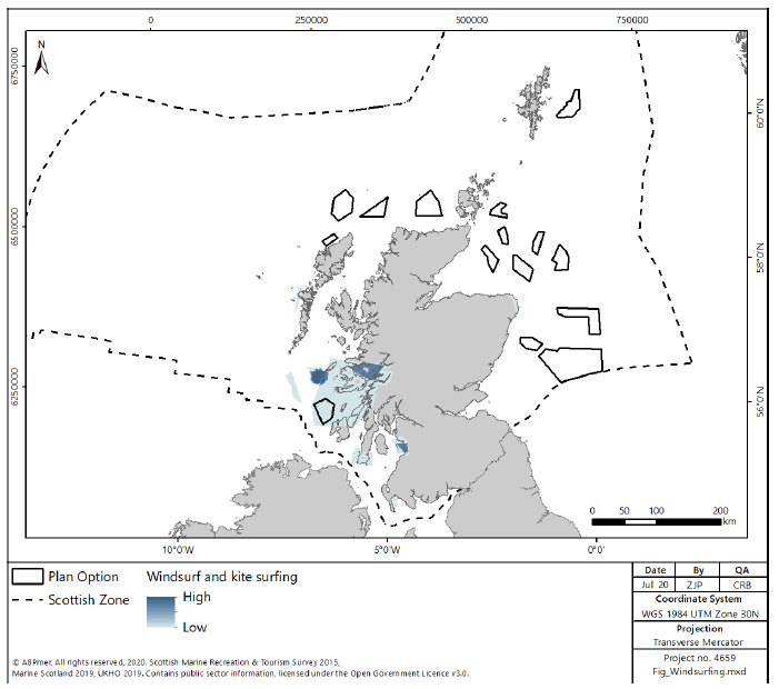
2.2.95 With its long coastlines, clear waters and surrounded by the Atlantic Ocean with swells throughout the year, Scotland is one of Europe’s top surfing destinations. Surfers are willing to travel large distances to undertake surfing at good quality spots, meaning that remote areas with good waves bring economic benefits to rural areas from the visiting surfers (Figure 33 and Figure 34). Surfing is popular along the Southeast coast. But bigger waves can often be found on the Western and Northern coasts with competitions such as the Tiree Wave Classic and events by the Professional Windsurf Association being held there.
Tourism
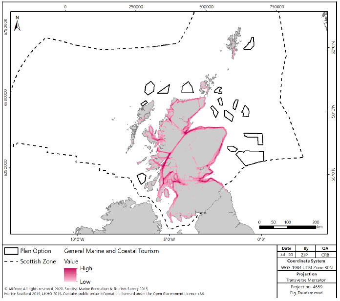
2.2.96 Tourism is essential to the Scottish economy and the marine and cultural heritage environments are key attractions for tourists.
2.2.97 Tourism has been defined by Visit Scotland as ‘a stay of one or more nights away from home for holidays, visits to friends or relatives, business/conference trips or any other purpose excluding activities such as boarding education or semi-permanent employment[118]’. For the purpose of this RLG, day trips have also been included. This can include a range of activities such as walking along the sea-front to surfing. Both non-motorised (walking/picnicking) and motorised (boat-based tourism such as wildlife viewing) activities are considered here.
2.2.98 The value of Scotland’s marine tourism sector in 2015 was estimated to be £594 million GVA[119].
2.2.99 The popularity of wildlife tourism in Scotland is likely to be influenced by the high quality marine environment and opportunities for wildlife watching. There are a number of designated Marine Protected Areas (MPAs) which cover approximately 20% of the Scottish marine environment reflecting the quality of wildlife and habitats within Scottish waters. There are 48 marine Special Areas of Conservation (SACs) in place to protect species and habitats such as coral reefs, seals and bottlenose dolphins. There are 45 Special Protection areas (SPAs) that help protect a variety of migratory birds and 61 Sites of Specific Scientific Interest (SSSI) which offer further environmental protection.
2.2.100 Use of the marine environment for Tourism related activities is reflected in distribution as shown in Figure 35. There are particularly high concentrations in the West region around the Clyde and the Inner and Outer Hebrides with other hotspots around the Firth of Forth, Firth of Tay and Moray Firth.
Social Considerations
2.2.101 Coastal communities, living within 5km of the coast, account for an estimated 41%[120] of Scotland’s total population and the regional analysis shows that the characteristics of these coastal communities varies significantly between the different regions.
2.2.102 Different parts of the Scottish coast experience different types of pressures. Some areas are sparsely populated and have fragmented communities, and others are more densely populated city regions.
2.2.103 Most parts of the coast have an ageing population, and all regions are expected to experience an increase in the average age of the population over the coming years[121].
2.2.104 The Scottish Index of Multiple Deprivation (SIMD) highlights that coastal communities have varying levels of access to employment, education and services. The views on quality of life also vary between coastal communities. Regions such as the north, north east and east show positive trends, whereas the west and north west are experiencing a decline[122].
2.2.105 The profile of key employment sectors varies between regions. There is a high dependence on the service economy, but other industries such as agriculture, forestry and fishing accounts for a greater portion of jobs in the more remote, rural regions than in communities closer to the urban and accessible parts of the coast.
2.3 Environment
Designated Sites
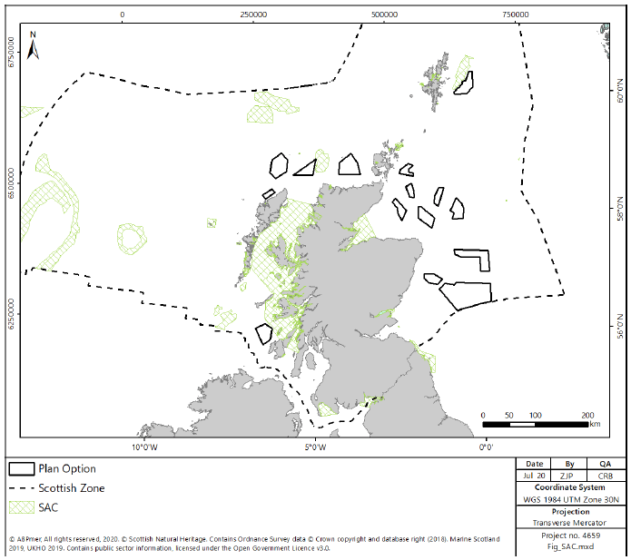
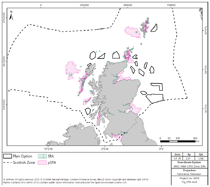
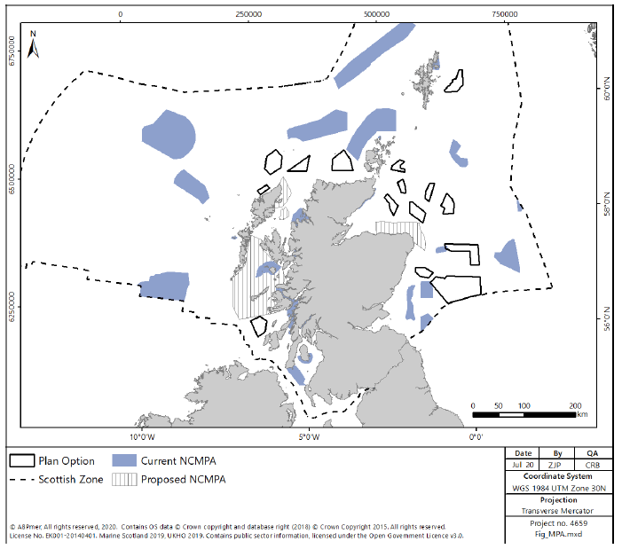
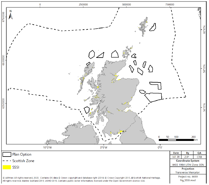
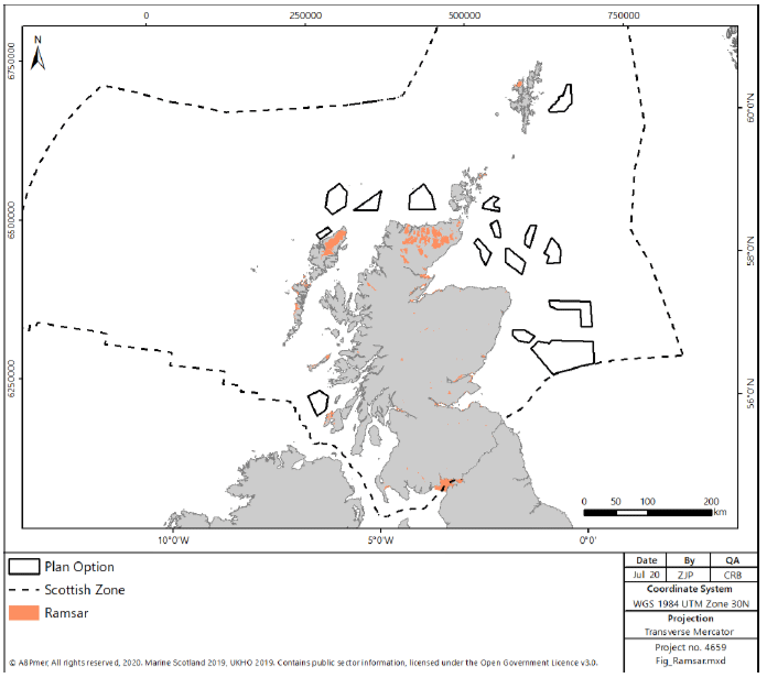
2.3.1 The importance of Scotland’s marine ecosystems is reflected in the range of designations which protect them at the international and national levels. All designations are included and incorporated into Scotland’s Marine Protected Area (MPA) Network currently covering approximately 20% of Scottish seas. The current designations, shown in Figure 36, Figure 37, Figure 38, Figure 39 and Figure 40 are:
- Special Areas of Conservation (SAC): these include both inshore and offshore SAC and cover eleven different marine habitat types which occur in Scotland (sandbanks which are slightly covered by seawater all the time; estuaries; mudflats and sandflats not covered by seawater at low tide; coastal lagoons; large shallow inlets and bays; reefs; submarine structures made by leaking gases; and submerged or partially submerged sea caves). Seven marine species that occur in Scotland are also protected (bottlenose dolphin, harbour porpoise, grey seal, harbour seal, sea lamprey, Atlantic salmon and otter). There are further SACs within riverine environments which are designated for migratory fish, whose migration routes may intersect the Plan Options;
- Special Protection Areas (SPAs): these protect and are of international importance for a number of bird species (e.g. seabirds, waders, ducks and geese). SPAs are designated in both the coastal / marine and terrestrial environments for species which have the potential to interact with regions within the Plan Options;
- Nature Conservation MPAs (NCMPA: these protect habitats and species such as maerl beds, coral gardens, and common skate; and
- Sites of Specific Scientific Interest (SSSI): these are nationally designated sites which protect species such as seabirds and seals, and habitats such as sea caves and rocky shores.
2.3.2 In addition, Ramsar sites (Figure 40) are designated for their internationally important wetlands. Each Ramsar site is also designated as either a SPA or SAC, depending on the features present.
2.3.3 Currently there are 17 NCMPAs (Figure 38) designated for nature conservation purposes under the Marine (Scotland) Act 2010 (NCMPAs) and 37 SACs designated under the EU Habitats Directive (Figure 36) located within territorial waters (i.e. within 12nm of the territorial baseline). A further 13 MPAs and 11 SACs are designated in the offshore environment (i.e. from 12 nm from the territorial baseline, or within non-territorial waters). There is one additional MPA designated for demonstration and research purposes, Fair Isle D&R MPA, designated in 2016. The Scottish Government is considering plans for the designation of four additional NCMPAs around the Scottish coast and there is potential for an additional deep sea MPA.
2.3.4 There are 58 current SPAs in Scotland (Figure 37) with marine or coastal components, 31 of which are extensions to seabird colony SPAs designated under the EU Birds Directive to protect a range of vulnerable breeding, overwintering or migratory bird species and assemblages. The Scottish Government has consulted on a further 15 proposed SPA which are identified for designation in the marine environment (consultation closed 9 November 2018). Fourteen of these sites are expected to be taken forward with SNH and JNCC recommending that the Pentland Firth SPA is withdrawn[123].
2.3.5 There are 61 SSSI (Figure 39) for the further protection of species such as seabirds and seals and habitats ranging from sea caves and rocky shores. There are also 51 Ramsar sites (Figure 40) designated as internationally important wetlands, covering a total area of about 313,000 hectares.
2.3.6 The Habitats Directive also affords protection to certain species of plants and animals (European Protected Species). In the marine environment these include cetaceans and otters.
2.3.7 In addition to the marine and coastal SAC shown in Figure 36, there are a number of riverine SAC identified for migratory fish throughout Scotland. These are shown in the figures for the regional descriptions.
Priority Marine Features
2.3.8 In July 2014, Scottish Ministers adopted a list of 81 Priority Marine Features (PMFs). PMFs are species and habitats which have been identified as being of conservation importance to Scotland. Most are a subset of species and habitats identified on national, UK or international lists. The National Marine Plan includes a policy (GEN 9 Natural Heritage) for safeguarding PMFs whereby “Development and use of the marine environment must not result in significant impact on the national status of PMFs”.
2.3.9 The list of 81 PMFs comprise 26 broad habitats (e.g. burrowed mud), seven low or limited mobility species (e.g. ocean quahog), and 48 mobile species, including fish (e.g. blue ling) and marine mammals (e.g. minke whale). There is a significant body of data regarding the abundance of PMFs within Scottish waters. However, where a lack of records is observed in an area, this may be as a result of a lack of survey effort, rather than the absence of PMFs.
Water Quality
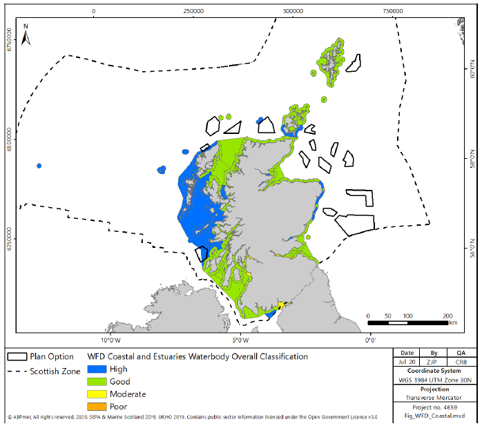
2.3.10 The Water Framework Directive (WFD) requires that Member States monitor and assess surface and ground waters and develop and implement plans for improvements in water quality where standards are not met. The majority of the 505 coastal and transitional water bodies in Scottish Waters, as represented in Figure 41, are classified as either good status (342) or high status (155), however some areas have been classified as moderate (7) or poor (1), principally due to pressures on morphology and macro-invertebrates[124].
2.3.11 There are 86 designated bathing areas in Scotland, of which 59 are assessed as excellent or good status, 16 are assessed as at target objective and 11 are assessed as poor status. There are 80 designated shellfish waters in Scotland. Twenty-nine are assessed as at target objective, with the remaining 51 assessed as not at target objective.
Benthic Habitats and Species
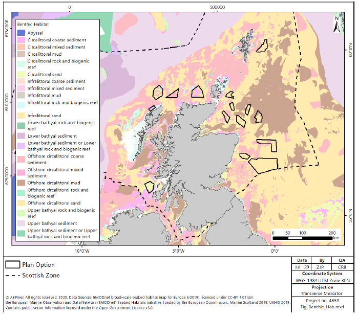
2.3.12 Benthic (seafloor) habitats and species are vital natural resources, as many marine species rely, directly or indirectly, on the seafloor to feed, hide, rest or reproduce. Generally benthic habitats are characterised by low mobility species[125]. Habitats within the Scottish marine environment can be characterised into broad groups; intertidal habitats, subtidal (inshore and shelf sea), and deep sea habitats, broken down by substrate type (Figure 42) and discussed below.
2.3.13 The Scottish Marine Atlas[126] assessed the current condition and any potential trends associated with benthic habitats at a regional level[127]. The current condition of benthic habitat within Scottish waters is varied, with certain habitats under greater pressure, generally dependent on the level of human activity undertaken. There were few or no concerns about subtidal rock. Intertidal rock and sediments show evidence of deterioration, with one concern being the introduction of non-native invasive species such as wireweed (Sargassum muticum), a brown alga. The most significant level of concern related to the condition of shallow and shelf subtidal sediments, mainly as a result of fishing practices such as demersal fishing (trawling) and scallop dredging. There were also some concerns about the effects of trawling on deep sea habitat, although such activity has now been banned under EU regulation 2016/2336[128].
Intertidal Habitats
2.3.14 The intertidal area of the Scottish coastline can be characterised based on substrate type, including rocky (48%) and sedimentary (mobile shingle and gravel, sand and mud (50%), sandflats and mudflats (2%)),[129].
2.3.15 Intertidal rocky habitat, which is usually sub-divided using wave exposure ranging from extremely exposed to extremely sheltered, supports an abundance of marine life in Scottish seas, including macroalgae and various invertebrate assemblages, some of which are nationally and internationally important populations. The upper foreshore is generally species poor, with species richness increasing with depth below mean high water springs.
2.3.16 Intertidal sediment supports communities of vascular plants (saltmarsh), biogenic reefs, mussel beds, burrowing worms, crustaceans and bivalve molluscs that are adapted to be tolerant of exposure to air, and varying temperatures and salinities. The community structure tends to be species poor, but high in productivity[130]. Priority Marine Features supported by intertidal sediments include seagrass beds, blue mussel beds and native oysters.
Subtidal (Inshore and Shelf Sea) Habitats
2.3.17 Subtidal habitats in Scottish waters in water depths less than 200 m are predominantly subtidal rock or inshore and shelf subtidal sediment.
2.3.18 Subtidal rock communities, particularly prevalent on the west coast, are typically dominated by seaweed in the photic (light) zone above approximately 20m, with animal dominated communities at greater depths. Kelp forests are prevalent, particularly on the west coast where water clarity and the proportion of subtidal rock habitat is high. Subtidal rock supports populations of several PMFs in Scottish waters as described by the Scottish Marine Atlas[131].
2.3.19 Subtidal inshore sediments are defined as extending from the lower limit of the intertidal to the point where there is no effect from waves (limit at approximately 50-70 m) with subtidal shelf sediments defined as extending from the limit of inshore sediments to the edge of the continental shelf (limit at approximately 200 m). The inshore and shelf subtidal sediments comprise an extensive area of the subtidal seabed within Scotland, with subtidal shelf sediments comprising the majority of the east coast subtidal area within the North Sea. Inshore and shelf sediments support a variety of animal assemblages including several PMFs[132].
2.3.20 In addition, subtidal inshore mud sediments support the commercially important Norwegian lobster (Nephrops norvegicus, otherwise known as langoustine), discussed in Section 2.2 above.
Deep Sea Habitats
2.3.21 Within Scottish waters, deep sea habitats are found almost exclusively to the west and north of Scotland and include cold water coral reefs, coral carbonate mounds, submarine canyons, sea mounts and deep-sea sediments. There is also some (> 200 m water depth) abyssal plain habitat within Scottish waters.
2.3.22 Benthic habitats in the deep-sea support a considerable biomass and are considered to be the largest ecosystem on earth[133]. However, ecological information is sparse for deep sea habitats for all but a few species[134].
Fish
2.3.23 Scotland’s territorial waters support approximately 250 different species of fish, with additional species occurring in deeper waters within the Scottish Marine area. Some species are commercially important to the Scottish fishing industry (discussed in Section 2.2 above). Of the 250 species identified in Scottish waters 40 are cartilaginous fish (Chondrichthyes), incorporating species of shark, rays and skates[135]. There are 31 species of fish identified as Priority Marine Features within Scottish waters[136].
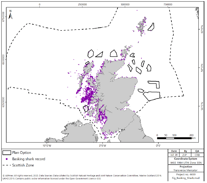
2.3.24 Basking sharks are distributed around the Scottish coastlines, shown in Figure 43, with areas of increased observations on the west coast. The aggregations on the west coast have been highlighted as potential breeding grounds[137]. Basking sharks have been identified as a key species for protection within Scottish waters and are a designated feature in the Sea of Hebrides pMPA.
2.3.25 There are several migratory diadromous fish species found within Scottish waters and which use Scottish rivers for spawning, including Atlantic salmon, sea trout, lamprey and shad, plus the European eel which spawns at sea after a prolonged period growing in fresh water. Many migratory species are protected, generally through SAC in riverine environments.
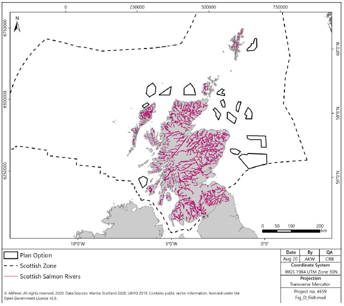
2.3.26 Scotland is a stronghold for Atlantic salmon with nearly all rivers which are accessible to upstream migrating salmon other than those with poor water quality containing salmon populations as shown in Figure 44. The largest salmon rivers with the largest populations of salmon are on the east coast. The sea feeding grounds are remote from Scottish marine waters which the outgoing smolts and returning adult fish must pass through.
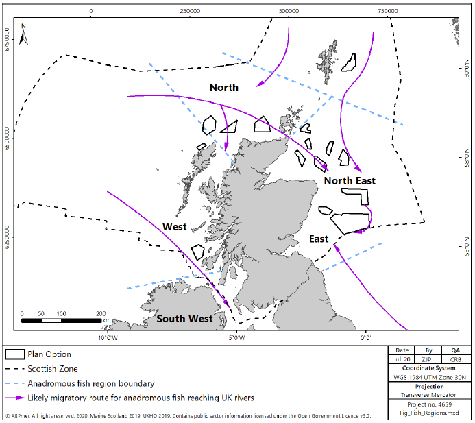
2.3.27 There is now some information on the migration paths of the outgoing salmon smolts from acoustic tagging and research trawling studies and the likely migration routes of the returning adult salmon, mainly from traditional tagging studies (Figure 45), particularly close to the coast. Outgoing smolts or returning adults are likely to migrate through all Plan Options but there remain uncertainties about the relative numbers passing through particular Plan Options.
2.3.28 Potential impacts on salmon associated with offshore wind development include those which could arise from high impact piling and detonation of unexploded ordnance during construction, possible increased predator abundance at structures, and subtle changes to magnetic fields stemming from cables conducting electricity affecting the migratory behaviour of salmon using geomagnetic cues. The salmon populations associated with each river vary in their productivity and resilience to any impacts, with some populations, but not others, able to accommodate some losses.
2.3.29 There are important fish spawning grounds around the Scottish coastline for a number of species, including herring, sandeel, cod, whiting, ling, plaice and sole[138].
Marine Mammals
2.3.30 Scotland’s ecologically rich seas support populations of a number of marine mammals and provide feeding / transit areas for further species not endemic to Scottish waters. Species of key marine mammals found within Scottish seas include:
- Grey Seal;
- Harbour Seal;
- Otter;
- Harbour Porpoise;
- Bottlenose dolphin;
- White-beaked dolphin;
- Fin whale;
- Minke whale;
- Short-beaked common dolphin;
- Atlantic white-sided dolphin;
- Risso’s dolphin;
- Long-finned pilot whale;
- Killer whale; and
- Sperm whale.
2.3.31 All the above species are PMFs.
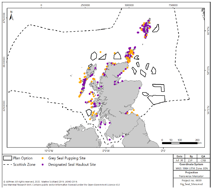
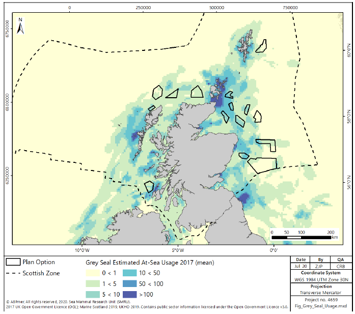
2.3.32 Marine Mammals are widely distributed around the Scottish Coastline, with species distributions a function of prey availability and habitat distribution. There is limited information with regard to the condition of cetacean populations within Scottish waters. Where the condition can be assessed the populations are assessed as favourable[141] (Harbour porpoise, bottlenose dolphin, minke whale, white beaked dolphin and fin whale). Grey seals are found widely distributed around the Scottish coastline (Figure 46 and Figure 47), with a stable but fluctuating population[142].
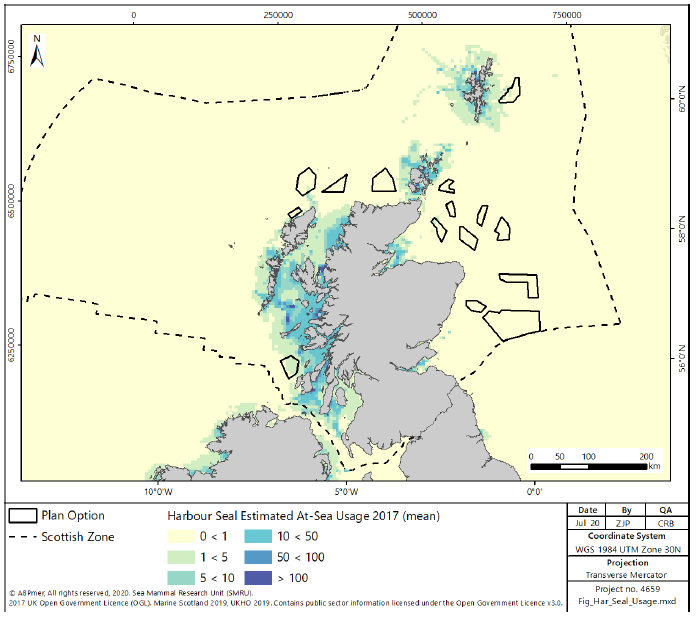
2.3.33 There has been a general decline in harbour seal numbers since 2001 in several regions of the north and east of Scotland, particularly Orkney and the Firth of Tay[143,144]. However, the patterns of decline are not universal. For example, the Moray Firth harbour seal count declined prior to 2005, remained relatively stable for four years, then increased by 40% in 2010 and has fluctuated since then, showing no significant trend since 2000[145]. 2014 and 2015 surveys have identified an increasing harbour seal population on the west coast, although east coast populations remain low[146]. Usage of Scottish seas by harbour seal (Figure 48) reflects the changes in the population distribution.
2.3.34 Otter are present around the Scottish coast, with the most recent population estimated at approximately 8,000[147]. They are protected through the designation of coastal and riverine sites throughout Scotland, with particularly significant populations on the west coast and the islands[148]. Foraging distances for otters are unknown, however they are unlikely to directly interact with the Plan Options, where water depths are greater than that commonly used by otters. There is, however, potential for interaction between otters and the location of potential cable landfalls from the Plan Options.
2.3.35 There is potential for humpback whales to be present throughout Scottish waters, with increasing records year on year[149]. It is recognised that most migrating individuals remain in deep water off the continental shelf[150] and therefore the exact distribution or number of individuals frequenting more inshore Scottish waters with potential to overlap with Plan Options remains unknown, however there are records of humpback whales in more inshore waters both on the east and west coasts[151].
Birds
2.3.36 Scotland, and its coastline, is important for marine and coastal birds, including seabirds, seaducks, divers, grebes, waders and waterfowl. Scotland provides an essential feeding station for migrating birds, a safe winter haven for ducks, geese and shorebirds, and provides nesting sites for seabird species. It holds internationally significant numbers of 24 species of breeding seabirds, with additional migratory species of waterbird overwintering on Scotland’s coasts.
2.3.37 Seabirds respond to a range of factors, such as changes in food availability, weather, predation and pollution. Breeding abundance and productivity is assessed for several species that breed in Scotland based on a representative sample of colonies around Scotland, which are monitored as part of the UK Seabird Monitoring Programme.
2.3.38 Scotland hosts large numbers of wintering seaduck, divers and grebes. Seaducks undertake surface diving to capture molluscs such as mussels and clams as well as crustacea. Divers and grebes are piscivores, preying on a variety of small fish such as clupeids, sandeel and small gadoids by undertaking pursuit diving. In addition, Scotland is important for large numbers of terrestrial species, several of which are known to migrate over long distances, including potentially over areas of sea that are included as part of the Plan Options.
2.3.39 Important populations of other wintering and passage waterbirds are recorded in estuaries and sheltered coastal sites in Scotland. Some of these sites lie on major migratory flyways for both seabirds and terrestrial species, and in spring and autumn birds utilise the area as a staging post during onward migration to wintering grounds.
2.3.40 White tailed sea eagles have in recent years been re-introduced to Scotland, and a breeding population has established on the west coast and in the Western Isles. Sea eagles, particularly juveniles, are known to travel widely, and therefore have the potential to transit through the Plan Option areas.
2.3.41 As discussed in Section 2.3 above, there are 58 SPAs established under the Birds Directive in Scottish waters to conserve bird species or assemblages of international importance.
2.3.42 Scotland’s Marine Atlas[152] reported that seabird populations are increasing in some areas (Solway Firth and the Firth of Clyde, for example) and decreasing in others for certain species. In East and West Shetland and along the North Scotland coast, this decrease is most probably related to a shortage of prey species resulting from changes in oceanographic conditions. Like seabirds, waterbirds (wildfowl and waders) are also both increasing and decreasing year on year, depending on the species and location. The reasons for the changes remain to be fully explained but may in part be due to redistribution of wintering birds across northwest Europe due to climate change effects.
2.3.43 A more recent assessment of seabird trends between 1986 and 2016 found that the mean numbers of 12 species of breeding seabirds in Scotland had declined by 62% compared to the 1986 baseline level[153]. Out of the 12 species assessed for breeding numbers, Arctic skua had experienced the largest declines (77%). The Northern Isles are their key breeding area and there have been declines in the availability of sand eels, which they obtain from other seabirds, such as kittiwake, by chasing them to make them release their food. Similar patterns of decline have occurred for the species they parasitise, particularly kittiwakes and terns. Increased predation from great skua has also been linked to their decline. Some species trends, although less prominent, appear to be stabilising possibly at a new level which differs from the 1986 baseline. Numbers of common terns increased in 2016, which may reflect a rapid response to favourable breeding conditions.
2.3.44 The assessment found that seabird breeding productivity between 1986 and 2016 varied for the 12 species analysed. Breeding success in 2016 was above the long-term average for Arctic tern; black-legged kittiwake; common tern; little tern; northern gannet and Sandwich tern. Great skua and herring gull had lower breeding success. All other species were around the long-term average.
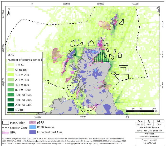
2.3.45 The European Seabirds At Sea database data (Figure 49) highlights the areas of high bird sightings which can be used as an indicator of high bird density. Areas on the east coast in the Moray Firth and Firth of Forth are of particular importance, alongside some areas around the Hebrides, Orkney and Shetland Islands. Whilst this data gives a good indication of the seabird density, there is likely to be bias in the reporting based on the effort in an area, (this can be seen on Figure 49 where some areas of higher densities correlate with higher shipping densities, discussed in Section 2.2 above, indicating greater effort).
Cultural Heritage
2.3.46 Scotland’s coastal and marine environments are rich in cultural heritage. There are many scheduled monuments and listed buildings clustered along the coast, with designated wrecks and military remains identified offshore. Key coastal features include several Category A listed lighthouses, ecclesiastical remains, military defences, forts and castles. Two of Scotland’s World Heritage Sites (St. Kilda and the Heart of Neolithic Orkney) are on the coast, with other non-Scottish sites (including Hadrian’s Wall in England and the Giant’s Causeway in Northern Ireland) on adjacent coastlines.
2.3.47 Within Scottish waters there are a number of marine sites, designated as Historic MPAs, which are considered to contain marine historic assets of national importance. All Historic MPAs are designated within Scottish Territorial Waters (up to 12 nautical miles (nm)) and are shown in Figure 50.
2.3.48 Sea level rise, on historic timescales has changed the position of the coastline of the United Kingdom considerably in the time since hominid occupation of the United Kingdom is first known to have occurred. As areas of land became submerged, any artefacts in this area were submerged with it, and therefore there is potential for culturally significant artefacts to be in the subtidal areas around Scotland. The largest areas of land which have been submerged are in the southern North Sea and the English Channel[154], although there are areas around the coast of Scotland, including in the Firth of Forth and Aberdeenshire coastlines, which were previously above sea level (Figure 51).
2.3.49 There is therefore potential for submerged archaeological remains in these areas. Except for some areas in the North East and East regions, and an area in the Shetland region, these potential areas are inshore of the Plan Options, and therefore the impacts of development on these areas are limited to infrastructure associated with cable landfalls. The likelihood of archaeological remains is, however, difficult to quantify on a regional scale, due to the small areas of archaeological interest (potentially in the scale of metres) associated with hominid occupation[155] and therefore it is expected that consideration would have to be made at a project level to manage the impacts of cable landfalls and offshore wind farm development.
2.3.50 Further areas of potential historic importance including shipwrecks, which are common and widely distributed around the Scottish coast, shown in Figure 52, may be known on a regional scale, where data is available this will be considered within the regional discussions below.
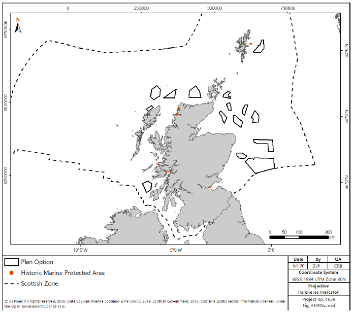
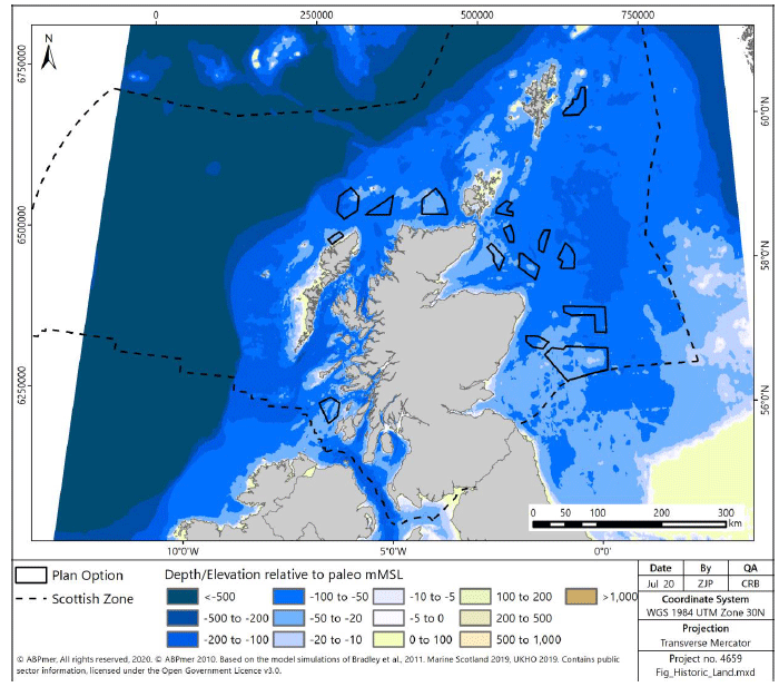
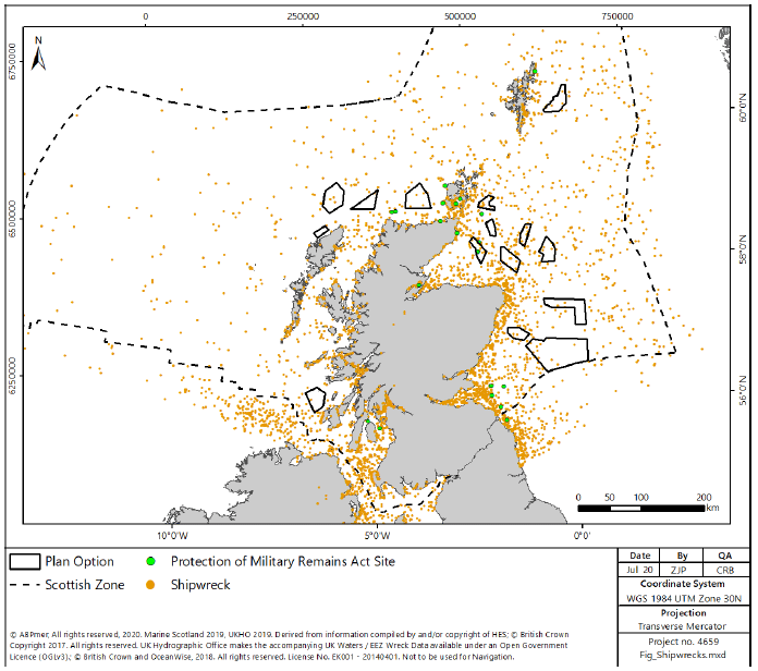
Landscape / Seascape
2.3.51 Scottish Natural Heritage (SNH) has undertaken an assessment of the landscape and seascape of Scotland, developing the Landscapes of Scotland map[157], dividing Scotland into 79 areas, each of which has a description of the landscape and seascape within that area.
2.3.52 There are 40 National Scenic Areas (NSAs), defined as areas of outstanding scenic value in a national context, which are protected for their value in aesthetic and landscape terms (Figure 53). Of the 40 NSAs, many have coastal elements, the characters of which are defined in the rationale for selection[158]. The NSA designations are integrated into Scottish Planning Policy, whereupon any development with the potential to affect an NSA should only be permitted where:
- the objectives of the designation and the overall integrity of the NSA won’t be compromised; or
- any significant adverse effects on its special qualities are outweighed by social, environmental or economic benefits of national importance.
2.3.53 In addition, SNH have identified 42 Wild Land Areas (WLA) which describe the most extensive areas of high wildness. It is not a statutory designation, but wild land areas are considered nationally important[159]. The WLA, presented in Figure 54, introduce a requirement under Scottish planning policy[160] to demonstrate that any significant effects on the qualities of these areas can be substantially overcome by siting, design or other mitigation.
2.3.54 Scott et al, (2005)[161], developed a methodology to characterise seascapes, and define their sensitivity to offshore wind. The sensitivity of the seascapes is increased where there is greater intricacy, stillness, low lighting and where the seascape is currently unmodified and experienced from a secluded coastline. The distance to which offshore windfarms can be seen is also discussed, identifying maximum visual ranges of 40 to 50km, although assessments within the report were based on a visual range of 35km.
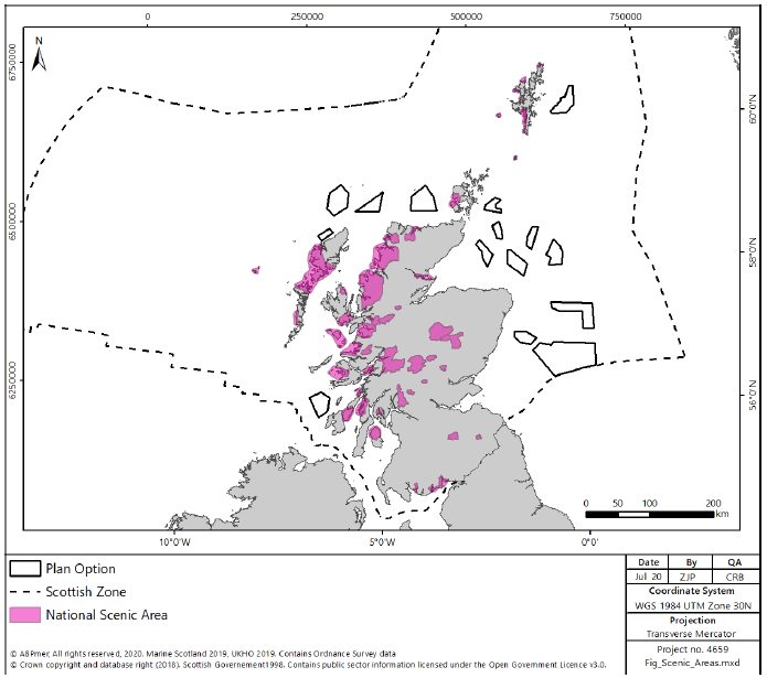
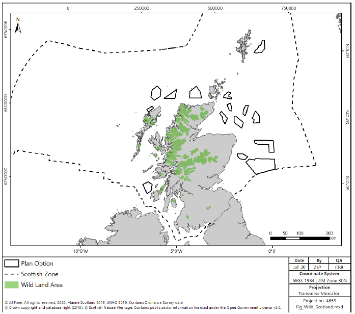
2.4 Planning Issues
2.4.1 National, city-region and local development plans aim to strike an appropriate balance between supporting sustainable economic growth and protecting and enhancing quality of life and the environment.
Offshore Wind
2.4.2 The outcome of the RLG and subsequent development of the Offshore Wind Plan will provide guidance and direction for future development of the offshore wind industry in Scotland.
2.4.3 The consenting process for offshore wind, through the marine licencing process, will consider the potential economic and environmental impacts of a development. In addition, there is a requirement to consider cumulative impacts associated both with other offshore wind and other sector developments (oil and gas, CCS etc.).
2.4.4 The development of a well considered plan for offshore wind should reduce the burden placed on the consenting process and allow a smoother route for appropriate developments.
Onshore Development
2.4.5 To realise the economic potential of Scottish offshore wind resources, not only will the offshore development projects have to progress through the consenting process, associated infrastructure will also need to be developed within Scotland under the terrestrial planning system. To encourage the realisation of opportunities within Scotland the National Renewable Infrastructure Plan (NRIP) was developed, which identifies the extent of investment required in three broad geographic manufacturing clusters- Forth / Tay, Moray Firth and West Coast; and a subsea operations and maintenance cluster – Aberdeen / Peterhead.
2.4.6 The NRIP has subsequently fed into the development of the National Planning Frameworks, now at revision 3 (NPF3) which contains high level planning policy. NPF3 presents a strategy for the future development of Scotland, expressing the Scottish Government’s economic strategy and planning for infrastructure investment. In line with this, it is expected that local policy development and planning decisions should take note of its contents and support its delivery.
2.4.7 Whilst the development of the NPFs has shown consideration to the direction of development, it has been identified that there has been limited success in the delivery of the infrastructure developments, and therefore Scottish Government is currently undertaking to promote a Planning Bill to drive forward the delivery and implementation of the NPF through increased emphasis on local development plans[162].
2.4.8 A key infrastructure requirement for the development of offshore wind is the enhancement of the electricity grid to transport the generated electricity from source to where it is required. These enhancements, both within the marine and terrestrial environments, will require further planning and marine consents. The Electricity Ten Year Statement[163] identifies the currently planned expansions to the grid, however it is likely that these plans would need further enhancement to integrate significant offshore wind development in the future.