Sectoral Marine Plan: roadmap of actions
Road map of actions required to improve our understanding of the potential implications of ScotWind sites on seabirds as identified by the Sectoral Marine Plan.
Appendix 1 Research priorities for each Plan Option Area
A1.1. W1
The SMP SEA concluded that the residual effect on key receptors following the construction of wind farms within W1 was likely to be minor negative – moderate negative (Figure 9). Accordingly, whilst no ornithological constraints were identified in relation to this site, uncertainties remained in relation to the potential for displacement of seabirds from key foraging areas, and the potential collision risk associated with migrating waterbirds, particularly Whooper Swans and the geese which are designated features of SPAs on Islay and Colonsay.
The ongoing strategic review of migration and development of a migratory sCRM funded by the Scottish Government will help to reduce uncertainty surrounding the risk to migrants in this PO.
Further work is needed to assess the potential consequences of displacement and barrier effects in PO W1 for common guillemot, razorbill Alca torda and kittiwake. Analysis of GPS tracking data collected from Colonsay by the RSPB as part of the FAME/STAR Programme highlights potential overlap between foraging areas of birds from the North Colonsay and Western Cliffs SPA and PO W1 (Thaxter et al., 2019). Whilst not specific to PO W1, workshop participants highlighted the value of carrying out studies to reduce uncertainty surrounding the energetic costs of displacement and barrier effects on breeding seabirds [OUTPUT], such as the analysis of GPS data to identify foraging and commuting areas [ACTION].
A1.2 N1
The SMP SEA concluded that the residual impact on key receptors following the construction of wind farms within N1 was likely to be minor negative – moderate negative. Whilst the proximity of the PO to Sule Skerry and Sule Stack SPA (Figure 10), and SPAs on Orkney, means there is high connectivity with parts of the PO by species including kittiwake, gannet and auks (see also Waggitt et al., 2019), careful marine spatial planning could help avoid high usage areas. However, workshop participants also highlighted the presence of nocturnally active species, such as Manx shearwater and European storm-petrel Hydrobates pelagicus (Waggitt et al., 2019) which may not be reliably detected by survey methodologies such as digital aerial survey, as a key source of uncertainty within this PO.
Workshop participants highlighted that the key to reducing uncertainty in relation to this PO was getting a better understanding of species distributions, and connectivity with SPA populations [ACTION]. GPS tracking data are available to assess connectivity for designated features of some of these SPAs (Wakefield et al., 2013, 2017), more data are required for others. The availability of lightweight GPS devices means that it is now possible to collect data on some of the smaller species that may be present within the PO, such as European storm-petrels (Bolton, 2021) from Sule Skerry and Sule Stack SPA. This is particularly important given that these species may be nocturnally active, and so less well covered by traditional surveys (Deakin et al., 2022). Workshop participants highlighted the need to assess the potential risk to these species within these POs and, if determined to be at risk, the potential for them to be detected by digital aerial survey and, for digital aerial survey to distinguish between smaller species with similar appearances, such as European storm-petrel and Leach's petrel Oceanodroma leucorhoa.
Workshop participants highlighted that development within this PO was likely to result in interactions with offshore wind farms involving species such as Manx shearwater and European storm-petrel, which have not been an important feature of offshore wind farm EIAs to date. As nocturnally active species, particular concerns were noted in relation to the potential for birds to be attracted to turbine lighting with a review of this topic highlighted as a research need to reduce the uncertainty associated with this. Secondly, ongoing GPS tracking studies of Manx shearwater in the Irish Sea region, where there are several existing offshore wind farms, were highlighted. Further analysis of these data may offer insights into how the species is likely to respond to developments within this PO [ACTION], and may help also help reduce uncertainty in relation to parameters such as flight height and speed [OUTPUT], which are important for collision risk modelling (Masden et al., 2021).
A1.3 N2
The SMP SEA concluded that the residual effect on key receptors following the construction of wind farms within N2 was likely to be negligible – minor negative. Whilst the PO is close to North Rona and Sula Sgeir SPA (Figure 11), overall bird usage of this area is believed to be low (see also Waggitt et al., 2019), and water depth means that it is unlikely to be a core foraging area. However, key uncertainties remain in relation to the potential impact on migrating birds. These are likely to be reduced by the ongoing strategic review of collision and development of a migrant collision risk modelling tool. Workshop participants highlighted uncertainties relating to nocturnally active species present in the area such as Manx shearwater and European storm-petrel. The work required to reduce these uncertainties includes a review of the potential impact of turbine lighting on these species (which may be inferred from responses to vessels or other sources of light) [ACTION], and an analysis of existing GPS tracking data from Manx shearwater in the Irish Sea region [ACTION] to better understand how the species may respond to offshore wind farm development within this PO.
A1.4 N3
The SMP SEA concluded that the residual effect on key receptors following the construction of wind farms within N3 was likely to be negligible – moderate negative. Whilst bird usage of the area is generally considered to be low (see also Waggitt et al., 2019), there are important populations present within the North Rona and Sula Sgeir SPA (Figure 12). These include both Leach's Petrel and European storm-petrel, which have not yet been widely considered as part of impact assessments for offshore wind farms. Consequently, there is considerable uncertainty surrounding the potential impacts on these species, exacerbated by the fact they are nocturnally active, are not well covered by traditional survey methods, and their population sizes and population trends are highly uncertain. There are also uncertainties relating to the potential impacts on migratory waterbirds.
The presence of both Leach's petrel and European storm petrel within the vicinity of this PO raises uncertainty in relation to potential offshore wind impacts on populations of these species. The availability of lightweight GPS devices means that it is now possible to collect GPS data on these species from the North Rona and Sule Sgeir SPA [ACTION]. This may be important given that these species may be nocturnally active, and so less well covered by traditional surveys. Consequently, analyses of these data should include a comparison of distributions during conditions in which surveys can and cannot be completed (e.g. Thaxter et al., 2019). Furthermore, workshop participants highlighted the need to gain a clearer understanding of how well approaches such as digital aerial survey could distinguish between smaller species with similar appearances, as European storm petrel and Leach's storm petrel [ACTION].
Reflecting the likely presence of nocturnally active species within the PO, developments would benefit from a review of the impact of lighting on these species, and other procellariforms [ACTION]. In may also be possible to reduce uncertainty relating to potential impacts on Manx Shearwater through analysis of existing GPS tracking data from the Irish Sea region [ACTION].
A1.5 N4

The SMP SEA concluded that the residual effect on key receptors following the construction of wind farms within N4 was likely to be negligible – minor negative. Bird usage of the area is likely to be low (see also Waggitt et al., 2019), though there is the potential for interactions with breeding seabirds from the Flannan Isles and Shiant Isles SPAs (Figure 13). There is also uncertainty surrounding potential interactions with migratory species, particularly whooper swan.
Uncertainties surrounding potential impacts on migratory species will be reduced by the ongoing strategic review of migration and development of a migrant collision risk tool. As Leach's petrel is a feature of the Flannan Isles SPA, a review of the potential for lighting to attract nocturnally active species [ACTION] would be of benefit in relation to this PO.
A1.6 NE1
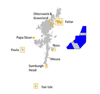
The SMP SEA concluded that the residual effect on key receptors following the construction of wind farms within NE1 was likely to be negligible – moderate negative. Whilst bird usage of the area is generally low (see also Waggitt et al., 2019), there are a number of important seabird populations within Shetland SPAs, such as the Sumburgh Head SPA and Fair Isle SPA (Figure 14). These include populations of species such as great and Arctic skua which have not been an important feature of impact assessments for offshore wind farms to date. Furthermore, there is uncertainty about the potential for migratory birds interact with this PO. Workshop participants also highlighted the potential for nocturnally active species, such as European storm petrel to be present within this PO.
The water depth within this PO is in excess of 100 m throughout. Consequently, it is unlikely to be a key seabird foraging area. Under a realistic maximum development scenario, up to 53% of this PO would be developed. There is a need to carry out surveys of this PO in its entirety [ACTION] to confirm that bird density within the PO is low, and to determine the optimal distribution of turbines [OUTPUT] whilst minimising environmental impacts. For species such as gannet and kittiwake, which are suspected to be sensitive to the impacts associated with offshore wind farms, and for which predicted cumulative impacts are approaching levels of concern (Busch & Garthe, 2017), GPS tracking studies may prove valuable as a means to determining the behaviour of birds within the PO and identify key commuting routes between breeding colonies and foraging areas [ACTION]. Whilst not a key ornithological constraint, GPS tracking of gannets from the Fair Isle SPA would be valuable for establishing potential connectivity with this PO [ACTION].
Given water depths within this PO, any development is likely to involve floating turbines. Through careful marine spatial planning, these can be positioned to avoid areas of highest bird densities. This should carefully consider factors such as the potential impact of turbine spacing on displacement rates [OUTPUT]. However, the use of floating turbines may also enable a more adaptive management approach to be used. It may be possible for turbines in an array to be moved in response to post-construction monitoring data to reduce the impact associated with the development. A review of the practicalities of post-construction mitigation measures such as this would be beneficial for reducing some of the uncertainties associated with development in this PO [OUTPUT].
At present, collision risk models have been developed for use with fixed turbines with hub heights measured relative to highest astronomic tide. It will be important to consider how to adapt guidance for use with floating turbines which will remain a constant height above sea-level. Where flight height estimates are based on survey data, these will reflect height above the sea surface, and may be directly transferable to the assessment of collision risk at floating turbines. However, where flight heights have been measured using GPS data, these are likely to be aggregated and reflect height above mean sea-level rather than the height above the sea surface experienced by the birds. Adapting these data for collision risk modelling will require careful consideration. This may also have implications for assessing the efficacy of raising turbine hub height as a mitigation measure for reducing collision risk [OUTPUT].
Whilst not presently a key ornithological constraint, there is uncertainty surrounding the potential for cumulative impacts on gannets from the Noss and Fair Isle SPAs given the potential for birds to interact with multiple POs. A cumulative impact assessment of the potential impacts of the POs on these populations [OUTPUT], for example incorporating methods and approaches available as a result of the CEF [ACTION], will be valuable to reduce this uncertainty.
Given the potential presence of nocturnally active species, such as European storm petrels, within the PO, a review of the potential for turbine lighting to attract these species [ACTION] may be valuable.
A1.7 NE2 and NE3
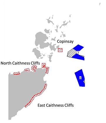
The SEA for the SMP considered bird usage of NE2 and NE3 was likely to be low (see also Waggitt et al., 2019). However, the proximity of the PO to the Copinsay SPA, East Caithness Cliffs SPA and North Caithness Cliffs SPA (Figure 15), for which kittiwake is a designated feature, and the predicted cumulative impacts of offshore wind developments on the east coast and Orkney kittiwake population more generally, means that the residual effect of NE2 and NE3 was assessed as minor negative – major negative. Reflecting this, the SMP HRA concluded that an Adverse Effect on Site Integrity was likely to arise as a consequence of developments within NE2 and NE3 in combination with existing and consented offshore wind farms in the Moray Firth. As a result, NE2 and NE3 was identified as being subject to higher levels of ornithological constraint, meaning that development within these POs cannot take place until such time that enough evidence on the environmental capacity for seabirds exists to reduce the risk to an acceptable level. This assessment is based on currently predicted levels of impact but, if evidence is presented that would enable these impacts to be revised downwards, it may be possible for development to proceed.
The key to unlocking offshore wind potential within these POs will be reducing uncertainty in existing assessments with a view to obtaining evidence that would enable more accurate estimation of impacts. Workshop participants highlighted three key routes to achieving this:
1) Reduce uncertainty surrounding the magnitude of the predicted cumulative impacts of collision and displacement within offshore wind farms in the Moray Firth [OUTCOME]
2) Reduce uncertainty surrounding the predicted population level effects of offshore wind farms in the Moray Firth [OUTCOME]
3) Reduce uncertainty surrounding the distribution of birds in NE2 and NE3 [OUTCOME]
A1.7.1 Reduce uncertainty surrounding the magnitude of the predicted cumulative impacts of collision and displacement within offshore wind farms in the Moray Firth
The first step to unlocking offshore wind potential within POs NE2 and NE3 will be to reduce the uncertainty surrounding the magnitude of predicted cumulative impacts of collision and displacement within offshore wind farms in the Moray Firth. This can be achieved in two ways. Firstly, by intensive and robust monitoring of constructed sites and revising the impacts predicted within EIAs based on observed impacts [OUTPUT]. Given the challenges of collecting data on collisions in the offshore environment, this is likely to be of most relevance to displacement. Secondly, by revision to model input parameters from those originally used in the AA to any that have been subsequently revised using the CEF [OUTPUT]. This relates to both collision, where models are sensitive to parameters such as avoidance, flight height and speed (Chamberlain et al., 2006; Masden et al., 2021), but also to displacement, where predicted impacts are sensitive to assumptions surrounding energetics and mortality rates (Busch & Garthe, 2016; K Searle et al., 2018).
The key focus within NE2 and NE3 relates to kittiwake. Evidence relating to kittiwake displacement from existing offshore wind farms is equivocal, ranging from weak attraction to weak displacement (Dierschke et al., 2016). Intensive and robust monitoring of the Beatrice and Moray East offshore wind farms, and analysis of the resulting data [ACTION], will enable a comparison of the observed proportion of birds displaced with that predicted in the EIA. This will help to reduce the uncertainty surrounding the proportion of birds displaced by the existing wind farms in the Moray Firth. This must be combined with work to reduce uncertainty in the demographic consequences of displacement [OUTPUT], for example by better quantifying the link between the energetic costs of foraging, survival, and productivity [OUTPUT] (e.g., using IBMs such as SeabORD and critically the collection of GPS and demographic data [ACTION] to assist in improving the parameterization and validation of these processes within IBMs). Such analyses may unlock potential within NE2 and NE3 by reducing uncertainty surrounding the predicted cumulative impact of displacement associated within offshore wind farms within the Moray Firth.
Given the proximity of NE2 and NE3 to the Copinsay SPA, the cumulative impact of collision risk of kittiwake is of concern. At present, models of collision risk rely on generic sources of data for key parameters including avoidance rates (Cook, 2021, 2014), flight speed (Alerstam et al., 2007) and flight heights (A. Johnston et al., 2014). However, such data are often derived from limited sample sizes and/or in a specific set of conditions. Furthermore, these values may differ according to whether birds are engaged in commuting or foraging flight (Thaxter et al., 2019). Analyses of new and existing GPS data can serve to reduce uncertainty surrounding some of these parameters, and in turn reduce uncertainty surrounding predicted collision rates [OUTPUT] (Masden et al., 2021). Ideally, these data should be collected on a site-specific basis, e.g., high resolution GPS tracking data from kittiwake within the Copinsay SPA [ACTION].
The availability of flight height estimates from a variety of platforms results in considerable uncertainty in relation to the available datasets. These datasets are likely to be subject to multiple sources of bias, error, and uncertainty. In the absence of a multi-sensor study with flight height estimates made concurrently from different technologies [ACTION], it is unclear how comparable estimates from these datasets are. Such a study would be of considerable value in relation to reducing uncertainty surrounding species flight height estimates [OUTPUT].
Having revised the input parameters for the collision risk model, there may be the potential to reduce uncertainty in estimated collision rates through revisions to the model itself. At present, uncertainty in collision estimates due to "model simplification" is believed to be in the range of 20% (Band, 2012). Whilst the sCRM accounts for uncertainty in the model input parameters, it does not account for uncertainty resulting from model simplification (McGregor et al., 2018). Recent analysis by Masden et al. (2021) highlights how the estimation of the probability of collision (PColl) and flux rate can influence estimated collision rate. However, neither PColl nor flux have been validated, contributing to uncertainty. There is a need to consider how these can be validated, potentially in conjunction with consideration of alternative models such as the Flux Collision Model [OUTPUT] (Kleyheeg-Hartman et al., 2018).
Having updated both the models and input parameters used to assess collision and displacement, revising the estimated cumulative impacts, using the CEF [ACTION], associated with offshore wind farms in the Moray Firth will help reduce uncertainty surrounding predicted impacts and may help unlock offshore wind potential within NE2 and NE3.
A1.7.2 Reduce uncertainty surrounding the predicted population level effects of offshore wind farms in the Moray Firth
At present, the population level consequences associated with offshore wind farm development are typically assessed using a Leslie Matrix Model with a simplistic set of assumptions, including a closed population and no density dependence. Reflecting the consenting risks highlighted in the SMP SEA, the focus for such studies in relation to POs NE2 and NE3, workshop participants highlighted the value of developing a meta-population model for the Orkney and east coast kittiwake population [OUTPUT]. Such a model should factor in links between effects and demography at the individual level, incorporate key processes at the population level such, as density dependence and net movements between colonies, and incorporate the impact of other pressures on demography where possible. This requires collating and collecting demographic data on a colony-specific basis [ACTION]. Where colony-specific data are not available, this model should be based on the best available data (e.g. Horswill et al., 2021), and refined as new data become available. The use of data which are not colony-specific should be seen as a temporary solution, and development of the model should not be at the expense of key data collection.
Horswill et al., (2018) and O'Hanlon et al. (2021) highlight that whilst a minimum of 10 years data are required to estimate reliable survival rates, the uncertainty surrounding these rates can be narrowed with five years of data. Reflecting the priorities associated with NE2 and NE3, demographic data collection for a meta-population model in relation to these POs should focus on the kittiwake population within the North Caithness Cliffs SPA, East Caithness Cliffs SPA and Copinsay SPA [ACTION]. It may also be possible to use novel approaches such as Motus type tracking to monitor return rates and increase the recapture probability of these birds, potentially, reducing the time required to obtain robust survival estimates. A feasibility study for this approach (potentially captured in an OWEC funded MOTUS study), and other remote methods for demographic data collection, would be valuable [ACTION].
Using this model to assess the cumulative impact of existing and consented wind farms on the east coast of Scotland would help to reduce uncertainty surrounding the predicted population-level consequences of these wind farms and may help unlock offshore wind potential within NE2 and NE3.
A1.7.3 Reduce uncertainty surrounding the distribution of birds in NE2 and NE3
Modelled distributions for key species, including kittiwake, should be produced from survey data for each Option Agreement. Ideally these models should incorporate GPS tracking data from kittiwakes within the North Caithness Cliffs SPA, East Caithness Cliffs SPA and Copinsay SPA [ACTION] to better apportion impacts arising from offshore wind developments within NE2 and NE3 back to the SPAs [OUTPUT] during the breeding season. These data would also help to identify key foraging and commuting areas for kittiwake [ACTION] (e.g. Thaxter et al., 2019), which would be of value in relation to identifying areas where birds may be particularly vulnerable to displacement. Given the potential for annual variation in foraging areas between years, it is important that such data are collected over multiple years, and to better understand distributions in relation to oceanographic and ecosystem conditions [OUTPUT].
Survey data suggest usage of these POs by vulnerable species including gannets, common guillemot, razorbill and kittiwake during the winter may be relatively high, though there is some uncertainty surrounding this (Waggitt et al., 2019). Geolocation studies suggest that some of the auks may originate from Scottish east coast SPAs (e.g. Dunn et al., 2020; St. John Glew et al., 2019, 2018). To address this, as highlighted above, there is a need for survey data from the POs in their entirety [ACTION]. To improve the apportioning of impacts outside the breeding season [OUTPUT], there is a need to collect geolocation data from gannets, common guillemot, razorbill, and kittiwake from Scottish east coast SPAs [ACTION], and consider how these data can be combined with survey data [ACTION]. Given the resolution of data from geolocation data, there is a need to consider how these can be refined and, in the case of larger species such as kittiwake and gannet, whether it is possible to develop methodologies for the longer-term deployment of GPS tags [ACTION] on these species. To better understand the energetic consequences of displacement [OUTPUT] outside the breeding season, TDRs should be deployed alongside these devices [ACTION] to assess time-activity budgets.
Given the high level of ornithological constraint associated with the kittiwake population on Orkney and the Scottish east coast, in addition to using careful marine spatial planning to reduce impacts, there is a need to consider effective mitigation options. These may include increasing turbine spacing to mitigate the impact of displacement or raising turbine hub heights to reduce the number of birds at collision risk height. Assessing the efficacy of these, and other, mitigation options will require the analysis of robust data collected as part of monitoring at existing wind farms. It is also likely to require some inferences to be made in relation to the efficacy of different options [OUTPUT]. For example, at present, we do not have data to measure whether raising turbine hub height reduces the number of collisions. However, we would be able to compare flight heights inside and outside [OUTPUT] operational wind farms using approaches such as GPS tagging, LiDAR, radar, and digital aerial survey. This will offer an indication of how pre- and post-construction flight heights may compare, and therefore, how effective raising turbine hub height may be in terms of reducing the number of birds at risk of collision [OUTPUT].
A1.7.4 Other uncertainties
Whilst not currently constraints to development within NE2 and NE3, the SMP SEA and workshop participants also highlighted uncertainty in relation to several other issues. Firstly, as with NE1, there is uncertainty surrounding the potential for interaction between gannets from the Fair Isle, Noss and other SPAs and POs NE2 and NE3. Consequently, there is also uncertainty surrounding the potential for cumulative impacts on these gannet population in relation to the POs, existing and consented offshore wind farms in the Moray Firth. GPS tracking of birds from these SPA populations [ACTION] would help reduce uncertainty surrounding the connectivity between the SPA and NE2 and NE3, and a strategic cumulative impact assessment for gannets from these SPAs, beyond that which would be expected in relation to individual developments [OUTPUT], would help to address questions relating to the population level consequences of existing and planned wind farms in the Moray Firth.
In addition to uncertainty surrounding the potential for negative impacts on gannets from the Fair Isle SPA, there is also uncertainty surrounding the potential for significant negative effects on migrating birds. Furthermore, workshop participants also highlighted the potential presence of nocturnally active species such as European storm petrel within the POs. Whilst the ongoing strategic review of migration and development of a migrant collision risk tool is likely to reduce uncertainty surrounding impacts on migrant species, and a review of the impact of turbine lighting on nocturnally active species [ACTION] would be beneficial in terms of reducing uncertainty within these POs.
A1.8 NE4 and NE6
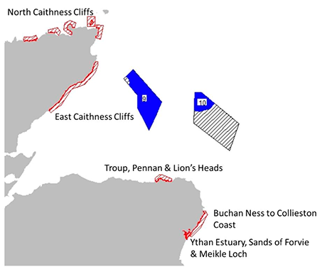
The SEA of the SMP considered that bird usage of NE4 and NE6 was likely to be high, and likely to include foraging birds from the East Caithness Cliffs SPA (Figure 16). Consequently, the SMP SEA assessed potential impact of POs NE4 and NE6 as minor negative – major negative. Reflecting this, the SMP HRA concluded that an Adverse Effect on Site Integrity was likely to arise as a consequence of developments within NE4 and NE6 in combination with existing and consented offshore wind farms in the Moray Firth. As a result, NE4 and NE6 were identified as being subject to higher levels of ornithological constraint, meaning that development within these POs cannot take place until such time that enough evidence on the environmental capacity for seabirds exists to reduce the risk to an acceptable level. This assessment is based on currently predicted levels of impact but, if evidence is presented that would enable these impacts to be revised downwards, it may be possible for development to proceed.
Given the potential for adverse impacts on populations of kittiwake within the North Caithness Cliffs SPA and East Caithness Cliffs SPA, as with NE2 and NE3, the key to unlocking offshore wind potential within these POs will be reducing uncertainty in existing assessments. Consequently, the projects highlighted in relation to NE2 and NE3 to reduce uncertainty in relation to the predicted impacts of collision and displacement, reduce uncertainty surrounding predicted population level effects [ACTION], and reduce uncertainty surrounding the distribution of birds within POs [ACTION], are also of relevance here.
Whilst GPS tracking data suggest minimal overlap in foraging areas for common guillemot and razorbill from the East Caithness Cliffs SPA (Wakefield et al., 2017), there is uncertainty over the potential for great black-backed gulls, also a feature of the East Caithness Cliffs SPA, to make use of these POs. Consequently, GPS tracking of great black backed gulls from the East Caithness Cliffs SPA to establish the extent of any connectivity between the SPA and POs NE4 and NE6 would be valuable. This is a license condition for existing Moray Firth wind farms where concerns over the potential for tag effects are a constraint for delivery. Consequently, careful liaison with the Special Methods Technical Panel of the BTO ringing committee will be required in order to deliver this work. Similarly, workshop participants highlighted uncertainty over connectivity between gannets from Fair Isle and these POs, while the SMP HRA also highlights the potential for kittiwakes from the Troup, Pennan and Lion's Heads SPA to interact with NE6. GPS tracking of these populations [ACTION] would be valuable to assess the extent of any connectivity with NE4 and NE6. Ideally, in all cases, any tracking should be complemented by surveys of both POs as a whole [ACTION] to better understand space use within the POs, and more accurately apportion impacts back to SPA populations [OUTPUT].
As with NE2 and NE3, there is a need to collect data using geolocators from key seabird species [ACTION] on the Scottish east coast to improve apportioning outside the breeding season. Alongside this, TDR data should be collected [ACTION] to better understand the energetic consequences of displacement [OUTPUT].
As with other POs, the SMP SEA highlighted the potential for significant negative effects on migrating birds, while workshop participants also highlighted the potential presence of nocturnally active species such as European storm petrel within the PO. Whilst the ongoing strategic review of migration and development of a migrant collision risk tool is likely to reduce uncertainty surrounding impacts on migrant species, an assessment of the ability to distinguish between Leach's petrel and European storm petrel, and a review of the impact of turbine lighting on these species [ACTION] would be beneficial in terms of reducing uncertainty within this PO. However, such projects would be of a lower priority than those highlighted above in relation to gannets, kittiwakes, and great black-backed gulls.
A1.9 NE7 and NE8
Whilst POs NE7 and NE8 are not subject to a high level of ornithological constraint, impacts on the SPAs shown here mean that other POs within this region are subject to a high level of ornithological constraint.
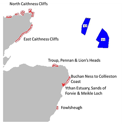
The SMP SEA concluded that the residual effect on key receptors following the construction of wind farms within NE7 and NE8 (Figure 17) was likely to be minor – moderate negative. Analysis of GPS tracking data suggests bird usage of the area is likely to be low (Wakefield et al., 2017). However, the potential for negative effects in-combination with other east coast projects is acknowledged. The SEA also highlights the potential for negative impacts associated with birds migrating from Scandinavia.
Data from surveys and tracking studies indicate that seabird usage of these POs during the breeding season is likely to be low (Waggitt et al., 2019; Wakefield et al., 2017), and, for most species, they are beyond the foraging ranges of key breeding colonies (Woodward et al., 2019). However, there is substantial uncertainty surrounding the distribution of birds within these POs outside the breeding season (Waggitt et al., 2019), particularly during migration periods for species like skuas, and over winter for species like auks. Reducing this uncertainty will require surveys of the POs as a whole [ACTION]. Ideally, these data would be combined with geolocation data collected from auk populations [ACTION] on the east coast to help improve the apportioning of impacts outside the breeding season [OUTPUT].
Given the water depths in these POs, developments are likely to involve floating turbines. At present, collision risk models have been developed for use with fixed turbines with hub heights measured relative to highest astronomic tide. It will be important to consider how to adapt guidance for use with floating turbines which will remain a constant height above sea-level. Where flight height estimates are based on survey data, these will reflect height above the sea surface, and may be directly transferable to the assessment of collision risk at floating turbines. However, where flight heights have been measured using GPS data, these are likely to be aggregated and reflect height above mean sea-level rather than the height above the sea surface experienced by the birds. Adapting these data for collision risk modelling will require careful consideration. This may also have implications for assessing the efficacy of raising turbine hub height as a mitigation measure for reducing collision risk [OUTPUT].
As with other POs, the SMP SEA highlighted the potential for significant negative effects on migrating birds, while workshop participants also highlighted the potential presence of nocturnally active species such as European storm petrel within the PO. Ongoing strategic review of migration and development of a migrant collision risk tool is likely to reduce uncertainty surrounding impacts on migrant species. However, an assessment of the ability to distinguish between Leach's petrel and European storm petrel, and a review of the impact of turbine lighting on these species [ACTION] would be beneficial in terms of reducing uncertainty within this PO.
A1.10 E1 and E2
The SMP SEA suggests that the offshore nature of POs E1 and E2 (Figure 18) mean that they are likely to be areas of lower bird density. Consequently, the SMP SEA considered the likely impact of these POs on designated features of protected sites to be minor negative – moderate negative. However, the SMP HRA highlights the potential for significant negative impacts as a result of the number of built, consented, and planned developments within the region, and the number of important breeding seabird breeding colonies within foraging range. Furthermore, historic data presented in Waggitt et al. (2019) suggests densities may be higher outside the breeding season, though there are uncertainties about these densities. Consequently, the SMP HRA advised that it could not be concluded with certainty that developments within POs E1 and E2 would not have an adverse effect on site integrity. The SMP HRA highlighted two routes to reducing uncertainty surrounding the potential for significant cumulative impacts:
1. Reduce uncertainty regarding the potential scale of cumulative impacts in this region on seabird species (resulting from collision, displacement, and barrier effects)
2. Collect data in relation to seabird densities and behaviours in the offshore region during the non-breeding season.
A1.10.1 Reduce uncertainty regarding the potential scale of cumulative impacts in this region on seabird species
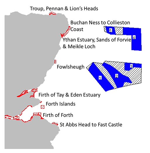
As with NE2-NE6, a key concern within POs E1 and E2 relates to the potential impact of collision on kittiwake. Consequently, the projects highlighted in relation to reducing uncertainty surrounding collision risk for kittiwake [OUTCOME], and to reduce the uncertainty surrounding distribution and connectivity [OUTCOME], in relation to NE2 and NE3 are also relevant here. This should include GPS tracking studies of populations within the Buchan Ness to Collieston Coast SPA, the Fowlsheugh SPA, the Forth Islands SPA, and the St. Abbs Head to Fast Castle SPA [ACTION]. To ensure optimal layout of turbines, modelled distributions, ideally combining both survey and GPS data [ACTION], should be produced, this would also help to reduce uncertainty in relation to apportioning [OUTPUT]. Further analyses of the GPS data should be used to determine the extent to which each PO is used for foraging and commuting, and to reduce uncertainty surrounding key parameters for collision risk models including flight heights and speeds [OUTPUT].
In addition to kittiwake, the SMP HRA also raises concerns about the potential for significant cumulative impacts on razorbills, which are also features of the SPAs listed above. As with kittiwake in relation to NE2 and NE3, reducing uncertainty surrounding the potential for significant cumulative impacts arising as a result of displacement for both species will require better quantification of the proportion of birds likely to be displaced by offshore wind farms [OUTPUT], which could be achieved through the analysis of post-construction monitoring data from existing wind farms [ACTION], and better quantifying the energetic and demographic consequences of displacement [OUTPUT].
As with NE2-NE6, having updated the input parameters and models used to assess the impacts of collision and displacement on kittiwake and razorbills within offshore wind farms on the east coast of Scotland, uncertainty surrounding cumulative impacts could be reduced further by ensuring analyses were re-run using a consistent approach based on the latest available evidence, using the CEF [ACTION].
As with NE2-NE6, uncertainty surrounding the population level consequences of any impacts on kittiwake populations could be reduced further using a meta-population model for the Orkney and east coast population [OUTPUT].
A1.10.2 Collect data in relation to seabird densities and behaviours in the offshore region during the non-breeding season
The SMP HRA highlights uncertainty surrounding the distribution of birds within both E1 and E2, particularly outside the breeding season. Given uncertainty in the distribution of birds outside the breeding season more generally (Waggitt et al., 2019), regional-level surveys of the Scottish east coast [ACTION] are required to better understand the relative importance of E1 and E2, particularly in relation to wintering birds. As a minimum, these surveys should include both POs and a 12km buffer around each. Surveys should cover a minimum of 5% of the total area and be carried out on a monthly basis for two years to begin in either March or September to coincide with the start of the start of the breeding or non-breeding season.
Having determined the distribution of birds outside the breeding season, and relative importance of E1 and E2, there is a need to develop methodologies to apportion impacts back to breeding populations [OUTPUT]. Initially, this will involve analysing geolocation data collected from birds at breeding colonies on the east coast of the UK [ACTION] to infer the likely breeding origins of birds present in E1 and E2. However, given the broad spatial resolution of these data, reducing uncertainty in apportioning further will require development of analytical methodologies [OUTPUT] or the development of longer-term attachment methodologies for GPS tags [ACTION].
In addition to understanding the distribution of birds within E1 and E2 outside the breeding season, there is also a need to understand the behaviour of these birds. However, approaches such as HMMs, which are used to classify seabird behaviour, rely on the availability of high-resolution tracking data. In the absence of a methodology for long-term tag deployment, alternative approaches are needed to quantify aspects of birds' behaviour. This should include deploying TDRs alongside geolocators for auks from east coast SPAs [ACTION] to estimate species time-activity budgets and the potential consequences of displacement. Similarly, flight height information can be collected as part of surveys using approaches such as LiDAR or digital aerial survey (Largey et al., 2021) in order to better understand species collision risk. However, given the availability of different approaches for estimating species flight heights, a trial of multiple sensors would be valuable [ACTION]. This would help to demonstrate how comparable estimates from different platforms are, and identify how any biases, or errors in these estimates may affect outputs from collision risk models.
A1.11 E3
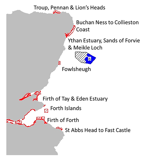
Water depth across PO E3 (Figure 19) is variable with areas of shallower (0-60m) and deeper (>60m) water. Whilst seabird usage of the deeper water areas may be low, the presence of shallower areas, the proximity of SPAs for which seabirds are designated features, and the proximity to several existing and planned projects means that SMP SEA considered that the impacts of E3 were likely to be minor negative – moderate negative. As a result, E3 was identified as being subject to higher levels of ornithological constraint, meaning that development within this PO cannot take place until such time that enough evidence on the environmental capacity for seabirds exists to reduce the risk to an acceptable level. This assessment is based on currently predicted levels of impact but, if evidence is presented that would enable these impacts to be revised downwards, it may be possible for development to proceed.
The key to unlocking offshore wind potential within PO E3 will be reducing uncertainty in existing assessments with a view to obtaining evidence that would enable currently predicted levels of impact to be revised downwards. Workshop participants highlighted three key routes to achieving this:
1. Reduce uncertainty surrounding the distribution of birds in E3 [OUTCOME]
2. Reduce uncertainty surrounding the magnitude of the predicted cumulative impacts of collision and displacement within offshore wind farms in Firth of Forth and Moray Firth [OUTCOME]
3. Reduce uncertainty surrounding the predicted population level effects of offshore wind farms in the Firth of Forth and Moray Firth [OUTCOME]
A1.11.1 Reduce uncertainty surrounding the distribution of birds in E3
As with NE2-NE6, there is the potential for developments within PO E3 to have significant in-combination effects on breeding kittiwakes within the Fowlsheugh SPA, Buchan Ness to Collieston Coast SPA and the Troup, Pennan and Lion's Heads SPA as a result of existing and planned developments within the Moray Firth. However, given the more southerly location of this PO, there is also the potential for significant in-combination effects on kittiwakes and other breeding seabirds within the Firth of Forth Islands SPA and the St Abbs Head to Fast Castle SPA as a result of existing and planned developments within the Firth of Forth and Tay region. Consequently, there is a need to better understand the distribution and origin of birds within this PO.
Given the magnitude of impacts predicted as a consequence of in-combination effects on the east coast of Scotland, it is important that any available capacity is developed in an optimal way. This can be informed through GPS tracking studies of birds from key SPAs including kittiwakes, razorbills, common guillemots, and herring gulls Larus argentatus from Buchan Ness to Collieston Coast SPA, Fowlsheugh SPA and Forth Islands SPA, with studies at Fowlsheugh SPA prioritised given the proximity to E3. Given the projected cumulative impacts on kittiwake populations, GPS tracking of birds from St Abbs Head to Fast Castle SPA and Troup, Pennan and Lion's Heads SPA should also be considered. Similarly, given past studies suggesting that gannets from the Forth Islands SPA may forage within PO E3 (Wakefield et al., 2013), GPS tracking of this population should also be considered [ACTION]. Given the potential for foraging distributions to vary between years, such data should be collected over multiple years (Robertson et al., 2014).
To aid apportioning, and better understand the at sea distribution of birds from SPA populations, it would be valuable to develop methodologies to combine data from GPS tracking and surveys [ACTION]. This would help in validating models derived from both GPS data and at sea survey data and would potentially allow the distribution of non-breeding birds in the breeding season to be quantified [OUTPUT] – a key missing component of current assessment methodologies. Combining data from GPS tracking and survey data is challenging, because of the mismatches in scale and focus between the data types but could be addressed using modern analytical methods such as data integration. Such analyses should seek to investigate the influence of oceanographic variables on species distributions [OUTPUT].
A1.11.2 Reduce uncertainty surrounding the magnitude of the predicted cumulative impacts of collision and displacement within offshore wind farms in Firth of Forth and Moray Firth
As with NE2-NE6, the key to reducing uncertainty surrounding the predicted cumulative impacts of collision and displacement within existing projects will be the collection of better data to feed into models, and improvements to the models themselves. In relation to collision, this is likely to focus on analyses of GPS tracking data [ACTION] to improve estimates of flight heights and speeds for species such as kittiwake, gannet and herring gull which are vulnerable to collision [OUTPUT]. As highlighted previously, flight height estimates are available from a variety of platforms and inconsistencies between these can contribute to uncertainty in the applicability of individual datasets. Consequently, a multi-sensor trial of methods to estimate seabird flight heights [ACTION] would be valuable. As with NE2-NE6, work to improve collision risk models by validating and/or improving the estimation of PColl and Flux would also help reduce uncertainty.
In relation to displacement, analysis of data collected from existing offshore wind farms [ACTION] will help to better quantify the proportion of birds likely to be displaced. As with NE2-NE6, these analyses should also consider whether there is any evidence that increased turbine spacing may influence displacement rates [OUTPUT], and therefore may be an effective mitigation measure. Having improved estimates of the proportion of birds likely to be displaced by offshore wind farms, there is a need to reduce the uncertainty surrounding the consequences of that displacement through the identification of core foraging areas using GPS and analyses of how the energetic costs of foraging influences survival and productivity [OUTPUT].
As previously, having updated the models and parameters input parameters used to assess collision and displacement, revising the estimated cumulative impacts associated with offshore wind farms in the Firth of Forth and the Moray Firth using the CEF [ACTION] will help reduce uncertainty surrounding predicted impacts and may help unlock offshore wind potential within E3.
A1.11.3 Reduce uncertainty surrounding the predicted population level effects of offshore wind farms in the Firth of Forth and Moray Firth
The key concern in relation to PO E3 relates to the potential for a significant in-combination effect on kittiwake populations within east coast SPAs as a result of existing and planned developments in the Firth of Forth and Moray Firth. Reducing the uncertainty surrounding the predicted population level effects associated with these developments may help to reduce the ornithological constraints associated with PO E3. As highlighted in relation to NE2-NE6, achieving this will require support for the collection of demographic data within SPAs on the east coast of Scotland [ACTION], and the development of a meta-population model that better accounts for the demographic processes, such as immigration and emigration, and existing pressures, such as fisheries and climate change, acting on kittiwake populations on the east coast of Scotland [OUTPUT]
Contact
Email: ScotMER@gov.scot