Sectoral Marine Plan: roadmap of actions
Road map of actions required to improve our understanding of the potential implications of ScotWind sites on seabirds as identified by the Sectoral Marine Plan.
5. Prioritisations of projects for Sectoral Marine Plan Roadmap of Actions
In total, 54 projects were identified which could reduce uncertainty and help determine whether POs subject to high levels of ornithological constraint could be unlocked (Appendix 2). The key focus of this project was to identify projects which could contribute to reducing the uncertainty associated with the projects progressing from the ScotWind leasing round and determine whether POs subject to a high level of ornithological constraint can be unlocked. Consequently, whilst projects which can reduce wider uncertainties are valuable, the focus for this prioritisation is on projects which can be carried out over the next 2-3 years, reflecting the likely timescales of the consenting process for ScotWind. Given the likely costs and timescales involved in this work, it is important to ensure that the existing work, highlighted above, is not duplicated. Discussions in the workshops highlighted a particular need to focus on reducing the uncertainty surrounding predicted impacts, particularly in relation to black-legged kittiwake, northern gannet, great black-backed gull, guillemot, and razorbill.
5.1 Reduce uncertainty around collision
Discussions about reducing uncertainty surrounding the estimated collision rates focussed on two key areas, collecting data on collision rates at operational wind farms, and refining the models, and their input parameters, used to estimate collision risk.
It was noted that there are collision monitoring systems installed at EOWDC, with an additional project planned for the Firth of Forth. There was interest in seeing a similar project in the Moray Firth. However, it was suggested that to add value beyond the studies already in progress, any additional projects would need to include a trial of mitigation measures, such as raising turbine hub height (e.g. Johnston et al., 2014) or painting a turbine blade black (e.g. May et al., 2020). The practicalities of such a study were discussed. It was felt that challenges involved in such a project, including reaching an agreement with a developer to host such a study, retrofitting equipment to turbines and, the overall cost, meant that it was unlikely that such a study would be of value in relation to reducing uncertainty for the projects progressing under ScotWind. Instead, it was suggested that this was an option that could be recommended as part of Post-Construction Monitoring within projects consented as part of ScotWind.
Given the importance placed in reducing the uncertainty associated with collision risk, and the fact that the study highlighted above was seen as a long-term aspiration, rather than something that would produce results that could feed into the ScotWind consenting or further planning processes, it was felt alternative projects were required. Two key areas were identified.
1. Reducing uncertainty surrounding species flight heights
2. Improving the realism of Collision Risk Models
It was noted that there are currently several projects underway with the aim of collecting additional flight height data. These include a Marine Scotland funded project using LiDAR[13], and work being undertaken using GPS tagging and altimeters in the Firth of Forth as part of post consent monitoring. At present, LiDAR is seen as being the most precise method for measuring species flight heights, although it is acknowledged that LiDAR does not detect heights for birds flying close to the sea surface (~2.5m, Cook et al., 2018). As such, the collection of additional flight height data using LiDAR was highlighted as a priority to reduce uncertainty surrounding collision risk estimates as part of ScotWind. Such a project should be at a sufficient scale to enable the generic flight height distributions from Johnston et al. (2014) to be updated. However, it was also recognised that LiDAR may be prohibitively expensive, meaning that, at a project level, alternative methodologies may be required. Flight height estimates may be affected by environmental variation as well as sources of error and bias associated with the data collection methodology. This makes comparing flight heights collected using different approaches challenging. Consequently, a study comparing flight heights from different methodologies, with data collected in similar locations, over a similar period, was highlighted as a priority in relation to reducing the uncertainty surrounding estimated flight heights to feed into collision risk models in relation to ScotWind applications.
At present, collision risk assessments are based on either the Band Collision Risk Model or, the stochastic Collision Risk Model (sCRM). However, a lack of validation means that there is uncertainty surrounding predicted collision rates. The models are based on a simple set of assumptions relating to how birds move through a wind farm and have two key components – an estimate of the total number of birds passing through a turbine rotor swept area, and an estimate of the probability of a bird passing through a rotor swept area colliding with a blade. Interest was expressed in moving towards an individual based model type approach for assessing collision risk. However, given data availability, this was felt to be a longer-term aspiration, as opposed to something that was feasible in relation to ScotWind applications. Instead, it was felt that moving towards a more modularised approach to assessing collision risk would be valuable, this will be facilitated through changes being made to the sCRM at present. Such a project would include considering how different types of data could be incorporated at each stage to ensure collision risk assessments were based on the best available data. These data include GPS estimates of flight speed and height (Cleasby et al., 2015; Masden et al., 2021; Ross-Smith et al., 2016) and estimates of avoidance behaviour obtained from collision monitoring systems (Skov et al., 2018), or GPS ( Johnston et al., 2021). As part of this, it would be important to carefully consider how avoidance rates were incorporated and used following any revisions to the model. This project was felt to be a priority in relation to reducing uncertainty surrounding collision risk estimates as part of ScotWind.
5.2 Reduce uncertainty around displacement
The proportion of birds displaced is a key source of uncertainty associated with the assessment of displacement. As projects have developed, we have gained a greater understanding of the proportions of birds from different species likely to be displaced. As these data were collected in the Southern North Sea, there is some uncertainty surrounding their applicability to offshore wind farms in Scottish waters. However, as projects develop, this uncertainty is likely to be reduced through the collection of post-construction monitoring data at operational wind farms in Scottish waters. It is important that there is strategic oversight of this monitoring to ensure that it is carried out in a consistent fashion. Whilst there was some discussion over the potential to investigate the role of turbine spacing on displacement, it was felt that this was a longer-term aspiration, rather than a project that could contribute to reducing uncertainty in relation to ScotWind applications.
At present, SeaBORD is a key tool for estimating the demographic consequences of displacement and assessing the resultant population level consequences. At present, its use is restricted to the chick-rearing period, though it would be relatively straightforward to extend it to also cover incubation and post-fledging. However, the greatest reduction in uncertainty would be achieved if the approach could be extended to cover the non-breeding season(s). Obtaining the energetic data necessary for Individual Based Model (IBM) approaches such as SeabORD can be challenging outside the breeding season and away from well-studied colonies. However, the deployment of Time-Depth-Recorders (TDR) and wet-dry sensors offers the potential to collect the necessary data, alongside the location information from geolocators. It was felt that updating SeabORD to cover the incubation and fledging periods initially and developing a similar approach for the non-breeding period(s) was a high priority which could make an important contribution to reducing uncertainty surrounding the potential impacts of displacement as part of ScotWind.
5.3 Surveys
Surveys are required to reduce uncertainty surrounding the abundance and distribution of birds within each of the POs. POs E1 and E2 are further offshore than the other sites, with greater uncertainty surrounding the distribution and abundance of birds within them (Waggitt et al. 2019). Consequently, a regional survey covering the Scottish East Coast, encompassing POs E1 and E2 with a 12km buffer around each, as a minimum, was highlighted as a key priority in relation to reducing uncertainty for the ScotWind applications. Following the guidance presented in Donovan & Caneco (2020), these surveys should deliver at least 5% coverage of the area, with transects no more than 5km apart. Surveys should be carried out on a monthly basis for a minimum of two years (24 months) and start either at the beginning of the breeding season (March) or the beginning of the non-breeding season (September). It is important that all survey data collected should be modelled with an appropriate set of environmental and oceanographic covariates (e.g. Waggitt et al., 2019), with a view to improving understanding of the drivers of seabird distribution at sea. If possible, consideration should be given to combining these data with data obtained from GPS tracking to establish links to breeding colonies and give a clearer indication of how birds are using the areas concerned.
There was some discussion surrounding work that could be carried out in relation to existing survey data. Whilst topics such as understanding the ability of digital aerial surveys to distinguish between small petrel species were not thought to be a priority, a better understanding of the proportions of juvenile/immature birds detected was thought to be of importance. This would enable two key advances. Firstly, it would enable a better understanding of the distribution of juvenile/immature birds at sea, making it more straightforward to apportion impacts on adults back to the relevant breeding colony. Secondly, it would make it possible to incorporate impacts to juvenile/immature birds into PVAs, reducing uncertainty surrounding predicted population level impacts. There was discussion as to whether such analyses should be restricted to recent digital aerial survey data or include information from other sources such as ESAS. It was felt that for QA purposes, and to ensure analyses reflected the situation at present, this work should be restricted to data collected using recent digital aerial survey data, including the data collected as part of the regional survey of the Scottish East Coast and the surveys of the POs described above. Analysis of the distribution of juvenile/immature birds from digital aerial survey data was highlighted as a priority in relation to reducing uncertainty for ScotWind applications.
5.4 Tracking – breeding season
Initial discussions focussed on the species and colonies that should be prioritised for GPS tracking during the breeding season. It was acknowledged that there are several tracking projects underway at present (Table 2). However, the majority of these are in the Firth of Forth and Tay region, and do not include birds from populations most likely to be impacted by developments in the POs. Where studies have been carried out, these began in the 2021 breeding season. As there can be substantial variation in habitat use between breeding seasons (Robertson et al., 2014; Thaxter et al., 2015), it is important that these studies are continued over multiple years to properly establish connectivity with POs. It was agreed that further tracking of black-legged kittiwake was a high priority, and that tracking of northern gannet, great black-backed gulls, and auk species (including Atlantic puffin) were similarly important. However, issues relating to the potential for tag effects and colony accessibility were highlighted for some species. Of the remaining species, it was felt that the proximity of Plan Option E3 to key colonies meant that there may be value in relation to tracking of Herring Gulls. Whilst uncertainties over predicted impacts were acknowledged, it was felt that GPS tracking of other species (including Sandwich tern, European storm-petrel, Manx shearwater, great skua and Arctic skua) were not a priority in relation to reducing uncertainty as part of the ScotWind leasing round.
Consequently, the prioritisations of species for GPS tracking was as follows:
1. Black-legged kittiwake
2. Northern gannet, great black-backed gull, auks (guillemot, razorbill, puffin)
3. Herring gull
4. Sandwich tern, European storm-petrel, Manx shearwater, great skua, Arctic skua
In addition to establishing connectivity between SPA populations and POs, the GPS data can be used to investigate patterns in seabird flight height, speed and avoidance of existing offshore wind farms (Cleasby et al., 2015; Johnston et al., 2021; Masden et al., 2021; Ross-Smith et al., 2016). By collecting more GPS data from these species within SPAs where there is likely to be connectivity with ScotWind POs, we will have greater power to investigate spatial and temporal patterns in these parameters, and better understand how they may be influenced by weather conditions. This will allow us to better quantify these parameters and consequently, reduce uncertainty surrounding estimates of collision risk.
5.4.1 Black-legged kittiwake
It was noted that tracking programmes are currently underway at Fowlsheugh, The Isle of May and St Abbs Head as part of post-consent monitoring programmes for offshore wind farms in the Firth of Forth. Given the between year variation in habitat use (Robertson et al., 2014) and the proximity of these colonies to ScotWind POs, it is important to ensure that this work continues, and is expanded to other colonies close to POs so that any connectivity can be properly assessed. This will also necessitate close co-ordination between the organisations concerned, to ensure any data collected are complementary. It was felt that tracking work would be valuable to reduce uncertainty in relation to connectivity between SPA populations and the ScotWind POs. Reflecting the locations of the POs, the key SPA populations highlighted as needing further tracking work were Buchan Ness to Collieston Coast, Troup, Pennan and Lions Heads, East Caithness Cliffs and Copinsay. However, it was recognised that there may be challenges in accessing birds within some colonies. Consequently, a two-stage process was suggested with a feasibility study to identify suitable sites for tracking in the first year, followed by tracking in the second. It was also felt that there may be value in tagging birds in and around the Moray Firth and Aberdeenshire Coast, but outside SPAs, with a view to improving apportioning.
5.4.2 Northern Gannet
The need for additional GPS tagging of northern gannets was discussed to reduce uncertainty surrounding connectivity between SPA populations and ScotWind POs, and to improve apportioning. It was noted that tagging work would continue at the Bass Rock as part of post-consent monitoring for offshore wind farms located in the Forth and Tay region. It was felt that additional GPS tagging of SPA populations on Fair Isle, Sule Skerry and Noss may be valuable. In addition, whilst not a designated feature of Troup, Pennan and Lion's Heads SPA, it was also felt that deploying GPS tags at this site would be valuable in relation to improving apportioning. However, it was noted that there may be accessibility issues at these sites. Consequently, it was recommended that a feasibility study was carried out in summer 2022 to identify suitable locations to deploy GPS tags within these colonies, with a view to deploying tags in summer 2023.
5.4.3 Great Black-backed Gull
Whilst great black-backed gulls have been observed in and around offshore wind farms and ScotWind POs within the Moray Firth, there is considerable uncertainty surrounding the origins of these birds. A variety of options were discussed including tagging birds within the East Caithness Cliffs and Copinsay SPAs and attempting to capture birds at sea. Of these, deploying GPS tags on birds within the Copinsay SPA was felt to be the most immediately feasible option, with GPS tagging of birds within East Caithness Cliffs SPA also of value. Such deployment would be dependent upon potential tag effect issues being resolved. In addition to facilitating an assessment for potential interactions with POs in the Moray Firth, such a study would provide valuable behavioural data for a species which is currently data limited, reducing uncertainty surrounding the assessment of collision. Ass an initial planning task, a feasibility study should be undertaken to identify accessible nests at which to capture birds. Consideration over whether to capture birds at sea should await the outcome of a review of potential methods and will require careful discussion with the Special Methods Technical Panel of the BTO ringing committee.
5.4.4 Common Guillemot and Razorbill
There was some discussion in relation to whether the purpose of tracking would be to assess connectivity or, to quantify potential displacement and/or barrier effects. It was felt that inferences about the potential for displacement and/or barrier effects could be drawn from data collected as part of post-construction monitoring on the Isle of May, and, as such, the focus should be on establishing connectivity. At present, common guillemot and razorbill are not believed to make substantial usage of the North-Eastern cluster of sites, though there is some uncertainty surrounding their potential usage of NE7 and NE8, which are further offshore than the other NE POs. GPS tracking of birds from the East Caithness Cliffs SPA could address this uncertainty, though there are questions over the accessibility of birds within this SPA. Consequently, a feasibility study of capturing birds within this site was suggested, alongside consideration of the feasibility of capturing birds at sea. Given their locations, the potential for connectivity between birds within the Fowlsheugh and Buchan Ness to Collieston Coast SPAs and POs E1-E3 was highlighted as being of importance. GPS tagging of common guillemot and razorbill within Fowlsheugh and Buchan Ness to Collieston Cliffs SPAs was highlighted as a priority to reduce uncertainty surrounding the potential impacts of POs E1-E3 on these species. These POs include six lease agreement offers, consequently these projects would benefit from a strategic approach to data collection.
5.4.5 Atlantic Puffin
A lack of published data on Atlantic puffin foraging ranges means that there is still considerable uncertainty surrounding the potential for species to interact with offshore wind farms. Whilst UKCEH have been carrying out trials of GPS tracking Atlantic puffins, potential tag effects mean that these data may not be suitable for use in assessments for offshore wind farms. Robust GPS data would enable a more accurate assessment of the species foraging range and reduce uncertainty surrounding apportioning. A trial using loggers of different sizes would help disentangle potential tag effects, enabling future deployment of GPS tags within SPAs where birds may interact with the ScotWind POs including Noss, Fair Isle, North Caithness Cliffs and Sule Skerry and Sule Stack. Consequently, a trial of different logger types to understand potential device effects on Atlantic puffins was highlighted as a priority for reducing uncertainty in relation to the ScotWind applications.
5.4.6 Herring Gull
Whilst it was noted that herring gulls are unlikely to be an issue for most of the POs, they have been observed offshore, and roosting on the turbines at Kincardine Offshore Wind Farm, close to PO E3. Given the large number of birds present in urban colonies on the East coast, there is considerable uncertainty surrounding the origin of birds in the offshore environment. Consequently, it was felt that GPS tracking of birds from the Fowlsheugh and Buchan Ness to Collieston Coast SPAs would be valuable to reduce uncertainty surrounding the potential for interactions with POs E1-E3.
5.4.7 Other Species
It was highlighted that there is considerable uncertainty over the potential for some other designated features of SPAs to interact with ScotWind POs. These include Manx shearwater, European Storm-petrel, Leach's petrel, great skua, Arctic skua and Sandwich tern. In some cases (e.g., Arctic skua) the size of the population concerned is small, meaning any impact could have a significant effect at a population level. However, given the location of the POs relative to SPAs for which these species are designated features, and what we know about their ecology, it was felt that these were unlikely to pose a constraint to the ScotWind leasing round, and are therefore not a priority for GPS tracking at this stage.
5.4.8 Further analysis of tracking data
Having collected tracking data, it is important to consider how these data can be used to reduce uncertainty in relation to ScotWind beyond simply quantifying connectivity between designated features of protected sites and the POs. Three key areas were identified:
1. Improve apportioning
2. Link offshore behaviour to demography
3. Better describe the flight characteristics of foraging and commuting behaviour
Key to this is understanding why birds are where they are, and what the consequences of this may be in relation to impacts from offshore wind farms. At present, apportioning is based on rough criteria such as foraging ranges and colony size. By using GPS tracking data to establish connectivity between sites, this can be improved. Further refinements can be made through behavioural classification to understand whether birds detected during surveys are likely to be using an area for foraging or commuting behaviour, and therefore better understand what the consequence of any loss of habitat might be.
To reduce the uncertainty surrounding the potential consequences of displacement and barrier effects, it is important to better understand the link between behaviour and demography. Whilst obtaining sufficient data to quantify the impact on adult survival is likely to be challenging, detecting impacts on breeding success and body mass (a potential surrogate for survival) may be more achievable. Examining this in more detail would enable us to better understand the relative importance of different marine areas to a colony, and the energetic and demographic consequences of losing an area.
Collision risk is likely to be driven by behaviour. At the highest level, this may be linked to differences in flight height and speed between foraging and commuting flight. However, it is also likely to be affected by environmental variation driven by factors such as wind speed and direction, or changes to behaviour inside an operational wind farm. GPS tracking data enable us to better investigate this variation and consider the likely consequences for collision risk.
In developing the tracking studies set out above, in addition to assessing connectivity between designated features of SPAs and ScotWind POs, researchers should consider the extent to which the resulting data could also be used to address one, or more, of the topics set out below.
Tracking – non-breeding season
Building on the discussions above, there was consensus that the greatest reduction in uncertainty relating to the non-breeding season would be a reduction in the uncertainty surrounding the consequences of displacement. Whilst there was agreement that a better understanding of the exposure of migrating northern gannets and skuas to offshore wind farms was important, it was felt that black-legged kittiwakes and auks (including puffins) were the priority for this work.
Efforts are underway to enable the collection of data that can be used to investigate finer scale distributions of birds outside the breeding season through the development of long-term attachment methods, the miniaturisation of GPS tags and assessing the feasibility of MOTUS type tracking. However, these efforts are unlikely to result in the development of an approach that can be deployed at the scale necessary within the timeframes allowed by the ScotWind process. Consequently, collection of these data is likely to rely on the widespread deployment of geolocators. Despite the low precision of spatial locations derived from these data, they are likely to be of value in relation to apportioning impacts outside the breeding season back to SPA populations. However, the precision of these data could be improved through the collection of temperature or stable isotope data alongside the geolocator data and through the adaptation of the analysis to incorporate these additional data sources.
Deploying geolocators would enable us to investigate whether birds are using marine areas where offshore wind development is taking place outside the breeding season. However, the use of activity loggers such as TDRs or wet/dry sensors would enable us to investigate activity budgets outside the breeding season. In combination, these data would enable us to investigate the potential consequences of loss of wintering habitat, particularly if tied to individual level data such as breeding success or changes in adult body mass over winter. This would make it possible to move towards an IBM-type approach to assessing the consequences of displacement outside the breeding season, as alluded to above.
It was acknowledged that, to be of most value, a project such as this would need to involve international collaboration (e.g., with SEATRACK) to capture data from birds outside Scottish waters. Such a project has the potential to substantially reduce uncertainty in relation to the consequences of displacement outside the breeding season within the timeframes allowed by ScotWind. To facilitate this work, it was recommended that geolocators should be deployed on kittiwakes, guillemots, razorbills, and puffins from a minimum of 10 Scottish colonies, and involve collaboration with researchers working in colonies outside Scottish waters, to enable more robust apportioning. Where size allows, activity loggers (e.g., TDRs or wet/dry sensors) should be deployed alongside the geolocators to enable activity budgets outside the breeding season to be inferred.
5.5 Demography
It was recognised that robust demographic data and models will be key to assessing future impacts and providing a baseline against which any compensatory measures can be assessed.
A key project discussed related to the development of a meta-population model for East Coast Kittiwake colonies. This has the potential to reduce uncertainty surrounding the predicted impacts of existing offshore wind farms and determine whether any of POs NE2, NE3, NE4, NE6 and E3 can be released from high levels of ornithological constraint. It is important that such a model should take account of biological processes, such as immigration/emigration and density dependence, and other pressures acting on the population such as fisheries and climate change. However, it was also acknowledged that, in the absence of more robust demographic data, the utility of such a model is likely to be limited, for example to identifying key gaps in our knowledge of the species demography. As such, whilst developing a model such as this is seen as important, it is also seen as a longer-term aspiration rather than an immediate priority for ScotWind projects. Aspects of this work may be addressed by a PhD project at the University of Aberdeen that started in autumn 2021.
A more pressing priority is the collection and collation of demographic monitoring data. Whilst kittiwakes are a priority for this, other species including great black-backed gull, gannet and auks are also important. Reflecting the locations of the POs subject to high levels of ornithological constraint, the focus for this work should be on North East and East Coast as well as the Orkney colonies. The resulting data could be used to feed into meta-population models, such as the one described above, but also to establish baselines against which population level impacts, and the effectiveness of any compensatory measures, if these are determined to be required, could be judged. Data collection on this scale will require substantial effort, and it is important that this effort is adequately resourced. Opportunities for novel approaches to data collection (e.g., the use of Motus-style tracking to investigate return rates and dispersal, cameras for remote monitoring of productivity) should be considered. However, this work is likely to be a long-term project. It can take a minimum of 5 years, and ideally 10, to generate the data necessary to estimate robust survival rates depending on the type of data being collected and levels of inter-annual variability. Consequently, despite the importance of this work, it is unlikely to result in data that can contribute to reducing uncertainty in relation to the ScotWind projects. However, both to assess any population level consequences of ScotWind, and to inform future planning and leasing rounds, it is of vital importance that a long-term funding strategy for collecting seabird demographic data is put in place.
5.6 Timelines and key considerations
The projects identified above include the collection of new data, analysis of existing data and continued development of existing tools. Strategic oversight of these projects is vital to ensure that they complement one another and maximise opportunities for reducing uncertainties surrounding impacts on key species. Details of these projects, including key deliverable, constraints and indicative budgets are given in Table 5.
Projects prioritised in order to reduce uncertainty surrounding predicted impacts of ScotWind projects
- Project: Regional Digital Aerial Survey covering E1 and E2
- How project will address ornithological constraints: Reduced uncertainty surrounding species abundance and distribution within POs E1 and E2 in the breeding and non-breeding seasons
- Data & expertise requirements:
- Familiarity with principles of survey design to ensure unbiased data collection.
- Familiarity with digital aerial survey protocols.
- Appropriate QA procedures for species ID from digital imagery.
- (Potential added value – ability to estimate species flight heights)
- Key constraints in delivery:
- Availability of survey plane & equipment.
- Weather conditions
- Deliverables: Monthly estimates of abundance and distributions of seabirds on the Scottish East Coast
- Timescales: Monthly surveys over 1 year starting September 2022/March 2023 (to coincide with start of breeding or non-breeding season) and to cover 2023 breeding season to allow comparison with GPS tagging data
- Mechanisms for delivery: Collaborative funding involving developers in Option Agreements 1, 2, 3, 4 & 5
- Budget: £500,000+
- Project: Regional LiDAR survey to collect flight height data
- How project will address ornithological constraints: Reduced uncertainty surrounding species flight heights to estimate the proportion of birds at collision risk height for the purposes of collision risk modelling
- Data & expertise requirements:
- Familiarity with principles of survey design to ensure unbiased data collection.
- Familiarity with digital aerial survey protocols.
- Familiarity with LiDAR data processing.
- Appropriate QA procedures for species ID from digital imagery
- Key constraints in delivery:
- Availability of survey plane and LiDAR equipment.
- Weather conditions
- Deliverables: Monthly measurements of flight heights for species vulnerable to collision risk (e.g., Kittiwake, Gannet & large gulls)
- Timescales: Monthly surveys over 1 year starting September 2022/March 2023 (to coincide with start of breeding or non-breeding season) and to cover 2023 breeding season to allow comparison with GPS tagging data
- Mechanisms for delivery: Strategic monitoring programme
- Budget: £500,000+
- Project: Analyse proportions of adult and immature birds from Digital Aerial Survey imagery
- How project will address ornithological constraints: Reduced uncertainty about population age-structure, understanding of the exposure of different age-classes to the effects associated with offshore wind farms
- Data & expertise requirements:
- Familiarity with data from digital aerial surveys.
- Familiarity with the processes and limitations involved in identifying and assigning age classes to birds from digital imagery.
- Consideration of potential biases in digital imagery.
- Understanding of the estimation of population age structures from demographic models & how to compare observed and expected age structures.
- Key constraints in delivery:
- Commercial confidentiality associated with digital aerial imagery.
- Availability of suitable data.
- Deliverables:
- Modelled distributions of adult and juvenile/immature age classes.
- Comparison of observed and expected population age structures.
- Timescales: Six months to coincide with the second year of data collection of regional digital aerial survey.
- Mechanisms for delivery: Scottish government, SNCB, or strategic funding.
- Budget: c. £50,000
- Project: Feasibility study for widespread tagging studies
- How project will address ornithological constraints: Determine the feasibility of GPS & GLS data collection at multiple sites in summer 2023, highlight most appropriate approaches (e.g., tags, sample sizes) to ensure tagging studies deliver data to reduce uncertainty about impacts of offshore wind farms on seabirds
- Data & expertise requirements:
- Experience of delivering seabird tagging projects on a wide range of species.
- Understanding of licensing conditions relating to device deployment on seabirds.
- Understanding of how to work safely, while causing minimum disturbance in seabird colonies.
- Key constraints in delivery:
- Accommodation during breeding season.
- Weather conditions.
- Transport to remote locations.
- Access to field sites
- Deliverables:
- Understanding of the key practicalities involved in a widespread tagging programme in summer 2023, including key limitations and constraints (e.g., availability of suitably trained personnel).
- Understanding the feasibility of deploying tags in new sites (Copinsay, Fair Isle, North and East Caithness Cliffs, Troup, Pennan and Lions Heads).
- Timescales: Summer 2023 breeding season (June/July) for site visits with final recommendations and plans submitted winter 2023/22
- Mechanisms for delivery: Developers with projects in areas of high ornithological constraint (NE2, NE3, NE4, NE6, E3)
- Budget: c. £50,000
- Project: Investigation into potential device effects on Puffins
- How project will address ornithological constraints: Determine the feasibility of deploying GPS tags on Puffins as a means to reducing uncertainty surrounding potential interactions with offshore wind farms.
- Data & expertise requirements:
- Experience of delivering seabird tagging projects, particularly in relation to burrow-nesting species.
- Understanding of licensing conditions relating to device deployment on seabirds.
- Understanding of how to work safely, while causing minimum disturbance in seabird colonies.
- Understanding of importance of monitoring & assessing potential tag effects
- Key constraints in delivery:
- Accommodation during breeding season
- Weather conditions
- Transport to remote locations
- Access to field sites
- Availability of easily accessible and observable puffin nests.
- Deliverables: Assessment of the potential for tag effects on puffins, recommendations about how these can be minimised and whether further GPS deployment can be justified on ethical grounds and in relation to the quality of the data collected.
- Timescales: To begin November 2022 to enable tag orders to be placed by January 2023 at the latest and ensure all licensing and site permissions can be completed in time to ensure tag deployment in 2023 breeding season. Data analysis to follow with initial outputs winter 2023.
- Mechanisms for delivery: Scottish government, SNCB, or strategic funding.
- Budget: c. £50,000
- Project: Multi-colony & species GPS deployment
- How project will address ornithological constraints:
- Reduced uncertainty surrounding connectivity of designated features of SPAs and ScotWind POs and Agreement Options.
- Reduced uncertainty surrounding species distribution in relation to SPAs and ScotWind POs and Agreement Options.
- Understanding of species behaviour (e.g., Foraging/commuting) in SPAs and ScotWind POs and Agreement Options.
- Reduced uncertainty surrounding species flight heights and speeds.
- Data & expertise requirements:
- Experience of delivering seabird tagging projects on a wide range of species
- Understanding of licensing conditions relating to device deployment on seabirds.
- Understanding of how to work safely, while causing minimum disturbance in seabird colonies.
- Experience with the analysis of distribution and behavioural data from GPS tags.
- GPS tags with high sampling rates and remote download capabilities. Potential to set geofences and provide instantaneous estimates of speed.
- Altimeters to estimate flight altitudes.
- Key constraints in delivery:
- Lead in time for tag delivery, licensing & site permissions (typically 6 months)
- Accommodation during breeding season
- Weather conditions
- Transport to remote locations
- Access to field sites
- Deliverables:
- Modelled distributions of species foraging and commuting behaviour.
- Estimate of the % time spent within each Agreement Option
- Understanding of differences in distribution between conditions when traditional surveys can and cannot be carried out
- Estimates of flight heights and speeds when birds are foraging and commuting.
- Timescales: To begin November 2022 to enable tag orders to be placed by January 2023 at the latest and ensure all licensing and site permissions can be completed in time to ensure tag deployment in 2023 breeding season. Data analysis to follow with initial outputs autumn 2024.
- Mechanisms for delivery: Funding from developers with projects in areas of high ornithological constraint (NE2, NE3, NE4, NE6, E3) with close collaboration between all organisations involved in tagging and strategic oversight from key stakeholders including Scottish Government, SNCBs and industry representatives.
- Budget: c. £150-250,000 per species and site depending on the number tags deployed and potential efficiencies through the collection and analysis of data from multiple species at the same colony
- Project: GLS & TDR Deployment
- How project will address ornithological constraints:
- Reduced uncertainty surrounding the distribution of seabirds outside the breeding season and potential connectivity with POs and Agreement Options.
- Understanding of activity budgets and energy expenditure outside the breeding season to allow better quantification of potential energetic costs associated with any loss of habitat.
- Data & expertise requirements:
- Experience of delivering seabird tagging projects on a wide range of species
- Understanding of licensing conditions relating to device deployment on seabirds.
- Understanding of how to work safely, while causing minimum disturbance in seabird colonies.
- Experience with the analysis of GLS and TDR data
- Key constraints in delivery:
- Accommodation during breeding season.
- Weather conditions.
- Transport to remote locations.
- Access to field sites
- Deliverables: N/A
- Timescales: To begin November 2022 to enable tag orders to be placed by January 2023 at the latest and ensure all licensing and site permissions can be completed in time to ensure tag deployment in 2023 breeding season. Tag retrieval in 2024 breeding season with analysis over the following year.
- Mechanisms for delivery: Strategic funding (e.g., ORJIP, OWEC)
- Budget: c. £100-200,000 per species and site depending on the number tags deployed and potential efficiencies through the collection and analysis of data from multiple species at the same colony
- Project: Extension of SeabORD to cover full breeding season
- How project will address ornithological constraints:
- Data & expertise requirements: Reduced uncertainty surrounding the population level consequences of displacement during the breeding season
- Key constraints in delivery:
- Familiarity with SeabORD tool.
- Understanding of individual/agent-based models.
- Understanding of energetic models.
- Experience in the analysis of GPS tracking data.
- Deliverables: Updated SeabORD model
- Timescales: c. 6 months
- Mechanisms for delivery: Scottish government, SNCB, or strategic funding.
- Budget: c. £50,000
- Project: Revision of cumulative impact assessment using CEF
- How project will address ornithological constraints: Reduced uncertainty in relation to the magnitude of cumulative impacts associated with offshore wind farms in the Moray Firth and Firth of Forth.
- Data & expertise requirements:
- Familiarity with data underpinning assessments of the environmental impact of offshore wind farm.
- Familiarity with EIA process and precautionary principle.
- Familiarity with the tools underpinning EIAs (e.g., Band CRM, SeabORD, NE PVA tool).
- Key constraints in delivery:
- Availability of CEF tool.
- Agreement about a standard set of parameters to incorporate into model.
- Deliverables: Revised assessment of population level consequences of collision and displacement in the Moray Firth and Firth of Forth based on a common set of parameters and best available data.
- Timescales: June – December 2022, or 6 months following final delivery of CEF tool
- Mechanisms for delivery: Scottish government, SNCB, or strategic funding.
- Budget: c. £50,000
- Project: Developing an IBM approach to assessing displacement outside breeding season
- How project will address ornithological constraints: Reduced uncertainty about the individual and population level consequences of displacement outside the breeding season.
- Data & expertise requirements:
- Familiarity with the analysis of GLS and TDR data.
- Familiarity with individual/agent-based modelling.
- Familiarity with energetic modelling.
- Understanding of the potential population-level consequences of displacement.
- Key constraints in delivery: Availability of GLS and TDR data from multiple species (Kittiwake, Guillemot, Razorbill)
- Deliverables: An individual based model with which to assess the consequences of displacement outside the breeding season.
- Timescales: c. 1 year following retrieval of GLS and TDRs
- Mechanisms for delivery: Strategic funding (e.g., ORJIP, OWEC)
- Budget: c. £100-250,000
- Project: Modularisation of CRM & determine how GPS data & data from collision monitoring studies should be incorporated into CRM
- How project will address ornithological constraints: Reduced uncertainty in relation to collision estimates following consideration of alternative approaches to estimating different elements of the CRM (e.g., Flux rate, Probability of Collision), and improved understanding of how different elements of collision risk models contribute to final estimates and how different data sources may contribute to these elements.
- Data & expertise requirements:
- Understanding of different collision risk models.
- Understanding of different data sources that may contribute to CRMs (e.g., GPS, Digital Aerial Survey, LiDAR
- Key constraints in delivery: Availability of suitable data to incorporate in model(s)
- Deliverables:
- Recommendations about what constitutes best available data for each element of CRM.
- Recommendations about how different types of data should be incorporated into CRM.
- Assessment of the validity of alternative approaches to estimating flux and probability of collision.
- Timescales: c. 6 months
- Mechanisms for delivery: Scottish Government or Strategic Funding
- Budget: c. £50,000
- Project: Comparison of flight height data collected using different methodologies
- How project will address ornithological constraints: Reduced uncertainty in relation to different estimates of species flight heights through a better understanding how comparable data from different sources may be.
- Data & expertise requirements:
- Familiarity with methodologies for flight height data collection.
- Understanding of potential sources of uncertainty in flight height data.
- Key constraints in delivery:
- Availability of flight height data from multiple sources (e.g., GPS, altimeter, LiDAR, Digital Aerial Survey).
- Deliverables:
- Standardised approach to estimating species flight height distributions.
- Quantification of uncertainty associated with flight height estimates from different methodologies.
- Revised flight height distributions for key species.
- Timescales: 6 months following completion of regional LiDAR survey
- Mechanisms for delivery: Scottish Government or strategic funding.
- Budget: c. £50,000
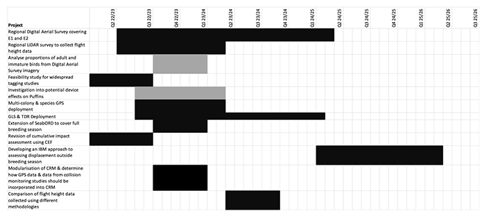
In the short term, there are several desk-based projects that could be undertaken over the next 6-12 months (Figure 8). These include extending SeaBORD to cover the breeding season as a whole, the modularisation of the sCRM along with the development of guidance setting out how data collected using GPS and collision monitoring studies should be incorporated into collision risk models and revising estimates of cumulative impacts using a standardised set of tools and data using the CEF. These projects are of relevance to all the sites under ornithological constraint. Also of value, though a lower priority, would be an analysis of the proportions of adult and immature birds recorded using digital aerial survey, and how this varies spatially and temporally.
Workshop participants highlighted the value of further collection of GPS data. In addition to quantifying connectivity between SPA populations and POs, these data could be used to reduce uncertainty surrounding apportioning and the parameters used in the assessment of collision risk and displacement. It was recognised that issues relating to capacity and logistics meant that such data collection was unlikely to be feasible in the 2022 breeding season. However, as tagging is likely to take place at new sites, there would be value in recce-ing those sites during the 2022 breeding season with a view to identifying sites for tagging work in the 2023 breeding season. The species and colonies for which further tracking work would be of value are highlighted in Table 6, along with the POs which are likely to be of relevance to the populations concerned. It may be possible to secure funding to support some of these projects from developers who have been secured agreement offers in the POs concerned. It is important that there is strategic oversight of all data collection, and that collaboration and data sharing agreements are in place to maximise the value of any data collected. Workshop participants also highlighted the potential value of a wider investigation of tag effects in puffins, but this was a lower priority.
Species and colonies which were highlighted as being of importance for collecting GPS tracking data during the breeding season to assess connectivity with ScotWind POs.
- Species: Gannet
- Colony: Fair Isle
- Relevant PO(s): NE2, NE3, NE4, NE6, NE7, NE8
- Recce in 2022 required?: Y
- Species: Great Black-backed Gulls
- Colony: East Caithness Cliffs
- Relevant PO(s): NE2, NE3, NE4, NE6, NE7, NE8
- Recce in 2022 required?: Y
- Species: Guillemot
- Colony: Buchan Ness to Collieston Coast
- Relevant PO(s): NE2, NE3, NE4, NE6, NE7, NE8, E1, E2, E3
- Recce in 2022 required?: N/A
- Species: Guillemot
- Colony: Fowlsheugh
- Relevant PO(s): E1, E2, E3
- Recce in 2022 required?: N/A
- Species: Herring Gull
- Colony: Buchan Ness to Collieston Coast
- Relevant PO(s): NE2, NE3, NE4, NE6, NE7, NE8, E1, E2, E3
- Recce in 2022 required?: N/A
- Species: Herring Gull
- Colony: Fowlsheugh
- Relevant PO(s): E1, E2, E3
- Recce in 2022 required?: N/A
- Species: Kittiwake
- Colony: Copinsay
- Relevant PO(s): NE2, NE3, NE7, NE8
- Recce in 2022 required?: Y
- Species: Kittiwake
- Colony: East Caithness Cliffs
- Relevant PO(s): NE2, NE3, NE4, NE6, NE7, NE8
- Recce in 2022 required?: Y
- Species: Kittiwake
- Colony: Troup, Pennan and Lion's Heads
- Relevant PO(s): NE2, NE3, NE4, NE6, NE7, NE8
- Recce in 2022 required?: Y
- Species: Kittiwake
- Colony: North Caithness Cliffs
- Relevant PO(s): NE2, NE3, NE4, NE6, NE7, NE8
- Recce in 2022 required?: Y
- Species: Kittiwake
- Colony: Buchan Ness to Collieston Coast
- Relevant PO(s): NE2, NE3, NE4, NE6, NE7, NE8, E1, E2, E3
- Recce in 2022 required?: N/A
- Species: Kittiwake
- Colony: Fowlsheugh
- Relevant PO(s): E1, E2, E3
- Recce in 2022 required?: N/A
- Species: Razorbill
- Colony: Buchan Ness to Collieston Coast
- Relevant PO(s): E1, E2, E3
- Recce in 2022 required?: N/A
- Species: Razorbill
- Colony: Fowlsheugh
- Relevant PO(s): E1, E2, E3
- Recce in 2022 required?: N/A
The consequences of displacement outside the breeding season were highlighted as a key uncertainty. The potential to combine geolocation data with data from time-depth recorders, or wet-dry sensors, was identified as a valuable methodology for collecting information on both the distribution and the activity levels of birds outside the breeding season. Such data would be of value in developing an Individual Based Model (IBM) approach to assessing the consequences of displacement outside the breeding season. The key species for this are those that are known to be present in the North Sea outside the breeding season and which post-construction monitoring suggest may be vulnerable to displacement – kittiwake, guillemot, razorbill, and puffin. As with the GPS data, it is unlikely to be feasible to deploy tags during the 2022 breeding season, but effort should be made to deploy tags in the 2023 breeding season. Tags should be deployed at multiple colonies, similar to the approach in Buckingham et al. (2021), and could coincide with the deployment of GPS tags. The resulting data should be used to develop an IBM-type approach to assessing displacement outside the breeding season, similar to SeaBORD. The scale of a project of this nature, means that strategic funding bodies such as ORJIP or OWEC may be potential sources of funding.
The need for additional survey data was also highlighted during the workshops. Substantial uncertainty remains over the distribution of birds further offshore around POs E1 and E2, particularly outside the breeding season (Waggitt et al., 2019). There is a need for a wider, regional survey or the Scottish East Coast, covering these two POs with a 12 km buffer around each as a minimum, to address this uncertainty. All data should be analysed using a consistent spatial modelling approach, incorporating an appropriate set of environmental covariates.
In addition to further survey data, there was considerable interest in developing an updated set of generic flight height distributions for use in collision risk modelling to replace those of Johnston et al. (2014). It was felt that these data would be best collected using a wide-scale LiDAR survey carried out over a year on a monthly basis. Again, it was felt that there was a need to ensure strategic oversight of this project. There is considerable uncertainty in collision mortality estimates as a result of differences in flight heights measured using different approaches (e.g., GPS, LiDAR, Digital Aerial Survey). To maximise the value of these surveys, it is important to ensure they coincide with other data collection. Data should be collected in areas that are likely to be used by birds in the GPS tracking studies given above (Table 5), and should begin no earlier than August 2022, to ensure that they cover the 2023 breeding season, when flight height data will be collected using GPS. Ideally, spatial coverage should also include areas covered by standard Digital Aerial Surveys. This would enable a comparison of flight height distributions obtained using LiDAR, GPS, and Digital Aerial Survey during the 2023 breeding season, meaning that it would be possible to identify differences between them, and consider reasons for these differences. This would help to substantially reduce uncertainty surrounding estimates of species flight heights, a key parameter for the assessment of collision risk, by enabling an assessment of the sources of error, bias and uncertainty associated with each methodology. The cost for a project of this nature is likely to be substantial, meaning it may require multiple developers working collaboratively or, a strategic funding mechanism such as ORJIP.
5.7 Longer-term research priorities
Whilst not of immediate relevance to the ScotWind projects , workshop participants highlighted several other projects they felt were of importance in relation to reducing the uncertainty associated with the predicted impacts of offshore wind farms on seabird populations. Key amongst these was developing a long-term strategy to support demographic monitoring of East Coast seabird populations, particularly kittiwake. At present, monitoring is insufficient to detect the population level changes that might be associated with offshore wind development (Cook et al., 2019). Understanding consequences at a population level will be key to reducing uncertainty in relation to future leasing rounds. In order to do so, it will be necessary to collect additional colony-based data on demographic rates which should be made freely available and utilised fully. For example, any breeding abundance and productivity data collected should follow standard protocols for data collection and be entered into the Seabird Monitoring Programme database (https://app.bto.org/seabirds/public/index.jsp). There may also be scope with the proposed update to the Seabird Monitoring Programme handbook to include emerging methods such time lapse cameras (e.g. Seabirdwatch, see Youngflesh et al. (2021), or drone technology (Rush et al., 2018). With respect to survival, in addition to standard metal ringing studies, a range of approaches to data collection should be considered. Options should include the use of Retrapping for Adult Survival (RAS) studies (Horswill et al., 2018), large scale approaches to colour-ringing (O'Hanlon et al., 2021) and more novel approaches such as the use of MOTUS tracking (Taylor et al., 2017a), the two latter of which will also have scope to look at dispersal rates. Over the longer term, these data could be used to support the development of a meta-population model for key populations, such as the East Coast kittiwake population.
Workshop participants also highlighted projects to reduce uncertainty surrounding collision and displacement which should be considered as part of future post-construction monitoring plans. The first of these was to carry out additional collision monitoring studies. For added value, these should be used to assess the efficacy of mitigation measures, such as painting blades black and increased hub heights. The second relates to a more detailed analysis of the impact of wind farm layout, including turbine spacing, on displacement rates.
Contact
Email: ScotMER@gov.scot