Sectoral Marine Plan: roadmap of actions
Road map of actions required to improve our understanding of the potential implications of ScotWind sites on seabirds as identified by the Sectoral Marine Plan.
3. Workshop Discussions
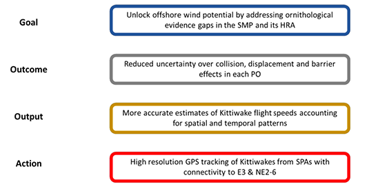
3.1 Theory of Change - Goal, Outcomes, Outputs and Actions
The application of the Theory of Change approach to identifying projects to address the key evidence gaps identified in the SMP is illustrated through an example below (Figure 1). Ahead of the workshop, the goal of "unlocking offshore wind potential by addressing the ornithological evidence gaps in the SMP and its HRA" was agreed with the Scottish Government. To deliver this goal, several outcomes are required to address these evidence gaps. For example, there is substantial uncertainty surrounding predictions of collision risk in relation to existing projects. Reducing this uncertainty is a key outcome required to deliver the overall goal. Models used to estimate collision risk are highly sensitive to input parameters, such as flight speed. Consequently, to contribute to the outcome of reducing uncertainty surrounding collision risk, an output of improved estimates of flight speed is required. Finally, to deliver this output, actions, such as the collection of high-resolution GPS data, are required.
The aim of the workshop was to identify the outcomes, and thus outputs and actions, required to deliver the goal of unlocking offshore wind potential by addressing ornithological evidence gaps identified in the SMP and its HRA (Figure 2).
The primary concern of identifying measures to generate the evidence required to assess the potential to unlock areas identified by the SMP as being of high ornithological importance formed the central theme of the workshop. Consequently, the first stage of the workshop was to identify the outcomes required to deliver this goal. Discussions focussed on the primary aim towards:
- Identifying the measures needed to unlock areas identified by the SMP as being under ornithological constraint (E1-3 & NE2, NE3, NE4 & NE6).
However, additional discussion was facilitated towards uncertainties involving species and populations previously thought to be exposed to potential impacts due to lack of connectivity with offshore wind development in Scottish waters, such as shearwaters, storm-petrels and skuas, but which may have greater connectivity to POs in the North and West of Scotland. Ultimately, discussions coalesced around four topics reflecting the outcomes required to unlock offshore wind potential, which are summarised in Figure 3.
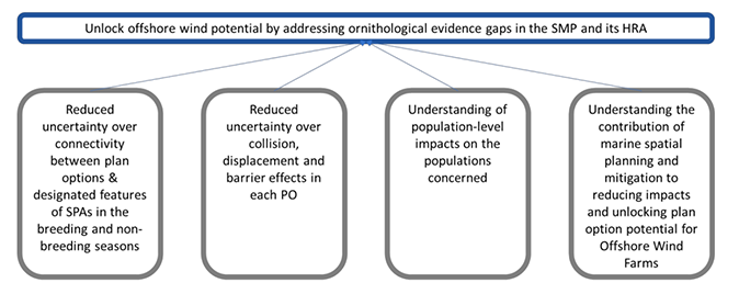
The relative importance of these outcomes varied by PO. For example, in relation to E1, E2 and N1-4, uncertainty over the potential for connectivity with Special Protection Area (SPA) populations was identified, and reducing that uncertainty was seen as key to unlocking offshore wind potential within those POs. Whilst reducing uncertainty over connectivity was also highlighted in relation to some of the other POs, it was felt that reducing uncertainty over predicted impacts from collision, barrier effects and displacement, and identifying options to reduce the predicted impacts of existing projects was of greater priority. More generally, participants also highlighted the importance of gaining a greater understanding of the potential population-level impacts on the populations concerned.
Having identified these high-level outcomes, the next step of the workshop was to identify the outputs required to deliver these. As part of this, workshop participants also identified the actions required to deliver these outputs (Figures 4-7).
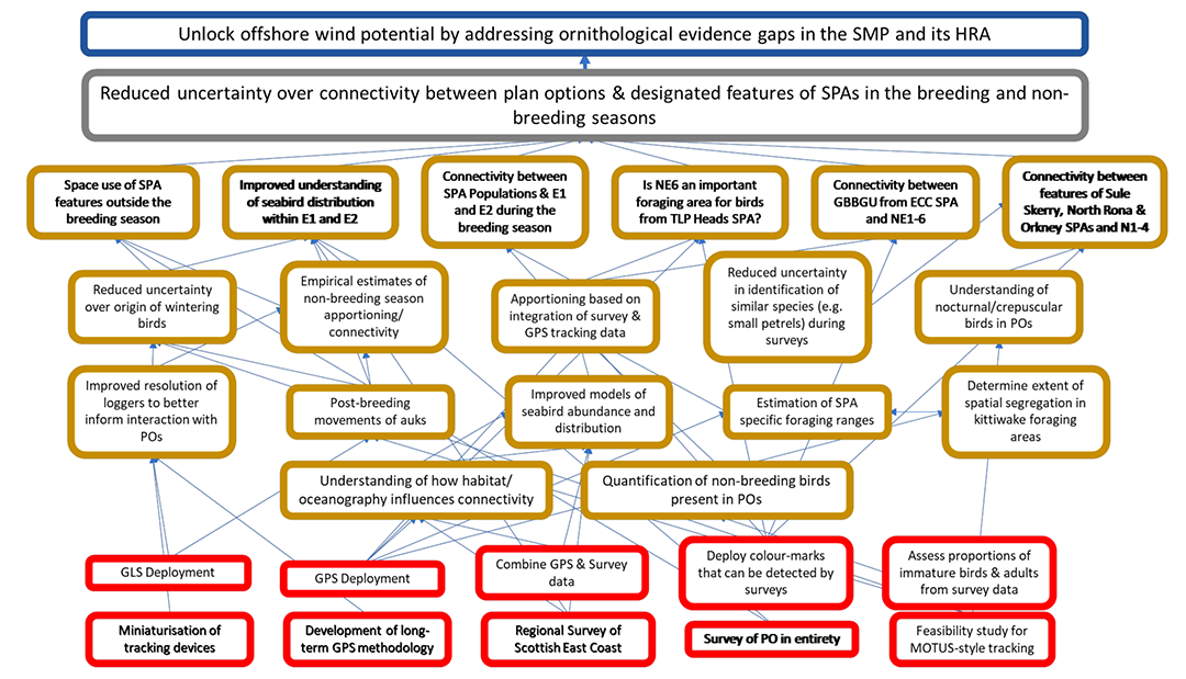
3.1 Outcome: Reduced uncertainty over connectivity between plan options and designated features of SPAs in the breeding and non-breeding seasons (Figure 4)
A key first step in unlocking wind energy potential is to get a better understanding of the distribution of birds within each PO and establish what connectivity exists with SPA populations [OUTPUT] to determine whether they may be at risk from the effects associated with offshore wind farms. This applies to both the breeding season and the non-breeding seasons.
Outside the breeding season, there remains uncertainty surrounding the origins of birds within each of the PO areas. As many species are at their breeding colonies for only a small proportion of the year, uncertainty in connectivity between POs and SPA populations makes assessing population-level impacts challenging. Initially, this is likely to require an improved understanding of the distributions of birds outside the breeding season, and the processes driving those distributions. Having a clearer understanding of the distribution of birds outside the breeding season will not remove the need to have aa better understanding of the locations in which they breed. At present, this is typically done with reference to Biologically Defined Minimum Population Scales (BDMPS) (Furness, 2015). However, workshop participants highlighted the value of moving towards approaches based on tracking data with which to assess connectivity and apportion birds from outside the breeding season back to their breeding colonies, with auks a particular priority. Whilst the miniaturisation of tracking devices [ACTION] may make the long-term deployment of GPS devices [ACTION] more practical for some species, it was recognised that in most cases, this was likely to involve the deployment of geolocators [ACTION] due to their smaller size, long battery life and ease of long-term attachment. However, the high degree of uncertainty in distributions derived from geolocator data was acknowledged, and participants highlighted the need to improve the spatial resolution of these data [OUTPUT]. Whilst these uncertainties were of relevance to all the POs, they were felt to be of greatest importance in relation to E1 and E2 where uncertainties in relation to the distribution of birds outside the breeding season were identified in the SMP.
Tracking of breeding adults from selected SPA colonies will provide only partial information on origins, as many seabirds are immature or originate from colonies where tag deployment is not practical. Therefore, capture of birds at sea in POs and tracking of those birds may be necessary if a better understanding of origins is sought, though there is a need to consider both the feasibility of this and the implications in relation to the licensing of tag deployment. This may necessitate the use of approaches such as Motus tracking (Taylor et al., 2017b) given the need for lightweight devices and the challenges of recapturing birds of unknown breeding origins, and development of the methodology for capture of birds at sea would be required [ACTION]. Alternatively, deploying colour marks that can be detected as part of survey efforts [ACTION] may be valuable.
Workshop participants also highlighted a need for improved understanding of distribution and connectivity to SPAs during the breeding season [OUTPUT], both generally, and in relation to specific SPAs. In contrast to the non-breeding seasons, it was felt that it was more straightforward to identify potential links between breeding adults from SPA populations and POs using GPS tracking studies [ACTION]. However, such studies should not rely on a single years' worth of data, as there may be considerable interannual variation in the at-sea distribution of breeding birds from an SPA (e.g. Thaxter et al., 2015). The relative importance of a PO to foraging birds should not simply be assumed to be the proportion of years in which it is used by foraging seabirds. For example, a PO may take on disproportionate importance relative to its use if it is only used in years when foraging conditions are poor (e.g. Bogdanova et al., 2014). To account for this, it will be important to model species distributions in relation to oceanographic variables and ecosystem processes [OUTPUT], some of which may vary on an annual basis (e.g. Robertson et al., 2014; Scott et al., 2010). Furthermore, it is much more difficult to assess what proportion of birds in POs are not adults from local SPAs, and that cannot easily be determined by tracking breeding birds from SPAs, highlighting the importance of new apportioning methods [OUTPUT] that integrate tracking and survey data [ACTION].
In the North East region, where POs are presently under a high level of ornithological constraint, uncertainties surrounding distribution within POs and connectivity with SPAs were also highlighted. There were specific questions relating to the use of PO NE6 by kittiwakes Rissa tridactyla from the Troup, Pennan and Lion's Heads SPA, and the origin of great black-backed gulls Larus marinus within POs NE2, NE3, NE4 and NE6. PO connectivity with SPAs at NE could be addressed by GPS tracking [ACTION]. Great black-backed gulls are a designated feature of East Caithness Cliffs SPA, and several other SPAs on the Orkney Islands. At present, there is very limited data on great black-backed gull foraging ranges (Thaxter et al., 2012; Woodward et al., 2019), partly due to potential tag effects, meaning there is uncertainty relating to the apportioning of the predicted impacts on great black-backed gulls to SPA populations. There is a need to consider the technical feasibility of tagging birds at new sites [ACTION], both in relation to the capture of individuals and the recovery of any data collected. The initial focus for this work should be the East Caithness Cliffs SPA, as the closest SPA population. However, depending on the outcome of that work, it may be necessary to expand the tracking to other SPA populations or, consider capturing birds at sea and deploying GPS-GSM tags, which download data over the mobile phone network, to link birds back to breeding populations.
There were also more general questions relating to the use of POs E1 and E2 by designated features of the Buchan Ness to Collieston Coast, Fowlsheugh, Ythan Estuary, Sands of Forvie and Meikle Loch, Firth of Tay and Eden Estuary, Firth of Forth Islands, Firth of Forth and St. Abbs Head to Fast Castle SPAs. As with the non-breeding season, workshop participants highlighted the need to develop improved models of seabird distribution [OUTPUT], combining survey and GPS tracking data [ACTION], where available (e.g. Matthiopoulos et al., 2022). These models should incorporate environmental covariates in order to facilitate an improved understanding of the drivers of seabird distribution at sea (e.g. Cleasby et al., 2020; Waggitt et al., 2019; Wakefield et al., 2017a), and how offshore wind farms may influence this.
Building on Woodward et al. (2019), the potential for estimating SPA-specific foraging ranges was highlighted alongside an interest in examining the extent of spatial segregation in breeding seabird foraging areas [OUTPUT], as suggested for gannets Morus bassanus and kittiwakes (Wakefield et al., 2013, 2017a). Addressing these issues will help to improve the apportioning of birds recorded within the POs back to their breeding colonies during the breeding season. To improve this further, it will be necessary to quantify the numbers and origins of non-breeding and immature birds [ACTION] present within each of the POs.
Regardless of season, efforts to improve methodologies for apportioning will require the accurate characterisation of baseline populations within each PO through the collection of survey data [ACTION]. This may be at the level of the individual PO, or, in the case of the east coast sites, a regional survey may be valuable.
Whilst not subject to a high level of ornithological constraint at present, notable uncertainty was highlighted in relation to the potential for breeding seabirds to interact with some of the more northerly POs [OUTPUT] (N1-4). These include species such as skuas, shearwaters and storm-petrels which have not, to date, been prominent in offshore wind farm EIAs. An added complication in the case of shearwaters and storm-petrels is the high level of nocturnal and crepuscular (twilight) activity they exhibit meaning that they may not be detected by existing survey methodologies. The miniaturisation of tracking devices, or, if feasible, the use of Motus-style tracking [ACTION], may help with this. However, the relative importance of such studies will be determined by the extent of development planned for these POs.
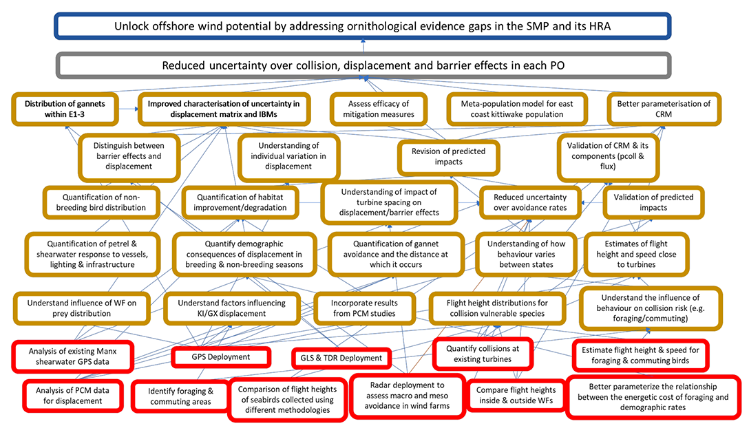
3.2 Outcome: Reduced uncertainty over collision, displacement, and barrier effects in each PO (Figure 5)
Quantifying the impacts of collision, displacement and barrier effects are a key part of impact assessments for offshore wind farms. However, uncertainty remains in relation to predicting the population-level consequences of impacts associated with a development. At present, the predicted impacts of consented and existing projects mean that there are ornithological constraints within POs NE2, NE3, NE4, NE6 and E3. In addition to this, uncertainties surrounding the distribution of key species within POs E1 and E2 (notably gannets, but also auks), and in relation to the impacts of displacement and collision on some of the species present in N1-4, pose challenges to assessing the impacts of developments within those POs. To understand whether offshore wind potential highlighted in the SMP can be unlocked, it will be important to reduce these uncertainties.
Reducing the uncertainty surrounding the impacts of collision, displacement, and barrier effects in relation to offshore wind farms within the POs requires assessing species connectivity with wind farms and, the risk posed to the species by each of these effects. Reducing uncertainty in relation to connectivity with offshore wind farms is addressed above. However, key uncertainties remain in relation to how the population-level consequences associated with different effects are assessed.
3.2.1 Displacement and barrier effects
At present, displacement is usually assessed using a matrix approach (e.g. Busch & Garthe, 2016) which combines the proportion of birds displaced with the proportion likely to experience mortality as a consequence of being displaced. As offshore wind farms have been constructed, understanding of the proportions of birds likely to be displaced or, to experience barrier effects has improved (Dierschke et al., 2016). Ensuring that information from post-construction monitoring studies, such as that reported in Dierschke et al., (2016), is incorporated into assessments [OUTPUT] will help to reduce uncertainty surrounding the predicted magnitude of displacement. However, these data are biased towards populations of species present in the southern part of the North Sea. Careful consideration is required to determine whether these findings may be transferable to Scottish waters. This could include analysis and peer-review of post-construction monitoring data from existing wind farms [ACTION], such as Beatrice, and others, such as Moray East and Neart na Gaoithe, which will be fully commissioned in the near future. In the past, post-consent monitoring data have been collected using inconsistent methodologies, and have been difficult to access (Marine Management Organisation, 2014). It is important to ensure that data from current and future post-consent monitoring studies are peer-reviewed, made publicly available and incorporated into tools such as Cumulative Effects Framework (CEF) being developed as part of a Scottish Government funded project[5].
Whilst, for many species, we may have some understanding of the proportion of birds likely to be displaced, there is still uncertainty about the demographic consequences of that displacement at both an individual and a population level. Displacement and barrier effects are likely to affect species through an increase in the energetic cost associated with foraging and flight. The matrix approach typically assumes that this will manifest as a reduction in adult survival, while more complex and biologically realistic approaches such as SeaBORD also incorporate impacts on productivity (K Searle et al., 2018). As a result, in order to reduce the uncertainty surrounding the individual and population level consequences of displacement and barrier effects, it is necessary to better parameterise the relationships between the energetic costs of foraging, the calorific content of food and demographic rates [ACTION] (Gremillet et al., 2003; Langton et al., 2014). Addressing these questions is likely to require focussed monitoring of behaviour and energy budgets as well as demographics of key vulnerable species such as auks [ACTION], particularly in colonies with connectivity to POs E3, NE2, NE3, NE4 and NE6, which are subject to the greatest ornithological constraint.
Workshop participants also highlighted the need to better understand the potential responses to offshore wind farms by species such as skuas, shearwaters and storm-petrels, which have not been a key feature of assessments to date, but which may be present in POs N1-4 and NE1 during the breeding season. The availability of GPS tracking data for Manx Shearwaters Puffinus puffinus from the Irish Sea region, where there are existing offshore wind farms (e.g. Dean et al., 2015) offers a valuable dataset with which to understand the potential response of this species to developments. Analyses of these data [ACTION] could reduce uncertainty surrounding the extent of displacement of this species by offshore wind farms, and in relation to parameters of relevance to collision risk, such as flight heights and speeds [OUTPUT]. However, the relative importance of such work will be determined by the extent of development planned for these POs.
There is also a need to understand the consequences of displacement outside the breeding season, when birds are no longer tied to their breeding colonies. This is likely to be challenging given the difficulties associated with long-term deployments of GPS devices on many of the species concerned. However, geolocation loggers typically record wet-dry and temperature data, and devices such as time-depth-recorders (TDRs) should be deployed alongside geolocation loggers [ACTION] (e.g. Duckworth et al., 2018; Dunn et al., 2020); the resulting data can be used to infer daily activity budgets, and together with colony monitoring could inform for the potential demographic consequences of displacement during the non-breeding season [OUTPUT] should core foraging areas be lost. This may have direct impacts on over-winter survival or, carry-over effects on productivity or survival in the subsequent breeding season (McKnight et al., 2020) The value of deploying geolocators to establish connectivity between SPAs and POs is highlighted above. However, if analytical methods could be developed to enable a more refined estimate of a birds' location, this could be used to give a clearer indication of the winter range of birds from a given colony, and hence their vulnerability to being displaced from a foraging area. If combined with an assessment of a birds' daily activity budget from wet/dry/temperature or TDR data, this could give a clearer indication of the demographic and energetic consequences of displacement during the non-breeding season. Any impact of displacement on survival during the nonbreeding season is likely to interact with impacts of food abundance and weather on overwinter survival (Fort et al., 2013; Reynolds et al., 2011). There may be no impact of displacement on birds with abundant food, whereas birds that are working to their limit in an environment where food is scarce may die if displaced, meaning a better understanding of relationships between food abundance and overwinter survival would be desirable, especially for auks. Whilst a key question in relation to POs E1 and E2 relates to the extent of connectivity with SPAs outside the breeding season, it is also important to understand the potential consequences of displacement from these areas. This will help to reduce uncertainty surrounding the demographic consequences of loss of foraging habitat, including potential carry-over effects, outside the breeding season [OUTPUT] and is also of importance to the POs subject to the greatest ornithological constraint (NE2, NE3, NE4, NE6 & E3).
3.2.2 Collision
Whilst post-construction data are available to reduce uncertainty in relation to displacement and barrier effects, estimates of collision risk are still largely reliant on modelled outputs. A lack of validation of these collision risk models (CRMs), and their individual components, means that there is still uncertainty surrounding the impact of collision on designated features of SPAs (Masden & Cook, 2016; Masden et al., 2021). Workshop participants identified three key areas where uncertainty surrounding collision risk could be reduced, potentially helping to unlock offshore wind potential within POs under greatest ornithological constraint: 1) Validation of the model and its components [OUTPUT]; 2) Improved quantification of key model parameters [OUTPUT]; 3) Revising collision estimates [OUTPUT] based on the best available data, and consistent models.
The most widely used model is the Band (2012) CRM, and there is a need to validate both the model itself, and its key components, the Probability of Collision (PColl) and the flux rate [OUTPUT]. Validation of the model and PColl is likely to require direct observation of seabird interactions, and quantifying collisions at existing turbines [ACTION], with turbine rotor-swept areas through projects such as the Offshore Renewables Joint Industry Programme Bird Collision Avoidance (ORJIP BCA) Project (Skov et al., 2018), and the ongoing project at the European Offshore Wind Deployment Centre (Tjomlov et al., 2021). As such, these may be longer-term aspirations. In addition to collecting data on collisions, a key aspect of these studies has been attempts to quantify avoidance behaviour. Further studies involving the use of GPS tags [ACTION] (e.g. Thaxter et al., 2018) and/or avian radar [ACTION] would be valuable in quantifying avoidance behaviour at a macro- and meso scale. However, as highlighted in Bowgen & Cook (2018), there is still uncertainty in relation to how these values relate to the avoidance rates used by CRMs, as they do not incorporate aspects of model error. Reducing uncertainty surrounding how to apply these avoidance rates [OUTPUT] will be a key part of reducing uncertainty surrounding predicted collision rates.
Estimated flux rates are likely to be a key component of model error (Masden et al., 2021). Using GPS tracking data, it may be possible to test the assumptions relating to bird movements that underpin estimates of the flux rate (e.g., birds move through the wind farm in a straight line at a constant height and speed), with a view to validating or generating more robust estimates of flux [OUTPUT] and reducing uncertainty surrounding collision rates within the POs under greatest ornithological constraint. However, in doing this, it will be important to consider the implications for the avoidance rates currently recommended for the Band (2012) Model. At present, in addition to avoidance behaviour, the avoidance rate captures aspects of model error, including in relation to the estimation of flux. Consequently, if we modify how flux is estimated this will have implications for how error is incorporated into the model (Cook, 2021), and avoidance rates would need to be revised to account for changes to the estimation of flux.
Estimated collision rates are also sensitive to estimates of species density, flight height and speed, though the range of values over which these parameters operate is not always clear (Masden et al., 2021). Methods to collect density data have developed in recent years, particularly in relation to the use of digital aerial surveys (Buckland et al., 2012). However, there has been less focus on ensuring robust data are available in relation to species flight heights and speeds. At present, recommended flight speeds are typically based on studies with limited sample sizes (Alerstam et al., 2007), resulting in uncertainty surrounding their wider applicability. Recent GPS tracking data differ from those recommended in current guidance, and show variation according to local conditions (Fijn & Gyimesi, 2018; Masden et al., 2021). Further analysis of flight speed data [OUTPUT] to reduce uncertainty surrounding predicted collision rates.
There has been an expansion in efforts to collect species flight height data in recent years (Largey et al., 2021). This has included the use of GPS tags (Ross-Smith et al., 2016), altimeters (Cleasby et al., 2015), radar (Fijn et al., 2015), LiDAR ( Cook et al., 2018), laser rangefinders (Harwood et al., 2018), boat (A. Johnston et al., 2014), and digital aerial survey (A. Johnston & Cook, 2016). However, there have been challenges in using these data to assess collision risk (Péron et al., 2020), particularly in relation to understanding how bias and error may drive differences in flight heights recorded using different technologies. Consequently, whilst the collection of site-specific flight height data from POs subject to the highest levels of ornithological constraint would be of value in relation to reducing uncertainty associated with collision risk, this value could be further enhanced through the collection of flight height data as part of a multi-sensor study [ACTION]. This would enable better quantification of the error and uncertainty associated with different methods for assessing seabird flight heights. In addition to this, there is the potential for birds to alter their flight heights within a wind farm, or close to turbines, as part of avoidance behaviour (Cook et al., 2014; Thaxter et al., 2018). Consequently, a comparison of seabird flight heights inside and outside wind farms [ACTION] would be valuable to explore the extent of this behaviour. Whilst ongoing work funded by the Scottish Government is investigating this using LiDAR, there would be value in extending this more widely using a greater variety of techniques, including GPS tracking data and data obtained using standard digital aerial surveys.
A better understanding of the influence of behaviour on collision risk [OUTPUT] is likely to help reduce uncertainty further. Both flight height and speed vary spatially (Cleasby et al., 2015; Fijn & Gyimesi, 2018; Masden et al., 2021), by sex (Lane et al., 2020), and are likely to be linked to behaviours such as foraging and commuting. Approaches such as Hidden Markov Models (HMMs) can be used to classify behaviours, and identify areas used for foraging and/or commuting flight (Thaxter et al., 2019). Identifying areas used for specific behaviours [ACTION] may enable us to reduce uncertainty in collision estimates further using behaviour specific estimates of flight height and speed [ACTION]. This would also help with spatial planning in each of the POs by identifying areas where collision risk is lowest. Generating the data necessary for these analyses, and to inform analyses of flight height and speed, will require the deployment of high-resolution GPS tags [ACTION] on vulnerable species within east coast SPAs, including gannets, kittiwakes, and great black-backed gulls. To ensure that the data reflect the breeding season as a whole, and potentially, parts of the non-breeding season, it will be important to develop approaches that allow for the long-term deployment of tags [ACTION] for the species concerned.
In addition to a greater range of data being available to feed into collision risk models, aspects of those models have also changed. The original Band et al. (2007) CRM has been updated to better reflect data collection in the offshore environment (Band, 2012), and take advantage of the continuous flight height distributions produced by Johnston et al., (2014). This has subsequently been refined further through the development of the stochastic collision risk model (sCRM) (Masden, 2015; McGregor et al., 2018) which incorporates variability in the model input parameters in order to characterise the uncertainty surrounding the estimated collision risk. Workshop participants highlighted the potential to reduce uncertainty within the POs subject to greatest ornithological constraint through refining existing collision risk estimates based on the latest available data [OUTPUT], and most up to date iteration of the collision risk model, which could potentially be facilitated using the CEF tool.
Finally, recent data has highlighted individual variation in the responses of both common guillemot Uria aalge and gannets to offshore wind farms (Peschko et al., 2021; Peschko, Mercker, et al., 2020). Workshop participants highlighted the need to better understand individual variation in relation to offshore wind farms [OUTPUT], and the implications for the assessment of displacement, barrier effects and collision risk at a population level.
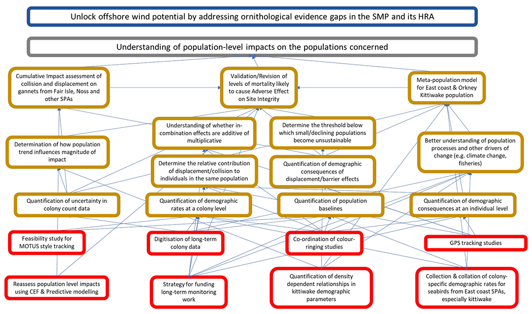
3.3 Outcome: Understanding of population level impacts on the populations concerned (Figure 6)
A crucial part of the assessment process is estimating the population level consequences of predicted impacts on designated features of protected sites. This relates to both the impact of an individual wind farm and the cumulative impact of multiple wind farms. The assessments are typically based on population models (Cook & Robinson, 2017) which can be highly sensitive to assumptions relating to demographic parameters and processes (Miller et al., 2019). However, data to parameterise these models are often limited (O'Hanlon et al., 2021; Horswill & Robinson, 2015) meaning that estimates must be inferred from elsewhere, potentially introducing considerable uncertainty into the process. Workshop participants highlighted the need to improve both models and the data underpinning them.
At present, monitoring at colonies where adverse effects on site integrity could not be ruled out is insufficient to detect impacts of the magnitude associated with offshore wind farms (Cook et al., 2019; Horswill et al., 2018). Consequently, there is uncertainty surrounding the data used to parameterise the population models, and the resulting predictions relating to population level consequences. Reducing the uncertainty surrounding the predicted population level consequences associated with offshore wind farms is likely to be a key part of unlocking offshore wind potential in POs. Improving data availability will be key to this. As a first step, there may be historic monitoring data which have yet to be digitised and made available through the Seabird Monitoring Programme. Workshop participants highlighted the value in ensuring that historic colony population size data are obtained and digitised [ACTION], as this would help to reduce uncertainty surrounding existing colony data, and baseline estimates of population size [OUTPUT].
The importance of supporting the expansion of demographic monitoring more widely was highlighted. Existing schemes, including the Seabird Monitoring Programme[6] and Retrapping Adults for Survival[7], are key to this. The impacts associated with offshore wind farms are likely to be detected in demographic rates before they become apparent in population counts. At present, much of this monitoring is carried out by volunteers, and the importance of ensuring a strategy is put in place to fund and support monitoring work [ACTION] was highlighted. Reflecting the importance of generating robust estimates of survival, workshop participants identified establishing and co-ordinating large scale colour ringing studies of vulnerable species such as kittiwakes as a priority [ACTION] (O'Hanlon et al., 2021). Establishing the feasibility of novel technologies to improve estimates of demographic parameters (e.g., MOTUS tracking for survival and remote camera monitoring for productivity) [ACTION] was also discussed.
Given evidence of individual-level differences in response to offshore wind farms (Peschko et al., 2021; Peschko, Mercker, et al., 2020), there is a need to better understand the demographic consequences of individual variation in response to offshore wind farms [OUTPUT]. This is likely to require GPS tracking studies [ACTION] to quantify the extent of individual variation in usage of offshore wind farms. Where possible, these should be combined with the demographic monitoring described above, and empirical studies that quantify effects on fitness-related traits (e.g., behaviour, energetics) and demographic rates at the individual level [OUTPUT]. This would offer a powerful approach for quantifying population-level consequences, and such opportunities should be fully considered and implemented where possible.
A key concern relating to the POs under the highest levels of ornithological constraint is the potential for significant, negative cumulative impacts. Given the levels of ornithological constraint associated with POs on the East coast, this highlights the need for validation and/or revision of the levels of mortality likely to result in an adverse effect on site integrity [OUTPUT]. This will require a better understanding of the processes influencing cumulative impacts. For example, it is unclear whether the impact of multiple wind farms are likely to be additive or multiplicative (Humphreys et al., 2016). Similarly, it is unclear how the impacts associated with multiple anthropogenic pressures should be incorporated into cumulative impact assessments, though the impact of one pressure may exacerbate the impact of another. For example, Frederiksen et al. (2004) highlighted how the impact of industrial fisheries could exacerbate the impact of climate change on kittiwake populations, and Searle et al. (in press.) highlighted the importance of accounting for climate change when quantifying the effects of offshore renewables.
Individual-based models provide one possible way of moving beyond simple additive assumptions in relation to cumulative impacts by simulating the energetic, behavioural and demographic consequences of interacting with multiple wind farms (K Searle et al., 2018), or of interacting with one wind farm in multiple ways (e.g. being susceptible to both displacement and collision effects) (Searle et al., in press). However, as a first step, workshop participants highlighted the need to ensure cumulative impact assessments within those POs were based on currently accepted methodologies, and the latest available data, using tools such as CEF [ACTION]. Given current constraints and uncertainties associated with offshore wind farms on the Scottish east coast, workshop participants highlighted the value of a robust cumulative impact assessment for gannet populations within Scottish SPAs [OUTPUT].
Kittiwakes pose a particular consenting risk to future Scottish Offshore Wind Farm development. Workshop participants suggested that the development of a meta-population model for the Orkney and east coast kittiwake population [OUTPUT] would be of value in relation to reducing uncertainty surrounding projected population level consequences associated with developments in POs NE2, NE3, NE4, NE6 and E3. To develop such a model, there is a need for a better understanding of the pressures acting on the kittiwake populations concerned, and how these drive processes such as density dependence, immigration, and emigration [OUTPUT]. Besides the expansion of offshore wind farms, seabirds are subject to multiple pressures (Burthe et al., 2014) including; climate change (Sydeman et al., 2021), fisheries (Sydeman et al., 2017), oil and gas extraction (Begg et al., 2013) and shipping (Schwemmer et al., 2011). A better understanding of how these processes are driving population trends and demographic rates will help to reduce uncertainty in models of population response to offshore wind farm impacts.
Whilst incorporating demographic processes into population models can increase biological realism, in many cases, they act as a buffer to the predicted negative effects associated with wind farms. At present, the evidence with which to properly parameterise these processes is very limited (Horswill & Robinson, 2015). As a result, given the need for assessments to be precautionary, models are typically fitted assuming closed populations and no density dependence (Cook & Robinson, 2017), resulting in increased uncertainty surrounding the predicted population level consequences associated with offshore wind farms. Consequently, to properly parameterise models with greater biological realism, there will be the need to ensure that the impacts of existing pressures arere properly accounted for in demographic rates and processes. This would necessitate the collection and collation of colony-specific kittiwake data from Orkney and east coast colonies [ACTION] to properly quantify baseline population estimates and demographic rates [OUTPUT], and an examination of these data to quantify any density dependent processes experienced by these kittiwake populations [ACTION].
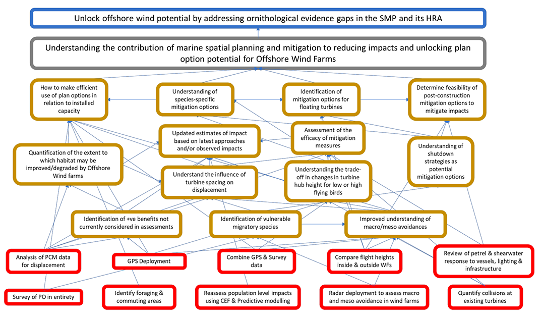
3.4 Understanding spatial marine planning and mitigation towards reducing impacts and unlocking plan option potential for OWF (Figure 7)
In relation to POs under a high level of ornithological constraint (E3, NE2, NE3, NE4, NE6), workshop participants considered the potential to reduce this constraint through the revision to predicted impacts based on updated evidence and analytical methodologies and determining the potential for mitigation options to reduce predicted impacts either pre- or post-construction.
Approaches to impact assessment have developed in recent years. In relation to displacement and barrier effects, in addition to the widely used matrix approach (e.g. Busch & Garthe, 2016), Individual Based Models (IBMs) such as SeaBORD are available (Searle et al., 2018). Similarly, the original Band CRM (Band et al., 2007), developed for use onshore, has been replaced by one which better reflects data collection in the offshore environment (Band, 2012), and has recently been updated to incorporate stochasticity (sCRM) (Masden, 2015; McGregor et al., 2018). In parallel, as set out above, data collection to parameterise these models has advanced, though there remains some uncertainty about how such data should be used. Where robust pre- and post-construction survey data are available, it is possible to get a clearer understanding of the proportions of birds displaced (Dierschke et al., 2016) and changes in distribution (e.g. Mendel et al., 2019; Peschko, Mendel, et al., 2020) in response to the wind farm. This may include e whether there is the potential for any positive impacts, for example an artificial reef effect (Inger et al., 2009). The deployment of collision monitoring systems, radar, and GPS [ACTION] to better capture the movements of birds in and around wind farms may improve this further. Incorporating the most recent data alongside consistent and updated approaches to impact assessment offers the potential to reduce ornithological constraints in E3, NE2, NE3, NE4, NE6 through revising predicted cumulative impacts [OUTPUT] within these POs using both a consistent methodology, and the most recently available evidence, enabling us to reduce the level of precaution assumed in the models. The CEF tool, currently under-development, will offer a practical feasible means to achieving this.
In addition to reducing uncertainty through revision to predicted impacts, it may be possible to reduce impacts through mitigation and careful marine spatial planning. Workshop participants highlighted that exploring the potential for post-construction mitigation may be particularly valuable [OUTPUT]. A range of potential mechanisms were highlighted with varying degrees of complexity. This may include established measures such as painting blades to make them more visible to birds, and hence less of a risk in terms of collision (May et al., 2020), or instigating temporary shutdowns at times when turbines pose the greatest risk (Hayes et al., 2019). Further measures may include increasing the height of existing turbines to reduce collision risk, or in extreme cases, removing individual turbines, especially where they pose a disproportionate risk. Workshop participants highlighted the value of a review to determine the feasibility of applying these and other mitigation measures post-construction [OUTPUT].
Should it be possible to reduce or revise impacts within the POs under a high level of ornithological constraint, it will be important to determine how to make optimal use of the available space [OUTPUT]. This should consider both installed capacity, and ornithological and other environmental impacts. To facilitate this, ornithological survey data should be combined with data collected using GPS [ACTION] to better understand space use by seabirds within each PO, and identify areas used for foraging and commuting and other behaviours [ACTION]. Models of these datasets should incorporate spatio-temporal variables to help reduce uncertainty surrounding seabird distribution by enabling a better understanding of the drivers of that distribution.
In addition to ensuring optimal deployment of turbines within each PO, it will be important to ensure that appropriate mitigation measures are put in place. This will necessitate an analysis of post-construction monitoring data from existing wind farms [ACTION]. Such an analysis should seek to determine the influence of turbine spacing on displacement rates [OUTPUT] and differences in species flight heights inside and outside wind farms [ACTION]. For POs where nocturnal or crepuscular species may be present, a review of the response of these species to lighting, infrastructure and vessel traffic [ACTION] would also be valuable in understanding design mitigation.
Contact
Email: ScotMER@gov.scot