Scottish Vacant And Derelict Land Survey 2021
The Scottish Vacant and Derelict Land Survey (SVDLS) is a data collection undertaken to establish the extent and state of vacant and derelict land in Scotland.
Part of
7. Derelict Land: Levels, Location and Characteristics
7.1 Derelict land is land which has been so damaged by development, that it is unsuitable for development for beneficial use without rehabilitation. The land must currently not be used for the purpose for which it is held or a use acceptable in the local plan. Land also qualifies as derelict if it has an un-remedied previous use which could constrain future development. Particular care should be taken when interpreting the data for 2020 as eight authorities were unable to complete a survey return mainly due to COVID-19 Pandemic related restrictions and results have been rolled over from 2019. This will affect the figures for each of these authorities, the Scotland total and any comparison with other years. More detailed information on this is presented in section 4 of the publication and in the notes accompanying tables, chart and annexes.
7.2 There has been a decrease in derelict land of 28% since 2015. The biggest fall has been in 2021 with a decrease of 1,719 hectares (Table 6). Most of the decrease in 2021 has been due to the restoration and naturalisation of 11 coal mining sites in East Ayrshire (Table1) accounting for 909 hectares. Also two large airfields in Highland have been reclaimed for agriculture and together account for 599 hectares.
7.3 Some councils have seen large decreases in derelict land since 2015, Renfrewshire had a decrease of 83%. Clackmannanshire has seen a large percentage increase since 2015, but this is due to the small amount of derelict land in the base year of 2015.
7.4 The five councils with the largest amount of derelict land in 2021 are North Lanarkshire (1,204 ha), North Ayrshire (1,021 ha), East Ayrshire (825 ha), Dumfries and Galloway (731 ha) and Fife (598 ha). Together these councils account for more than half (58%) of all derelict land recorded in 2021.
7.5 The largest derelict sites recorded in the 2021 survey include:
- Eastriggs former Ministry of Defence depot in Dumfries and Galloway (432 hectares)
- A former explosives factory in Ardeer, North Ayrshire (332 hectares)
- The Port of Arderseir in Highland (302 hectares)
| Planning Authority | 2015 | 2016 | 2017 | 2018 | 2019 | 2020 | 2021 | Percentage Change 2015-2021 |
|---|---|---|---|---|---|---|---|---|
| Aberdeen City | 21 | 16 | 13 | 13 | 13 | 13 | 13 | -41% |
| Aberdeenshire | 34 | 38 | 45 | 43 | 42 | 41 | 48 | 40% |
| Angus | 112 | 100 | 94 | 229 | 223 | 219 | 220 | 97% |
| Argyll and Bute | 37 | 37 | 37 | 38 | 38 | 36 | 36 | -3% |
| Clackmannanshire | 12 | 54 | 48 | 46 | 41 | 41 | 41 | 235% |
| Dumfries and Galloway | 475 | 477 | 321 | 321 | 314 | 740 | 731 | 54% |
| Dundee City | 16 | 16 | 14 | 17 | 14 | 14 | 14 | -12% |
| East Ayrshire | 2,480 | 2,386 | 2,324 | 1,736 | 1,736 | 1,736 | 825 | -67% |
| East Dunbartonshire | 61 | 67 | 69 | 43 | 43 | 43 | 43 | -30% |
| East Lothian | 76 | 76 | 79 | 78 | 79 | 76 | 76 | 1% |
| East Renfrewshire | 36 | 36 | 34 | 34 | 34 | 32 | 32 | -12% |
| City of Edinburgh | 96 | 96 | 91 | 88 | 87 | 86 | 80 | -17% |
| Falkirk | 108 | 163 | 210 | 208 | 194 | 185 | 190 | 76% |
| Fife | 612 | 615 | 614 | 611 | 600 | 605 | 598 | -2% |
| Glasgow City | 641 | 640 | 621 | 580 | 530 | 541 | 515 | -20% |
| Highland | 1,276 | 1,276 | 1,276 | 1,276 | 1,276 | 1,276 | 588 | -54% |
| Inverclyde | 28 | 82 | 81 | 83 | 59 | 55 | 54 | 95% |
| Loch Lomond and the Trossachs National Park | 25 | 25 | 25 | 6 | 6 | 6 | 6 | -76% |
| Midlothian | 189 | 183 | 110 | 110 | 102 | 100 | 86 | -55% |
| Moray | 8 | 7 | 7 | 7 | 7 | 7 | 7 | -16% |
| Na h-Eileanan Siar | 1 | 1 | 1 | * | * | - | - | -100% |
| North Ayrshire | 1,129 | 1,127 | 1,147 | 1,098 | 1,011 | 1,027 | 1,021 | -10% |
| North Lanarkshire | 1,120 | 1,086 | 1,141 | 1,204 | 1,218 | 1,211 | 1,204 | 8% |
| Orkney Islands | 39 | 39 | 39 | 32 | 32 | 32 | 32 | -18% |
| Perth and Kinross | 32 | 27 | 21 | 22 | 24 | 24 | 24 | -25% |
| Renfrewshire | 748 | 708 | 173 | 160 | 149 | 138 | 128 | -83% |
| Scottish Borders | 49 | 49 | 46 | 45 | 46 | 37 | 31 | -36% |
| Shetland Islands | 5 | 5 | 6 | 6 | 6 | 6 | 6 | 29% |
| South Ayrshire | 75 | 81 | 81 | 96 | 110 | 109 | 93 | 24% |
| South Lanarkshire | 340 | 296 | 306 | 296 | 291 | 282 | 273 | -20% |
| Stirling | 122 | 108 | 108 | 108 | 110 | 109 | 108 | -12% |
| West Dunbartonshire | 167 | 157 | 149 | 152 | 148 | 148 | 134 | -20% |
| West Lothian | 346 | 346 | 346 | 304 | 304 | 304 | 304 | -12% |
| Scotland | 10,516 | 10,420 | 9,676 | 9,091 | 8,887 | 9,280 | 7,561 | -28% |
General notes - at sections 3 and 4 apply.
Specific note 4 - during 2021, historical data for the years 2015-2020 were updated as a result of improved information. This included removing sites that should not have been included in previous years, adding sites that should have been included earlier and making any required changes to site size. Further information on this process is available in the Annex along with un-amended historical data for the survey years 2000-2014.
Specific note 5 - previous SVDLS bulletins have used different base years for percentage change and so these percentages should not be compared with those in previous bulletins.
Specific note 20 - Glasgow conducted a partial survey in 2021 and some sites were recorded as re-used but no new sites were added due to difficulty with resource for the survey. Dundee City and West Lothian have not updated their survey since 2019 so no new data is available on new site in 2021. Details of survey return rates back to 2015 are shown at Annex D.
Specific note 22 - most of the decrease in derelict land in 2021 has been due to the restoration and naturalisation of 11 former coal mining sites in East Ayrshire accounting for 909 hectares. Also two large airfields in Highland have been reclaimed for agriculture and together account for 599 hectares.
Specific note 23 - For the 2020 survey eight authorities (Aberdeen City, Dundee City, East Ayrshire, Highland, Loch Lomond and the Trossachs, Ornkey Islands, West Dunbartonshire and West Lothian) were unable to complete a survey mainly due to COVID-19 Pandemic related restrictions but also staffing issues and results have been rolled over from 2019. These return rates should be borne in mind when using and interpreting the figures for these authorities in the year 2020, when interpreting the Scotland total in 2020 and when comparing the 2020 figures to other years.
Specific note 24 - six authorities reported various impacts of the COVID-19 Pandemic on their survey return in 2021. More details are provided at sections 3 and 4. These impacts should be borne in mind when using and interpreting the figures for these authorities in the year 2021, when comparing the 2021 figure to other years and when interpreting the Scotland total for 2021.
7.6 Just over three quarters of all Scotland’s derelict sites are found within a settlement; the remaining quarter is within the countryside (Table 7). While the majority of derelict sites are located within settlements a larger area of derelict land is found outside of settlements with 54% of the area in the countryside.
7.7 North Lanarkshire has the largest number of settlement-based derelict sites with 313 recorded in 2021 and the largest amount of derelict land recorded within settlements in 2021 (816 hectares).
7.8 North Lanarkshire also has the largest number of countryside-based derelict sites with 85 (388 hectares) recorded in 2021. However, the largest area of derelict land in the countryside is in Dumfries and Galloway (776 hectares).
7.9 The average size of a derelict site in Scotland is 4 hectares. The average size of a countryside site is 10 hectares, while the average size of a settlement-based derelict site is 3 hectares.
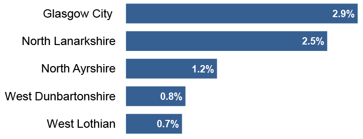
7.10 Across Scotland as a whole 0.1% of all land is derelict. Glasgow City has the largest amount of derelict land in relation to the size of its administrative area (Chart 1). The figures for all councils can be found in Annex Table 3.
General notes - at sections 3 and 4 apply.
Specific note 20 - Glasgow conducted a partial survey in 2021 and some sites were recorded as re-used but no new sites were added due to difficulty with resource for the survey. Dundee City and West Lothian have not updated their survey since 2019 so no new data is available on new site in 2021. Details of survey return rates back to 2015 are shown at Annex D.
Specific note 24 - some authorities reported various impacts of the COVID-19 Pandemic on their survey return in 2021. More details are provided at sections 3 and 4. These impacts should be borne in mind when using and interpreting the figures for these authorities in the year 2021, when comparing the 2021 figure to other years and when interpreting the Scotland total for 2021.
Land areas were derived from the latest local authority boundaries produced by Ordnance Survey.
© Crown copyright and database right (2020). Ordnance Survey (OS Licence number 100024655).
| In Settlement | In Countryside | Total | |||||||||||
|---|---|---|---|---|---|---|---|---|---|---|---|---|---|
| Planning Authority | Area | Percentage of authority's Derelict Land in settlements | Sites | Average Site Size | Percentage of Scottish derelict land in settlements | Area | Percentage of authority's Derelict Land in countryside | Sites | Average Site Size | Percentage of Scottish Derelict Land in countryside | Area | Sites | Average Site Size |
| Aberdeen City | 13 | 100 | 15 | 1 | * | - | - | - | - | - | 13 | 15 | 1 |
| Aberdeenshire | 33 | 70 | 25 | 1 | 1 | 14 | 30 | 3 | 5 | * | 48 | 28 | 2 |
| Angus | 10 | 4 | 12 | 1 | * | 210 | 96 | 12 | 17 | 5 | 220 | 24 | 9 |
| Argyll and Bute | 8 | 22 | 6 | 1 | * | 28 | 78 | 2 | 14 | 1 | 36 | 8 | 4 |
| Clackmannanshire | 5 | 13 | 9 | 1 | * | 36 | 87 | 3 | 12 | 1 | 41 | 12 | 3 |
| Dumfries and Galloway | 504 | 69 | 46 | 11 | 14 | 226 | 31 | 13 | 17 | 6 | 731 | 59 | 12 |
| Dundee City | 14 | 100 | 17 | 1 | * | - | - | - | - | - | 14 | 17 | 1 |
| East Ayrshire | 49 | 6 | 30 | 2 | 1 | 776 | 94 | 35 | 22 | 19 | 825 | 65 | 13 |
| East Dunbartonshire | 2 | 4 | 2 | 1 | * | 41 | 96 | 6 | 7 | 1 | 43 | 8 | 5 |
| East Lothian | 21 | 27 | 10 | 2 | 1 | 56 | 73 | 18 | 3 | 1 | 76 | 28 | 3 |
| East Renfrewshire | 30 | 95 | 20 | 1 | 1 | 2 | 5 | 1 | 2 | * | 32 | 21 | 2 |
| City of Edinburgh | 78 | 98 | 18 | 4 | 2 | 2 | 2 | 1 | 2 | * | 80 | 19 | 4 |
| Falkirk | 142 | 75 | 32 | 4 | 4 | 48 | 25 | 13 | 4 | 1 | 190 | 45 | 4 |
| Fife | 209 | 35 | 102 | 2 | 6 | 389 | 65 | 54 | 7 | 10 | 598 | 156 | 4 |
| Glasgow City | 479 | 93 | 234 | 2 | 14 | 36 | 7 | 5 | 7 | 1 | 515 | 239 | 2 |
| Highland | 133 | 23 | 58 | 2 | 4 | 454 | 77 | 30 | 15 | 11 | 588 | 88 | 7 |
| Inverclyde | 54 | 100 | 41 | 1 | 2 | - | - | - | - | - | 54 | 41 | 1 |
| Loch Lomond and the Trossachs National Park | 3 | 41 | 5 | 1 | * | 4 | 59 | 1 | 4 | * | 6 | 6 | 1 |
| Midlothian | 55 | 64 | 20 | 3 | 2 | 30 | 36 | 11 | 3 | 1 | 86 | 31 | 3 |
| Moray | 7 | 100 | 6 | 1 | * | - | - | - | - | - | 7 | 6 | 1 |
| Na h-Eileanan Siar | - | - | - | - | - | - | - | - | - | - | - | - | - |
| North Ayrshire | 335 | 33 | 78 | 4 | 10 | 687 | 67 | 23 | 30 | 17 | 1,021 | 101 | 10 |
| North Lanarkshire | 816 | 68 | 313 | 3 | 23 | 388 | 32 | 85 | 5 | 10 | 1,204 | 398 | 3 |
| Orkney Islands | - | - | - | - | - | 32 | 100 | 1 | 32 | 1 | 32 | 1 | 32 |
| Perth and Kinross | 11 | 44 | 17 | 1 | * | 14 | 56 | 29 | * | * | 24 | 46 | 1 |
| Renfrewshire | 41 | 32 | 21 | 2 | 1 | 87 | 68 | 2 | 44 | 2 | 128 | 23 | 6 |
| Scottish Borders | 26 | 83 | 40 | 1 | 1 | 5 | 17 | 2 | 3 | * | 31 | 42 | 1 |
| Shetland Islands | 1 | 14 | 1 | 1 | * | 6 | 86 | 5 | 1 | * | 6 | 6 | 1 |
| South Ayrshire | 74 | 79 | 49 | 2 | 2 | 19 | 21 | 7 | 3 | * | 93 | 56 | 2 |
| South Lanarkshire | 126 | 46 | 70 | 2 | 4 | 147 | 54 | 23 | 6 | 4 | 273 | 93 | 3 |
| Stirling | 5 | 5 | 4 | 1 | * | 103 | 95 | 9 | 11 | 3 | 108 | 13 | 8 |
| West Dunbartonshire | 133 | 100 | 54 | 2 | 4 | * | * | 1 | * | * | 134 | 55 | 2 |
| West Lothian | 67 | 22 | 15 | 4 | 2 | 237 | 78 | 28 | 8 | 6 | 304 | 43 | 7 |
| Scotland | 3,483 | 46 | 1,370 | 3 | 100 | 4,078 | 54 | 423 | 10 | 100 | 7,561 | 1,793 | 4 |
General notes - at sections 3 and 4 apply.
Specific note 20 - Glasgow conducted a partial survey in 2021 and some sites were recorded as re-used but no new sites were added due to difficulty with resource for the survey. Dundee City and West Lothian have not updated their survey since 2019 so no new data is available on new site in 2021. Details of survey return rates back to 2015 are shown at Annex D.
Specific note 24 - six authorities reported various impacts of the COVID-19 Pandemic on their survey return in 2021. More details are provided at sections 3 and 4. These impacts should be borne in mind when using and interpreting the figures for these authorities in the year 2021, when comparing the 2021 figure to other years and when interpreting the Scotland total for 2021.
7.11 There were 617 sites listed with building remains as the single issue needing action before any new development. The category with the largest area is listed as having both building remains and possible left over chemicals/substances – 1,578 hectares (25% of total area) across 210 sites.
| Derelict Characteristics | Area | Percentage of Derelict Land with known characteristics | Sites |
|---|---|---|---|
| Building remains | 714 | 11% | 617 |
| Possible left over chemicals/substances | 685 | 11% | 225 |
| Abandoned physical material (stone deposits, rubble etc.) | 521 | 8% | 150 |
| Building remains and possible left over chemicals/substances | 1,578 | 25% | 210 |
| Building remains and abandoned physical material (stone deposits, rubble etc.) | 432 | 7% | 135 |
| Possible left over chemicals/substances and rubble, stone deposits and other material | 1,166 | 18% | 109 |
| Building remains, possible left over chemicals/substances and abandoned physical material (stone deposits, rubble etc.) | 1,314 | 21% | 73 |
| Total Derelict Land with known characteristics | 6,411 | 100 | 1,519 |
| Unknown | 1,150 | Not applicable | 274 |
| Total Derelict Land | 7,561 | Not applicable | 1,793 |
General notes - at sections 3 and 4 apply.
Specific note 20 - Glasgow conducted a partial survey in 2021 and some sites were recorded as re-used but no new sites were added due to difficulty with resource for the survey. Dundee City and West Lothian have not updated their survey since 2019 so no new data is available on new site in 2021. Details of survey return rates back to 2015 are shown at Annex D.
Specific note 24 - six authorities reported various impacts of the COVID-19 Pandemic on their survey return in 2021. More details are provided at sections 3 and 4. These impacts should be borne in mind when using and interpreting the figures for these authorities in the year 2021, when comparing the 2021 figure to other years and when interpreting the Scotland total for 2021.
Contact
Email: planstats@gov.uk