Scottish Shelf Model. Part 6: Wider Domain and Sub-Domains Integration
Part 6 of the hydrodynamic model developed for Scottish waters.
4. Model Setup
4.1 Introduction
In this section, a brief description of the setup of the Shelf and Local hydrodynamic models used for the climatology runs is presented. The results from these models are combined together in an integrated grid (as described in Section 3) for the overlapping periods. The combined results are used for the particle model simulations (described in Section 5), and the development of connectivity indices.
4.2 Shelf model
The Stage 1 report (Scottish Shelf Waters Model) describes the process of setting up the Scottish Shelf Waters FVCOM model from the assembling of data sets, through development of a stable grid, implementation of forcing (tidal, meteorological and river discharge), calibration and validation. The calibration period was March-June 2009 inclusive, while the validation has been carried out over the period May 2008- March 2009.
The model grid has been set up to provide at least 1km resolution around the Scottish coast. The model extends over the whole NW European continental shelf and into the North Atlantic in order to properly represent the tidal regime.
It was found necessary to use the HEATING_CALCULATED option rather than HEATING_ON, within the FVCOM model, in order to get a reasonable evolution of the sea surface temperature ( SST). The sources of met forcing data have been explored, including which variables to download from the Met Office Unified Model output and ERA40/ERA-Interim reanalysis datasets.
During the model calibration phase the bottom friction drag coefficient was varied (although kept constant spatially) and the optimum settings were found to be a roughness length ( z 0) of 0.01m and a minimum drag coefficient of 0.005. The best turbulence closure scheme was GOTM and better results were obtained with 20 vertical levels rather than 10.
The model has then been used to assess the tidal energy resource and, using climatological forcing, the monthly mean circulation pattern. These results have been assessed qualitatively against previously published work and found to be in good agreement.
The most difficult part of the model implementation was to develop a stable grid. In the end, by trial and error and also advice from various sources, including Prof Chen, via CH2M, it was found that the model was sensitive to the connectivity of the mesh (no more than 8 elements must be connected to a single node), steep gradients in bathymetry and issues related to the river forcing. Some smoothing of bathymetry was necessary, near the shelf edge and the Norwegian Trench. At river nodes it was necessary to ensure that the depth was at least 5m in order to ensure that the river inflow could be accepted and propagated into the main body of the model grid.
The model was calibrated by adjusting the number of vertical layers, the bottom friction and the turbulent closure scheme. Validation was carried out by comparison with water surface elevation data, from coastal and offshore tide gauges, current meter data and CTD profiles.
The detailed instructions for running the Shelf Model are provided in a separate document (Model Documentation Report, February 2015) prepared for Marine Scotland training. This includes sections on model installation, data sources, data preparation (pre-processing), running the model and post-processing of the output. It also includes Appendices on using SMS to Prepare Grids (Appendix A), Documentation of MatLab Scripts (Appendix B) and Frequently Asked Questions ( FAQ's, Appendix C).
4.3 Local models
Four local models ( PFOW, ECLH, WLLS and SMB) were developed in Stage 2 (S2) of this project. Each of the four local models have been described in a corresponding technical report. As in the Stage 1 (S1) report, each report describes the process of setting up the model from the assembling of data sets, through development of a stable model, implementation of forcing (tidal, meteorological and river discharge), calibration and validation.
In addition to the challenges with developing a stable model mesh (described in Section 4.2), it was also found necessary to use a nested boundary approach in order to eliminate stability problems in the SMB model. This instigated this approach with all of the local models.
The models were calibrated and validated against available measured water levels, current velocities at current meter locations and transects, and CTD measurements. The calibration was carried out by adjusting the bottom friction and the parameters for the turbulent closure scheme (horizontal and vertical mixing). It was also found necessary to adjust the structure of the vertical layers for the WLLS. The validation was carried out by running the model for a different time interval without any further change to the model parameters.
Each of the local models has been used to determine the mean circulation pattern for the period May to October (Jan - Dec in the case of PFOW and WLLS) using climatological forcing. The derivation of the climatological forcing data is described in detail in the Stage 1 report.
As discussed in Section 2.3, the adopted method for integrating the S1 and S2 models involves one way coupling between the S1 model and the S2 models using the FVCOM nested boundary approach. Further details on the approach used to create the nesting boundary data are presented in Section 4.3.1.
4.3.1 One-way coupling (nesting) approach in FVCOM
There are a number of ways to provide boundaries conditions to an FVCOM model, however for stage 3 the nested relaxation boundary approach has been used. This allows water levels, velocity components, temperature and salinity to be prescribed along the local model boundaries using results from the Shelf model. The relaxation boundary approach was originally developed for use with a regular structured grid model that was coarser than the model that was being nested within it.
This approach has been used for the nesting of the four local models within the Shelf model, it is not always the case that the Shelf model is coarser than the local model at the boundaries but this does not affect the approach.
As the variables from the Shelf model are required to be interpolated onto the local model boundary nodes/elements, the values from the Shelf model cannot ensure mass and volume conservation, in addition the model output from the Shelf model may vary from the local model results in the region of the local model boundary. Therefore a relaxation zone is defined within which a weighting factor is used to proportion the values from the Shelf model and those within the local model to enable a smooth transition between the two models.
Figure 4-1 shows a schematisation of how the relaxation nested boundary works. The blue triangles represent the local model mesh, with the open boundary shown by the light green line, and the boundary elements indicated by the yellow dots. The nodes attached to the boundary elements are indicated by the green dots and are all used for the relaxation boundary. The shelf model mesh is represented by the black-edged triangles, which are slightly finer than the local model (as is the case for the WLLS model western boundary). Water levels, temperature and salinity values are interpolated (triangulation) from the Shelf mesh onto the green dots/ local model nodes along the open boundary and through each of the vertical layers. Likewise the velocity components from the Shelf model are interpolated onto the yellow dots/local model elements adjoining the open boundary.
Whilst the relaxation boundary can be more than one element deep, we have found that one element wide has been sufficient. The boundary nodes/elements each have a weighting factor associated with them, these can be seen in Figure 4-1 Adjacent to each of the nodes/elements on the model boundary.
The weighting factor relates to the proportion of the Shelf model variable to be used compared with the variable already calculated within the local model. For example on the model boundary nodes the factor is 0.75. This means that the elevation at this point is made up of 75% of the values contained within the boundary file (derived from the Shelf model values interpolated onto the boundary nodes) and 25% of the values already calculated within the local model. For the boundary nodes within the model domain, 25% is made up from the values in the boundary file and 75% is taken from the values already calculated within the local model.
For the current speed components, as the relaxation zone is only one element wide then there is only one layer of weights. In this case a weighting factor of 0.5 (or 50%) was used, meaning current components imposed on the model were derived equally between the values contained within the boundary file (derived from the Shelf model values interpolated onto the boundary nodes) and the current speed components already calculated within the local model. This approach smooth's out any discontinuities that may exist between the two models avoiding instabilities that may otherwise occur.
The resulting nesting file is a netcdf file which is produced by the scripts created as part of this project. It contains the data for each of the variables used as well as the weights for the nodes and elements (variables within the netcdf nesting boundary file are called weight_node and weight_elem).
4.3.2 Integrated model results for stage 3
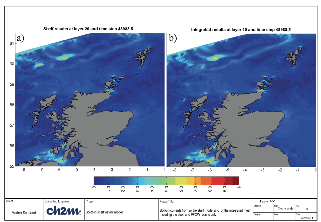
Figure 4-2 shows the combined mesh water levels including the shelf, ECLH, PFOW, WLLS and SMB models, compared with the shelf model only for the same time step in May. Comparison of the shelf and combined mesh for surface, mid-depth and bottom currents are presented in Figure 4-3a to c. Water levels show a seamless transition between the shelf and local models. For the current speeds the transition between the shelf and local models is visible in places, particularly for the bottom currents, however the current speeds in these areas are low <0.2m/s. Figure 4-4 show a comparison of the shelf water levels and the integrated water levels with the shelf and PFOW results only for one time step in January. Figure 4-5a to c show the surface, mid-depth and bottom current speed comparison for the same time step. These results indicate that the method used to combine the model results has been successful.

 the shelf model and b) the integrated mesh including the shelf, ECHL, PFOW, WLLS and SMB results")
 the shelf model and b) the integrated mesh including the shelf, ECLH, PFOW WLLS and SMB results")
 teh shelf model and b) the integrated mesh including the shelf, ECLH, PFOW, WLLS and SMB results")
 the shelf model and b) the integrated mesh including the shelf, ECLH, PFOW, WLLS and SMB results")
 the shelf model and b) the integrated mesh including the shelf and PFOW results only")
 the shelf model and b) the integrated mesh including the shelf and PFOW results only")
 the shelf model and b) the integrated mesh including the shelf and PFOW results only")