Scottish Government Urban Rural Classification 2020
The Scottish Government Urban Rural Classification provides a consistent way of defining urban and rural areas across Scotland. The classification is based upon two main criteria: population and accessibility.
4. Significant Changes with this Release
The Scottish Government Urban Rural Classification was last produced based on 2016 Settlements (2016 version). This updated version is reflective of 2020 Settlements. The differences between the classifications stem from changes to Settlement populations and Settlement boundaries and, to a lesser extent, changes to the road network, the network dataset used, and the software used. There have not been any major changes to the methodologies used to create Settlements or to measure accessibility from the previous version of the Urban Rural Classification. However, the replacement of OS ITN with OS Highways necessitated a change in software used to produce the drive times; from Esri ArcGIS Desktop to Esri ArcGIS Pro. Due to an improved algorithm in ArcGIS Pro Network Analyst – the tool used to produce drive times from settlements - there are very slight changes to the edges of drive time polygons.
Settlement Changes
The classification of a particular area will change if the Settlement population crosses the 3,000, 10,000 or 125,000 thresholds which are used to distinguish between urban and rural areas. Of the 514 Settlements identified in Scotland based on 2020 data, the population of eight had increased or decreased enough by 2020 to pass one of the key population thresholds. These changes are shown in Table 4.1 below.
| Population | |||
|---|---|---|---|
| Settlement Name 2020 | Local Authority | 2016 | 2020 |
| Increased to more than 3,000: | |||
| Danderhall | Midlothian | 2,810 | 3,164 |
| Increased to more than 10,000: | |||
| Dunbar | East Lothian | 9,030 | 10,270 |
| Haddington | East Lothian | 9,130 | 10,350 |
| Nairn | Highland | 9,960 | 10,199 |
| South Queensferry | City of Edinburgh | 9,350 | 10,934 |
| Decreased to less than 3,000: | |||
| Overtown | North Lanarkshire | 3,340 | 2,952 |
| Decreased to less than 10,000: | |||
| Dalgety Bay | Fife | 10,050 | 9,709 |
| Forres | Moray | 10,100 | 9,903 |
These changes in population impacted the total number of centroids used for the drive time calculations. There were a total of 69 centroids used to calculate drive times in the 2016 classification. This increased to 71 centroids for the 2020 classification. The difference was due to the addition of removal of two Settlements centroids for Dalgety Bay and Forres and the addition of four Settlements centroids for Dunbar, Haddington, Nairn, and South Queensferry. The population of Dalgety Bay and Forres decreased beneath the threshold of 10,000 between 2016 and 2020, making them ineligible for inclusion in the drive time calculations. The populations of Dunbar, Haddington, Nairn, and South Queensferry increased above the 10,000 threshold between 2016 and 2020, making them eligible for inclusion in the drive time calculations. The biggest impact on service areas appears to be the removal of Forres, which has decreased accessibility in this part of the country, and the addition of Haddington and, in particular, Dunbar, which has noticeably increased accessibility in this part of the country.
Analysis of Data Zone changes
One of the most common uses of the Classification is the assignment of urban rural categories to Data Zones, which is the core geography used for the dissemination of small area statistics in Scotland[2]. It is therefore interesting to note the changes in category assignments between versions of the classifications, particularly Data Zones which swap between the 2-fold categories of Urban Scotland and Rural Scotland. There are 6,976 Data Zones 2011 in Scotland. Each Data Zone has been assigned to an urban rural category based upon the location of its population weighted centroid. There are twelve which have changed from being classified as Rural in 2016 to Urban in 2020 (i.e. 0.17% of all Data Zones), and seventeen which have changed from Urban in 2016 to Rural in 2020 (i.e. 0.24% of all Data Zones). Twenty of these Data Zones have changed due to Settlement boundary changes, and the remaining nine have changed due to being located within Settlements which have passed a population threshold since 2016 (see Table 4.1 above).
Road Network Changes
Due to the fact that the drive time analyses are based on average speeds applied by road type to the whole country, the results will not be impacted by improvements made to sections of existing roads, e.g. widening a motorway to ease localised congestion. Unless there are new roads, the network used for the 2020 Classification will behave exactly the same as in the 2016 Classification, as both are based on the same average speeds. There were no noticeable drive time boundary changes due to any new roads. Please note; the road network dataset used in the 2016 Classification (OS Integrated Transport Network (ITN)) has been retired. The 2020 Classification was produced using the replacement product; OS Highways.
Software Changes
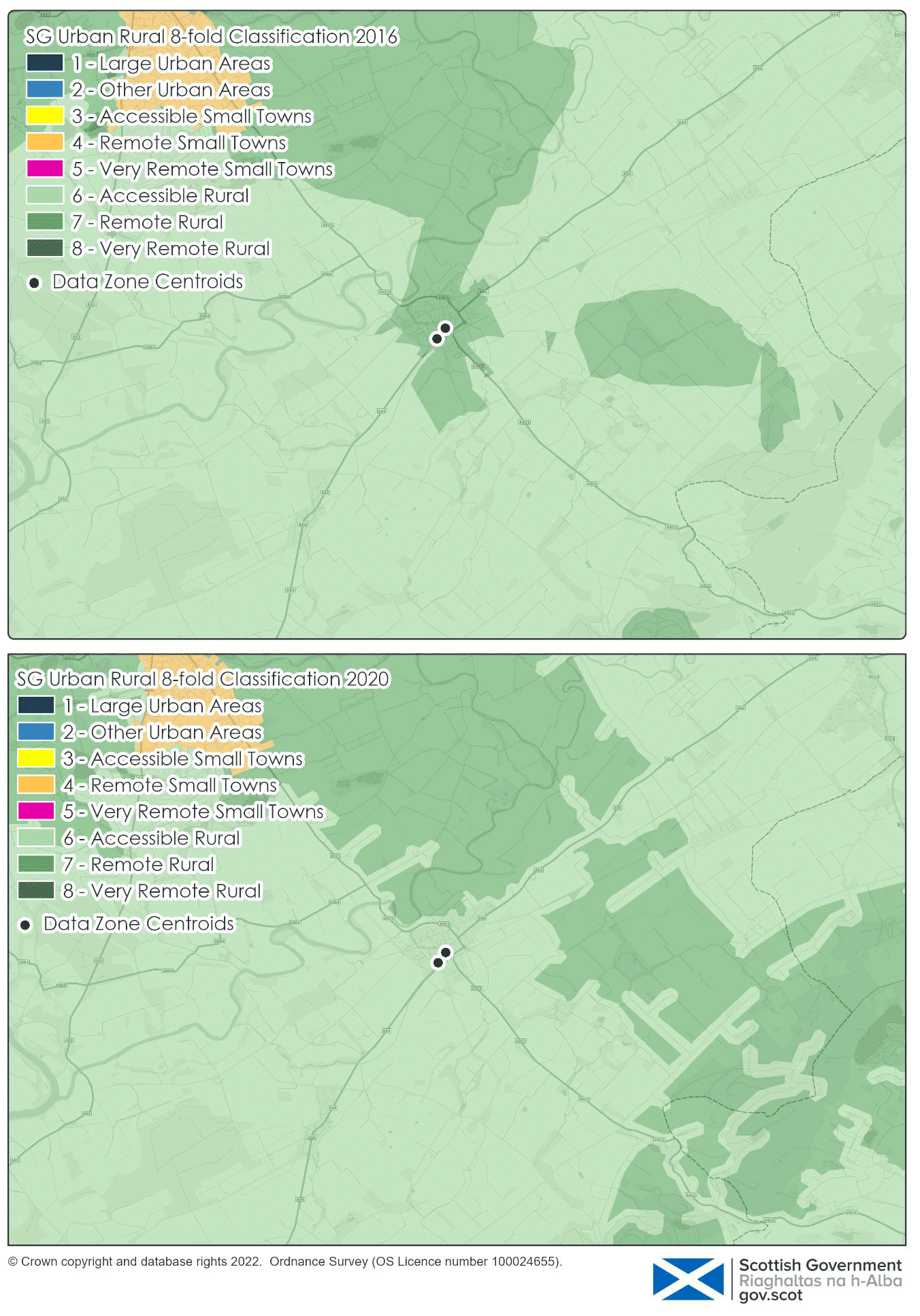
The change from OS ITN to OS Highways necessitated a change in software; from Esri ArcGIS Desktop to Esri ArcGIS Pro. Testing in each network in each software was undertaken to ensure transferability of the drive time methodology. Where possible, parameters were matched to the equivalent parameters in ArcGIS Pro. However, due to some improvements to the underlying Network Analyst algorithm in the Esri ArcGIS Pro software, there are some changes to the edges of the drive time polygons produced. As a result of these edge changes, 58 Data Zones have changed category in the 8-fold Classification (i.e. approx. 0.8% of all Data Zones). However, on investigation, these changes appear to present a more realistic view of accessibility.
An example of this is Coupar Angus (Figure 4.2). In the 2016 Urban Rural Classification, the two Data Zones in Coupar Angus town were classed as Remote Rural, and the countryside areas surrounding Coupar Angus town were classed as Accessible Rural. Coupar Angus town is situated on the A94, which is the primary route in the area for access to two Settlements with a population greater than 10,000 people; Perth and Forfar. The countryside areas along the A94 up to the boundary of Coupar Angus town are all defined as Accessible Rural. It is perhaps unrealistic that Coupar Angus town could be defined as more rural than the countryside areas around it.
In the 2020 Urban Rural Classification, the Accessible Rural area encompasses the length of the A94 and therefore also encompasses Coupar Angus town, whereas the surrounding countryside areas are defined as Remote Rural. This is likely a more realistic representation of this area, as the town – being on a main road and therefore having a higher average speed – should be more accessible than the surrounding countryside areas.