Scottish Government Urban Rural Classification 2020
The Scottish Government Urban Rural Classification provides a consistent way of defining urban and rural areas across Scotland. The classification is based upon two main criteria: population and accessibility.
2. Overview
The Scottish Government Urban Rural Classification provides a consistent way of defining urban and rural areas across Scotland. The classification is based upon two main criteria: (i) population, as defined by the National Records of Scotland (NRS), and (ii) accessibility, based on drive time analysis to differentiate between accessible and remote areas in Scotland. The classification is available in multiple forms, including a 6-fold classification which distinguishes between urban, rural, and remote areas through six categories, and an 8-fold classification which further distinguishes between remote and very remote regions.
The population criteria is derived from the Settlements dataset produced by NRS, which defines areas of contiguous high density postcodes that make up a Settlement. Using the population thresholds of 125,000, 10,000 and 3,000 people, Settlements can be grouped into the following categories:
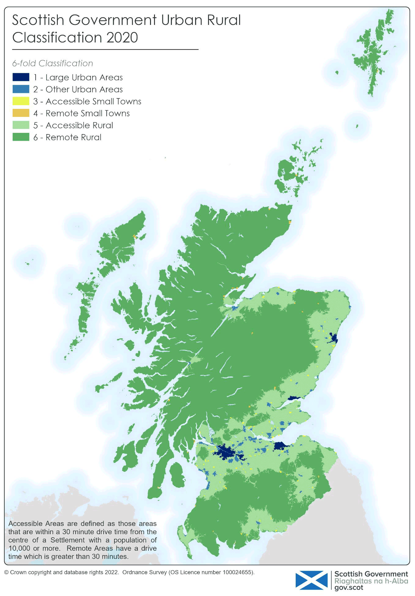
(1) Large Urban Areas - populations of 125,000 or more
(2) Other Urban Areas - populations of 10,000 to 124,999
(3) Small Towns - populations of 3,000 to 9,999
(4) Rural Areas - populations less than 3,000
Accessibility is measured in terms of drive times to an urban area. This is done by calculating 30 and 60 minute drive times from the population weighted centroids of Settlements with a population of 10,000 or more (i.e. Large and Other Urban Areas). The results allow areas to be classified in terms of accessibility by the following categories:
(1) Accessible - Areas within a 30 minute drive time of a Settlement with a population of 10,000 or more.
(2) Remote - Areas that are more than a 30 minute drive time (6-fold classification), or areas that have a drive time between 30 and 60 minutes (8-fold classification) from a Settlement with a population of 10,000 or more.
(3) Very Remote - Areas that are more than a 60 minute drive time from a Settlement with a population of 10,000 or more (8-fold classification only).
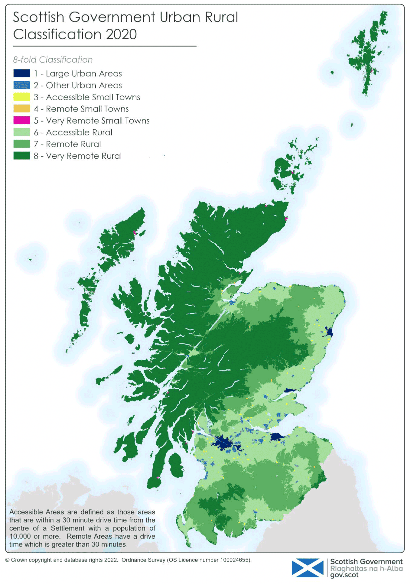
By combining both the population and accessibility measures, a Scotland-wide Urban Rural Classification is defined. Categories of the 6- and 8-fold classifications are shown in Tables 2.1 and 2.2 below.
| Class | Class Name | Description |
|---|---|---|
| 1 | Large Urban Areas | Settlements of 125,000 people and over. |
| 2 | Other Urban Areas | Settlements of 10,000 to 124,999 people. |
| 3 | Accessible Small Towns | Settlements of 3,000 to 9,999 people, and within a 30 minute drive time of a Settlement of 10,000 or more. |
| 4 | Remote Small Towns | Settlements of 3,000 to 9,999 people, and with a drive time of over 30 minutes to a Settlement of 10,000 or more. |
| 5 | Accessible Rural Areas | Areas with a population of less than 3,000 people, and within a 30 minute drive time of a Settlement of 10,000 or more. |
| 6 | Remote Rural Areas | Areas with a population of less than 3,000 people, and with a drive time of over 30 minutes to a Settlement of 10,000 or more. |
| Class | Class Name | Description |
|---|---|---|
| 1 | Large Urban Areas | Settlements of 125,000 people and over. |
| 2 | Other Urban Areas | Settlements of 10,000 to 124,999 people. |
| 3 | Accessible Small Towns | Settlements of 3,000 to 9,999 people, and within a 30 minute drive time of a Settlement of 10,000 or more. |
| 4 | Remote Small Towns | Settlements of 3,000 to 9,999 people, and with a drive time of over 30 minutes but less than or equal to 60 minutes to a Settlement of 10,000 or more. |
| 5 | Very Remote Small Towns | Settlements of 3,000 to 9,999 people, and with a drive time of over 60 minutes to a Settlement of 10,000 or more. |
| 6 | Accessible Rural Areas | Areas with a population of less than 3,000 people, and within a drive time of 30 minutes to a Settlement of 10,000 or more. |
| 7 | Remote Rural Areas | Areas with a population of less than 3,000 people, and with a drive time of over 30 minutes but less than or equal to 60 minutes to a Settlement of 10,000 or more. |
| 8 | Very Remote Rural Areas | Areas with a population of less than 3,000 people, and with a drive time of over 60 minutes to a Settlement of 10,000 or more. |
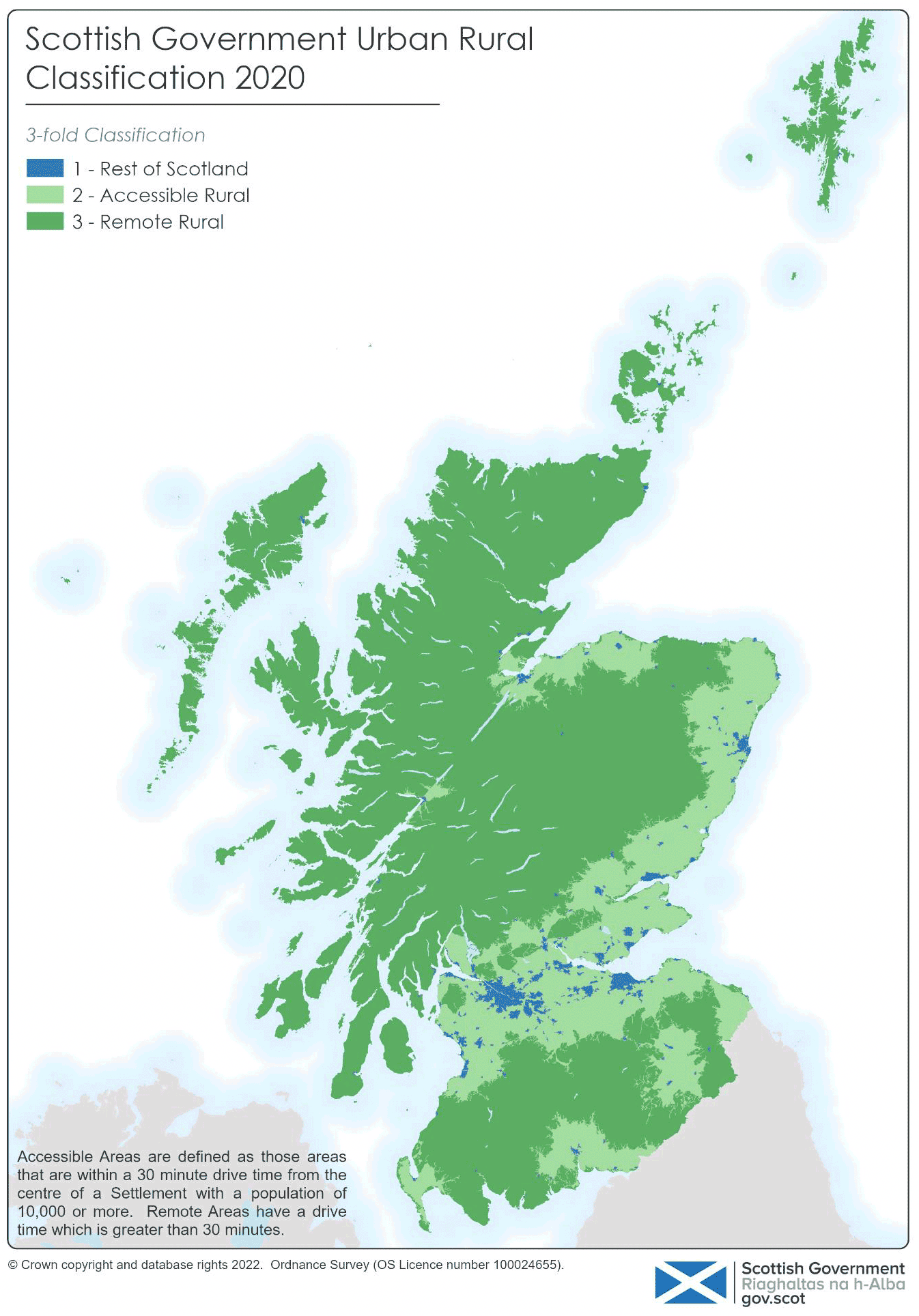
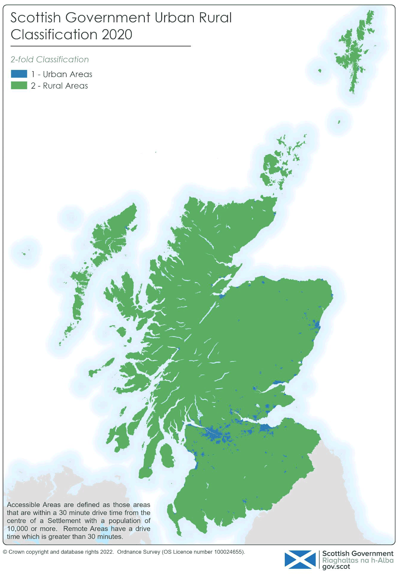
The Scottish Government core definition of rurality classifies areas with a population of fewer than 3,000 people to be rural. The Scottish Government Urban Rural Classification can be collapsed to this core definition, to create a 2-fold classification (see Table 2.3). Categories 5 and 6 are rural and categories 1 to 4 make up the rest of Scotland (Urban Areas and Small Towns).
(1) Rest of Scotland – (1) Large Urban Areas, (2) Other Urban Areas, (3) Accessible Small Towns, and (4) Remote Small Towns.
(2) Rural Scotland – (5) Accessible Rural and (6) Remote Rural Areas.
| UR 8-fold Class | UR 6-fold Class | UR 3-fold Class | UR 2-fold Class |
|---|---|---|---|
| 1 | 1 | 1 | 1 |
| 2 | 2 | 1 | 1 |
| 3 | 3 | 1 | 1 |
| 4 | 4 | 1 | 1 |
| 5 | 4 | 1 | 1 |
| 6 | 5 | 2 | 2 |
| 7 | 6 | 3 | 2 |
| 8 | 6 | 3 | 2 |
An alternative grouping of categories can be used to distinguish between Accessible and Remote areas. Settlements containing fewer than 10,000 people, or areas of Scotland not included in a Settlement, with a drive time of over 30 minutes to a Settlement of 10,000 or more are defined to be remote areas. These are categories 4 and 6 in the 6-fold classification.
(1) Accessible – (1) Large Urban Areas, (2) Other Urban Areas, (3) Accessible Small Towns, and (5) Accessible Rural
(2) Remote – (4) Remote Small Towns and (6) Remote Rural Areas
Versions
The Scottish Government hold the current and previous versions of the classification, as listed below. All previous versions are readily available and, depending on the analysis, users may want to apply these or the current version to historic datasets. Users are encouraged to reference the version of the Urban Rural Classification used.
The classification was last produced based on 2016 Settlements, and named the '2016 Scottish Government Urban Rural Classification'. This updated version is reflective of 2020 Settlements, and has been named the '2020 Scottish Government Urban Rural Classification'.
Note; the classification was previously called the Scottish Household Survey (SHS) Urban Rural Classification. Its original name reflected the fact that it was developed within the context of the SHS. To reflect its wider use beyond SHS, its name was been changed to the Scottish Government Urban Rural Classification.
- 2020 Scottish Government Urban Rural Classification
- 2016 Scottish Government Urban Rural Classification
- 2013-2014 Scottish Government Urban Rural Classification
- 2011-2012 Scottish Government Urban Rural Classification
- 2009-2010 Scottish Government Urban Rural Classification
- 2007-2008 Scottish Government Urban Rural Classification
- 2005-2006 Scottish Executive Urban Rural Classification
- 2003-2004 Scottish Executive Urban Rural Classification
- 2001 Scottish Household Survey Urban Rural Classification (6-fold only)
Comparison with other UK classifications
Different urban rural definitions are required as the nature of rurality is different in each country. Separate definitions in Scotland, Northern Ireland, and England and Wales have been in use for a number of years. A review paper is available which provides more information on the Northern Ireland 2015 classification. A definition for England and Wales was introduced in 2004 and most recently updated in 2011. For more information see https://www.gov.uk/government/statistics/2011-rural-urban-classification.
 Map 2.2: Scottish Government 6-fold Urban Rural Classification 2020