Sandeel fishing consultation: strategic environmental assessment - draft environmental report
The draft environmental report produced from the strategic environmental assessment on proposals to close fishing for sandeel in all Scottish waters.
2. Sandeel management measures
2.1 Background
2.1.1 Sandeel represent the most abundant species group in the North Sea and play a key role in North Atlantic marine food webs.[14] Variations in the abundance and availability of sandeel can have important effects on both ends of marine food web[15] (top-down regulation of lower trophic levels and bottom-up effects on marine predators). This background section provides an overview of trends and drivers of sandeel abundance as well as placing sandeel in the context of the wider marine environment. Further detail can be found in the report 'Review of Scientific Evidence on the Potential Effects of Sandeel Fisheries Management on the Marine Environment' which can be found in the consultation package.
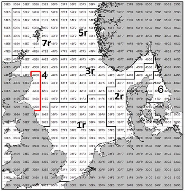
2.1.2 Sandeel fisheries in European waters are currently assessed and managed in the North Sea only (Figure 2). Due to the lack of data and the current absence of a fishery, sandeel on the west coast of Scotland are not assessed. The largest of the sandeel stocks in Scottish waters is Sandeel Area 4 (SA4), and this is the only one with an active fishery.
2.1.3 Since 2008, the Scottish Government Marine Directorate has conducted an annual winter dredge survey at grounds off the Firth of Forth and Turbot Bank in SA4. Data from this survey as well as earlier sampling efforts dating back to 1993 show a high degree of fluctuation in standing stock biomass (SSB) with SSB dropping below the precautionary spawning biomass level in some years (Figure 2).
2.1.4 Causes of variation in sandeel abundance are numerous and are driven by natural mortality, which is influenced by factors such as environmental change (temperature effects, regime shifts) and top-down processes (trophic regulation by marine predators), in addition to fishing mortality.
2.1.5 Several species of seabird are dependent on sandeel as a prey source during the breeding season, including black-legged kittiwake Rissa tridactyla, common guillemot Uria aalge, black guillemot Cepphus grille, Atlantic puffin Fratercula arctica, and Northern gannet Morus bassanus[16] and declining populations of sandeel and other small fish may be a contributing factor to the decline of seabirds. For example, in 1993 there was a measurable, negative effect of the fishery on the sandeel stock (local depletion) in the western part of Area 3, which coincided with a reduction in breeding success of seabirds, especially kittiwakes.[17] The ability of seabirds to predate upon sandeel will depend on both the absolute numbers of sandeel (stock biomass) and the availability of sandeel to seabirds. Seabirds are constrained in both the distance from nest sites that they can forage and the depth in the water column that they can reach.
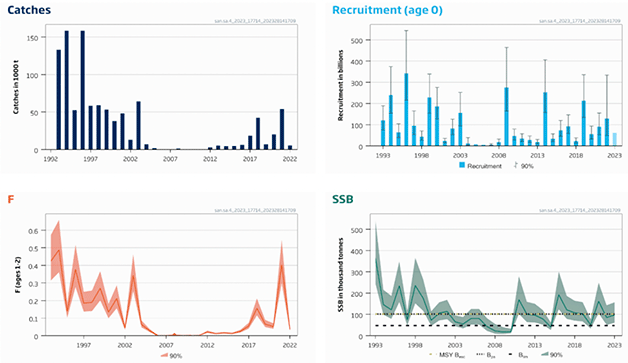
The 'Catches' panel shows catches of sandeel in 1000 tonnes per year. The'Recruitment (age 0) panel shows the number of age 0 recruits that enter the fishery per year, with error bars depicting the 90% confidence intervals. In this panel the 2023 value corresponds to the geometric mean for the period 2012-2021 as this assessment is incomplete. The 'F' panel shows fishing mean mortality (F) of sandeel aged 1 and 2 per year. 90% confidence intervals are depicted by the shaded region around the mean. Panel 'SSB' shows the mean spawning stock biomass (SSB i.e. the biomass of all available sandeel) in Sandeel Area A4 in thousand tonnes. The shaded region depicts the 90% confidence interval around this mean. The dotted black line shows the precautionary biomass level (Bpa), below which stocks levels are at risk. The dotted yellow line shows the rate of fishing mortality consistent with achieving Maximum Sustainable Yield (MSY). The dashed black line shows the biomass limit (Blim) below which stocks rae considered to suffer from impaired recruitment. (ICES, 2023).
Sandeel also comprise a key component of the diets of marine mammals including grey seals Halichoerus grypus and harbour seals Phocu vitulina, as well as cetaceans such as minke whale Balaenoptera acutorostrata[18] and harbour porpoise Phocoena phocoena.[19] Harbour seals are experiencing regional population declines and one potential contributing factor is a reduction in the availability of prey species, including sandeel in regions where they are experiencing decline.[20] Lower availability of sandeel has been linked with increased risk of starvation in harbour porpoise.[18]
2.1.6 Sandeel is also a prey species for some predatory fish species (Atlantic cod Gadus morhua, whiting Merlangius merlangus, haddock Melanogrammus aeglefinus and saithe Pollachius virens).[21][22] In addition to trophic interactions with sandeel, other marine fish may interact with the sandeel fishery via catching patterns. Whiting and mackerel Scomber scombrus are caught as bycatches in the sandeel fishery and whiting aggregate at sites of high sandeel abundance.[23]
2.2 Effects of sandeel management measures to date
2.2.1 North Sea sandeel is jointly managed stock between the UK and the EU. Under the UK/EU Trade and Cooperation Agreement (TCA), the UK has a 2.97% share and the EU a 97.03% share of the Parties' combined sandeel quota in 2023. The Total Allowable Catch (TAC) is set during the in-year consultations, followed by the ICES advice release. As a result of the negotiations this year, the TAC has been set at 194,367 tonnes[24] which is 3% lower for areas 1r and 4[25] (UK waters) than the ICES advice.
2.2.2 Under the UK/EU Trade and Cooperation Agreement (TCA),[26] and during a transition period lasting until 30 June 2026, the UK and the EU have full mutual access to their respective EEZs (i.e., 12 – 200 nautical miles); as well as access to specific English, Welsh and Channel Island waters in the 6-12 nautical mile area. Sandeel is an important fishery to some EU member states, in particular Denmark, who regularly fish the stock in UK waters.
2.2.3 Due to their ecosystem importance, sandeel were made a Scottish priority marine feature[27] and given their limited movements, various Nature Conservation (NC) MPAs have been designated with sandeel as a key conservation target (Figure 3). In 2014, following two public consultation exercises, the North West Orkney, the Mousa to Boddam and the Turbot Bank NC MPAs were designated under the Marine (Scotland) Act 2010 and Marine and Coastal Access Act 2009 to protect sandeel. Designations were based primarily on assessment of peer-reviewed scientific evidence, using the process as set out in the Scottish MPA Selection Guidelines. These areas demonstrated a regular presence of sandeel and were particularly important to adult aggregations (Turbot Bank), recruitment (Shetland) and/or larval export (NW Orkney, Turbot Bank), and had geophysical attributes supportive to sandeel populations, based on evidence from historic trawl, dredge and continuous plankton recorder (CPR) surveys, particle size analysis (PSA) and oceanographic modelling.
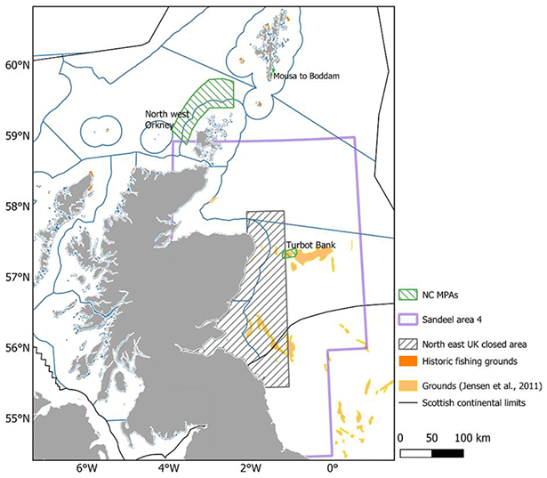
2.2.4 As a precautionary measure to safeguard marine top predators, particularly seabirds at internationally important colonies in and around the Firth of Forth, an area off the east coast of Scotland, from Rattray Head to St Abbs, was closed to industrial fishing for sandeel in 2000. The extent of the area is indicated in Figure 3 and covers about 27% of SA4 fishing grounds historically targeted by the fishery.[28]
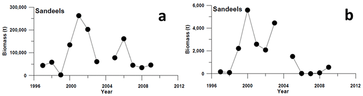
2.2.5 Evidence establishing the effect of the fishery closure is limited. The Marine Directorate led studies that compared measures of sandeel abundance before and during the closure,[29][30] relying on sandeel sampled during the summer months using a variety of gears (demersal trawls, pelagic trawls, acoustic surveys, dredges, and grabs). A substantial increase in sandeel biomass was observed in the Firth of Forth in 2000 and 2001 (i.e., the first years following the closure). This increase was found to be associated with high levels of recruitment in 1999 and 2000, combined with the lack of fishing pressure. However, the cause of the 2000 increase in sandeel biomass (high recruitment in 1999 and 2000) is unclear as it preceded any increase in the local spawning stock, so cannot be attributed to the closure. Since 2001, sandeel biomass has declined to reach levels in 2008-2009 that were similar to those observed in 1997 and 1998 when the sandeel fishery in the area was active[31] (Figure 4).
2.2.6 Evidence shows that causes of variation in natural mortality played a more prominent role than fishing mortality in shaping sandeel abundance in Scottish waters and as these causes of variation are rarely accounted for, an effect of fishing pressure on sandeel abundance is rarely observed. However, while results should be considered with caution, age 1 sandeel seem to have a higher survival rate in the current fishery closure.
2.2.7 While the effect of a fishery closure may be difficult to observe in a changing environment, sandeel are likely to benefit from spatial management measures aimed at reducing fishing mortality due to their life-long attachment to particular sand banks and limited dispersal and movements. As represented in Figure 5, variations in Spawning Stock Biomass (SSB) are mainly driven by variability in recruitment.
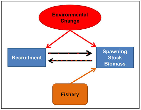
2.2.8 Here recruitment, to a certain extent, is contingent on the size of the reproductive population (SSB). Environmental change has a multitude of effects (direct and indirect) and can affect SSB through the maturation process (see section 3.2.1 of the report 'Review of Scientific Evidence on the Potential Effects of Sandeel Fisheries Management on the Marine Environment'); recruitment through the effects on phenology (spawning date, incubation time, hatching date); and trophic mismatch between sandeel hatching and the availability of their copepod prey. The fishery can directly affect SSB through fishing mortality and there is some evidence that it may also indirectly affect recruitment by decreasing SSB (through mortality) or by reducing the abundance of large individuals which have a higher fecundity and may spawn earlier (which in turn may affect trophic mismatch and interact with climate change effects). A fishery closure may therefore promote sandeel resilience to climate change by limiting variation in SSB that might affect recruitment and ensuring that sufficient large, early spawning individuals are present in the population. In accordance, a modelling study found that population collapse was more likely under exploitation.[32]
2.3 Proposals to close fishing for sandeel in all Scottish waters
2.3.1 The Scottish Government has committed to considering what measures could be introduced to better manage fishing for sandeel in Scottish waters, with an aim to benefit both North Sea sandeel stocks, and the wider ecosystem.
2.3.2 Based on the scientific evidence available there is evidence that extending the existing closure to all Scottish waters may benefit the stock and wider ecosystem.
2.3.3 Taking into consideration the pressures facing key predator species such as seabirds, marine mammals and predatory fish stocks, the Scottish Government therefore proposes to consult on proposals to extend the existing sandeel area closure to all Scottish waters. This proposal is informed by the potential benefits to the wider marine ecosystem that such a measure could bring. These include benefits to sandeel, seabirds, marine mammals, and other fish species. The extension of the current closed area to all Scottish waters would also benefit several of Scotland's Marine Protected Areas (MPAs) for which sandeel are a protected feature, and would contribute to achievement of GES for seabirds and marine mammals.[33]
2.3.4 Sandeel in area 4 is a single stock. The TAC for sandeel area 4 covers the whole area, without taking into account the existing closure within the area, therefore some fishing effort is currently displaced without regard to the potential effects on local depletion.
2.3.5 Consideration was given to possible further displacement of fishing effort as a result of an extension to the closed area. It is possible that closure of the sandeel fishery in all Scottish waters would mean that some activity is displaced into the portion of sandeel area 4 that extends into English waters. However, it is difficult to quantify to what extent fishing patterns in the area will change as a result of displacement, or if fishing will simply decrease. Displacement can be assessed using VMS data which is already available for all vessels in the fishery. Furthermore, the UK government launched a consultation on the management of sandeel in English waters on 7 March 2023. This proposes a closure of sandeel fishing in English waters within the North Sea. If this proceeds, then this would mitigate the risk of displacement of activity into English waters. On the other hand, closure of the sandeel fishery in English waters may risk displacement of fishing activity into Scottish waters if the option to close the sandeel fishery in Scottish waters is not pursued. Catching levels are set in line with the agreed TAC level flowing from the UK-EU Bilateral Agreement, meaning that there will be no increased fishing pressure in the area as a whole.
2.3.6 Sandeel play a key role in North Atlantic marine food webs and variations in their abundance and availability can have important effects across the marine food web. Sandeel are an important food source for globally important Scottish seabird populations that are currently facing a range of pressures. Some species, such as black-legged kittiwake and Arctic skua Stercorarius parasiticus, are considered highly sensitive to sandeel availability.[34] Sandeel are also an important food source for fish species and marine mammals, including locally declining harbour seal populations.[35] The total stock biomass of sandeel has shown an overall decline over the last three decades. Climate change has the potential to further affect sandeel abundance and their availability to marine predators.
2.3.7 We propose extension of the closure to cover all Scottish waters, due to the potential benefits that it may bring to sandeel stocks (which continue to be depleted) as well as the wider marine environment.[36] We propose that the closure is effective year-round, and that it should be permanent until revoked. Full consideration to all options will be given following the consultation.
2.4 Policy context overview of the proposals to close fishing for sandeel in all Scottish waters
2.4.1 The Scottish Government has commitments under the UK Marine Strategy to collaborate with the other UK administrations to assess, monitor and measure progress towards Good Environmental Status. This includes descriptors for biodiversity and commercial fish.[37] The Scottish Government's key regional platform for collaboration with neighbouring countries on marine biodiversity is OSPAR (the Convention for the Protection of the Marine Environment in the North-East Atlantic), where we participate as part of the UK and take action developed under this forum to protect and conserve the marine ecosystem and biodiversity.[38] Under the Joint Fishery Statement of the Fisheries Act 2020 the Scottish Government is committed to delivering sustainable management of fisheries that takes account for the protection of biodiversity and healthy functioning marine ecosystems.[39]
2.4.2 Given the importance of sandeel to the wider ecosystem and the subsequent benefit provided by the species in aiding long-term sustainability and resilience of the marine environment, it remains an over-arching and long-held Scottish Government position not to support fishing for sandeel in Scottish waters, which is reflected in Scotland's Future Fisheries Management Strategy.[40] This position was emphasised in June 2021 when the Cabinet Secretary for Rural Affairs and Islands committed in Parliament to considering what management measures could be put in place to better manage the North Sea sandeel fishery in Scottish waters.
Contact
Email: sandeelconsultation@gov.scot