Outer Hebrides Inshore Fisheries Pilot: year one report
The OHIFP is a stakeholder-led project developed collaboratively by the fishing industry, the scientific community and Scottish Government to test approaches to fisheries management within a significant area of sea to the east of the Outer Hebrides. This report summaries the first years findings.
2. Introduction
Scotland's RIFG network consists of non-statutory bodies that aim to improve the management of our inshore fisheries. They enable fishers to work closely with their peers and the Scottish Government, as well as providing a strong voice in the wider marine planning context.
This aspiration, to enable locally-led management, was exemplified by the 2017 Inshore Fisheries Pilots Initiative which signalled a commitment to enrich the evidence base on which fisheries management decisions are made, streamline governance and promote stakeholder involvement.
The FFM Strategy noted strong support for the RIFG network with the intention that it continue to evolve into Scotland's primary mechanism for delivering locally-led fisheries management initiatives.
2.1 Proposing an Inshore Fisheries Pilot
In November 2017 the Inshore Fisheries Pilots Initiative consulted on a number of stakeholder-proposed pilot projects. This included one from the Outer Hebrides RIFG, which sought, primarily, to limit the number of creels that a commercial fishing vessel may deploy.
The proposal stated that creel numbers in the waters around the Outer Hebrides had been steadily rising for 20 years and had reached a point where catch rates were declining. This was of particular concern as the Hebrides remain heavily dependent on inshore fisheries and the health and status of the shellfish stocks are critical to supporting the local economy.
At consultation, stakeholder opinion on the proposal reflected a desire to challenge the status quo, where a commercial licence imposes few national restrictions on static gear fishing. Many stakeholders acknowledged the general trend towards increasing creel fishing effort leading to fishers setting gear out in order to 'ring fence' certain areas of sea bed, thus excluding competitors. This combined with a lack of output controls, such as quotas, for key shellfish species posed questions about the impact of fishing at current levels on stock health.
The consultation did highlight some potential challenges with implementing such a large scale pilot, including that the proposal did not differentiate different types of creel and therefore would not delineate the fishing pressures on respective shellfish species. In general, smaller vessels (up to approximately 8 metres) tend to target velvet crab and lobster on rocky seabed, down to 30 metres depth. Larger vessels tend to work deeper waters with a sandy bottom, targeting brown crab. Vessels of between 8 and 15 metres may also target Nephrops on muddy seabed at depths of 60 to 100 metres.
It was also highlighted that the Pilot only proposed management for static gear and that vessels trawl fishing for Nephrops were not considered or included.
Marine Scotland chose to progress the Pilot, acknowledging strong support expressed at consultation and also a well-defined, proactive group of active fishers keen to contribute to its development. It was considered that this group would be well placed to identify a level at which a profitable business could be run, while addressing the pressure to deploy ever more creels in order to combat declining catch rates.
2.2 Aims of the Pilot
- To address concerns that shellfish catch rates are declining.
- To enable the fishing fleet to work together, identifying an approach to static gear fishing that will limit the increase of fishing effort.
- To feed into the discussion on tracking solutions for the Scottish static gear fleet, under the wider Modernisation of the Inshore Fleet Programme.
- To test a locally-led approach to fisheries management.
2.3 Development and Implementation
The Outer Hebrides RIFG established a Pilot sub group in 2018 that included active fishers, Marine Scotland, University of St. Andrews and Comhairle Nan Eilean Siar. Key areas for discussion included:
- The Pilot area.
- Basis on which to allocate creel limits.
- Permissible soak time.
- Monitoring and compliance.
- Legislative mechanism.
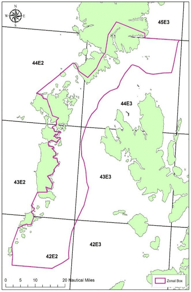
Following discussion led by active fishers, it was agreed that the Pilot area would be reduced from the extensive area detailed in the initial proposal to an area to the east of the Hebrides where anecdotal evidence suggested fishing was most intense (Figure 1). To address fishing effort, creel limits based on vessel length categories were agreed, along with a maximum soak time of two weeks (Table 1). The Pilot was also to be used as means to trial a vessel tracking solution. This would serve to enrich the available scientific evidence base as well as enable learning on how such a system might aid governance in the future.
| Vessel Overall Length | Maximum No. of Creels |
|---|---|
| <8 meters | 800 |
| 8-10 meters | 1,200 |
| 10-12 meters | 1,500 |
| >12 meters | 1,800 |
Vessels identified via analysis of their track record, as eligible to deploy creels in the Pilot area were issued derogation letters in October 2020. Applications were considered in line with policy designed to give fair consideration to new entrants, inactive fishers and nomadic vessels from other areas who fished within the Pilot area for part of their time. A total of 142 derogations have been issued to date.
The Pilot commenced on 5th November 2020, enabled by a licence condition prohibiting creel fishing - by those vessels not in possession of a derogation - within an area to the east of the Outer Hebrides. The licence condition also established conditions of access to the area, including the agreed creel limits, maximum soak time, and a provision that derogated vessels may be required by Marine Scotland to carry a vessel tracking solution.
2.4 Key Work Streams
Outer Hebrides RIFG
The RIFG maintain a close dialogue with fishers across their network through regular committee meetings, taking note of both positive and negative observations of the Pilot. This information is shared with Marine Scotland on a regular basis (Section 3).
Marine Scotland Science
In support of the Pilot, Marine Scotland Science carried out analyses of the best available data between 2017 and 2021, in order to consider its relative merits and assess fishing activity in and around the area (Section 4).
University of St Andrews
Following on from the Scottish Inshore Fisheries Integrated Data System (SIFIDS) project led by the University of St Andrews, a tracking solution was fitted to 40 vessels participating in the Pilot (Section 5). Key objectives were:
- To inform possible future development of this data collection system and the functionality required for scientific evidence gathering and governance.
- To provide highly spatially and temporally resolved vessel track data for analysis.
- To combine that data with an algorithm that will infer where gear is being shot and hauled, in turn enabling estimation of soak time.
- To increase resolution of data by coupling it with the Catching App, enabling highly spatially and temporally resolved LPUE data for a section of the fleet, while supporting fishers promptly and accurately submitting landings data to Marine Scotland.
- To enable stakeholders to view their own data.
Marine Scotland Compliance
To carry out routine monitoring of the Pilot area on a risk-assessed basis to detect and deter breaches of the licence condition (Section 6).
Contact
Email: inshore@gov.scot