National Planning Framework 4
National Planning Framework 4 (NPF4) is our national spatial strategy for Scotland. It sets out our spatial principles, regional priorities, national developments and national planning policy. It should be read as a whole and replaces NPF3 and Scottish Planning Policy.
Annex F – Glossary of definitions
20 minute neighbourhood
A flexible approach to assessing our places against the concept of local living. A method of achieving connected and often compact neighbourhoods designed in such a way that people can meet the majority of their daily needs within a reasonable distance of their home preferably by sustainable and active travel methods. The principle can be adjusted to include varying geographical scales from cities and urban environments, to rural and island communities. Housing would be planned together with local infrastructure including schools, community centres, local shops and health and social care to significantly reduce the need to use unsustainable methods of travel, to prioritise quality of life, help tackle inequalities, increase levels of health and wellbeing and respond to the climate emergency.
4G
4G is the fourth generation of mobile phone technology, following 2G and 3G. 2G technology was suitable for making calls and sending text messages, while 3G makes it possible to access the internet more effectively through devices such as a mobile, tablet or laptop. It’s ideal for services that demand more capacity, like video streaming, mapping and social networking sites.
5G
5G is much faster than previous generations of wireless technology. 5G also offers greater capacity, allowing thousands of devices in a small area to be connected at the same time.
The reduction in latency (the time between instructing a wireless device to perform an action and that action being completed) means 5G is also more responsive. Together these features make 5G highly relevant for industrial applications.
The connectivity and capacity offered by 5G is opening up the potential for new, innovative services while mobile spectrum can be used in more effective ways.
Affordable home/affordable housing
Good quality homes that are affordable to people on low incomes. This can include social rented, mid-market rented, shared-ownership, shared-equity, housing sold at discount (including plots for self-build), self-build plots and low cost housing without subsidy.
Agent of change principle
Where an application is made for development which is likely to be affected by noise from existing development such as, but not limited to, music venues, manufacturing or industrial sites, large retail outlets, etc., the applicant is required to demonstrate both that they have assessed the potential impact on occupants of the proposed development and that the proposed design incorporates appropriate measures to mitigate this impact.
Ancient woodland
Land that has maintained continuous woodland habitat since at least 1750.
Appropriate assessment
Regulation 48 of The Conservation (Natural Habitats, &c.) Regulations 1994, as amended, requires an authority, before deciding to undertake, or give any consent, permission or other authorisation for certain plans or projects likely to have a significant effect on a European site in Great Britain (either alone or in combination with other plans or projects), to make an ‘appropriate assessment’ of the implications for the site in view of that site’s conservation objectives.
Biodiversity
The variability in living organisms and the ecological complexes of which they are part. This includes diversity within species, between species and of ecosystems (UN Convention on Biological Diversity, 1992).
Blue economy
The Blue Economy is sustainable use of ocean resources for economic growth, improved livelihoods and jobs, while preserving the health of marine and coastal ecosystem.
Blue infrastructure
Water environment features within the natural and built environments that provide a range of ecosystem services. Blue features include rivers, lochs, wetlands, canals, other water courses, ponds, coastal and marine areas including beaches, porous paving, sustainable urban drainage systems and raingardens.
Brownfield
Land which has previously been developed. The term may cover vacant or derelict land, land occupied by redundant or unused buildings and developed land within the settlement boundary where further intensification of use is considered acceptable.
Buildings at risk register
The Buildings at Risk Register (BARR) for Scotland (buildingsatrisk.org.uk) has been in operation since 1990 and highlights properties of architectural or historic merit that are considered to be at risk. Buildings at risk are not necessarily in poor condition, they may simply be standing empty with no clear future use or be threatened with demolition.
Business and industry
Business, general industrial and storage and distribution uses and smaller scale business uses such as home-working, live-work units and micro-businesses.
Carbon capture utilisation and storage
Carbon capture, utilisation and storage (CCUS) encompasses the methods and technologies used to capture the carbon dioxide generated by large-scale energy intensive processes, such as power generation and industrial processes, and transport that captured carbon dioxide for safe and permanent storage deep underground in a geological formation. In some applications, the captured carbon dioxide can be recycled and used to manufacture useful products, thus giving it economic value.
Carbon-rich soils
Organo-mineral and peat soils are known as carbon-rich soils. A peat soil is defined in Scotland as when soil has an organic layer at the surface which is more than 50cm deep. Organo-mineral soil or peaty soil is soil which has an organic layer at the surface less than 50cm thick and overlies mineral layers (e.g. sand, silt and clay particles). There is also a relatively rare group of soils in Scotland known as humose soils. These have organic rich layers with between 15 and 35% organic matter. These are mineral soils but also considered to be carbon rich.
Carbon sequestration
The long-term removal, capture, or sequestration of carbon dioxide from the atmosphere to slow or reverse atmospheric carbon dioxide (CO2) pollution and to mitigate or reverse climate change.
Carbon sink
A carbon sink is a natural or artificial reservoir that accumulates and stores CO2 for an indefinite period.
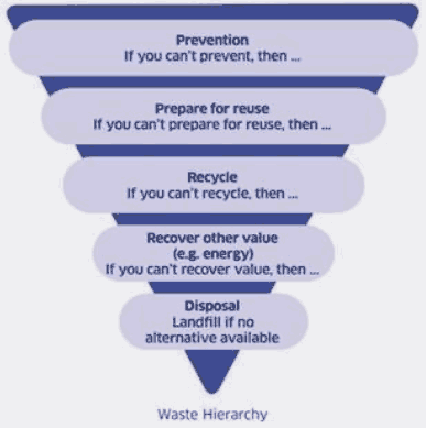
Circular economy
A circular economy is one that is designed to reduce the demand for raw material in products; to encourage reuse, repair and manufacture by designing products and materials to last as long as possible in line with the waste hierarchy.
Climate change adaptation
Climate change adaptation is about responding to the changes that we have seen in our climate over the last few decades, and preparing for the challenges that we will face as our climate continues to change.
Climate change mitigation
Climate change mitigation refers to efforts to reduce or prevent emissions of greenhouse gasses, which have a direct impact on global average temperatures, and reducing the current concentration of carbon dioxide by enhancing carbon sinks (for example, increasing the area of forest).
Commercial centre
Centres which have a more specific focus on retailing and/or leisure uses, such as shopping centres, commercial leisure developments, mixed retail and leisure developments, retail parks and factory outlet centres.
Community
A body of people. A community can be based on location (for example people who live or work in or use an area) common identity (for example a shared ethnicity, language, age) or common interest (for example the business community, amenity, sports, social or heritage groups).
Community facilities
Buildings or services used by the community, including community halls, recreation centres and libraries.
Community hub
A community hub is a multi-purpose centre, such as a community centre, medical centre or school, that provides a range of high quality and cost effective services to the local community.
Community wealth building
A people-centred approach to local economic development, which redirects wealth back into the local economy, and places control and benefits into the hands of local people.
Conservation area
Conservation areas are areas which have special architectural or historic interest that are considered worthy of protection. Their selection, assessment and designation is carried out by the planning authority. To be designated as a conservation area it must meet the criteria of ‘special architectural or historic interest the character or appearance of which is desirable to preserve or enhance’, as set out in Section 61 of the Planning Listed Buildings and Conservation Areas (Scotland) Act 1997.
Cultural significance
Cultural significance means aesthetic, historic, scientific or social value for past, present or future generations. Cultural significance can be embodied in a place itself, its fabric, setting, use, associations, meanings, records, related places and related objects.
Cumulative impact
Impact in combination with other development. That includes existing developments as appropriate, those which have permission, and valid applications which have not been determined. The weight attached to undetermined applications should reflect their position in the application process.
Cumulative impacts (in the context of the strategic transport network)
The effect on the operational performance of transport networks of a number of developments in combination, recognising that the effects of a group of sites, or development over an area may need different mitigation when considered together than when considered individually.
Custom-build housing
Where a person tasks a house builder to tailor a home to their preferences before it is built.
Decarbonisation
Reducing the amount of gaseous carbon compounds released by buildings, activities or operations.
Deliverable housing land pipeline
The expected sequencing of the Local Housing Land Requirement over the short (1-3 years), medium (4-6 years) and long-term (7-10 years), set out in the local development plan delivery programme.
Deliverable land
Land that is free from constraints or there is a commitment to overcome constraints, and development is able to be delivered in the period identified for the site within the Deliverable Housing Land Pipeline.
Derelict land
Previously developed land which is un-remediated and/or which has a constraint caused by its previous use which hampers its redevelopment or naturalisation.
Design flood
Magnitude of the flood adopted for the design of a site, usually defined in relation to the severity of the flood in terms of its return period.
Ecosystem services
The benefits people obtain from ecosystems.
Egress (safe, flood free pedestrian access and egress)
A route for the movement of people (not vehicles) of all abilities (on foot or with mobility assistance) between the development and a place of safety outwith the design flood level.
Enabling development
Enabling development is development that would otherwise be unacceptable in planning terms, but is essential, to secure the future of an historic environment asset or place which is at risk of serious deterioration or loss.
Essential infrastructure
Essential infrastructure includes digital communications infrastructure; telecommunications infrastructure; all forms of renewable, low-carbon and zero emission technologies for electricity generation and distribution and transmission electricity grid networks and primary sub stations; water and waste water infrastructure; and transport proposals and travel networks identified in the local development plan.
Evidence report
A supporting document to the local development plan. An evidence report summarises the evidence base for those proposals and policies set out in the development plan and demonstrates that appropriate consultation has been undertaken and regard given to the views of the community.
Facilities for managing secondary materials
Facilities where materials can be collected and sorted into the various component parts or consolidated into bulk quantities for re-use either in their original or an alternative function and for recovery.
‘Recovery’ means any operation the principal result of which is waste serving a useful purpose by replacing other materials which would otherwise have been used to fulfil a particular function, or waste being prepared to fulfil that function, in the plant or in the wider economy.
‘material recovery’ means any recovery operation, other than energy recovery and the reprocessing into materials that are to be used as fuels or other means to generate energy. It includes, inter alia, preparing for re-use, recycling and backfilling; ‘preparing for re-use’ means checking, cleaning or repairing recovery operations, by which products or components of products that have become waste are prepared so that they can be re-used without any other pre-processing.
Flood
The temporary covering by water from any source of land not normally covered by water, but not including the overflow of a sewage system.
Flooding from all sources
Includes:
Watercourse /Fluvial Flooding – caused by excessive rainfall or snow melt within a limited period, which overwhelms the capacity of the watercourse or river channel, particularly when the ground is already saturated. It can also arise as a result of the blockage of a channel and/or associated structures such as small bridges and culverts;
Pluvial Flooding – occurs when rainwater ponds or flows over the ground (overland flow) before it enters a natural or man-made drainage systems (e.g. a river or sewer/drain). It can also occur when drainage systems are at full capacity. It is often combined with sewer flooding and groundwater flooding;
Sewer Flooding – occurs when the sewerage infrastructure has to deal with loads beyond its design capacity. This occurs most often as a result of high intensity rainfall events;
Groundwater Flooding – occurs when the water table rises above ground level. In Scotland this is most commonly associated with the movement of water through sands and gravels, often connected to the rise and fall of river levels; and
Coastal Flooding – occurs as a result of high tide, storm surge and wave activity raising the level of the sea above adjoining land.
Flood risk
The combination of the probability of a flood and the potential adverse consequences associated with a flood, for human health, the environment, cultural heritage and economic activity.
Flood risk area or at risk of flooding
For planning purposes, at risk of flooding or in a flood risk area means land or built form with an annual probability of being flooded of greater than 0.5% which must include an appropriate allowance for future climate change.
This risk of flooding is indicated on SEPA’s future flood maps or may need to be assessed in a flood risk assessment. An appropriate allowance for climate change should be taken from the latest available guidance and evidence available for application in Scotland. The calculated risk of flooding can take account of any existing, formal flood protection schemes in determining the risk to the site.
Where the risk of flooding is less than this threshold, areas will not be considered ‘at risk of flooding’ for planning purposes, but this does not mean there is no risk at all, just that the risk is sufficiently low to be acceptable for the purpose of planning. This includes areas where the risk of flooding is reduced below this threshold due to a formal flood protection scheme.
Forestry and woodland strategy
A strategy prepared by a planning authority either singly or in collaboration with other planning authorities, which sets out policies and proposals for the development of forestry and woodlands in their area, according to [section A159] of the Town and Country Planning (Scotland) Act 1997.
Freeboard
Freeboard is the difference between the design flood level and either the finished floor levels, solum level, or deck level of a specific development. It is a safety margin designed to allow for the uncertainties involved in flood estimation and physical factors that cannot be assessed and vary between sites e.g., post construction settlement and wave action. In many cases an adequate freeboard allowance is 600mm above the design flood level[2] (in some situations a more detailed assessment of appropriate freeboard will need to be carried out).
Gardens and designed landscapes
The Inventory of Gardens and Designed Landscapes recognises sites where garden grounds and landscapes have been intentionally laid out for artistic effect which are of national importance. Their selection, assessment and designation is carried out by Historic Environment Scotland. Designed landscapes are managed primarily through the planning process by the appropriate planning authority.
Green infrastructure
Features or spaces within the natural and built environments that provide a range of ecosystem services.
Green networks
Connected areas of green infrastructure and open space, that together form an integrated and multi-functional network.
Green recovery
An economic recovery that helps us work toward net zero emissions in a way that is fair and that maximises the opportunities to deliver a thriving, sustainable economy.
Green space
Space, other than agricultural land, which serves a recreational or an amenity function for the public, or provides aesthetic value to the public such as areas of—
(a) grass,
(b) trees,
(c) other vegetation,
(d) water.
Historic battlefields
The Inventory of Historic Battlefields recognises sites where a nationally important battle took place, soldiers fought and died, and where significant military activities happened. Their selection, assessment and designation is carried out by Historic Environment Scotland. Battlefields are managed primarily through the planning process by the appropriate planning authority.
Historic environment
The historic environment is ‘the physical evidence for human activity that connects people with place, linked with the associations we can see, feel and understand’.
Historic environment asset
An asset (or ‘historic asset’ or ‘heritage asset’) is a physical element of the historic environment – a building, monument, site, place, area or landscape identified as having cultural significance.
Historic marine protected areas
Historic Marine Protected Areas are areas designated in Scottish territorial waters (0-12 miles) under the Marine (Scotland) Act 2010 for the purpose of preserving marine assets of national importance. These can be wrecks of boats or aircraft or more scattered remains, such as groups of artefacts on the seabed from a submerged prehistoric landscape. Their designation is carried out by Marine Scotland based on advice from Historic Environment Scotland.
Huts
A simple building used intermittently as recreational accommodation (i.e. not a principal residence); having an internal floor area of no more than 30 square meters ; constructed from low impact materials; generally not connected to mains water, electricity or sewerage; and built in such a way that it is removable with little or no trace at the end of its life. Huts may be built singly or in groups.
Infrastructure first
Putting infrastructure considerations at the heart of placemaking. For the purpose of applying the Infrastructure First policy, the following meaning of infrastructure will apply:
- communications – including digital and telecommunications networks and connections;
- existing and planned transport infrastructure and services;
- water management – supply, drainage systems and sewerage (including flood risk management);
- energy supplies/energy generation – including electricity and heat networks, distribution and transmission electricity grid networks, and gas supplies;
- health and social care services – including both services provided in the community directly by Health Boards and services provided on their behalf by contractors such as GPs, dentists and pharmacists;
- education – including early years, primary, secondary, further and higher education services;
- green and blue infrastructure; and
- spaces for play and recreation.
Infrastructure investment hierarchy
Scottish Government-wide common hierarchy to aid planning and decision-making, which prioritises enhancing and maintaining our assets over new build. See Infrastructure Investment Plan for Scotland 2021-22 to 2025-26 for further details. To support the Infrastructure Investment Plan and its Infrastructure Investment Hierarchy, also see ‘A guide to Property Asset Strategy in the Scottish Public Sector’
Just transition
Ending our contribution to climate change in a way that is fair and leaves no one behind
Landbank (construction aggregates)
A landbank is calculated by a Planning Authority and is a means of gauging whether there is sufficient consented construction aggregates (sand/gravel and hard rock) within their relevant market area, to avoid possible disruption and/or delays to supply. The calculation is primarily based on annual extraction figures, sales trends and the known reserves within existing consented sites.
Lifeline links
A lifeline ferry service required in order for a community to be viable.
Listed building
A listed building is a built structure of ‘special architectural or historic interest’. The term ‘building’ can be defined as ‘anything made by people’ such as houses, schools, factories, boundary walls, bridges and sculptures. Listing covers the whole of a building or structure including its exterior, interior and any ancillary structures within its curtilage (provided these were constructed before 1 July 1948). Their selection, assessment and designation is carried out by Historic Environment Scotland under the Planning (Listed Buildings and Conservation Areas) (Scotland) Act 1997. Listed Buildings are managed primarily through the Listed Building Consent process by the appropriate planning authority.
Local authority supported affordable housing plan
Plans or strategies for housing approved by a local authority e.g. Local Housing Strategy, Strategic Housing Investment Plan or future versions of such documents.
Local housing land requirement
The amount of land required for housing, as identified by the local development plan. The Local Housing Land Requirement (LHLR) is expected to exceed the 10 year Minimum All-Tenure Housing Land Requirement (MATHLR) set out in the National Planning Framework.
Local housing strategy
Local Housing Strategies were introduced as part of the Housing (Scotland) Act 2001 to widen the strategic and enabling role for local authorities in relation to housing in their area. The Local Housing Strategy (LHS) sets out the outcomes the Council and its partners want to achieve, and the actions they will take, to address housing need and demand in their area
Local outcomes improvement plan
A local outcomes improvement plan (LOIP) is produced by a community planning partnership (CPP), and describes its local priorities, what improvements the CPP plans for its local communities, and when it will make these improvements. The LOIP covers the whole of the council area that the CPP is responsible for.
Locality plan
A locality plan is produced by a CPP, and describes its local priorities, what improvements the CPP plans for its local communities, and when it will make these improvements. A locality plan covers a smaller area within a whole CPP area, or may also be produced for groups who share common interests or features, for example, young people leaving care or vulnerable adults.
Locations of concern
A location of concern has been defined as a specific, usually public, site that is used as a location for suicide and which provides either means or opportunity for suicide.
Masterplan
A strategic scheme within which a location is proposed to be regenerated or changed in order to meet a perceived challenge or strategic need.
Masterplan consent area
A masterplan consent area scheme can grant authorisation for the type of development set out in the scheme, within the geographic location (area) to which the scheme relates. In setting out the type of development that the scheme authorises, this can be either expressly specified or described as type of development that is specified in the scheme.
Minimum all-tenure housing land requirement
There is a statutory requirement for the National Planning Framework to contain targets for the use of land in different areas of Scotland for housing. To meet this, the National Planning Framework includes a Minimum All-Tenure Housing Land Requirement (MATHLR) for each planning authority in Scotland. The MATHLR is the minimum amount of land, by reference to the number of housing units, that is to be provided by each planning authority in Scotland for a 10 year period, as set out in Annex E. The MATHLR is expected to be exceeded in the local development plans Local Housing Land Requirement.
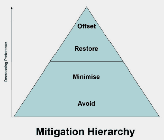
Mitigation hierarchy
The mitigation hierarchy indicates the order in which the impacts of development should be considered and addressed. These are:
i. Avoid – by removing the impact at the outset
ii. Minimise – by reducing the impact
iii. Restore – by repairing damaged habitats
iv. Offset – by compensating for the residual impact that remains, with preference to on-site over off-site measures.
National transport strategy 2
The National Transport Strategy sets out an ambitious vision for Scotland’s transport system for the next 20 years. The vision is underpinned by four priorities: Reduces Inequalities, Takes Climate Action, Helps Deliver Inclusive Economic Growth and Improves our Health and Wellbeing, each with three associated outcomes.
The Strategy sets out the strategic framework within which future decisions on investment will be made, including the sustainable travel and investment hierarchies.
Nature-based solutions
Nature-based solutions are actions to protect, sustainably manage, and restore natural and modified ecosystems that address societal challenges effectively and adaptively, simultaneously providing human wellbeing and biodiversity benefits.
Nature network
A Nature Network is a joined-up system of places important for wild plants and animals, on land and in water. It allows plants, animals, seeds, nutrients and water to move from place to place and enables the natural world to adapt to change, providing plants and animals with places to live, feed and breed. Effectively functioning nature networks will connect existing nature rich areas through habitat corridors, habitat ‘stepping stones’, or habitat restoration areas.
Scotland’s Nature Networks will enable opportunities for achieving ecological connectivity that meet local priorities for biodiversity and nature; whilst building and strengthening an evolving regional and national connectivity. Opportunities for implementation may be identified through, e.g. LDPs and/or Local Biodiversity Action Plans and/or other existing or new mechanisms such as those developed under the Scottish Biodiversity Strategy Delivery Plan, to achieve connectivity within and across urban, peri-urban and rural landscapes.
Negative emissions technologies
Negative Emissions Technologies (NETs) are an emerging field of technologies that remove greenhouse gases from the atmosphere and utilising carbon capture and storage sequester them permanently.
NETs can include forms of Direct Air Capture with Carbon Storage (DACCS), Bioenergy with Carbon Capture and Storage (BECCS) or other more experimental means such as enhanced weathering or biochar.
NETs can be considered one form of Greenhouse Gas Removals (GGRs), which also includes natural sequestration methods such as afforestation. It can also be used interchangeably with Carbon Dioxide Removal technologies (CDR).
Net zero
Scotland has set a target to become ‘ Net Zero ‘ by 2045. This means the amount of greenhouse gas emissions we put into the atmosphere and the amount we are able to take out will add up to zero.
Open space
Space within and on the edge of settlements comprising green space or civic areas such as squares, market places and other paved or hard landscaped areas with a civic function
Open space strategy
An open space strategy is to set out a strategic framework of the planning authority’s policies and proposals as to the development, maintenance and use of green infrastructure in their district, including open spaces and green networks. It must contain; an audit of existing open space provision, an assessment of current and future requirements, and any other matter which the planning authority consider appropriate.
Outdoor sports facilities
Uses where sportscotland is a statutory consultee under the Town and Country Planning (Development Management Procedure) (Scotland) Regulations 2013, which establishes ‘outdoor sports facilities’ as land used as: (a) an outdoor playing field extending to not less than 0.2ha used for any sport played on a pitch; (b) an outdoor athletics track; (c) a golf course; (d) an outdoor tennis court, other than those within a private dwelling, hotel or other tourist accommodation; and (e) an outdoor bowling green.
Peatland
Defined by the presence of peat soil or peaty soil types. This means that “peat-forming” vegetation is growing and actively forming peat or it has been grown and formed peat at some point in the past.
Placemaking
Placemaking is the process of creating good quality places that promotes people’s health, happiness and wellbeing. It concerns the environment in which we live; the people that inhabit these spaces; and the quality of life that comes from the interaction of people and their surroundings. Placemaking is a collaborative approach involving the design and development of places over time, with people and communities central to the process.
Place principle
All those responsible for providing services and looking after assets in a place need to work and plan together, and with local communities, to improve the lives of people, support inclusive and sustainable economic growth and create more successful places.
Play sufficiency assessment
A play sufficiency assessment is the assessment of the sufficiency of play opportunities for children in their area, carried out by a planning authority under the duty as set out in Section 7(5) Part 16D(1) of Planning (Scotland) Act 2019. The assessment forms part of the evidence report for the preparation of the Local Development Plan.
Prime agricultural land & land of lesser quality that is culturally or locally important for primary use
Prime agricultural land is that identified as being Class 1, 2 or 3.1 in the land capability classification for agriculture developed by Macaulay Land Use Research Institute (now the James Hutton Institute).
However, for land of lesser quality that is culturally or locally important for primary use (i.e. for example food production, flood management, water catchment management and carbon storage), this value should be recognised in decision-making.
Priority peatland habitat
Peatland habitats can be divided into four broad classes (blanket bog, upland raised bog, lowland raised bog, and fen), depending on the types of plants that formed the peat. Priority peatland habitats are sub-sets of these broad habitats which have been recognised under the Scottish Biodiversity Framework as being important to protect for their conservation and biodiversity value.
Protected characteristics
The Equality Act defines the following as protected characteristics:
- age
- disability
- gender reassignment
- marriage and civil partnership
- pregnancy and maternity
- race
- religion or belief
- sex
- sexual orientation
Public benefits
Public benefits as defined by the current Scottish Government policy on woodland removal.
Ramsar sites
Wetlands designated under the Ramsar Convention on Wetlands of International Importance.
Remedial notice (forestry)
A Remedial Notice is a notice issued by Scottish Ministers if it appears to them that a person has failed or is failing to comply with a condition on felling permission, a felling direction (including any condition imposed on it), a restocking direction (including any condition imposed on it), or a registered notice to comply.
A Remedial Notice requires the person to take such steps or stop such activity as may be specified in the notice on order to comply with or otherwise give effect to the condition, direction or (as the case may be) registered notice to comply, and, to take steps or stop the activity within the period specified in the notice.
Restocking direction
A Restocking Direction is a notice issued by Scottish Ministers, in response to an unauthorised felling or a failure to comply with a continuing condition on a felling permission. A restocking direction requires an owner of the land on which the felled tree was located or the land to which the continuing condition relates, to stock the land in question.
Recycling facilities
Facilities for the purpose of recycling. Recycling means any recovery operation by which waste materials are reprocessed into products, materials or substances whether for the original or other purposes. It includes the reprocessing of organic material but does not include energy recovery and the reprocessing into materials that are to be used as fuels or for backfilling operations. It does not include nuclear reprocessing.
Self-build housing
Where a person builds their own house or appoints their own builder.
Self-provided housing
Includes self-build housing, custom-build housing and collective build housing.
Setting
Setting is more than the immediate surroundings of a site or building, and may be related to the function or use of a place, or how it was intended to fit into the landscape or townscape, the view from it or how it is seen from areas round about, or areas that are important to the protection of the place, site or building.
‘Setting’ is the way the surroundings of a historic asset or place contribute to how it is understood, appreciated and experienced.
Scheduled monument
Scheduled monuments are archaeological sites or monuments of national importance that are legally protected under the Ancient Monuments and Archaeological Areas Act 1979. Their selection, assessment and designation is carried out by Historic Environment Scotland who maintains the schedule. Works to Scheduled Monuments are regulated by Historic Environment Scotland through their Scheduled Monument Consent process.
Short term let
The use of a dwellinghouse (a residential house or flat) for rental by persons other than the owner for short periods and for financial or other remuneration.
Typically includes properties advertised as being available for holiday let, although can apply to other situations.
Strategic transport network
Includes the trunk road and rail networks. Its primary purpose is to provide the safe and efficient movement of strategic long distance traffic between major centres, although in rural areas it also performs important local functions.
Sustainable development
Development that meets the needs of the present without compromising the ability of future generations to meet their own needs. (The Brundtland Definition. Our Common Future, The World Commission on Environment and Development, 1987).
Sustainable investment hierarchy
The National Transport Strategy 2 Sustainable Investment Hierarchy will be used to inform future investment decisions and ensure transport options that focus on reducing inequalities and the need to travel unsustainably are prioritised. We also need to focus on maintaining and safely operating existing assets, taking due consideration of the need to adapt to the impacts of climate change. Investment promoting a range of measures, including innovative solutions, to make better use of existing capacity will then be considered, ensuring that existing transport networks and systems are fully optimised. Only following these steps should investment involving targeted infrastructure improvements be considered.
Sustainable tourism
Sustainable tourism is defined by the United Nation World Tourism Organisation as “tourism that takes full account of its current and future economic, social and environmental impacts, addressing the needs of visitors, the industry, the environment and host communities.”
Sustainable travel
Sustainable travel includes travel by the top three modes in the sustainable travel hierarchy. It is recognised that in some locations, particularly in rural areas, where the top three modes have been judged as unfeasible for day to day travel, low emissions vehicles and shared transport options will play an important role.
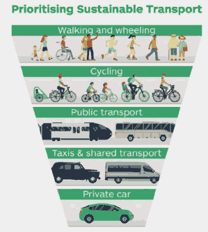
Sustainable travel hierarchy
The National Transport Strategy 2 Sustainable Travel Hierarchy should be used in decision making by promoting walking, wheeling, cycling, public transport and shared transport options in preference to single occupancy private car use for the movement of people. The efficient and sustainable freight transport for the movement of goods, particularly the shift from road to rail should also be promoted.
Town centre
Centres which display:
- a diverse mix of uses, including shopping;
- a high level of accessibility;
- qualities of character and identity which create a sense of place and further the well-being of communities;
- wider economic and social activity during the day and in the evening; and
- integration with residential areas.
Town centre first
The Town Centre First Principle asks that government, local authorities, the wider public sector, businesses and communities put the health of town centres at the heart of decision making. It seeks to deliver the best local outcomes, align policies and target available resources to prioritise town centre sites, encouraging vibrancy, equality and diversity.
Town centre vision
Towns and town centres are for the wellbeing of people, the planet and the economy. Towns are for everyone and everyone has a role to play in making their own town and town centre successful.
Transport appraisal
A Transport Appraisal should inform the spatial strategy by appraising the impact of the potential spatial strategy options on the transport network, in line with Transport Scotland’s Development Planning and Management Transport Appraisal Guidance. It should determine the potential impacts of development on the transport network and mitigation to address adverse impacts, how they will be funded and who should deliver these. This should inform the Proposed Plan.
Transport assessment
A Transport Assessment report should aim to provide supporting evidence to accompany the planning application to demonstrate that the development is sited in a location where current and likely future travel behaviour will produce a desired and predicted transport output. The Transport Assessment should provide information in a suitable form to enable the local authority and, if necessary, Transport Scotland to assess and determine the planning application, seek any changes to the proposal and devise necessary planning conditions or negotiate planning or other legal agreements.
Travel plan
A Travel Plan (TP) is a document that sets out a package of positive and complementary measures for the overall delivery of more sustainable travel patterns for a specific development. Their ability and success in influencing travel patterns is dependent upon the commitment of the developer or occupier of a development and the enforcement of travel plan monitoring by the local authority. Travel plans should be implemented to encourage a shift in transport mode for those travelling to and from a development.
Unused or under-used land
An area of land that is stalled awaiting development, or a pocket of land within neighbourhood that is not developed or cannot be developed for other meaningful use or does not have particular identified long-term use.
Vacant land
Previously developed land, without physical constraint, which the Planning Authority has indicated is currently available for redevelopment.
Veteran tree
A veteran tree can be classified as such due to age (including relative age for its species) or for its biological, aesthetic, or cultural interest. Veteran trees are usually mature and provide additional habitat from natural damage, environmental conditions or management (e.g. coppice, decay hollows, fungal fruiting bodies, cavities).
Water compatible uses
Comprise:
- flood control infrastructure
- environmental monitoring stations
- water transmission infrastructure and pumping stations
- sewage transmission infrastructure and pumping stations
- sand and gravel workings
- docks, marinas and wharves
- navigation facilities
- Ministry of Defence (MOD) defence installations
- ship building, repairing, and dismantling
- dockside fish processing and refrigeration and compatible activities requiring a waterside location
- water-based recreation (excluding sleeping accommodation)
- lifeguard and coastguard stations
- amenity open space
- nature conservation and biodiversity
- outdoor sports and recreation and essential facilities such as changing rooms
- essential ancillary sleeping or residential accommodation for staff required by uses in this category, subject to a specific operational warning and evacuation plan.
Wellbeing economy
Building an economy that is inclusive and that promotes sustainability, prosperity and resilience, where businesses can thrive and innovate, and that supports all of our communities across Scotland to access opportunities that deliver local growth and wellbeing.
Wheeling
Travelling by wheelchair.
Woodland
Land under stands of trees with a canopy cover of at least 20%, or having the potential to achieve this, including integral open space, and including felled areas that are awaiting restocking (replanting). The minimum area is 0.1 ha and there is no minimum height.
World heritage sites
World Heritage Sites are internationally important cultural and/or natural heritage sites which have been inscribed for their “Outstanding Universal Value”. Though no additional statutory controls result from world heritage designation, the impact of proposed development upon the outstanding universal value, including its authenticity and integrity of a World Heritage Site and its setting, is a material consideration in determining planning applications. Their assessment and designation is carried out by United Nations Educational, Scientific and Cultural Organisation (UNESCO) based on advice from State Parties and the relevant devolved Government.
Contact
Email: Chief.Planner@gov.scot