Assessing fisheries displacement by other licensed marine activities: good practice guidance - literature review
This project developed ‘Good Practice Guidance for Assessing Fisheries Displacement’ through a detailed literature review and consultation with the ScotMER Fish and Fisheries Receptor Group (FFSRG), commercial fisheries industry, offshore energy and regulatory sectors.
7 Literature Review
7.1 Commercial fishing activities and operating practices in Scotland
According to an economic analysis performed by Marine Scotland (2020b) in 2018, Scotland's commercial fishing industry generated 0.2% of the overall Scottish Economy Gross Value Added, with over 4,500 people employed within the fishing industry.
Commercial fishing activity is temporally and spatially variable, depending on several factors which include the following:
- The distribution and abundance of commercially exploited fish and shellfish species;
- The Total Allowance Catch (TAC) and quotas which are allocated to each fishery[8];
- Licensing for certain species such as a shellfish entitlement or salmon fishing license;
- Seasonal and/or spatial restrictions on fishing activity, fishing methods, gear specifications and vessel sizes; and
- Environmental conditions such as weather.
The landings by Scottish vessels account for a large proportion of the overall value of landings in the UK (60% of all landings by UK vessels in 2019) (Marine Scotland, 2020b). In Scotland, pelagic species which are mostly targeted by trawlers in the mid-water column comprise the greatest proportion of landings weights (~60%). Demersal trawling and shellfish fisheries comprise approximately 24% and 16% of landings weights respectively. Shellfish landings includes those from static gears, Nephrops trawlers and scallop dredgers. Demersal, pelagic and shellfish fisheries each comprise around 1/3rd of the landings values from Scotland (Marine Scotland, 2020c).
In relation to commercial fisheries displacement, based on the priority research areas which have been identified by the ScotMER FFSRG and the consultation which has been carried out to date by Marine Scotland, the fishing methods which have been highlighted as the priority focus on within this report are demersal trawling (including pair trawling and Nephrops trawling), scallop dredging, seine netting and creeling.
A description of these fishing methods is provided in Sections 7.1.1 to 7.1.4, which has been primarily informed by Seafish (2015, 2021[9]), commercial fisheries technical reports and consultation with fisheries stakeholders.
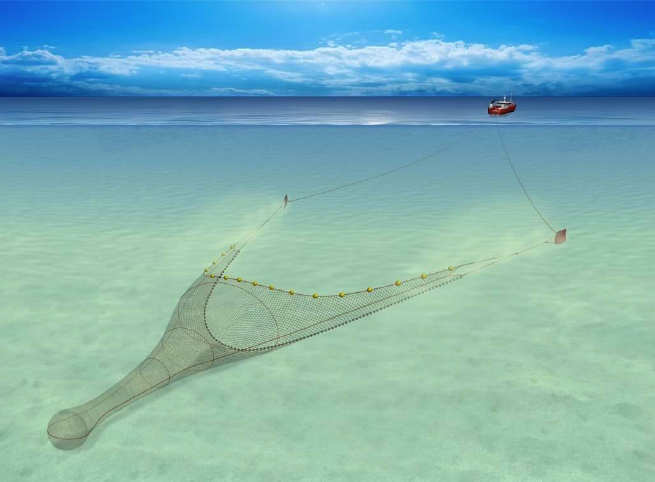
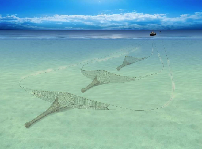
7.1.1 Demersal trawling
Demersal trawlers operate one or more (twin rigs) funnel-shaped nets which are towed over the seabed to catch demersal fish and shellfish species. The net is held open laterally by trawl doors on either side (otter boards) and vertically by floats attached to the headline of the net. Where the net is in contact with the seabed (groundline), the materials used often depend on the ground conditions and target species. Demersal trawlers working over uneven, rocky grounds may use rockhopper gear, where bobbins (rubber discs) are attached to the groundline. Demersal trawlers which work over soft sandy and muddy substrate (such as Nephrops trawlers) may use lighter materials in the groundline, due to the need to disturb seabed dwelling species in these habitats. Demersal trawl vessels can reconfigure their gear to target different species, depending on season and stock for example Nephrops to squid. Demersal trawlers typically steam at between 2.5 to 3.5-4 knots when operating the trawl net (Seagreen, 2017; Seafish, 2021).
Demersal trawls are operated by vessels of a range in size, under 10 m to well over 15 m in length. The distance between the trawl doors typically ranges from 50 to 200 m and the length of the net (from trawl door to end of net) can be up to 200 m (SFF, 2020). The manoeuvrability of smaller vessels is higher than that of larger vessels, and as the gear is likely to be lighter for smaller vessels the seabed penetration depth may be less. In general, demersal trawls are operated to minimise seabed penetration in order to protect the fishing gear and avoid gear fastenings (Seafish, 2021).
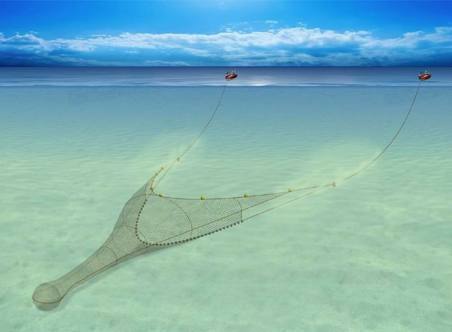
7.1.1.1 Pair Trawling
Demersal pair trawling involves two boats towing a single net. The net is similar to that of a single trawl, however, rather than using trawl doors, the net opening is maintained by the distance between the two vessels, which is usually
300 – 600 m (SFF, 2020; Seafish, 2015; 2021). The distance between the vessel and the start of the net is typically 1.5 km (SFF, 2020). In comparison to single-rig trawls, pair trawling enables a larger net to be operated while reducing drag of the gear. By way of the method of operating pair trawls, the overall required area is greater and manoeuvrability, once the net is deployed is lower than that of single-rig trawls.
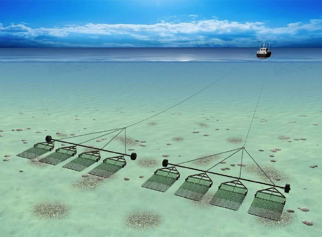
7.1.2 Scallop dredging
Scallop dredging vessels operate a rigid metal frame onto which is attached a chain mail bag and at the mouth a series of spring-loaded teeth which penetrate the seabed, dredging the scallops which are mostly sedentary and are seabed dependent. The dredges are attached to a spreading bar which is often attached to one of two beams, on either side of the fishing vessel. Each scallop dredge is approximately 0.75 m wide and the number of dredges which are operated can vary from 3-4 on a small vessel to up to 20 dredges. In Scotland there are specific regulations about the maximum number of dredges which can be operated within specific parts of the territorial sea (The Regulation of Scallop Fishing (Scotland) Order 2017: 8 dredges per side between 0 – 6 NM and 10 dredges per side between 6 and 12 NM). Scallop dredging activity is often carried out by very large nomadic vessels, which show episodic intensive periods of activity for approximately 2 years and then move to another area. The grounds are usually left for around 5-7 years before dredgers return and repeat the cycle (Seagreen, 2017). The typical penetration depths for scallop dredges is between 2-6 cm, based on a single tow (Currie & Parry, 1996; Løkkeborg, 2005, as cited in Catherall & Kaiser, 2014). Over time, dredges may penetrate deeper into the seabed if there is a high potential for repeat activity.
7.1.3 Scottish seine netting
Seine netting includes beach seine, Danish seine and Scottish seine netting. The main seine netting fishing method operated in Scotland is Scottish seine netting and this was historically the primary demersal fishing method in Scotland. Many seine netting vessels converted to operate demersal trawls, although seine netting is still in operation, mainly in North and North East Scotland and Shetland. Despite this, there has been a resurgence of this fishing method in recent years, with boats being purpose-built for seine netting (Seafish, 2015).
Scottish seining is typically operated over soft sediments, as the gear can become damaged when operated on harder substrates (Seafish, 2021). This fishing method involves shooting a net in a circular motion, with the net being at the mid-point of this circle, with ropes either side which are attached to the vessel. The ropes on either side of the net pull the net closed as the vessel tows the gear, herding demersal fish into the net. The net is then hauled by the vessel via a winch. The rope on either side of the net can be 1.7 to 3 km long and the area of seabed encircled by the net ranges from 600 to 1000 m diameter (Seafish, 2021).
7.1.4 Creeling
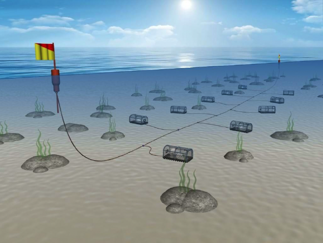
Creeling (pots, traps) for crab and lobster occurs throughout UK waters although the design of creels may vary depending on region and target species. Typically, all creels have one or more "funnel" shaped entrances for the shellfish to enter and are assembled in fleets of between 10 and 50 creels per fleet (in a string). Larger static fishing vessels will have greater capacity to operate longer strings of creels over large areas of ground, with the strings of creels varying from 100 to 500 m in length. Once deployed the strings are anchored at each end. Full-time creelers will often attempt to turn over (haul, empty and reset) their creels every 12-24 hours to maximise catch (weather-dependent). Larger vessels with a greater number of creels may require longer periods of time to haul, empty and reset their gear (up to three days). Creels by law, should be marked with flagged dhans (marker flags), buoys or cans. Vessels engaging in creeling are generally under 10 m in length, with crew members typically varying from one to three.
7.2 Licensed marine activities
There are various licensed marine activities which may overlap spatially within the marine environment with the fishing industry. The way in which an offshore development's activity or infrastructure influences commercial fishing or displacement can depend on the structures which are installed, the methods which are used for installation and maintenance and the mitigation measures which are implemented.
A description of licensed marine activities which are understood to be most relevant to fisheries displacement are described in Sections 7.2.1 and 7.2.2.
7.2.1 Marine Renewable Energy (MRE) projects
MRE developments mainly comprise equipment and associated infrastructure to harness offshore wind, wave and tidal energy. MRE projects range from a single device to an array of devices across a wider development area. The design, layout, installation and maintenance of a MRE development varies depending on the conditions and the environmental constraints.
7.2.1.1 Offshore wind
The technology which is available to offshore wind developers has advanced rapidly in the last 10-15 years in terms of the design and size of offshore turbines, the materials and protection types for cables and in the methods of installation and maintenance. These advancements allow for a more efficient energy generation process with lower consumer and operator costs using the same resource quality and enabling access to a larger number of options for locations of varying conditions (IRENA, 2019).
Offshore wind turbines are comprised of above sea surface and subsurface components. The above surface turbine infrastructure is composed of several (usually 3) rotating blades (rotors) which are connected to a central hub which comprises multiple interacting parts including the generator which converts mechanical energy to electricity. This electricity is passed to the turbine tower. The tower is then connected to the subsurface portion of the turbine, known as the foundation. The foundation can either be fixed to the seabed or floating within the water column (Offshore Renewable Energy (ORE) Catapult, 2019). The foundation can either be fixed to the seabed or floating within the water column (ORE Catapult, 2019).
7.2.1.1.1 Fixed wind turbine generators
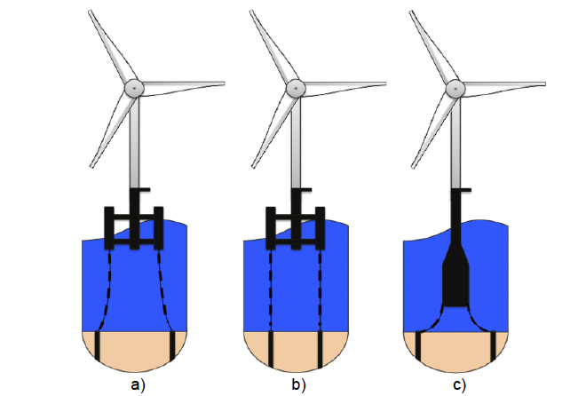
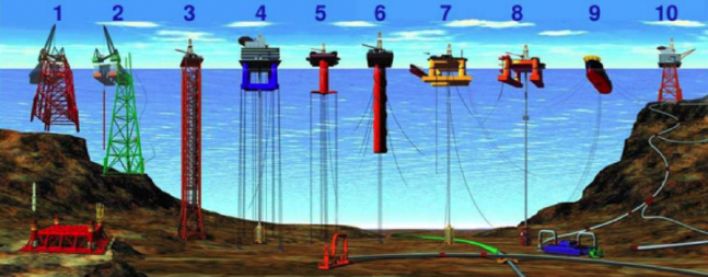
Fixed turbines have foundations which are fixed to the seabed and support the surface component of the turbine. These devices can be installed in nearshore or offshore environments with different installation techniques and foundation structures depending on the project design and the local site conditions. Examples of fixed bottom foundations include monopiles, gravity bases or jackets/tripods (Figure 7‑6) (ORE Catapult, 2019).
Typically in commercial fisheries impact assessments for Offshore Wind Farms (OWFs) with fixed foundations, it has often been assumed by the practitioner that access to fishing grounds would resume, potentially under the assumption of certain necessary changes to operation practices, the type of fishing gear they are operating and depending on the perception of safety of the skipper of the vessel (Ørsted Hornsea Project Four Ltd, 2020, Moray Offshore Windfarm (West) Ltd, 2017, Seagreen, 2018).

7.2.1.1.2 Floating turbines
In water depths of greater than 60m, the traditional fixed turbine design is generally not practical. In these waters, it is expected that floating turbines will be used. Floating turbines are buoyant and anchored to the seabed via mooring lines (ORE Catapult, 2019). Examples include semi-submersibles, tension leg platforms and spar buoys (Figure 7‑7) (Rixen, 2014).
The presence of mooring lines connecting the floating turbines and dynamic cables free-hanging in the water column reduces the likelihood of a resumption of access to fishing grounds following installation.
7.2.1.1.3 Tidal turbines
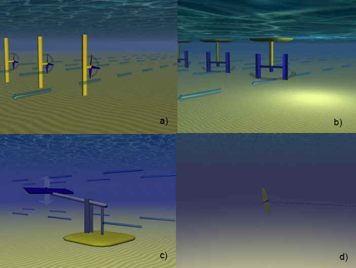
Tidal projects are predominantly composed of submerged devices anchored on or fixed to the seabed with structures which rotate or oscillate with the tidal stream (Aquaret, 2008a) (Figure 7‑8). Tidal devices may be fixed or tethered to the seabed via mooring lines (e.g. kite designs) and are primarily located within tidal streams in the nearshore environment, such as in the headlands around islands (e.g. Minesto, 2016).
There are four consented tidal arrays in Scotland to date. Two of these, MeyGen and Bluemull Sound are operational in the inner Sound of the Pentland Firth and between the Islands of Yell and Unst in Shetland, respectively (Scottish Government, 2020b).
7.2.1.1.4 Wave energy devices
Wave energy devices may contain above-surface, surface and/or subsurface components and may be fixed or tethered to the seabed via mooring lines or other methods. There are various design options for wave energy developments which can be located nearshore and offshore (Figure 7‑9). Wave energy technology currently remains a novel technology, with various prototype designs being tested (Aquaret, 2008b). There are currently no consented commercial wave arrays in Scotland (Scottish Government, 2020b).
7.2.1.2 Other renewable infrastructure
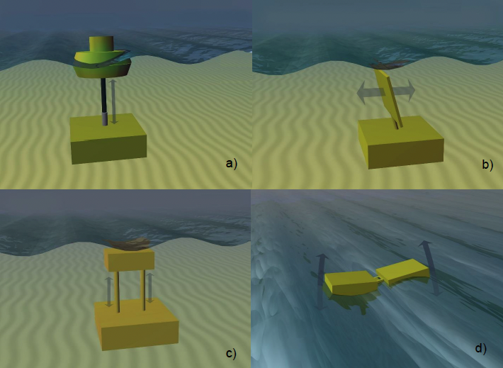
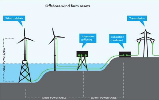
The energy generated from renewable energy developments is transported to the onshore electrical grid network via electrical transmission infrastructure (Figure 7‑10). Within a renewable development, this typically includes inter-array cables, which connect turbine devices to each another and to offshore substation(s). Offshore substations collect, transform and transfer energy from the turbines, and are composed of surface infrastructure (i.e. topsides) attached to the seabed via a foundation (e.g. jacket infrastructure). Export cable(s) then transmit the energy from the from the offshore substation to shore (ORE catapult, 2019). For renewable energy arrays which are located farther offshore and transmitting High Voltage Alternating Currents (HVAC), a 'booster' station may be construction at the mid-way point of the export cable, which is of a similar design to the offshore substation (Ørsted, 2020).
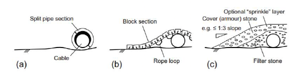
Inter-array and export cable infrastructure can be installed with different techniques and equipment. BERR (2008) provides a comprehensive review of different cable installation and protection techniques. In brief, cables may be laid and buried simultaneously (e.g. plough installation) or laid and buried sequentially (e.g. jet trencher). Target burial depths are estimated prior to construction through cable burial risk assessments (CBRAs) which consider local ground conditions, cable installation techniques and interactions with other sea users. If burial cannot be achieved, mechanical protection may be placed such as articulated half shells (tubular product), rock and concrete mattressing (Figure 7‑11).
7.2.2 Oil and gas and other developments
In the UK, oil and gas infrastructure is concentrated in the North Sea, offshore of the east coast of the UK. There are various types of infrastructure associated with the oil and gas industry, both surface (e.g. platforms and Floating Production Storage and Offloading (FPSOs) and subsurface (e.g. manifolds, pipelines, umbilicals, risers, and wellheads). Safety zones (which prohibit or advise, against the presence of other sea users such as fishing vessels) are typically in place around subsurface structures such as manifolds and wellheads, as well as surface infrastructure such as platforms and FPSOs (Health and Safety Executive, 2008).
Aggregate extraction is another industry which has the potential to lead to displacement of fishing effort. Aggregate extraction occurs in licenced areas in UK waters, concentrated in the south and south east of England. Aggregate dredging vessels operate within the licenced area to extract minerals and sands and gravels (The Crown Estate, 2021). The licensed areas are split into active dredge zones, which represent the area available to be dredged at any one time (British Marine Aggregate Producers Association, 2021). This is in the aim of reducing the spatial footprint of the dredging activity. Fishing effort may be displaced whilst a dredging vessel is operating within an active dredge zone.
Additional industries which might potentially lead to displacement of fishing vessels include aquaculture, Carbon Capture and Storage (CCS) and defence.
7.2.3 Marine protected areas with fisheries management measures
Fishing activity can be managed through plans, policies and restrictions related to MPAs and wider fisheries management (Scottish Government, 2021). Management measures for MPAs may include reducing or removing fishing pressure either permanently or seasonally throughout the MPA, or within defined zones (Marine Scotland 2014; ABPmer, 2017; JNCC et al., 2020). Fisheries management measures may also be in place outwith MPAs, to promote the sustainable harvest of fish stocks and the protection of the marine environment. These measures include but are not limited to setting catch limits through fish quotas (e.g. TACs), placing limits on time at sea, setting restrictions on fishing gear and equipment and applying spatial closures (Scottish Government, 2021).
Fisheries management measures may lead to displacement for one or all fishing methods operating within the areas in which the management measure applies (Marine Scotland, 2014; Scottish Government, 2020e; ABPmer, 2017). Displacement impacts occur in a similar manner as to those relating to other licenced marine activities, leading to reduced availability of grounds and increased competition and conflict, and is likely to be most severe where fishing activity is excluded as a result of spatial closures (Scottish Government, 2020e). Crucially, displacement from MPAs and fisheries management measures can further restrict the availability of grounds for fisheries, in addition to the other licenced activities described in Section 7.2.1 and 7.2.2.
7.3 Existing research and approaches
This section provides a summary of the existing research into the potential impact pathways relevant to commercial fisheries displacement. This section includes a brief summary of some of the existing studies on ecological impacts to commercial fisheries displacement, and then on commercial fisheries receptors themselves. The ecological impacts will not be of key focus within the Good Practice Guidance which will focus only on commercial fisheries impacts.
7.3.1 Ecological impacts of commercial fisheries displacement
With the exception of EIAs and consent applications, the majority of the methods for assessing displacement which were identified in the Literature Review focus on temporary or permanent closures associated with no take zones, limitations on fishing methods and gear specifications, or other fisheries management measures (Chollet et al., 2016; Slijkerman & Tamis, 2015; Greenstreet et al., 2009; Bastardie et al., 2015).
In many cases it is understood that the net environmental and ecological benefits of a protected area where fishing activity is restricted will improve the fish or shellfish stock and lead to a beneficial impact on commercial fisheries through increased availability and improved habitat condition for exploited species.
Kenchington et al., (2018) reviewed studies investigating the influence of no-take marine reserves on the marine environment, and also fisheries stakeholders. The review concludes that no-take marine reserves show a trend of an overall positive effect on parameters such as in increased stock, spill-over of adults and larvae and increased egg production. The conclusion of a benefit is usually limited to specifically monitored parameters, and the need to involve all stakeholders in the marine spatial planning of such spaces is highlighted.
Goñi et al., (2008) investigated the spillover impact of 6 MPAs in the Mediterranean. It was observed that displaced fishing effort was concentrated near fisheries closures due to the spillover effect of commercially exploited fish creating productive waters around the MPAs.
It is important to note that, assuming the fishing activity is not stopped entirely, the pressure of fishing effort would be redistributed and not reduced. The impact of this displaced fishing activity is difficult to predict due to the complex and variable patterns of fishing activity, especially within a new environment. Several modelling studies have indicated that displacement resulting from fisheries closures can have a detrimental effect on the marine environment on the area to which fishing is relocated, especially when an area which typically supports high levels of fishing effort is closed (as referenced in ABPmer, 2017). Feedback from stakeholders also indicated that closures may also result in increases in benthic species (e.g. starfish), some of which can adversely affect fish stocks.
The potential impacts of OWFs on the marine environment has also been investigated, although to a lesser extent when compared with no-take zones and fisheries management measures. Methratta and Dardick (2019) conducted meta-analysis to understand the potential impacts of OWFs on fish populations. The results indicated that fish abundance inside wind farms was generally greater compared to nearby reference sites. The MMO also conducted a review of post-consent monitoring for OWFs in English waters, which indicated that although some changes in the fish and shellfish environmental baseline were apparent, this was not attributed to the OWF, as similar differences were recorded in reference areas (MMO, 2014).
Roach et al., (2018) studied the impact of a short-term closure of lobster fishing grounds within the Westermost Rough OWF, associated with construction activities. The temporary closures lead to increased abundance and size of lobsters, with a short-term increase in catch rates following the re-opening of the fishery. Roach et al., (2018) suggest that these temporary closures could act as a management tool to protect spawning stocks and offset the economic loss of permanent closures.
Degraer et al., (2020) observed increased plaice catch rates and landings around operational wind farms when compared to the wider area. This trend was not observed for sole where the catch rates within and around operational wind farms remained similar to those of the wider area.
7.3.2 Current approaches for the assessment of commercial fisheries displacement
A comprehensive review of the available tools for assessing displacement is provided in ABPmer (2017). Several of these sources developed complex behavioural or economic models in order to predict where fishing is likely to be redistributed to, and the associated impacts of this displacement, in terms of the fishing fleet or the marine environment (e.g. benthic environment or fish stocks). However, due to the complexity in predicting fishing activity and the behavior of a skipper under variable sea conditions, these models require several assumptions to be made, and this limits their use as a robust tool for assessing displacement for other licensed marine activities (Campbell, 2015; MMO, 2014; ABPmer, 2017).
Alternative studies on the assessment of fishing displacement focused on assessing the availability of alternative grounds, using Vessel Monitoring System (VMS) data and spatial data on sediment types (Campbell et al., 2014; Marine Scotland, 2014). For example, when assessing the impact of various management options for 16 MPAs in Scotland, Marine Scotland (2014) assessed the potential availability of alternative grounds within 20 NM of the MPA, using VMS data, ScotMap data and information on sediment type (e.g. mud burrowed habitat for Nephrops grounds). This study also assessed whether the fishing grounds would be able to 'absorb' the effort that was likely to be displaced into these areas as a result of the management option, based on the availability of grounds within 20 NM and the amount of fishing effort being displaced. Overall, levels of fisheries displacement were considered to be low and this is partly due to the management and planning measures avoiding the most valuable fishing areas where possible (Marine Scotland, 2014). In 2020, the Scottish Government released a report which reviewed the socio-economic impact of the MPAs designated in 2016 using a quantitative and qualitative approach (Scottish Government, 2020e). The results indicated that since 2016, the landings by towed gear in non-MPA ICES rectangles had increased in comparison to ICES rectangles which contained MPAs, but that this trend was only observed for landings effort of > 10 hours and > 50 hours in an MPA. Landings of > 200 hours in MPAs, decreased across all ICES rectangles in 2016. It should be noted that this study also acknowledges that other factors will influenced landings aside from the MPA regulations. Stakeholder consultation carried out during this project indicated that fishermen were concerned about the potential increased conflict and competition for fishing grounds resulting from the displacement from the MPAs. Fishermen also indicated that fishing was displaced to areas on the edges of the MPA for smaller vessels, but potentially at more distant fishing grounds for larger vessels.
7.3.3 Fisheries displacement from MREs
There are few studies available which specifically investigate fisheries displacement in relation to MREs. These have been reviewed within the Literature Review carried out by Brown and May Marine (2021) to inform ScotMER evidence gap FF02, where more details are provided on each study (Marine Scotland, 2018).
Gray et al. (2016) analysed fishing activity data in areas within and relevant to 6 operational windfarms in the Irish Sea. The findings of this study showed an overall reduction of fishing effort by demersal trawling vessels, which was explained in part by changes in TAC allocations. Displacement of activity by Nephrops trawlers was observed in relation to Walney 2, whereas for all other operational OWFs in the study no significant displacement of this fishery was recorded. This study highlights a limitation in the assessment of displacement specifically in relation to a development, as fishing activity is influenced by many environmental and legislative factors, especially since the departure of the UK from the EU and Common Fishery Policy.
Campbell et al., (2015) analysed VMS data to predict the potential displacement effects of a wave MRE development and an MPA in South West England. Maps of gear-specific VMS were produced to understand the distribution of fishing activity and the spatial overlap with the MRE development and MPA. The results indicated that beam trawling and demersal trawling were widespread in the region, and that these fishing methods were present at low effort levels within the MRE development and MPA. On the contrary, some static gear fishing methods (longlining and gill netting) had a more localised distribution which overlapped with the MRE development and MPA. It was predicted that these fishing methods would be displaced into other areas, which could result in increased competition or conflict, especially with mobile-gear users.
De Groot et al. (2014) provide a stakeholder-based study of the coexistence of the fishing and MREs. The findings highlighted a need for more robust data to quantify displaced fishing activity, for robust methodologies for assessment and standardised consultation process which is agreed upon by MRE developers and fisheries stakeholders.
7.3.3.1 European studies of commercial fisheries displacement
A number of studies have also been carried out in European waters, where fishing is prohibited within operational windfarms by several member states. The potential health and safety issues of permitting fishing, and particularly demersal trawling to resume within an operational OWF in Europe has been highlighted in several studies (Primo Marine, 2019; Stelzenüller et al., 2020), which is of ongoing concern and focus in the UK, in particular in reference to overtrawlability and subsea cables, and uncertainties of the definition of sufficient spacing between two OWF turbines for a demersal trawler to fish, given any trawling vessel is subject to the specific operating practices and decisions of the skipper.
Degraer et al., (2020) studied fishing activity (effort, landings and catch rate) over an eleven-year period to investigate the impact of the offshore wind developments in Belgian waters. As fishing is prohibited within OWFs in Belgian waters, fishing activity stopped within the OWF area following installation. Fishing effort around the edges of OWFs slightly increased following construction, especially in the case of OWFs located further offshore. Landings of sole from waters around the edge of OWFs were not discernable from the wider region, however, landings of plaice from these waters were slightly higher.
Several EU studies are also available which discuss the potential for co-existence between commercial fisheries and the MRE industry to reduce the impact of spatial exclusion. These are provided in Brown and May Marine (2021), and inform ScotMER evidence gap FF14:
- In the Netherlands, Primo Marine (2019) concluded that the cost of energy would increase for operational wind farms if demersal fishing activity continued within the site, as a result of the health and safety risks, insurance claims as well as project design implications and costs for cable repairs. The study recommended that the cost should be weighed against the benefits of continued access for the fishery.
- Stelzenüller et al (2020) reviewed the potential for co-existence between MRE developments and commercial fisheries in Europe, including best practice and lessons learned and suggested potential solutions for co-existence between the two industries. The study predicts that spatial conflict will increase in the near future as MRE developments increase, and that the impacts will mostly occur to mobile fishing methods targeting demersal species and crustaceans. Best practice examples of co-existence, co-location and co-operation are provided, such as in Denmark, where fishing industries are consulted with in order to negotiate mitigation measures. Stelzenüller et al (2020) also list mitigation measures which could reduce conflict potential which include early communication and stakeholder consultation, and co-design approaches to reduce the impact potential on fisheries
- Dupont et al 2020 characterised the conflicts between OWFs and the fishing industry, such as health and safety risks and insurance claims, and reviewed their occurrence within the EU and how conflicts have been addressed. Potential solutions to mitigate against conflicts and improve co-existence were also provided in the study, such as stakeholder engagement and socio-economic impacts assessments (at a cumulative and project-specific level). This study also suggests the potential for designing fishing compatible MRE developments to reduce spatial exclusion in and around MRE developments. It was identified that the operation of static fisheries within an MRE development may be possible, but that seabed fisheries operating within a MRE development was unlikely, especially for seine netting and pair trawling. The study suggests wider corridors within MRE developments could improve co-existence with commercial fisheries and reduce the potential for long-term exclusion impacts.
Key actions which may encourage coexistence of the fishing and MRE industries were consistently highlighted as stakeholder engagement, consideration of fishing activity in the design of OWF projects, and consideration of socio-economic impacts as part of the assessments (Dupont et al, 2020; Schupp et al, 2021).
7.3.4 EIA case studies
In order to understand the typical methodologies which have been used to assess displacement of fishing activity as a result of other licensed marine activities, a number of EIAs which were submitted as part of consent applications for various types of offshore activities have been reviewed and are summarised within this section.
The review revealed that the methodology used to assess displacement within EIAs is not consistent. Importantly, fisheries displacement from other licensed marine activities differs from restrictions on fishing associated with MPAs, assuming that access to fishing grounds is expected to resume following construction of a development. Resumption of access to fishing grounds differs from the perceived ability to fish within a development area (such as an OWF) which depends on many factors including the compatibility of the fishing activities with the infrastructure and the level of risk perceived by the individual skipper (Brown and May Marine and Marine Scotland, 2021).
The differences in methodologies which are used is logical due to the to the spatial and temporal variation in the fishing activity, operating practices and fishing effort in the areas of the developments. In most case studies, displacement of commercial fishing activity has been assessed on the basis of the assessment of temporary or long-term loss / restricted access to fishing grounds. In some EIAs the two impact pathways of loss / restricted access to fishing grounds and displacement of fishing activity are assessed together.
Typically, during installation, a safety zone will be in place around active installation works/infrastructure or project vessels which are restricted in their ability to manoeuvre. In the case of mobile gears, this safety zone is often assumed to be the area of potential loss of access to grounds, with fishing vessels being required to adhere to COLREGs. For creelers, the area of potential loss/restricted access to fishing grounds is often assumed to temporarily be parts of or the whole development, in consideration that static fishing gear will often be requested to be relocated in order to carry out project construction activities. In this case, the relevant mitigation which is recommended is in line with FLOWW (2014, 2015). For operational projects, there may not be mandatory safety zones in place, and the assessment of displacement is based on the operational infrastructure characteristics and fishing activity in that area.
In the UK, as there are no legal closures of operational OWFs to fishing, the ability for fishing activity to resume is subject to a number of project and vessel specifications, as highlighted in Brown and May Marine (2021). These include the following:
- Minimum spacing and width of corridor clear of infrastructure between turbines;
- Windfarm design, layout and configuration;
- Foundation type (floating vs. fixed foundations);
- Approach to cable installation, burial, protection and monitoring;
- Fisheries liaison and communication strategy;
- Free-hanging dynamic cables in the water column (for floating offshore wind);
- Target species presence following construction;
- Vessel manoeuvrability, operating patterns, and gear type (active vs. passive) and dimensions; and
- Level of contact of the fishing gear with the seabed (i.e. seabed penetration depths).
Gray et al., (2016) also highlighted the following key deterrents for fishing within a wind farm:
- Health and safety risks, including snagging and risk of collision in the event of engine failure; and
- Financial risk due to risk of damage to fishing gear.
7.3.4.1 Good Practice Guidance - Offshore Wind Farm (OWF) EIAs: summary
As noted in Section 7.3.4, displacement of fishing effort/activity is often assessed within OWF EIAs as a function of the impact of loss or restricted access to traditional fishing grounds, as the latter may lead to displacement, assuming fishing activity is relocated and not stopped. In these assessments, the potential loss of access to fishing grounds is often considered to have the same or greater level of impact than the potential impacts of displacement, due to the primary focus of displacement and the most sensitive receptor (particularly during construction) being of static gear operators in EIAs to date.
The assessment methodologies for loss or restricted access to fishing grounds often incorporate several factors which are relevant to displacement, such as the fleet characteristics which determine the sensitivity to this impact (e.g. the operational range (often correlated with vessel size availability of fishing grounds and target species, and adaptability / flexibility of gear). Aspects of the impact that determine the magnitude of effect, such as the spatial extent and duration of the assessed activities, and the value and effort of fishing activity within the grounds that overlap with the impact area compared to the overall operational range or grounds available are also relevant to the assessment of displacement.
As detailed in Brown and May Marine (2021), for UK OWF EIAs, it is often assumed that access to fishing grounds will resume post-construction, in consideration of the factors listed in in Section 7.3.4. It should be noted that, with advancements in OWF technology and increased capacity of wind turbine generators, the required turbine spacing for fixed turbines (a function of the length of rotor blades) will increase, which may improve the access to fishing grounds once an OWF is operational. However, it is also understood that in cases where installed infrastructure does not provide the required space to fish, or the foundations are floating, that resumption of fishing activity for some fishing methods, in particular mobile fishing methods, is unlikely to occur following construction of the OWF.
The displacement methodology case studies from EIAs which were reviewed are summarised in Table 7.1. The review focused on UK OWF developments, however, other case studies were also reviewed, as well as non-UK developments. No EU EIAs (or similar) which were identified during the Literature Review considered displacement. However, there were limitations to this review, as several of the EU EIAs identified during the internet search were not available in English. Several of the EU environmental impact assessments (or summaries) were developed to assess the environmental impact or suitability of offshore wind zones in EU waters as part of that nation's marine spatial plan which were conducted the relevant governmental body. The EIA and two Construction and Operation Plans (COPs) for USA OWFs that were reviewed, assessed the significance of 'Impact Producing Factors' associated with project activities (e.g. presence of physical structures).
| Development[10] | Location | Project description | Fishing methods assessed | Displacement impact assessment methodology | Loss or restricted access to grounds impact assessment |
|---|---|---|---|---|---|
| Scotland | |||||
| Moray West OWF (consented) (Moray Offshore Windfarm (West), 2017) |
Moray Firth (Scotland) |
Transmission infrastructure assessed in separate EIA report. |
Impacts assessed on a fleet-by-fleet basis. |
The impact of fisheries displacement from the development activities was assessed as being a function of the loss or restricted access to traditional fishing grounds within the EIA. Accordingly, the sensitivities which were applied to the fisheries operating within the development and magnitude of effects for loss or restricted access to traditional fishing grounds were considered to be applicable to displacement for the construction, operation and decommissioning phases of the development. | In relation to construction, for sensitivity, the assessment considered the operational range of the vessels operating within the site and their adaptability in terms of target species/gear types, as well as the value and effort levels (based on VMS, landings statistics, surveillance sightings and consultation data) within the development in comparison to the wider region. The magnitude of effect was based on the duration and spatial extent of the impact. For the operational period, the potential for fishing vessels operating mobile gears to resume access to the site was assessed, based on the minimum separation distance between turbines and the fishing gear widths of the fishing methods operated within the site (gathered from consultation). The EIA also considered the estimated target cable burial depths and the estimated % of the cable which may require mechanical protection. |
| Hywind OWF (Operational) (Equinor, 2015) |
North East Coast of Scotland | Up to 5 floating turbines over 15 km2 area (spacing of 0.8 - 1.6 km between turbines - with radius of mooring lines from centre being 0.6 - 1.3 km) 150 - 850 m of 3 mooring line per turbine with up to 15 anchors in the wind farm (with potential scour protection) 15 km inter-array cables 35 km export cable requiring 2 km of external protection 500 m safety zones during construction and installation |
|
The impact of fisheries displacement from the development activities was not assessed directly within the EIA but was instead incorporated into the assessment of loss or restricted access to fishing grounds. | For the sensitivity of fisheries to this impact, the assessment considered fishing effort and value within the development area in comparison to wider region (based on landings statistics, ScotMap data and VMS). The availability of other grounds was also considered, and the smaller operational ranges of inshore vessels was taken into account. The magnitude of effect was assessed in terms of the spatial extent and duration of the impact, with a consideration of the availability of alternative grounds. The operational impact of export cable was considered to be negligible, with no discernible impact on fishing activities expected. |
| Seagreen OWF (consented) (Seagreen, 2018) |
Forth and Tay (Scotland) |
|
|
. Fisheries displacement was assessed as being a function of loss or restricted access to traditional fishing grounds, with the sensitivities and magnitudes of these impact pathways being the same. However, the assessment did consider the potential for competition and conflict to arise as a result of fishing displacement. A qualitative assessment was provided to assess the potential for displacement of scallop dredges to inshore waters to result in conflict with static gear operators, in the context of the wide availability of grounds for scallop dredges and the fishing restrictions for these vessels in inshore waters. | The assessment of loss or restricted access to traditional fishing grounds, considered the sensitivity of fishing fleets to this impact, based on the operational ranges of vessels, availability of grounds, value and effort within the development (based on landing statistics, surveillance sightings, VMS data, ScotMap data and consultation data), adaptability and potential safety risks of resuming fishing within the array site (e.g. larger scallop vessels – difficulties for manoeuvrability within the site).The magnitude of effect of this impact considered spatial extent, duration, and potential to regain access. The potential for fishing to resume within the site was based on the minimum spacing between turbines alongside the gear widths of the principle fishing methods within the site. |
| Neart Na Gaoithe (consented) (Neart Na Gaoithe Offshore Wind Limited, 2018) | Forth and Tay (Scotland) |
|
|
The impact assessment focuses on the potential for conflict to arise as a result of fisheries displacement, especially between mobile gears and potters. The potential for mobile gear to be displaced and result in conflict to potters is assessed with reference to the impact of loss of grounds. Two scenarios are considered for – 1) alternative grounds are available with limited conflict; and 2) Alternative grounds are not available with the potential for conflict (although this is expected to be mitigated against). The sensitivity of potters is considered to be high as it is left unattended on the seabed. Displacement for mobile gear considers the potential for potters being displaced from the development to result in gear conflict and also the alternative grounds available. The sensitivity considers the availability of alternative grounds. The magnitude considers the fishing effort within the development area. For the operational phase, no reference is made to the potential return of fishing within the wind farm. | The sensitivity of fisheries to this impact was based on the availability of alternative grounds and operational range (based on landings statistics, surveillance sightings, consultation and VMS data). The magnitude of effect considered the value of the fishing grounds which overlapped with the development area, spatial extent and duration. For the operational phase, skippers of potter vessels were asked whether they would continue to fish within the operational site. The responses were mixed indicating that some believed that the wind farm would provide an opportunity to set gear with minimal conflict with mobile fishing methods, whereas others considered the risk to high. Considered that fishing can resume in the wind farm to some degree and at the discretion of the skipper. The assessment assumes that fishing will resume over the export cable following over-trawl surveys. |
| Beatrice OWF (operational) (Beatrice Offshore Wind Ltd, 2012) |
Moray Firth (Scotland) |
|
|
Fisheries displacement was assessed as a function of restricted access or loss of grounds within the EIA. The assessment considered the value and effort of fishing within the development area in the context of the wider region and assumed that some degree of access will be regained following construction. | For the sensitivity of fisheries to this impact, the assessment considered seasonality, value and effort within the development in context of the wider region (based on VMS data and landings statistics) and spatial overlap of grounds based on consultation data. For magnitude, the assessment considered spatial extent and duration. It was assumed that some fisheries will regain access to windfarm site once constructed to some degree and it was noted that there may be additional safety risks for fishing vessels operating towed gears within the wind farm. |
| England | |||||
| Hornsea Three OWF (consented) (Ørsted Hornsea Project Three Ltd, 2018) |
Norfolk Coast (England) |
|
|
The displacement impact assessment was not assessed with direct reference to loss or restricted access to fishing grounds. The sensitivity of fishing fleets to displacement was assessed in terms of the availability of alternative grounds (based on VMS data) and operational range and vulnerability to gear conflict (e.g. static gear considered to have high vulnerability as it is left unattended at the seabed). The magnitude of impact was assessed with consideration of the potential for conflict to arise in terms of the fisheries being displaced from the development area and in terms of the fisheries operated in the area within which fishing effort is displaced to. This is assessed with consideration of the value and effort of fishing within the development area and the availability of alternative grounds. During the operational phase it was assumed that the magnitude and sensitivities for mobile fishing methods would be the same or similar to construction. For static fishing methods, this was considered to be lower, as it was assumed that fishing could continue within the site. | This impact was assessed on a fleet-by-fleet basis and was not considered as a direct function of loss or restricted access to grounds. The sensitivity of fisheries to this impact took the availability of grounds / dependency on the development, the operational range of the vessels and the adaptability of the fleets into account. The magnitude of effect considered the value and effort of fishing activity within the development (based on landings statistics and VMS data), It was assumed that fishing could resume within the array area to some extent once the site was operational. |
| Hornsea Four OWF (PEIR submitted, pre-application) (Ørsted Hornsea Project Four, 2019) |
Bridlington/Hornsea (England) |
|
Impacts assessed on a fleet-by-fleet basis. |
Fisheries displacement was not considered to be a direct function of loss or restricted access to traditional fishing grounds. The sensitivity of fishing fleets was assessed based on the operational range of vessels and the wider availability of grounds (based primarily on VMS data). As for Hornsea Three, the potential impact of displacement from within the development area on nearby fishing grounds was assessed, as well as impact of vessels being displaced by the development. During the operational phase it was assumed that the magnitude and sensitivities for mobile fishing methods would be the same or similar to construction. For static fishing methods, this was considered to be lower, as it was assumed that fishing could continue within the site. | Assessed on a fleet-by-fleet basis. The sensitivity of fishing fleets to this impact considered the operational range and availability of grounds, which also took into account the specificity of the target fish habitat (e.g. scallop dredgers requiring specific benthos). The magnitude of effect was based on the effort and value of fishing within the development area (based on VMS and landings statistics). For potting vessels, an estimated revenue loss was calculated based on the proportion of overlap between the site and the ICES rectangle within which it is located to demonstrate the potential loss of earnings. The availability of target species was also considered (e.g. pelagic fish being mobile and sporadic rather than associated with seabed habitats). During the operational phase it was considered to what degree each fishery could resume fishing within the wind farm site, considering gear type, width, spread and skipper's risk perception and the reliance on nearby areas outwith the windfarm compared with within. For the export cable infrastructure, it was assumed that fishing will resume but that fishermen should remain cautious. |
| East Anglia ONE North OWF (consent application submitted) (Scottish Power Renewables, 2019) |
East Anglia (England) |
|
Impacts assessed on a fleet-by-fleet basis. |
The sensitivity of fleets to this impact is based on their operational range and availability of grounds. The assessment considers the potential competition and conflict to arise as a result of static gear being displaced into nearby areas and also the impacts of larger trawlers being displaced into areas operated by static fishing gear. The potential for competition between fishing vessels that operate towed gear is also considered and it is assumed to be a direct function of loss or restricted access to traditional fishing grounds. The assessment assumes that fishing can continue over cables with limited displacement expected during the operational phase and that limited conflict would arise due to the potential for access to be regained within the wind farm site. | The sensitivity of fishing fleets is assessed, taking account of operational range, availability of grounds and potential for vessels to use multiple gear types. The magnitude of effect was determined by comparing the effort and value of fishing within the development to that of the wider area using VMS data, the overlap of the development with available grounds and the duration of the impact. During operation, it was assumed that fishing would be able to resume within the wind farm to some degree (with the exception of seine nets) and that cables would not present a material loss of normal fishing activity. |
| Non-UK | |||||
| Borlselle Wind Farm Zone (Wind Farm Sites I and II) (Netherlands Agency, 2016a) |
Netherlands | Wind farm zone in Netherlands of 344 km2. This EIA assesses 2 sites within that zone. Design possibilities for the wind farm sites are:
|
The document was only a summary of the EIA, however, individual fisheries not described or assessed within the document. | Not assessed. | It is noted that the developments would cause a loss of 0.6% of the fishable surface of the Dutch Continental Shelf and that it is a good fishing ground. No detailed assessment is provided within the summary document. |
| Hollandse Kust (zuid) (Wind Farm Sites I and II) (Netherlands Agency, 2016b) |
Netherlands | Wind farm zone in Netherlands of 356 km2. This EIA assesses 2 sites within that zone. Design possibilities for the wind farm sites:
|
The document was only a summary of the EIA, however, individual fisheries not described or assessed within the document. | Not assessed. | It is noted that the developments would cause a loss of 0.16% of the fishable surface of the Dutch Continental Shelf and that it is a good fishing ground. No detailed assessment is provided within the summary document. |
| Suitability assessment for N-3.7, N-3.8 and O-1.3) wind farm sites (Bundesamt Für Seeschifffahrt Und Hydrographie, 2020) |
Germany | Assessment of three potential wind farm sites within the German Exclusive Economic Zone (EEZ). This document provides an assessment of the suitability of the sites ahead of the tender process of OWFs in Germany. No specific design parameters are provided. |
Not described in document. | This assessment considered the conflicts of the wind farm sites with fishing and marine aquaculture and provided recommendations for issues which should be assessed as part of the planning process. This includes a review of the 'fundamental avoidance of further restricted and protected areas of fishing'. | It is noted that construction and operation could limit fishing activity in order to protect the integrity of the installations and that safety zones will be established during the construction phase and will be maintained during operation. It is also stated that the impairment of fishing is not considered to impact the suitability of the sites and that the potential impact to fisheries cannot be assessed at the time of the report, as this should be assessed in the context of the planning approval procedure. |
| Kreigers Flak OWF (Kriegers Flak, 2007) |
Sweden |
|
Impacts not assessed on a fleet-by-fleet basis. |
Not assessed. | It was not clarified whether fishing would be expected to resume within the site during the operational phase, but the assessment considered the implementation of 500 m safety zones around the development, which would effectively restrict access to the OWF. There is a recognition within the assessment of potential loss of earnings (which was calculated based on the size of the wind farm footprint, the average catch in the area and statistics on the average price of cod per kilo), however, they also consider the potential positive impacts of a closure acting as a marine protected area and potentially having 'spillover' effects. |
| Vineyard OWF (BOEM, 2021) |
East Coast of the USA |
|
Fisheries are not assessed on a fleet-by-fleet basis. |
The EIA for the development assessed the potential impact of fisheries displacement and the potential for space use conflicts to arise as a result of the presence of structures. The spatial extent and duration of the impact is taken into account when assessing the significance of the impact, as well as the specialism of the fisheries operating within the site (e.g. competition expected to be higher for fishing fleets targeting less mobile species). The assessment also assumes that some fishing fleets may not opt to or be able to fish in alternative grounds. | The impact of the presence of the offshore wind and transmission structures is assessed within the EIA in terms of avoidance of structures during construction and operation. The 'revenue exposure' for commercial fisheries is assessed which calculates the value of fish caught within the wind lease area, assuming that fishing does not return within the site. It is acknowledged that displacement may occur if alternative grounds are available or if alternative fishing methods are used. |
| Ocean Wind OWF (Ocean Wind, 2021) |
East Coast of the USA |
|
|
The assessment used VMS data to assess the potential for alternative fishing grounds and this was used to assess the significance of the impact, alongside the duration of the impact and its spatial extent. Economic loss was considered to be minimized as a result of potential fisheries displacement to nearby areas. | The annual revenue in the area per km2 of the wind farm area for the key fisheries was calculated as a % of the total revenue for the fishery to understand potential economic losses. |
| Non-Offshore Wind | |||||
| MeyGen Tidal Array (operational) (MeyGen, 2012) |
Pentland Firth (Scotland) |
|
Impacts not assessed on a fleet-by-fleet basis. |
Impact not assessed on a fleet-by-fleet basis. The assessment of receptor sensitivity considers the availability of alternative fishing grounds adjacent to the development area and the adaptability of the vessels to modify fishing activities. The magnitude is based on the spatial extent and the importance of the area for fisheries. During operation it is assume that fishing will not occur over the turbine area. | Sensitivity of receptor was based on the level of fishing effort within the development area. The magnitude of effect is based on duration and spatial extent. |
| NorthConnect HVDC (consented) (NorthConnect, 2018) |
North East Coast of Scotland to Norway |
|
|
Not assessed. | The receptor sensitivity is based on availability of alternative grounds. The magnitude of effect is based on the spatial extent and duration of the impact. During the operational phase, the assessment assumes that fishing can continue, as external protection will be designed in line with industry standards in relation to fisheries preferences. |
| Alligin oil and gas field development (operational) (British Petroleum, 2018) |
North Sea |
|
Impacts not assessed on a fleet-by-fleet basis. |
Not assessed. | High-level assessment of the impact of the vessels and drilling rig which recognises that towed gears may be in contact with subsea structures. However, the assessment determines that the subsea structures do not result in a snagging risk and are within an existing development area, and hence the impact is expected to be minimal. |
7.4 Cumulative considerations for commercial fisheries displacement
Consideration of cumulative effects from other projects and activities which could occur at the same time as the relevant activity being assessed has not been directly defined on the basis of this review. There are many acknowledgements in existing studies and guidance that this is an area where detailed understanding is required. Further, this has also been identified as a key concern from stakeholders, with a need of a holistic view of the interactions between fisheries and OWFs (Mackinson et al., 2006; Hadgett et al., 2020; Marine Scotland, 2018). The types of activities which could cause a cumulative effect on displacement are closely associated with the factors which may increase a fishing vessel's sensitivity to displacement itself, and so an approach to address these areas by way of a standardised approach could improve the assessment process.
In existing EIAs for OWFs, the cumulative effect on the impact of displacement is often assumed to be of the same or less than the cumulative effects on the potential impact of loss of access to fishing grounds. For the most part, cumulative effects for impacts to commercial fisheries has been considered relevant during construction phase, and not once a project is operational. However, this is based on the fairly consistent assumption across offshore industries that access to fishing grounds will resume once the project is operational. For projects where the infrastructure above the seabed is relatively localised (e.g. a wellhead for an oil and gas project) the area being considered is relatively small. For larger projects such as floating OWFs more detailed studies are required. Dupont et al. (2020) highlighted the potential need for a more holistic and multi-national or even global approach to reducing conflicts from cumulative fisheries displacement, as the OWF industry continues to expand, and the need to consider industry-wide socio-economic impacts as part of Marine Spatial Planning processes.
The factors which influence displacement sensitivity, and the direct effect on the displaced fishery will directly influence the probability of a cumulative effect occurring.
Contact
Email: ScotMER@gov.scot