Designing Streets: A Policy Statement for Scotland
Designing Streets is the first policy statement in Scotland for street design and marks a change in the emphasis of guidance on street design towards place-making and away from a system focused upon the dominance of motor vehicles.
Part 02 Detail: Getting the design right
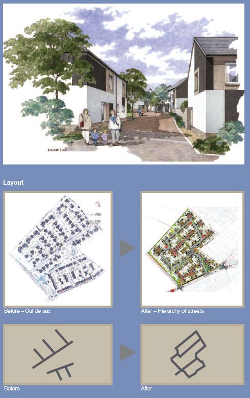
John Thompson and Partners
Getting the design right
The issues around good street design are highly dependent on context and may vary considerably in their nature and complexity from one circumstance to another. However, an approach which is underpinned by a consideration of the six qualities of successful places set out in Designing Places has clear benefits as a methodology to ensure that key issues are addressed. This policy statement elaborates on issues of street design in relation to these qualities and also describes an approach to the development of well-designed streets from large-scale to detailed considerations.
policy
- Street design should meet the six qualities of successful places, as set out in Designing Places
- Distinctive
- Distinctive
- Safe & pleasant
- Easy to move around
- Welcoming
- Adaptable
- Resource efficient
These six qualities provide a framework which should be used when considering street design. To help show how they relate to each other, the table on the following pages identifies some of the key considerations which relate to 'quality'. This information is then further supported by more detailed technical information on how to create good street design.
Key considerations for street design
| distinctive |
safe & pleasant |
easy to move around |
welcoming |
adaptable |
resource efficient |
|---|---|---|---|---|---|
| Street design should respond to local context to deliver places that are distinctive |
Streets should be designed to be safe and attractive places |
Streets should be easy to move around for all users and connect well to existing movement networks |
Street layout and detail should encourage positive interaction for all members of the community |
Street networks should be designed to accommodate future adaptation |
Street design should consider orientation, the integration of sustainable drainage and use attractive, durable materials that can be easily maintained |
| Block structure The urban form should be distinctive with landmarks and vistas that provide good orientation and navigation of an area Context and character The requirements and impact of pedestrians, cycles and vehicles should be reconciled with local context to create streets with distinctive character Opportunities should be taken to respond to, and to derive value from, relevant elements of the historic environment in creating places of distinctive character |
Pedestrians and cyclists Street user hierarchy should consider pedestrians first and private motor vehicles last Street design should be inclusive, providing for all people regardless of age or ability Achieving appropriate traffic speed Design should be used to influence driver behaviour to reduce vehicle speed to levels that are appropriate for the local context and deliver safe streets for all Reducing clutter Signs and street markings should be kept to a minimum and considered early in the design process Street lighting should be as discreet as possible, but provide adequate illumination Street furniture should be located for maximum benefit and to reduce pedestrian obstruction |
Connections within a place Street design should provide good connectivity for all modes of movement and for all groups of street users respecting diversity and inclusion Public transport Public transport planning should be considered at an early stage in the design process Junction types and arrangements Junctions should be designed with the considerations of the needs of pedestrians first Junctions should be designed to suit context and urban form - standardised forms should not dictate the street pattern |
Walkable neighbourhoods Street layouts should be configured to allow walkable access to local amenities for all street users Streets for people Streets should allow for and encourage social interaction |
Connections to wider networks Street patterns should be fully integrated with surrounding networks to provide flexibility and accommodate changes in built and social environments Integrating parking Parking should be accommodated by a variety of means to provide flexibility and lessen visual impact Service and emergency vehicles Street layouts should accommodate emergency and service vehicles without compromising a positive sense of place |
Orientation Orientation of buildings, streets and open space should maximise environmental benefits Drainage Streets should use appropriate SUDS techniques as relevant to the context in order to minimise environmental impacts Utilities The accommodation of services should not determine the layout of streets or footways Planting Street design should aim to integrate natural landscape features and foster positive biodiversity Materials Materials should be distinctive, easily maintained, provide durability and be of a standard and quality to appeal visually within the specific context |
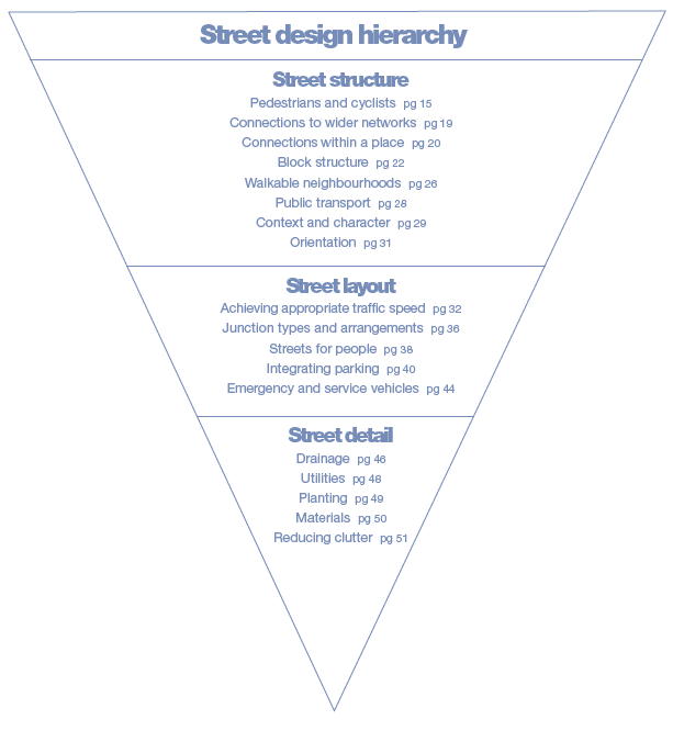
When designing streets, it is important to consider the relevant issues in a hierarchical way, working from issues of structure through to layout and geometry and on to matters of detail. The guidance in Designing Streets is structured in this way to help inform the understanding and approach of those involved in street design.
Guidance in support of the considerations in the preceding table is now ordered hierarchically, providing information on street design from macro to micro scales. The hierarchy is a guide to understanding and addressing relevant issues, however there will be overlaps between issues dependant on specific circumstances.
Street structure
Pedestrians and cyclists
Key considerations
- Street user hierarchy should consider pedestrians first and private motor vehicles last
- Street design should be inclusive, providing for all people regardless of age or ability
Pedestrians
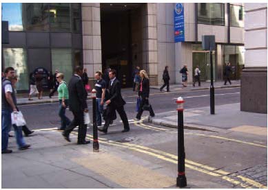
Walking is the most sustainable form of transport. Streets should be designed, not only to allow for walking, but to actively encourage it to take place. The propensity to walk is influenced not only by distance, but also by the quality of the walking experience. All streets should offer a pleasant walking experience. Sightlines and visibility towards destinations or intermediate points are important for navigating and personal security, and they can help people with cognitive impairment. Pedestrians may be walking with purpose or engaging in other activities such as play, socialising, shopping or just sitting. The issues for street design in relation to these activities are explored later in the document.

Gillespies
Within the context of Designing Streets, pedestrians include wheelchair users, mobility scooter users and people pushing wheeled equipment such as prams.
Pedestrian movement
The layout of our towns and cities historically suited pedestrian movement though, over time, motor vehicles have come to dominate our streets. A return to the prioritisation of pedestrian movement over vehicle movement has implications for the design of crossings and street interfaces.
Edinburgh New Town
The block dimensions are of a scale that encourages walking
Surface level crossings can be of a number of types, as outlined below:
- Uncontrolled crossings - should have dropped kerbs.
- Informal crossings - can be created through careful use of paving materials and street furniture to indicate a crossing place which encourages slow-moving traffic to give way to pedestrians.
- Formal crossings - of which the Zebra crossing type involves the minimum delay for pedestrians when used in the right situation. There are four types of Signalised crossings - Pelican, Puffin, Toucan and Equestrian crossings. Puffin crossings have a variable crossing time; they use pedestrian detectors to match the length of the crossing period to the time pedestrians take to cross. Toucan and Equestrian crossings operate in a similar manner to Puffin crossings except that cyclists can also use Toucan crossings, while Equestrian crossings have a separate crossing for horse riders. Equestrian crossings can also be combined with cycle and pedestrian facilities. Signalised crossings are preferred by the older people and people with visual and mobility impairments.
There are a number of general principles which should be observed in the design of crossing places as follows:
- Consideration should be given to the raising of crossings, of whichever type to footway height where possible. Footway surfacing of contrasting colour should be used to demonstrate pedestrian priority and tactile paving should be used to indicate the change in condition to visually impaired pedestrians.
- Pedestrian refuges and kerb build-outs, used separately, or in combination, effectively narrow the carriageway and so reduce the crossing distance.
- Footbridges and subways should be avoided; they are usually unsuccessful and create hostile environments - the ground level should be prioritised for pedestrians.
- Pedestrian desire lines should be kept as straight as possible at side-street junctions. Small corner radii minimise the need for pedestrians to deviate from their desire line.
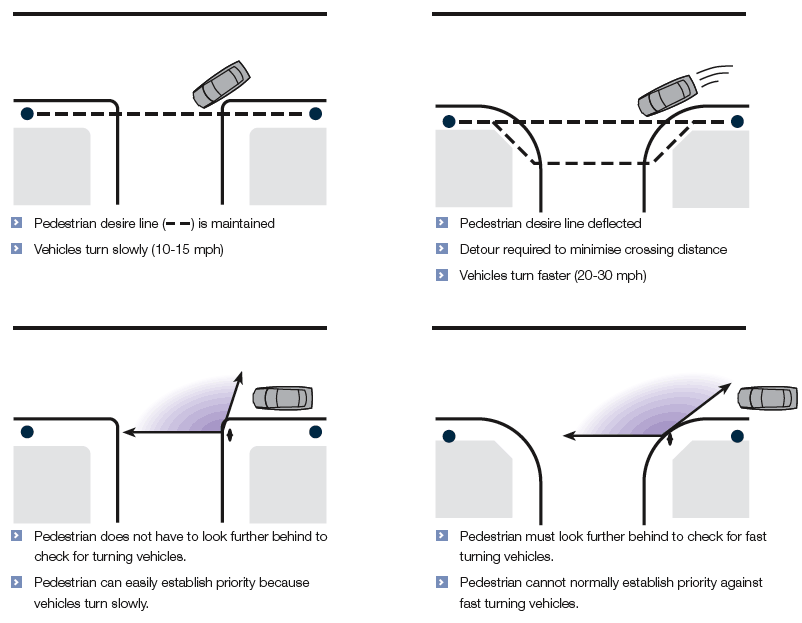
The effects of corner radii on pedestrians
Devon County Council
With small corner radii, large vehicles may need to use the full carriageway width to turn. Swept-path analysis can be used to determine the minimum dimensions required. The footway may need to be strengthened locally in order to allow for larger vehicles occasionally overrunning the corner.
The approach to footways and pedestrian movement should be design-led. Any footway should be fit for purpose, but should give primary importance to delivering positive, attractive spaces. There is no maximum width for footways. In lightly-used streets (such as those with a purely residential function), the unobstructed width for pedestrians should generally be 1.5 - 2 m, however this can be varied to accommodate character and practical requirements. Additional width should be considered between the footway and a heavily used carriageway, or adjacent to gathering places, such as schools and shops.
Raised crossover, but located away from the desire line for pedestrians and therefore ignored - the crossover should be nearer the junction with, in this case, a steeper ramp for vehicles entering the side street
This can cause particular difficulty for pedestrians with mobility or visual impairments
Andrew Cameron WSP
Porch roofs, awnings, garage doors, bay windows, balconies or other building elements should allow for clear movement of pedestrians underneath.
Designers should attempt to keep pedestrian (and cycle) routes as near to level as possible along their length and width, within the constraints of the site. Longitudinal gradients should ideally be no more than 5%, although topography or other circumstances may require steeper gradients.
Inviting pedestrian link
John Thompson & Partners, Queen Elizabeth Park
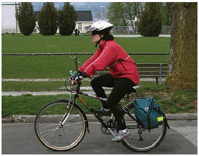
Cyclists
Cyclists should generally be accommodated on the carriageway. Only where traffic volumes and speeds are high should the need for a cycle lane be considered.
Cyclists are more likely to choose routes that enable them to keep moving. Routes that take cyclists away from their desire lines and require them to concede priority to side-street traffic are less likely to be used. Designs should contain direct, barrier-free routes for cyclists.
The design of junctions affects the way motorists interact with cyclists. It is recommended that junctions are designed to promote slow motor-vehicle speeds. This may include short corner radii as well as vertical deflections.
- Cycle tracks are more suited to leisure routes over relatively open spaces. In a built-up area, they should be well overlooked.
- The headroom over routes used by cyclists should normally be 2.7 m (minimum 2.4 m). The maximum gradients should generally be no more than 3%, or 5% maximum over a distance of 100 m or less, and 7% maximum over a distance of 30 m or less. However, topography may dictate the gradients, particularly if the route is in the carriageway. A cycle route with a steep gradient may be better than none at all.
Cycling by Design 2010, alongside the Cycling Action Plan for Scotland, is due for publication in April 2010 and will be available at www.transportscotland.gov.uk.
Local Transport Note 2/08 Cycle Infrastructure Design 6 contain further details on designing for cycles.
John Thompson & Partners
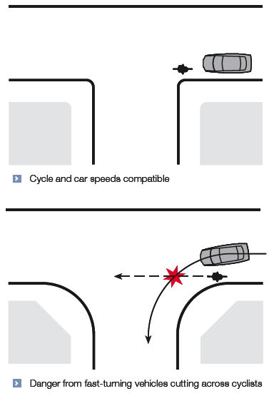
The effect of corner radii on cyclists near turning vehicles
Devon County Council
Inclusive design
Inclusive design should be a first principle in street design. The Disability Discrimination Act 2005 7 makes it unlawful for a public authority, without justification, to discriminate against a disabled person when exercising its functions.
PAN 78, Inclusive Design 8 , contains information on inclusion and the roles and responsibilities of those involved in the built environment. An inclusive environment is one which can be used by everyone, regardless of age, gender, ethnicity or disability.
Issues around disability and age are especially relevant to those involved in the design of the external environment. Particular effort should be made to engage with representatives from these groups and consider specific requirements when developing street design. This should be undertaken at an early stage in the design process.
The requirements upon designers and decision makers regarding mobility equality are discussed later in this document in the Annex.
The Department for Transport document, Inclusive Mobility 9 provides detailed information on inclusive design. The Transport Scotland document, Disability Discrimination Act: Good Practice Guide for Roads 10 contains information on inclusive design in the construction, operation and maintenance of road infrastructure.
Connections to wider networks
Key consideration
- Street patterns should be fully integrated with surrounding networks to provide flexibility and accommodate changes in built and social environments
Connecting layouts to their surroundings
Street networks should, in general, be connected. Connected or 'permeable' networks encourage walking and cycling, and make navigation through places easier. They also lead to a more even spread of motor traffic throughout an area and so avoid the need for distributor roads with less desirable place characteristics.
Permeability of places is a crucial component in good street design. Internal permeability is important, but any area should also be properly connected with adjacent street networks. A development with poor links to the surrounding area creates an enclave which encourages movement to and from it by car rather than by other modes. New developments and alterations to existing street networks should be designed with multiple access points that connect with, and complement, existing street patterns.
The movement framework
A key consideration for achieving sustainable development is how design can influence the way that people choose to travel. Designers need to respond to a wide range of policies aimed at making car use a matter of choice rather than habit or dependence. Regional and local transport strategies can directly inform the design process as part of the policy implementation process.
It is recommended that the movement framework for a new development is based on the user hierarchy in the previous section, Pedestrians and cyclists. Applying the hierarchy will lead to a design that increases the attractiveness of walking, cycling and the use of public transport. Delays to cars resulting from adopting this approach are unlikely to be significant in residential areas. The movement framework should also take account of the form of the buildings, landscape and activities that contribute to the character of the street and the links between new and existing routes and places.
Internally permeable neighbourhoods lacking direct connections with one another - to be avoided
Streets and Patterns, Marshall
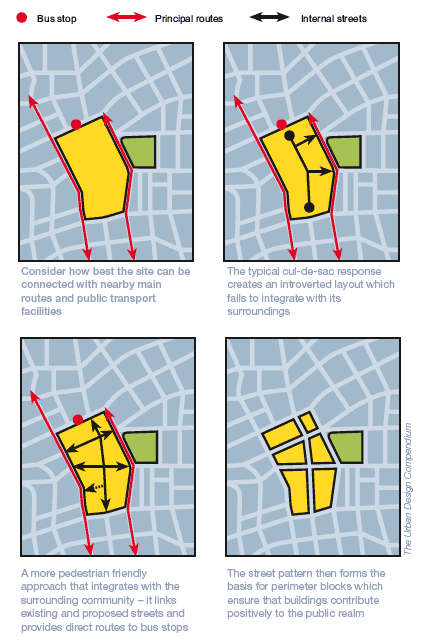
Integrating new developments into the existing urban fabric is essential.
The Urban Design Compendium
Connections within a place
Key consideration
- Street design should provide good connectivity for all modes of movement and for all groups of street users, respecting diversity and inclusion
Connected street networks
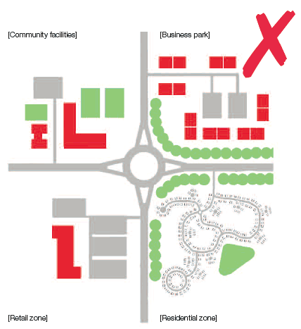
In recent decades, the dominant patterns of development have been those in which housing, employment, retail and other facilities have been created in a segmentary fashion or zoned in separate areas, which are often poorly connected with one another. Such developments often increase the reliance on car use and discourage movement on foot.
Government policy now supports the creation of mixed-use neighbourhoods with well-connected street patterns, where daily needs are within walking distance of most residents. Layouts built on these more traditional lines are likely to be more adaptable and will lead to lower car use, thus contributing to wider transportation and environmental objectives.
The dispersed and zoned layout, as shown in the suburban sprawl diagram opposite, should not be used when designing new developments and this model should be avoided, where practicable, when considering existing or infill developments.
Suburban sprawl
Developments and streets should generally be structured around a compact and walkable layout. The diagram illustrating mixed and connected neighbourhoods, opposite, illustrates how this can be achieved; these layouts have a mix of uses spread throughout, rather than a zoned approach to use.
To create a permeable network, it is generally recommended that streets with one-way operation are avoided. They require additional signs and result in longer vehicular journeys and higher speed.
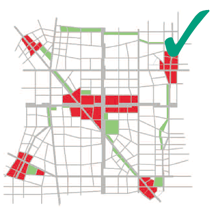
Mixed and connected neighbourhoods
Case study
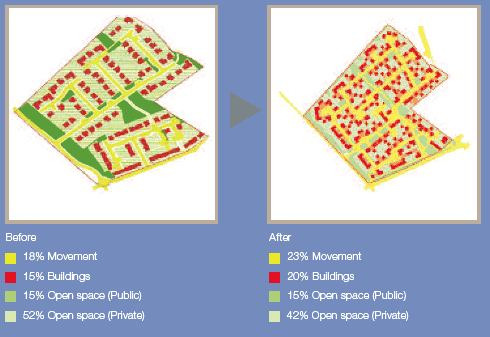
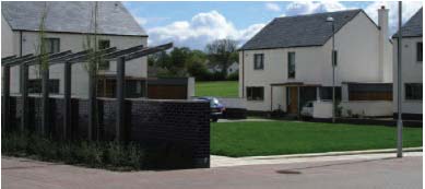
Residential streets: Polnoon
Polnoon is located at the western edge of Eaglesham village, an 18th-century Conservation Area village in East Renfrewshire. Planning permission for the site had been obtained in 2006 for the development of housing in a typical standards-led, cul-de-sac layout.
In 2008, the Scottish Government, Mactaggart & Mickel Ltd and East Renfrewshire Council worked in a collaborative process to re-design the site to develop a new neighbourhood in accordance with the principles of Designing Streets and Designing Places.
The sequence of diagrams illustrates the differences between the initial cul-de-sac layout and the more permeable, pedestrian-friendly design developed through the collaborative re-design process.
The new layout offers a clear hierarchy of shared surface public realm spaces - streets, lanes, courtyards and a central square - which were designed to reduce vehicle speeds and create a more pedestrian-friendly environment. The re-designed new neighbourhood contains improved spatial permeability, an increased density from 92 to 121 dwellings and a more contextual treatment for standard house type elevations. Planning permission and RCC processes were run in parallel.
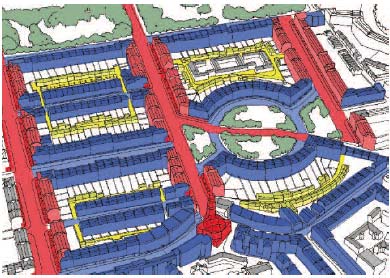
B-Plan
Bavarian B Plan: Bringing movement, buildings and open space all together
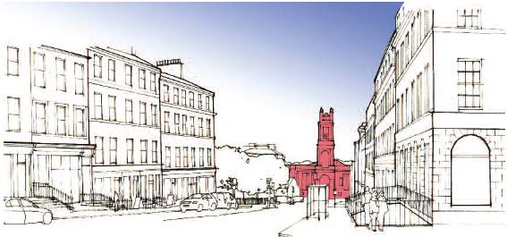
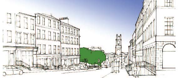
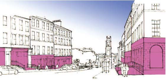
A simple, but key technique which was used in developing the Polnoon masterplan was the Bavarian B-Plan tool. This is an effective method for developing ideas by colour coding the three key issues in a layout: 'movement' in yellow, 'buildings' in red and 'open space' in green. The B-Plan images to the right show the differences between the previous consent and the re-designed masterplan.
The Polnoon project sets a new standard for residential development across Scotland. The project clearly illustrates that, by putting place before movement when considering the design of streets, a better place can be created.
Detailed information on the Polnoon project can be found at: www.scotland.gov.uk/Topics/Built-Environment/AandP/Projects/Polnoon
Block structure
Key consideration
- The urban form should be distinctive with landmarks and vistas that provide good orientation and navigation of an area
Structure
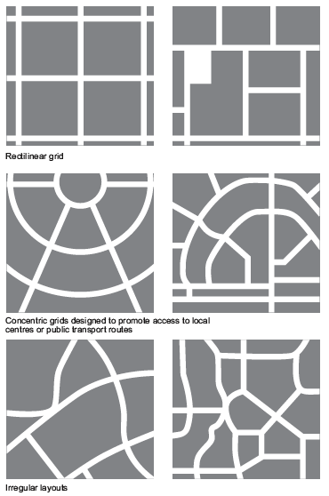
The structure of a street network can take a variety of forms, from formal grid layouts to more irregular arrangements.
It is important to consider the street structures that are appropriate in any given situation. It may be that an existing grid structure is continued in order to maintain connectivity or perhaps it may be more appropriate to break an existing pattern to respond to important external factors such as vistas, topography or significant building lines. What is important is that responses to layout structure should be design-led and responsive to context. They should not be the product of standard approaches or the application of inappropriate models.
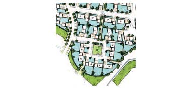
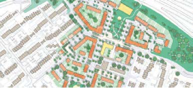
The principle of integrated access and movement means that the perimeter block is usually an effective structure for residential neighbourhoods. A block structure works in terms of providing direct, convenient, populated and overlooked routes. In addition, it makes efficient use of land, offers opportunities for enclosed private or communal gardens, and is a tried and tested way of creating quality places.
Within a block structure, the designer has more freedom to create innovative layouts. The layouts illustrated in this section, and variations on them (such as a 'broken grid' with the occasional courtyard), are recommended when planning residential and mixed-use neighbourhoods.
Consideration should be given to the layout and impact of Sustainable Urban Drainage Systems ( SUDS) when working on street and block layouts, as these can have determining effects on the overall urban structure. Detailed guidance on SUDS is given in this document in the section Street detail, Drainage.
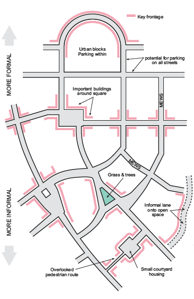
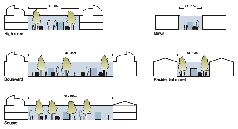
Diagram illustrating a range of street and place typologies
Andrew Camreon WSP
Street patterns
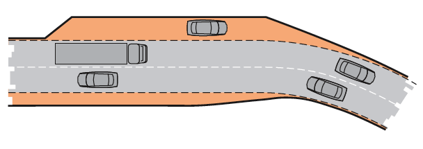
Short and curved or irregular streets can contribute to variety and a sense of place, and may also be appropriate where there are topographical or other site constraints, or where there is a need to introduce some variation for the sake of interest. However, layouts that use excessive or gratuitous curves should be avoided, as they are less efficient, reduce legibility and make access for pedestrians and cyclists less direct.
Straight streets maximise connections between places and can better serve the needs of pedestrians who prefer direct routes. The regular spacing of junctions, where drivers are required to slow, can be an effective method for reducing vehicle speeds on straight road layouts.
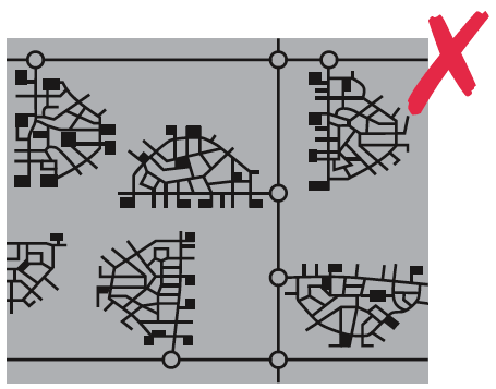
Conventional culs-de sac, are strongly discouraged. The preference is for networked routes and spaces which connect new residential and mixed use areas together and link with existing development forms.
Short culs-de sac may occasionally be required because of topography, boundary or other constraints. Caution must, however, be exercised when planning for culs-de sac, as they concentrate traffic impact on a small number of dwellings, require turning heads that are wasteful in land terms and lead to additional vehicle travel and emissions, particularly by service vehicles. Through connections for pedestrians and cyclists should be provided where possible but should be wide, well lit and well overlooked with active frontages.
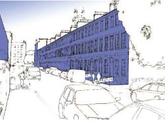
Variations in block structure
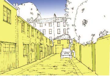
Backs and fronts
In general, it is recommended that different treatments are employed in the design of the fronts and backs of houses and other buildings. The basic principle is 'public fronts and private backs'.
Exceptions to this may be employed where the building form contains a double frontage, such as a colony house type. Colony streets can increase the density of a typical terrace and provide positive street edges in a distinctive manner.
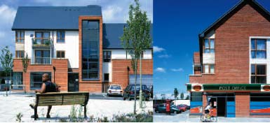
Busier streets should also follow this principle. Frontage development and multiple access points on busier streets add to activity intensity and traffic calming as well as a sense of place.
Section through colony street illustrating double frontage
Width
Width between buildings is a key dimension and needs to be considered in relation to function and aesthetics. There are no fixed rules on street widths but account should be taken of the variety of activities taking place in the street and of the scale of the buildings on either side. The distance between frontages in residential streets typically ranges from 10 m to 18 m, although there are examples of widths significantly less than this working well.
Rigid standards on street widths should be avoided and new streets should be laid out with consideration given to the relationship between scale and the nature of the space created.
Height
The public realm is defined by height as well as width or, more accurately, the ratio of height to width. It is therefore recommended that the height of buildings (or mature trees where present in wider streets) is in proportion to the width of the intervening public space to achieve the level of enclosure appropriate to the character and function of the street. Where building height is increased, it is important to avoid creating spaces with an oppressive or claustrophobic nature.
Length
Street length can have a significant effect on the quality of a place. Acknowledging and framing vistas and landmarks can help bring an identity to a neighbourhood and orientate users. However, long straights can encourage high traffic speeds, which should be mitigated through careful design (see Street Layout section - Achieving Appropriate Traffic Speeds).
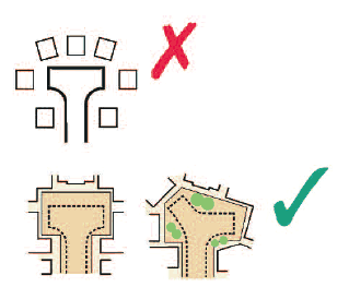
Buildings at junctions
The arrangement of buildings and footways has a major influence on defining the space at a junction. It is better to design the junction from this starting point rather than purely on vehicle movement. In terms of streetscape, a wide carriageway with tight, enclosed corners makes a better junction than cutback corners with a sweeping curve. This might involve bringing buildings forward to the corner. Junction treatments are explored in more detail in the Street Layout section.
Variation in building height can add visual interest
John Thompson & Partners
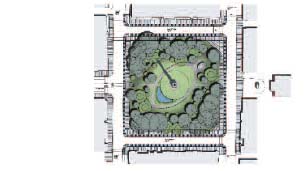
Squares & spaces
A street and block structure can be enhanced with punctuations of public space. This may take the form of parks, green edges or formal and informal squares. The introduction of small, informal squares in a residential area can support navigation, provide social areas for people to gather and children to play, slow traffic speed and create positive character.
The design of squares, both small and large, should respond to the context of the place. A square will not be successful unless it is aligned with the potential activities of a place and the building forms.
| Small residential square |
Malcolm Fraser Architects |
| Local neighbourhood square |
HTA, Oakridge village |
| Large urban square |
Gillespies |
Other layout considerations
The layout of a new housing or mixed-use area should take account of the following factors:
- the need to reduce the dominance of vehicle traffic;
- the need to mitigate noise pollution such as from roads or railways;
- the importance of orientation, variety and visual interest (The provision of views and vistas, landmarks, gateways and focal points are means to emphasise urban structure, hierarchies and connections.);
- the need for crime prevention, including the provision of defensible private and communal space, and active, overlooked streets (An appropriate mix of uses can often encourage activity and movement at all times.);
- the management of the transition from the public to the private realm (The space between the fronts of buildings and carriageways, footways or other public spaces needs to be carefully considered. Continuous building lines are preferred as they provide definition to, and enclosure of, the public realm.);
- the handling of building lines (Where no front garden is provided, the setback of dwellings from the street is a key consideration in terms of: defining the character of the street determining a degree of privacy; amenity space for plants or seating, etc.; and functional space for rubbish bins, external utility meters or storage, including secure parking for bicycles.); and
- the handling of car parking (Keeping garages and parking areas level with, or behind, the main building line can be aesthetically beneficial in streetscape terms.).
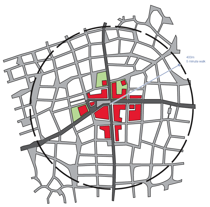
Walkable neighbourhoods
Key consideration
- Street layouts should be configured to allow walkable access to local amenities for all street users
The walkable neighbourhood
Walkable neighbourhoods are characterised by having a range of facilities within 5 minutes (up to about 400m) walking distance of residential areas which residents may access comfortably on foot. Where amenities cannot be provided within this area, good public transport links to relevant facilities should be accessible.
In many cases, it may be better for a new development to reinforce existing centres and facilities rather than providing alternative facilities.
Andrew Cameron WSP
Walkable neighbourhoods should be on an appropriate scale, with pedestrian routes matching desire lines as closely as possible. Permeable networks help minimise walking distances.
Good connectivity and the formation of local or district centres are key to establishing walkable neighbourhoods. By concentrating facilities along key routes and junctions, particularly at the convergence of main routes, neighbourhood centres can be established that contribute both practical services and a local identity to a place. Within the larger context, walkable neighbourhoods should have good linkages to other local centres, building a larger network of distinct neighbourhoods. The hierarchy and scale of these neighbourhoods can vary within a town or city; the greater the density of development, the more facilities can be supported.
Density is also an important consideration in reducing reliance on the private car. Scottish Planning Policy encourages a flexible approach to density, reflecting the desirability of using land efficiently and the need to promote higher density development in places well served by public transport. Residential densities should be planned to take advantage of proximity to activities, or to good public transport linking those activities.
Public transport
Key consideration
- Public transport planning should be considered at an early stage in the design process
Bus routes
The principal streets within a development should be the streets on which public transport runs. These should be identified in the design process, working in partnership with public transport operators. Bus routes and stops should form key elements of the walkable neighbourhood. Designers and local authorities should try to ensure that development densities will be high enough to support a good level of service without long-term subsidy. Layouts designed with strong connections to local networks, and which avoid long one-way loops or long distances without passenger catchments, are likely to be more viable.
Using a residential street as a bus route need not require restrictions on direct vehicular access to housing. Detailed requirements for streets designated as bus routes can be determined in consultation with local public transport operators. Streets on bus routes should not generally be less than 6.0 m wide (although this could be reduced on short sections with good inter-visibility between opposing flows). The presence and arrangement of on-street parking, and the manner of its provision, may affect width requirements.
Swept-path analysis can be used to determine the ability of streets to accommodate large vehicles. When considering the level of provision required for the movement of buses, account should be taken of the frequency and the likelihood of two buses travelling in opposite directions meeting each other on a route.
Bus stops
In new developments, it is essential to consider the siting of public transport stops and related pedestrian desire lines at an early stage of design. Close co-operation is required between public transport operators, the local authorities and the developer.
- Bus stops should be sited so they can be easily accessed by all pedestrians.
- Bus stops should be placed near junctions so that they can be accessed by more than one route on foot, or near specific passenger destinations. (schools, shops, etc.)
- The bus should generally stop on the street and not in a lay-by.
- Bus stops should be high-quality places that are safe and comfortable to use.
- Footways at bus stops should be wide enough for waiting passengers while still allowing for pedestrian movement along the footway. This may require local widening at the stop.
- Provision should be made within the streetscape for features that that assist passengers getting on and off buses. This may involve areas of raised footway. It is important that such features are integrated within the overall design of the street and do not pose difficulties for those with visual impairments.
Bus tracking in residential layout
Context and character
Key consideration
- The requirements and impact of pedestrians, cycles and vehicles should be reconciled with local context to create streets with distinctive character
- Opportunities should be taken to respond to, and to derive value from, relevant elements of the historic environment in creating places of distinctive character
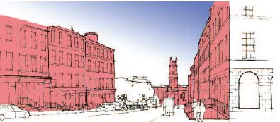
Character
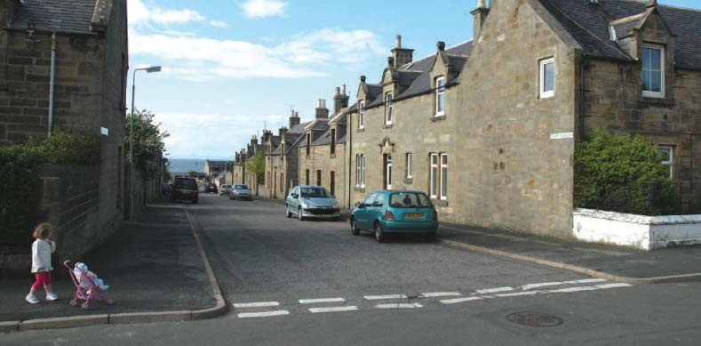
Streets and the public realm at large play an important part in the development and expression of local character and culture. The character of a place is not determined by the particular materials or physical appearance of a place alone, but also by the patterns of movement and social interaction that it produces. When considering the structure of streets, it is important that street and block forms are selected that will enhance the character of an area.
Street character types in new residential developments should be determined by a sensitive response to site conditions as well as the relative importance of both place and movement functions. When developing layouts, consideration should be given to the character of each individual street as well as the overall urban structure.
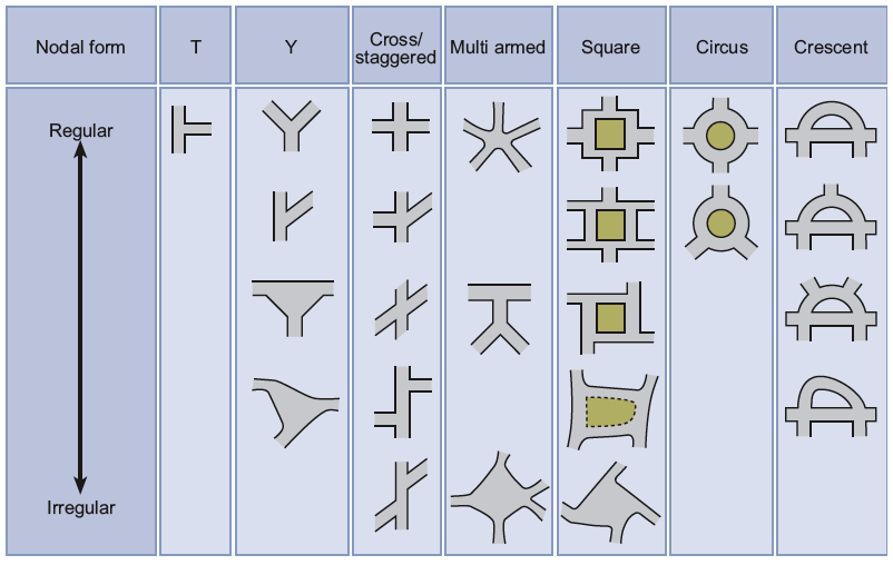
Scotland has a wide range of distinctive street typologies and the successful arrangement of these can result in networks with positive characters. When developing street networks it can be useful to consider typologies such as the following, in order to create distinctive environments:
- high street
- mixed-use street
- square
- crescent/circus
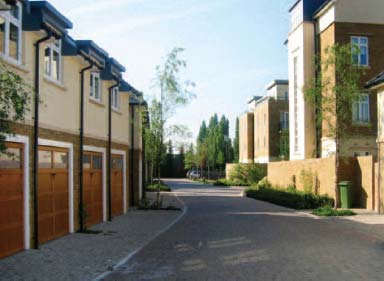
- mews
- terrace/row
- colony
- tenement block
- avenue
- courtyard
- cross
- lane/loan
- vennel/wynd
The above list is not exhaustive. It is important that the individual characteristics of any of the above street types are well defined and meaningful. Site specific design codes can ensure that the principal elements of a street's character are controlled and distinct.
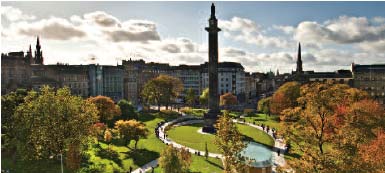
The street hierarchy of Edinburgh New Town accommodates variety of character within a cohesive urban structure
Main avenue mixed-uses/primary zone
Residential street/secondary zone
Residential and service lane/tertiary zone
Variety
Character can be enhanced and emphasised by variety in the streetscape. Punctuating key views with landmarks or green edges can provide visual cues that aid navigation as well as helping to develop areas of individual character within the overall urban structure. Developing a series of linked spaces with distinctive identities can also aid navigation while providing a cohesive character for a neighbourhood. By employing a network of varied streets, each with particular characteristics, a diverse streetscape with varied visual interest can be achieved. Variation in scale and density can develop areas with distinct physical characteristics as well as reflecting the types of activities that take place in the area.
Landmark/vista stop helps to develop a unique character, emphasise street hierarchy and aid navigation
Green edge signifies a significant junction and a change in street pattern as well as offering visual relief and local amenity
Ground floor commercial and retail space also emphasises the street hierarchy, provides amenity and an active street edge
Orientation
Key consideration
- Orientation of buildings, streets and open space should maximise environmental benefits
The orientation of streets can have a large impact on the environmental performance of buildings as well as contributing to perceptions of safety and attractiveness.
Solar impact
Bright, sunny streets can foster a positive sense of place. The layout of streets should be considered in relation to building heights to maximise the amount of light reaching the public realm. This is particularly important in areas where people gather and activities take place. Local shops and facilities should be arranged to provide southerly aspects to the activities that will most benefit from bright, attractive external space.
By arranging streets so that buildings are able to maximise solar gain, it is possible for buildings to reduce heat and light requirements. Principal elevations should address the sun path wherever possible and the presentation of blank gables to the south should be avoided.
On occasion, it may be that narrow, intimate streets are appropriate to a particular context and will not require to have as direct a relationship to the sun path as a large public boulevard or square.
Prevailing wind
Traditionally, many street layouts evolved to respond directly to the prevailing wind direction. This led to streets where pedestrians were sheltered from the extremities of the environment, ultimately producing streets where people were more likely to gather and take ownership of a place. This also led to patterns of development that were particular or unique to the microclimate of a settlement and helped to evolve a distinctive local design response.
Designers should take prevailing wind conditions into account to maximise on-street shelter and also to minimise the impact of cold air infiltration into buildings. This can have an impact on the direction of streets, the scale of individual buildings, street width and the relationship of a settlement to natural landscape features.
Street layout
Achieving appropriate traffic speed
Key consideration
- Design should be used to influence driver behaviour to reduce vehicle speed to levels that are appropriate for the local context and deliver safe streets for all
For residential streets, a maximum design speed of 20 mph should normally be an objective.
Designers should aim to create streets that control vehicle speeds naturally by well-crafted design from the outset rather than through unsympathetic traffic-calming measures added at the end of the design process.
The provision of separate pedestrian and/or cycle routes away from motor traffic should only be considered as a last resort. Research has shown that the presence of pedestrians has an effect in reducing traffic speeds.
Evidence from traffic calming schemes suggests that speed-controlling features are needed at intervals of around 60-80m in order to achieve speeds of 20 mph or less. Straight and uninterrupted links should therefore be limited to this range to help ensure that the arrangement has a natural traffic-calming effect. Designs should not rely solely on conventional traffic calming techniques, such as speed cushions and humps; these do little to develop a positive sense of place. Instead, speed-controlling features should be built into the layout of the street, taking advantage of building alignment, parking, road narrowings, landscaping and other design features, rather than resorting solely to vertical deflection.
The range of traffic-calming measures available act in different ways:
- Psychology and perception - play a strong part in influencing driver behaviour. Street features and human activity can influence the speed at which people choose to drive. Features likely to be effective include:
- edge markings that visually narrow the road - speed reduction is likely to be greatest where the edging is textured to appear unsuitable on which to drive;
- buildings in close proximity to the street;
- reduced carriageway width;
- physical features in the carriageway;
- features associated with potential activity in, or close to, the carriageway, such as pedestrian refuges;
- on-street parking, particularly when the vehicles are parked in blocks on alternate sides of the street, either in echelon formation or perpendicular to the carriageway;
- the types of land use associated with greater numbers of people, for example shops; schools and places of work; and
- landscaping.
- Street dimensions - can have a significant influence on speeds. Keeping lengths of street between junctions short is particularly effective.
- Reductions in forward visibility - are associated with reduced driving speeds.
- Changes in priority/or no priority - at junctions. This can be used to disrupt flow and therefore bring overall speeds down.
- Physical features - involving vertical or horizontal deflection can be very effective in reducing speed.
- Materials - can reduce speed by both visual perception and by physical characteristics, such as cobbled surfaces.
Reductions in carriageway width are most effective in reducing driving speed.
Trees planted in the highway at Newhall, Harlow, help to reduce vehicle speeds.
EDAW
Stopping sight distance
The stopping sight distance ( SSD) is the distance within which drivers need to be able to see ahead and stop from a given speed.
The SSD values used in Designing Streets are based on research into deceleration rates, driver perception-reaction times and speed. These SSD values are appropriate for residential and lightly trafficked streets. The table below shows the effect of speed on SSD. These values are independent of traffic flow or type of road. It is recommended that they are used on all streets with 85th percentile wet weather speeds up to 60 kph.
Below around 20 mph, shorter SSDs themselves may not achieve low vehicle speeds: the design of the whole street and how this will influence speed needs to be considered at the start of the process; e.g. the positioning of buildings and the presence of on-street parking.
Further information on SSDs, including details of the calculation formula, and also the relationship between visibility and speed is available in TRL Report No. 332 11 and TRL Report No. 661 12 .
| Speed |
Kilometres per hour |
16 |
20 |
24 |
25 |
30 |
32 |
40 |
45 |
48 |
50 |
60 |
|---|---|---|---|---|---|---|---|---|---|---|---|---|
| Miles per hour |
10 |
12 |
15 |
16 |
19 |
20 |
25 |
28 |
30 |
31 |
37 |
|
| SSD (metres) |
9 |
12 |
15 |
16 |
20 |
22 |
31 |
36 |
40 |
43 |
56 |
|
| SSD adjusted for bonnet length |
11 |
14 |
17 |
18 |
23 |
25 |
33 |
39 |
43 |
45 |
59 |
Visibility requirements
Visibility should be checked at junctions and along the street. Visibility is measured horizontally and vertically.
Using plan views of proposed layouts, checks for visibility in the horizontal plane ensure that views are not obstructed by vertical obstructions.
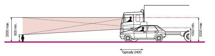
Checking visibility in the vertical plane is then carried out to ensure that views in the horizontal plane are not compromised by obstructions such as the crest of a hill, or a bridge at a dip in the road ahead. It also takes into account the variation in driver eye height and the height range of obstructions. Eye height is assumed to range from 1.05 m (for car drivers) to 2 m (for lorry drivers). Drivers need to be able to see obstructions 2 m high down to a point 600 mm above the carriageway.
Visibility splays at junctions
The visibility splay at a junction ensures there is adequate inter-visibility between vehicles on the major and minor arms.
The distance back along the minor arm from which visibility is measured is known as the X distance. It is generally measured back from the 'give way' line (or an imaginary 'give way' line if no such markings are provided). This distance is normally measured along the centreline of the minor arm for simplicity, but in some circumstances (for example where there is a wide splitter island on the minor arm) it will be more appropriate to measure it from the actual position of the driver.
The Y distance represents the distance that a driver who is about to exit from the minor arm can see to his left and right along the main alignment. For simplicity, it is measured along the nearside kerb line of the main arm, although vehicles will normally be travelling a distance from the kerb line. The measurement is taken from the point where this line intersects the centreline of the minor arm (unless, as above there is a splitter island in the minor arm).
When the main alignment is curved and the minor arm joins on the outside of a bend, another check is necessary to make sure that an approaching vehicle on the main arm is visible over the whole of the Y distance. This is done by drawing an additional sight line which meets the nearest wheel track at a tangent.
Some circumstances make it unlikely that vehicles approaching from the left on the main arm will cross the centreline of the main arm - opposing flows may be physically segregated at that point, for example. If so, the visibility splay to the left can be measured to the centreline of the main arm.
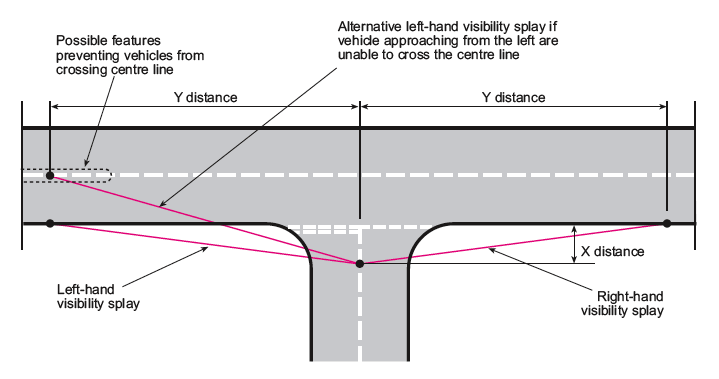
X and Y distances
An X distance of 2.4 m should normally be used in most built-up situations, as this represents a reasonable maximum distance between the front of the car and the driver's eye.
A minimum figure of 2 m may be considered in some very lightly-trafficked and slow-speed situations, but using this value will mean that the front of some vehicles will protrude slightly into the running carriageway of the major arm. The ability of drivers and cyclists to see this overhang from a reasonable distance, and to manoeuvre around it without undue difficulty, should be considered.
Using an X distance in excess of 2.4 m is not generally required in built-up areas.
The Y distance should be based on values for SSD.
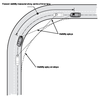
Forward visibility
Forward visibility is the distance a driver needs to see ahead to stop safely for obstructions in the street. The minimum forward visibility required is equal to the minimum SSD. It is checked by measuring between points on a curve along the centreline of the inner traffic lane. Consideration should be given to vertical geometry and any other obstructions.
There will be situations where it is desirable to reduce forward visibility in conjunction with other methods to control traffic speeds.
An example of the reduction in forward visibility to reduce vehicle speed
Andrew Cameron WSP
Visibility along the street edge
Vehicle exits at the back edge of the footway mean that emerging drivers will have to take account of people on the footway. The absence of wide visibility splays at private driveways will encourage drivers to emerge more cautiously. Consideration should be given to whether this will be appropriate, taking into account the following:
- the frequency of vehicle movements;
- the amount of pedestrian activity; and
- the width of the footway.
Obstacles to visibility
Parking in visibility splays in built-up areas is quite common, yet it does not appear to create significant problems in practice. Defined parking bays can be provided outside the visibility splay if required, and the use of tracked streets that allow for informal parking is also an option. Encroachment of parking space into visibility splays should be avoided where practical.
The impact of other obstacles, such as street trees and street lighting columns, should be assessed in terms of their impact on the overall envelope of visibility. In general, occasional obstacles to visibility that are not large enough to fully obscure a whole vehicle or a pedestrian, including a child or wheelchair user, will not have a significant impact on road safety.
Measurement of forward visibility
Junction types and arrangements
Key consideration
- Junctions should be designed with the considerations of the needs of pedestrians first
- Junctions should be designed to suit context and urban form - standardised forms should not dictate the street pattern
Junctions
The success of a well-designed junction frequently derives from the way in which buildings frame the space in which the junction sits. Decisions on building placement should be made first, with the quality of the space in mind, and the junction then designed to suit the space created.
Junctions that should be used in residential areas include:
- crossroads and staggered junctions;
- T and Y junctions;
- formal and informal squares; and
- mini roundabouts.
Junctions are generally places of high accessibility and good natural surveillance. Junctions generally, and crossroads junctions in particular, are therefore ideal places for locating facilities such as public buildings, shops and public transport stops.
Junction design should facilitate direct pedestrian desire lines, and this will often mean using small corner radii. The use of swept path analysis will ensure that the junctions are negotiable by vehicles. However, consideration should be given to the robustness of the design and quality of construction to withstand any occasional vehicle overrun.
Crossroads are convenient for pedestrians, as they minimise diversion from desire lines when crossing the street. They also make it easier to create permeable and legible street networks.
Where designers are concerned about potential user conflict, they may consider placing the junction within a square or on a speed table.
Conventional roundabouts are not generally appropriate for residential developments. Mini-roundabouts may have some application in residential areas, as they cause less deviation for pedestrians and are easier for cyclists to use. In addition, they do not occupy as much land. Practitioners should refer to Mini-roundabouts: Good Practice Guidelines 13 .
Quadrant kerbstones used instead of large radii at junctions reduce the dominance of the carriageway and respond to pedestrian desire lines. This is reinforced by the placement and form of the adjacent buildings
David Nicol, WSP
Spacing of junctions
The spacing of junctions should be determined by the type and size of urban blocks appropriate for the development. Block size should be based on the need for permeability and, generally, tends to become smaller as density and pedestrian activity increases.
Smaller blocks create the need for more frequent junctions. This improves permeability for pedestrians and cyclists, and the impact of motor traffic is dispersed over a wider area. Junctions do not always need to cater for all types of traffic. Some of the arms of a junction may be limited to pedestrian and cycle movement only.
Turning areas
Connected street networks will generally eliminate the need for vehicles to turn around.
Where it is necessary to provide for vehicles turning (e.g. in a cul-de-sac or court), a tracking assessment should be made to indicate the types of vehicles that may be making this manoeuvre and how they can be accommodated. The turning space provided should relate to its environment, not specifically to vehicle movement, as this can result in a space with no use other than for turning vehicles. To be effective and usable, the turning space must be kept clear of parked vehicles. It is essential, therefore, that adequate parking is provided for residents in suitable locations.
Overrun areas
Overrun areas should generally be avoided in residential and mixed-use streets. They can:
- be visually intrusive;
- interfere with pedestrian desire lines; and
- pose a hazard for cyclists.
Overrun areas can, however, help to overcome problems with regular or high volume access for larger vehicles.
Frontage access
One of the key differences between streets with a 30 mph speed restriction or below and roads is that streets normally provide direct access to buildings and public spaces. This helps to generate activity and a positive relationship between the street and its surroundings. Providing direct access to buildings is also efficient in land-use terms.
It is recommended that direct access on roads with a 30 mph speed restriction is acceptable with flows of up to 10,000 vehicles per day.
Streets for people
Key consideration
- Streets should allow for and encourage social interaction
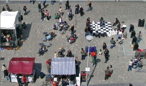
Streets as social spaces
The design of all streets should recognise the importance of creating places for people to enjoy, rather than simply providing corridors for the movement of traffic. Streets should generally be designed with a focus on social interaction.
A significant amount of interaction within a community takes place in the external environment, and street design should encourage this by creating inclusive social spaces where children can play, people can stop to chat, and other appropriate activities can take place safely. In order for this to occur, it is essential that vehicular traffic does not dominate the street.
The propensity for people to use a street as a social space is increased by careful design and by applying the user hierarchy where pedestrians are considered first, as indicated in the section Pedestrians and cyclists.
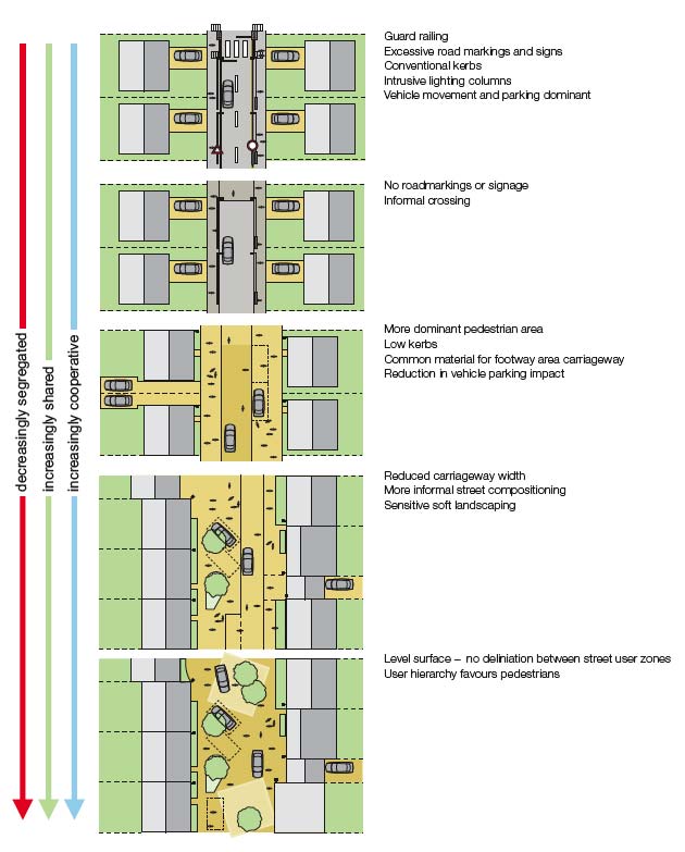
Shared Space
A Shared Space is a street or place accessible to both pedestrians and vehicles that is designed to enable pedestrians to move more freely by reducing traffic management features that tend to encourage users of vehicles to assume priority.
Achieving this reduction in dominance can be assisted by the techniques described previously and also by the minimal use of traffic signs, road markings and other traffic management features where appropriate. With less, or no, traffic management measures giving clear indications of priority, motorists are encouraged to recognise the space as being different, drive more slowly, and respond directly to the behaviour of other users (including other motorists).
Home Zones are essentially Shared Spaces, and are provided in residential areas. Home Zones can be formally designated as such under Section 74 of the Transport (Scotland) Act 2001, 14 although there is no requirement to do so. Further guidance on the design of Home Zones concept schemes is given in Home Zones; Challenging the future of our streets 15 , Home Zone Design Guidelines 16 and at www.homezones.org.uk.
Level surfaces
Some Shared Space schemes feature what is often referred to as a shared or level surface, although not all will do so. There is a variety of terminology used to describe this approach; this document will refer to the technique as a level surface. For the purposes of this guidance, a level surface is a street surface that is not physically segregated by kerb or level differences into areas for particular users. Level surfaces work best in relatively calm traffic environments.
The lack of defined areas for pedestrians and vehicles is intended to indicate that the street is meant to be shared equally by all users. Motorists are expected to adapt their behaviour to that of other street users, driving slowly and giving way as appropriate.
The key aims are to:
- encourage low vehicle speeds;
- create an environment in which pedestrians can walk, or stop and chat, without feeling intimidated by motor traffic;
- make it easier for people to move around, particularly wheelchair users and people pushing wheeled equipment such as prams; and
- promote social interaction.
In the absence of a formal carriageway, experience shows that motorists entering the area will tend to drive more cautiously and negotiate the right of way with pedestrians on a more conciliatory level.
Control of car parking needs to be considered in level surface areas. Car parking should be organised to deter cluttered streets and sufficient provision, including the provision of disabled parking spaces, should be allocated around a scheme to ensure that parking is distributed evenly and clearly.
Level surfaces are only one component of the principles of Shared Space and should not be solely relied upon to create good streets or to slow traffic.
Ensuring inclusive design
Shared Space, and level surfaces in particular, can cause problems for some disabled people. The absence of a conventional kerb in level surfaces can pose problems for some blind or partially-sighted people, who often rely on this feature to find their way around. The lack of visual cues may also pose problems for pedestrians with cognitive difficulties. It is therefore important that level surface schemes include an alternative means by which visually-impaired people can navigate. Such elements can be designed in collaboration with local people, including representatives from local disability groups and access panels. Disability groups should also be invited to provide input throughout the Quality Audit stages. Quality Audits are explained in more detail in Part 3 How to achieve better outcomes. Any design solution should be informed by local context and the local community.
Research commissioned by the Department for Transport looking into Shared Space is currently underway and is due for final publication in 2011. The first stage of the research was published in Shared Space Project Stage 1: Appraisal of Shared Space. 17 The conclusions of this report include the statement that " evidence broadly suggests that Shared Space Schemes can deliver benefits: they appear to support economic activity, improve perceptions of personal security, be popular generally with the public and traders and increase freedom of movement for many people including some vulnerable pedestrians." The report concluded that " a case can be made for level surfaces as a valid feature in some settings but that the detailed design of particular schemes needs to recognise and respond to the needs of all users."
It should be noted that this is an intermediate report and its findings will be subject to final clarification. Final outcomes of this research should be taken into account when considering Shared Space.
Research commissioned by the Disabled Persons Transport Advisory Committee ( DPTAC) on the implications of Home Zones for disabled people was published in 2007. Designing for Disabled People in Home Zones 18 contains relevant guidance.
Surface treatments
Shared Space streets are often constructed from paviours or other materials rather than asphalt, which helps emphasise their difference from conventional streets. Research for Manual for Streets shows that block paving reduces traffic speeds by between 2.5 mph and 4.5 mph, compared with speeds on asphalt surfaces. The use of block paving can also provide permeable surfaces for drainage.
Block paving may not be appropriate in all Shared Space or level surface areas, and contextual circumstances are key to decisions on materials. Coloured or textured asphalts can provide an effective delineation. Many Scottish towns and villages contain existing areas of successful level surfaces that use traditional materials or simple asphalt surfaces.
Perthshire Housing Association
Integrating parking
Key considerations
- Parking should be accommodated by a variety of means to provide flexibility and lessen visual impact
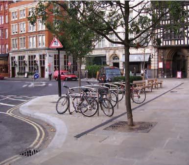
Cycle parking
Providing enough convenient and secure cycle parking at homes and other locations for both residents and visitors is critical to increasing the use of cycles. In residential developments, designers should aim to make access to cycle storage at least as convenient as access to car parking.
Reference should be made to the relevant local guidance and any relevant travel plans to determine the appropriate level of provision of cycle parking. The following key principles should, however, apply:
- Shared cycle parking facilities should be secure, overlooked and convenient to use with shelter provided wherever practical.
- Appropriate provision should be made for all potential users including children and visitors.
- Cycle parking can be provided in a number of ways such as: within garages; bespoke cycle storage; communal areas in flats; and on-street cycle racks.
- Cycle stands need to be located clear of pedestrian desire lines, and generally closer to the carriageway than to buildings.
- Cycle parking should be provided at bus and train stations to assist transition between transport modes.
- Cycle parking should be detectable by blind or partially sighted people.
Further guidance on the design of cycling facilities is provided in LTN 2/08 Cycle Infrastructure design. 19
Cycle parking that has good surveillance and is at a key location - in this example near a hospital entrance
Car parking
The Scottish Government's general planning policy for car parking is set out in the Transport section of the Scottish Planning Policy ( SPP) 20 . This makes it clear that it is important to consider a design-led approach to the provision of car parking space that is well-integrated with a high-quality public realm. A design-led and contextual strategy for car parking can often lessen the impact on the built environment. Car parking can be provided in a number of ways as set out over the following pages.
- On-street parking
On-street parking in residential streets can help to reduce traffic speeds. This kind of parking can be counted towards the overall provision required in new developments, both for residents and visitors. Parking on adopted roads cannot be allocated to individual properties, but is a common resource.
In the past, on-street parking bays have been rigidly defined, creating an artificial constraint on street layout. More informal parking arrangements are to be encouraged, such as the use of subtle widening within a street or by using end-on or angled parking within a square. Trees, planting or street furniture can be used to discourage indiscriminate parking in an attractive way. Parking violations, however, cannot be acted upon without Traffic Regulation Orders, with traffic signs and road markings to indicate the restrictions in place.
An arrangement of parking bays adjacent to the running lanes is often the preferred way of providing on-street parking. It is recommended that, in most circumstances, at least some parking demand in residential and mixed-use areas is met with well-designed on-street parking:
Breaking up the visual impact can sometimes be achieved by limiting on-street parking to small groups of around five spaces.
In deciding how much on-street parking is appropriate, it is recommended that the positive and negative effects listed in the 'On-street parking' box are considered.
Gradual widening of the carriageway to create more informal on-street spaces, with running carriageway checked using vehicle tracking
On-street parking: positive and negative effects
The positive effects of on-street parking are that it:
- provides a common resource, catering for vehicles used by residents, visitors and service providers in an efficient manner;
- is able to cater for peak demands from various users at different times of the day, for example people at work or residents;
- adds activity to the street and slows traffic;
- is typically well overlooked, providing improved security;
- is popular and likely to be well-used;
- can provide a useful buffer between pedestrians and traffic; and
- potentially allows the creation of areas within perimeter blocks that are free of cars.
The negative effects of on-street parking are that it:
- can be visually dominant within a street scene and can undermine the established character;
- may lead to footway parking unless the street is properly designed to accommodate parked vehicles;
- can be dangerous and intimidating for cyclists, due to car doors opening and cars moving in and out; and
- can impair the social and play function of shared spaces if it is overly dominant.
In most situations, it will not be necessary to provide parking spaces specifically for service vehicles, such as delivery vans, which are normally stationary for a relatively short time.
- Off-street parking
Off-street parking will be required in many developments, whether on the house plot, in rear courtyards or in underground structures. On-plot parking should be designed so that the front garden is not overly dominated by the parking space.
Off-street parking includes off-street courtyards and rear courtyards, and the key principles are that that they:
- are not car parks but places which have parking in them;
- should be overlooked by adjoining houses or by buildings entered from the parking area; and
- should normally include, at most, 10 parking spaces. If there are more spaces, the courtyard layout should be broken up.
Where spaces are allocated in shared areas, these may not be adopted and do not constitute roads under the Roads (Scotland) Act 1984. Alternative arrangements for the future maintenance of these areas will need to be found, whether by a factor or through other agencies.
Care must be taken to ensure good natural surveillance in any off-street parking areas. Vehicular accesses to any off-street parking areas will need to be taken into account within the overall street design.
Parking courts should be considered as positive places
- Basement or undercroft parking
The advantage of putting cars underground is that it preserves the street frontage, uses land more efficiently and may be more convenient for drivers accessing the building, particularly in adverse weather. However, as with courtyard parking, much depends on the location and design of the entrance. Careful consideration should be given to the visual impact of undercroft parking at street level.
Discreet undercroft parking
Karen Esslemont
- On-plot parking
Parking within the front curtilage should generally be avoided as it breaks up the frontage, can be unsightly and restricts informal surveillance. On-plot parking may be suitable in restricted situations when integrated with other parking solutions and when considered in terms of the overall street profile.
- Garages
Garages are not always used for car parking and this can create additional demand for on-street parking. Car ports are a good alternative. Dimensions for garages should be sufficient to recognise current vehicle sizes in order to encourage their use for car storage.
- Parking spaces for disabled people
It is recommended that parking bays for disabled people are designed so that drivers and passengers, either of whom may be disabled, can get in and out of the car easily. They should allow wheelchairs users to gain access from the side and the rear. The bays should be large enough to protect people from moving traffic when they cannot get in or out of their car on the footway side. Dropped kerbs should be conveniently sited to enable drivers who use wheelchairs to gain easy access to footways. Further information is contained in PAN 78 Inclusive Design.
Car Parking; What Works Where 21 provides a comprehensive toolkit for designers that gives useful advice on the most appropriate forms of car parking relevant to different types of residential development. Consideration should also be given to the Safer Parking Scheme initiative of the Association of Chief Police Officers ( ACPO) and aimed at reducing crime and the fear of crime in parking areas. PAN 77 Designing Safer Places 22 also discusses this issue.
Motorcycle parking
In planning for private residential parking, in most situations motorcycles will be able to use car parking spaces, but in some situations it will be appropriate to provide designated motorcycle parking areas. Guidance on motorcycle parking is contained in Traffic Advisory Leaflet 02/02. 23 General advice on designing streets to meet the need of motorcycles is given in the Guidelines for Motorcycling. 24 To estimate the space required for parking motorcycles, it is recommended that a 2.0 m by 0.8 m footprint is allowed per motorcycle.
Dimensions for car parking spaces and manoeuvring space
For parking parallel to the street, each vehicle will typically need an area of about 2 m wide and 6 m long.
For echelon or perpendicular parking, individual bays will need to be indicated or marked. The rectangular bay area should be sized as follows:
- Absolute minimum of 2.4 m wide by 4.8 m long
- Desirable 2.5 m wide by 5.0 m long
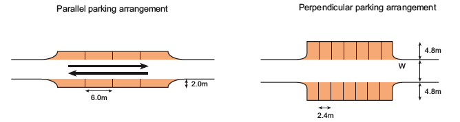
Suggested parallel and perpendicular parking arrangements
The width (W above) needed to access echelon or perpendicular spaces conveniently, depends on the width of the bay and the angle of approach. For a 2.4 m wide bay, these values are typically:
- at 90 degrees, W = 6.0 m;
- at 60 degrees, W = 4.2 m; and
- at 45 degrees, W = 3.6 m.
The width requirements can be reduced if the spaces are made wider. Swept-path analysis can be used to assess the effect of wider spaces on reducing the need for manoeuvring space, as illustrated in the diagrams below.
Where space is limited, it may not be possible to provide for vehicles to get into the spaces in one movement. Some back and fore manoeuvring may be required. This is likely to be acceptable where traffic volumes and speeds are low.
Other parking issues
Other issues for the design team and local authority to consider include:
- the appropriate level of car parking provision including the level of provision for disabled people (Blue Badge Holders);
- the negative impacts of conversion of front gardens to parking and parking in conservation areas;
- provision below normal demand (Lower levels can work successfully when adequate on-street parking controls are present and where it is possible for residents to reach day-to-day destinations, such as jobs, schools and shops, without the use of a car.);
- the potential for the use of car clubs which provide neighbourhood-based short-term car hire to members;
- unallocated parking (Not all parking spaces need to be allocated to individual properties. Unallocated parking provides a common resource for a neighbourhood or a specific development.); and
- the hazards and inconvenience to pedestrians caused by footway parking (It is therefore recommended that footway parking be minimised through the design of the street.).
The effect on overall street width requirements when wider car parking spaces are provided
Andrew Cameron WSP
Emergency and service vehicles
Key considerations
- Street layouts should accommodate emergency and service vehicles without compromising a positive sense of place
Emergency vehicles
The requirements for emergency vehicles are generally dictated by the fire service requirements. All development proposals should be discussed with the relevant Fire Authorities.
The Association of Chief Fire Officers has expanded upon and clarified these requirements as follows:
- A 3.7 m carriageway (kerb to kerb) is required for operating space at the scene of a fire. Simply to reach a fire, the access route could be reduced to 2.75 m over short distances, provided the pump appliance can get to within 45 m of all points within a dwelling.
- If an authority or developer wishes to reduce the running carriageway width to below 3.7 m, they should consult the local Fire Safety Officer.
Service vehicles
The design of streets should accommodate service vehicles without allowing their requirements to dominate the layout.
On streets with low traffic flows and speeds, it may be assumed that vehicles will be able to use the full width of the carriageway to manoeuvre. Larger vehicles which are only expected to use a street infrequently, such as pantechnicons, need not be fully accommodated - designers could assume that they will have to reverse or undertake multi-point turns to turn around for the relatively small number of times they will require access. The involvement of the local authority in determining design solutions for service vehicles is important.
Well-connected street networks have significant advantages for service vehicles. A shorter route can be used to cover a given area, and reversing may be avoided altogether.
Waste collection vehicles
It is essential that liaison between the designers, the waste, roads, planning and building control authorities, and access officers, takes place at an early stage.
Planning authorities should ensure that new developments make sufficient provision for waste management and recycling and should promote designs and layouts that secure the integration of waste management facilities without adverse impact on the street scene.
Policy for local and regional waste planning bodies is set out in Scottish Planning Policy.
Routing for waste vehicles should be determined at the concept masterplan or scheme design stage. Wherever possible, routing should be configured so that the refuse collection can be made without the need for the vehicle having to reverse, as turning areas may be obstructed by parked vehicles.
While it is always possible to design new streets to take the largest vehicle that could be manufactured, this would conflict with the desire to create quality places. It is neither necessary nor desirable to design new streets to accommodate larger waste collection vehicles than can be used within existing streets in the area.
Swept-path analysis can be used to assess layouts for accessibility. Where achieving these standards would undermine quality of place, alternative vehicle sizes and/or collection methods should be considered.
BS 5906: 2005 recommends a maximum reversing distance for refuse vehicles of 12 m. Longer distances can be considered, but any reversing routes should be straight and free from obstacles or visual obstructions.
Section 3.25 of the Scottish Building Standards (Domestic) Technical HandbooK 25 provides guidance on achieving the standards set in the Building (Scotland) Regulations 2004 26 with regard to solid waste storage and collection point. The collection point can be on-street or may be at another location defined by the waste authority. Key recommendations are that:
- residents should not be required to carry waste more than 30 m (excluding any vertical distance) to the storage point;
- waste collection vehicles should ideally be able to get to within 25 m of the storage point (although BS 5906: 2005 recommends slightly shorter distances) and the gradient between the two should not exceed 1:12; and
- there should be a maximum of three steps for waste containers up to 250 litres, and none when larger containers are used (The Health and Safety Executive recommends that, ideally, there should be no steps to negotiate).
BS 5906: 2005 27 provides guidance and recommendations on good practice. The standard advises on dealing with typical weekly waste and recommends that the distance over which containers are transported by collectors should not normally exceed 15 m for two-wheeled containers, and 10 m for four-wheeled containers.
Street detail
Drainage
Key considerations
- Streets should use appropriate SUDS techniques as relevant to the context in order to minimise environmental impacts
Street drainage
The majority of streets are designed to accommodate the disposal of foul and surface water and this needs to be considered at an early stage in the design of street layouts. This includes consideration of foul drainage, surface water and Sustainable Urban Drainage Systems ( SUDS).
Foul drainage
This will normally take the form of drains around the curtilage of buildings which come under the Building (Scotland) Regulations 2004 and sewers located in the street where the relevant guidance is found within Sewers for Scotland. 28
The adoption process for sewers is set by Section 16 of the Sewerage (Scotland) Act 1968. 29 The Scottish Water document Sewers for Scotland is a guide to facilitate the procurement, design, maintenance and adoption of sewers by Scottish Water.
Surface water drainage
The street provides a conduit for the storage or disposal of rainwater and, by its nature and its impact on the environment, the management of surface water runoff is a more complex matter than dealing with foul water. Sustainable drainage solutions adoptable by both local authorities and Scottish Water are set out in The SUDS Manual. 30 The emphasis is on the sustainable management of surface water, whereby conveyance is maintained between SUDS features in the traditional sense using pipework and open channels with SUDS features enhancing water quality, amenity and biodiversity, whilst controlling run-off quantity.
When considering the management of surface water, designers, developers and authorities need to take account of the PAN 61: Planning and Sustainable Urban Drainage, 31 Scottish Planning Policy, and the Water Environment and Water Services (Scotland) Act 2003 ( WEWS Act 2003). 32 WEWS Act 2003 transposes the Water Framework Directive 33 to assess, protect and enhance water environments in Scotland, into national law. The Water Environment (Controlled Activities) (Scotland) Regulations 2005 ( CAR)4 34 have been introduced under WEWS Act 2003 to allow regulatory controls on this matter.
The Flood Risk Management (Scotland) Act 2009 35 requires local authorities to assess and prepare maps of relevant bodies of water and SUDS which will assist in the preparation of flood risk management plans by each local authority.
Land Use Consultants
The planning and management of surface water discharge from buildings and roads requires a co-ordinated approach to evaluating flood risk and developing an integrated urban drainage strategy.
The responsibility for undertaking site specific flood risk assessments in new developments ( FRA) rests with the developer. However, Scottish Planning Policy advocates a partnership approach, consulting with the relevant stakeholders to compile the FRA. This will involve the local authority as flood authority, the Scottish Environmental Protection Agency ( SEPA) and Scottish Water.
Sewers for Scotland recommends, and some local authorities require, that drainage criteria for new development comply with the drainage assessment requirements set out in Drainage Assessment - A Guide for Scotland. 36
Sustainable Urban Drainage Systems
The term Sustainable Urban Drainage Systems covers the whole range of sustainable approaches to surface water drainage management. SUDS aim to mimic natural drainage processes and remove pollutants from urban run-off at source. SUDS comprise a wide range of techniques, including permeable paving, swales, detention basins, filter strips, filter drains, infiltration systems, bio-retention, ponds and wetlands. To realise the greatest improvement in water quality amenity and biodiversity and flood risk management, these components should be used in combination, sometimes referred to as the SUDS Management Train, as described in The SUDS Manual.
SUDS are more sustainable than conventional drainage methods because they:
- manage run-off flow rates, using infiltration and the retention of storm water;
- protect or enhance the water quality;
- are sympathetic to the environmental setting and the needs of the local community;
- provide a habitat for wildlife in urban watercourses;
- encourage natural groundwater recharge (where appropriate); and
- can assist in reduction or removal of drainage network constraints.
They do this by:
- dealing with run-off close to where the rain falls (source control);
- managing pollution at its source; and
- protecting water resources from pollution created by accidental spills or other sources.
The use of SUDS is seen as a primary objective by the Government and should be applied wherever practical and technically feasible. Granting of planning permission will be dependent on agreement between the local planning authority and SEPA, as statutory consultees. It is a SEPA requirement that sufficient levels of SUDS are provided.
New guidance, SUDS for Roads, 37 has been developed by the SUDS Working Party, including representatives of SEPA, Scottish Water and local authorities, regarding acceptable forms of SUDS to be applied to roads.
Detailed guidance on the selection and design of SUDS is contained in The SUDS Manual, Sewers for Scotland and SUDS for Roads. All stakeholders need to be aware of the importance of the application of SUDS as part of an integrated urban drainage strategy for a development.
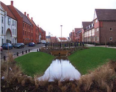
Andrew Cameron, WSP
Utilities
Key considerations
- The accommodation of services should not determine the layout of streets or footways
Utilities are an essential component of street infrastructure and can have an important effect on layout issues, such as footway widths. The accommodation of utilities must not, however, compromise the creation of a sense of place or influence the design disproportionately. It is essential to liaise with the utility companies when the layouts of the buildings and streets are being designed.
Service strips should be designed to accommodate the services contained rather than by the application of rigid standards.
The availability and location of existing services should be identified at the outset. Where possible, all utility apparatus should be laid in 'corridors' throughout the site. This will facilitate the installation of the services and any future connections as the development proceeds.
Most residential streets provide routes for statutory undertakers and other services. Detailed advice on providing for utilities in new developments can be found in NJUG Guidance 38 and local authority guidelines.
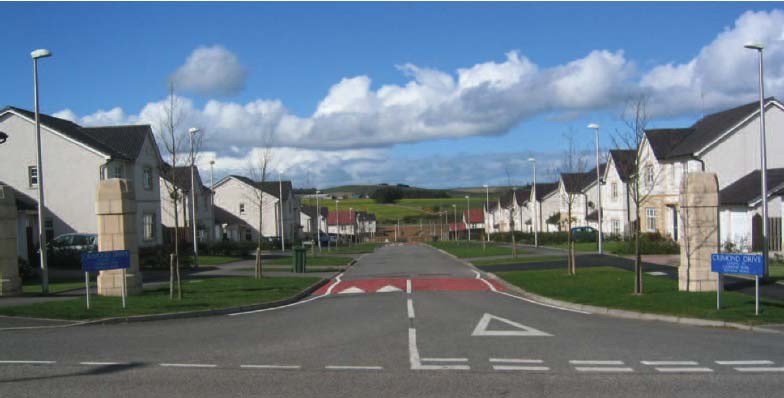
An image of a layout driven by standards and formulaic solutions - the use of large radius bends, overly-dominant lighting columns, large building setbacks, inefficient land use, and inappropriate traffic calming contribute nothing to a positive sense of place
Planting
Key considerations
- Street design should aim to integrate natural landscape features and foster positive biodiversity
Intelligent and appropriate planting in street design is encouraged. Planting, particularly street trees, helps to soften the street scene while creating visual interest, improving microclimate and providing valuable habitats for wildlife. Whilst appropriate driver sightlines should be maintained, vegetation can be used to limit excessive forward visibility to limit traffic speeds.
Care should be taken to preserve existing trees, particularly when changes to a street are planned. Consideration should also be given to the relationship of streets to existing and new green networks. Green networks can often provide pedestrian or cycle routes that offer increased connectivity and add a distinctive character area for people to enjoy.
Careful consideration needs to be given to appropriate tree selection, their location and how they are planted. Detailed advice on this issue is contained in the Communities and Local Government document, Tree Roots in the Built Environment. 39
If possible, semi-mature trees should be planted. Slow-growing species with narrow trunks and canopies above 2 m should be considered.
Maintenance arrangements for all planted areas need to be established at an early stage, as they affect the design, including the choice of species and their locations. The approval and maintenance of proposed planting within the street boundary will be required to comply with Sections 50 and 51 of the Roads (Scotland) Act 1984. 40
Alternatives to formal adoption may require innovative arrangements to secure long-term management of planting. These may include the careful design of ownership boundaries, the use of covenants and annual service charges on new properties.
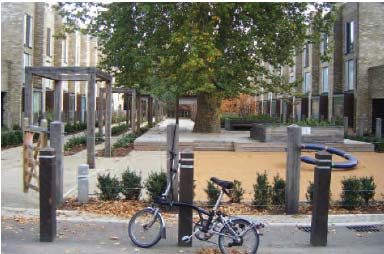
Karen Esslemont EDAW
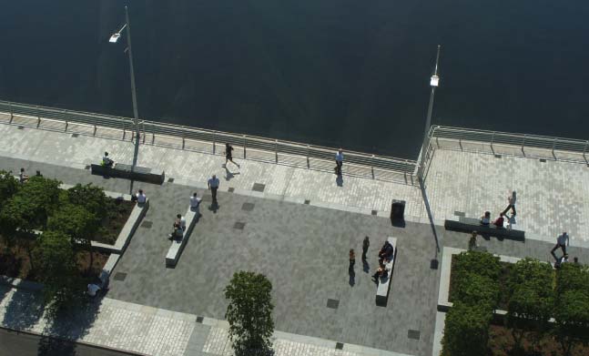
Atkins
Materials
Key considerations
- Materials should be distinctive, easily maintained, provide durability and be of a standard and quality to appeal visually within the specific context
Materials and construction
Places need to look good and work well in the long term. Design costs are only a small percentage of the overall costs, but it is the quality of the design that makes the difference in creating places that will stand the test of time. Well-designed places last longer and are easier to maintain, thus the costs of the design element are repaid over time. The specification for materials and maintenance regimes should be written to provide high standards of durability and environmental performance. Maintenance should be straightforward and management regimes should ensure that there are clear lines of responsibility. The long term success of places can be as dependent on visual appeal as durability. The quality of the design and its appropriateness to an area can have a significant effect on the extent to which a place is liked and well-used.
Local authorities should be prepared to allow the use of alternative materials, landscaping treatments and features to those normally approved if they will help to create a positive sense of place and enhance context.
It is recommended that all materials:
- are easy to maintain;
- are safe for purpose;
- are durable;
- are sustainable (including the manufacturing process and energy use);
- are appropriate to the context; and
- provide clear street definition and hierarchy.
Arrangements for future maintenance
It is important that decisions on the future maintenance arrangements of the streets and public spaces in a development are made early in the design process. If the streets are to be adopted by the local roads authority, the layout and material choices must be acceptable to the authority.
It is possible for streets to remain private but, ideally, a properly-constituted body with defined legal responsibilities will need to be established to maintain the streets to the common benefit of residents.
A road authority will require legal certainty that the streets are going to be properly maintained in perpetuity by these private arrangements. Approval for construction of new private streets will be required under Sections 17 and/or 21 of the Roads (Scotland) Act 1984 and, under Section 13 of this Act, the local roads authority has powers to require a private road is maintained to a reasonable standard (as set by the authority).
A roads authority may be unwilling to adopt items such as planting and street furniture (e.g. play equipment and public art) which are not considered to relate to the movement functions of the street. If there is no private management company, arrangements can be made for such features to be maintained by another local authority department.
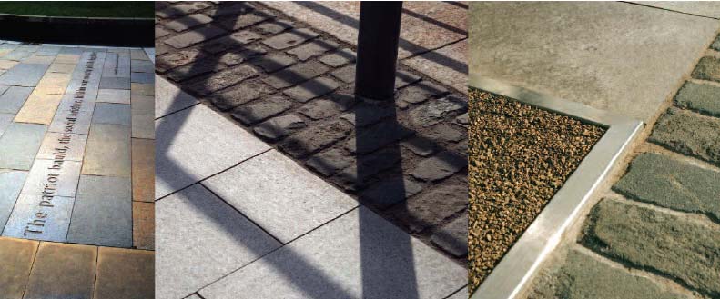
Gillespies and Paul Zanre
Reducing clutter
Key considerations
- Signs and street markings should be kept to a minimum and considered early in the design process
- Street lighting should be as discreet as possible, but provide adequate illumination
- Street furniture should be located for maximum benefit and to reduce pedestrian obstruction
Traffic signs
The Traffic Signs Regulations and General Directions 2002 41 ( TSRGD ), is a regulatory document which details every traffic sign prescribed for use in the UK. It includes all of the prescribed road markings, as a road marking is legally a sign. TSRGD also stipulates the conditions under which each sign may be used.
Further advice on the use of signs is contained in the Traffic Signs Manual, 42 which gives advice on the application of traffic signs in common situations. Compliance with TSRGD is mandatory. The Traffic Signs Manual is guidance and there is therefore scope for moving away from its recommendations if justified by local circumstances.
The requirement for signs
No sign is fundamentally required by TSRGD per se. Signs are only needed to warn or inform, or to give effect to Traffic Regulation Orders ( TROs) and TSRGD simply sets out how signs must be used once it has been decided that they are necessary.
Signs are most effective when used sparingly. Designers should ensure that each sign is necessary - they should use the flexibility within the TSRGD and associated guidance documents to ensure that signs are provided as required, but do not dominate the visual appearance of streets.
The non-provision of signs and markings may be appropriate in lightly-trafficked environments specifically designed to promote low speeds. It reduces clutter and the relative lack of signage may also itself encourage lower vehicle speeds.
Signs which have no clear purpose should be removed to reduce clutter and to ensure that essential messages are prominent. Although much signage is provided for the benefit of motorised users, it is generally located on the footway and can contribute to clutter.
In the case of new developments, some road authorities seek to guard against having to install additional signs at their own expense later, by requiring all manner of signs to be provided by the developer at the outset. This will lead to clutter and is not recommended. The preferred way of addressing such concerns is to issue a bond to cover an agreed period, so that additional signs, if deemed absolutely necessary, can be installed later at the developer's expense if required.
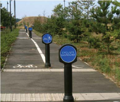
Innapropriate signage
John Thompson & Partners
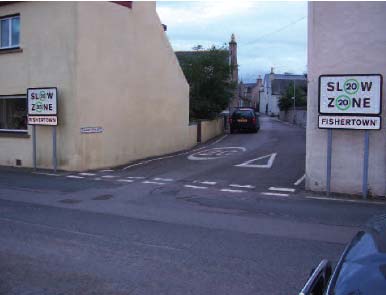
Overly dominant signage that detracts from the place
Andrew Cameron WSP
It is desirable to limit the number of posts in footways. Where possible, signs should be attached to adjacent walls, not more than 2 m from the edge of the carriageway, or be grouped on posts.
Existing streets should be subject to a signs audit to ensure that they are not over-signed and, in particular, that old, redundant signs have been removed.
The use of centre lines is not an absolute requirement. There is some evidence that, in appropriate circumstances, the absence of white lines can encourage drivers to drive at lower speeds.
Most unsignalised junctions are designed assuming a dominant flow, with priority indicated by give-way signs and markings. There is no statutory requirement for junction priority to be specified. Unmarked junctions that require drivers to 'negotiate' their way through may be appropriate on lower volume streets, as this can help to control speeds.
Street furniture
Every piece of street furniture should earn its place in the street.
Street furniture should have a clear function and should not be regarded as simple ornamentation. Street furniture should be integrated into the overall design of a street and relate to context.
Street furniture that encourages human activity can also contribute to a sense of place. The most obvious example of this is seating, or features that can act as secondary seating such as low walls or planters. Wherever possible, street furniture should perform more than one function in the interests of reducing clutter and improving amenity.
Seating is necessary to provide rest points for pedestrians, particularly older people or people with mobility or visual impairments, and extra seating should be considered where people congregate, such as squares, local shops and schools. Guidance is given in PAN 78 Inclusive Design and BS 8300. 43 Seating can sometimes attract anti-social behaviour and therefore should be located where there is good lighting and natural surveillance.
Guard railing
Guard railing should not be provided unless a clear need for it has been identified. Introducing measures to reduce traffic flows and speeds may be helpful in removing the need for guard railing. In most cases, it is unlikely that guard railing will be required on residential streets.
As well as being visually intrusive, the inappropriate use of guard railings can block pedestrian desire lines, with consequential possible dangers
Andrew Cameron WSP
Lighting
Where streets are to be lit, lighting should be planned as an integral part of the design of the street layout at an early stage. Lighting should illuminate both the carriageway and the footway.
Consideration should be given to attaching lighting units to buildings to reduce street clutter. Under Section 35 (5) of the Roads (Scotland) Act, local authorities have the power to fix lighting to walls and buildings, subject to a statutory consultation with involved parties and a specified notice period.
Lighting should be appropriate and sympathetic to the context. A street lighting assessment can be helpful in determining both the level of lighting and the type of equipment used in the area.
In street design, consideration should be given to the purpose of lighting, the scale of lighting relative to human users of the street, the width of the street and the height of surrounding buildings.
Where road and pedestrian area lighting are both required, some road authorities install lamp columns featuring a secondary footway light mounted at a lower height. This can assist in illuminating pedestrian areas well, particularly where footways are wide or shaded by trees.
The colour of lighting is another important consideration. This relates both to people's ability to discern colour under artificial light and the colour 'temperature' of the light. Light colour temperature is a consequence of the composition of the light, ranging simply from blue (cold) to red (warm). Generally, pedestrians prefer whiter lighting.
Lighting should generally be in accordance with BS EN 13201-2, 44 BS EN 13201-3, 45 and BS EN 13201-4. 46 Guidance on lighting design is given in BS 5489-1, Code of Practice for the Design of Road Lighting, 47 to comply with the requirements of BS EN 13201. This is a guidance document only and local circumstances may require different approaches.
Further guidance is contained within Controlling Light Pollution and Reducing Lighting Energy Consumption, 48 PAN 51: Planning, Environmental Protection and Regulation 49 and PAN 77: Designing Safer Places.
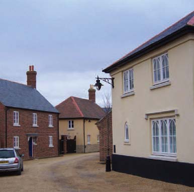
Building-mounted lighting
Andrew Cameron WSP