Marine and freshwater: areas of research interest
This document articulates the Areas of Research Interest (ARI) for Marine and Freshwater. Resulting knowledge and innovation will support evidence-based policy development towards delivering Scotland’s Blue Economy Vision and addressing climate change and biodiversity crises.
Introduction
Scotland's Blue Economy Vision encapsulates our increasing awareness of the importance
of the marine and inter-linked freshwater and coastal environments. This document builds on that importance and the potential for marine and freshwater (henceforth, we use ‘marine’ to include freshwater habitats of anadromous fishes, e.g. salmon) resources to support sustainable prosperity by gathering those ideas into coherent Areas of Research Interest (ARIs).
ARIs are statements of which areas of research are most important to government for policy making and aims to improve the evidence base for policymaking by fostering dialogue
between policymakers and academia. ARIs are designed to encourage academia to contribute to addressing key policy questions. They are generally owned by Chief Scientific Advisers. ARIs are not government commitments to undertake or fund research, rather they are statements of research need.
Scotland's Marine and Freshwater Context
Scotland's marine area is vast, covering over 462,000 km², and includes some of the most productive and diverse marine ecosystems in Europe. Our coastal waters, territorial seas, and Exclusive Economic Zone contain a wealth of habitats and species, support vital economic activities, and play a significant role in Scotland's cultural identity and heritage.
Scotland’s marine economy includes activities dependent on the marine environment. They provide an important source of income and employment across Scotland. Some key points are:
- In 2022, the marine economy generated £4.9 billion in approximate Gross Value Added (aGVA), 3% of the overall Scottish economy.
- In 2022, the marine economy employed 71,000 people (headcount), 2.7% of the total Scottish employment.
- Between 2021 and 2022, the marine economy’s aGVA increased by 7%.
Scotland's freshwater systems include some 125,000 km of rivers and streams, and over 31,000 freshwater lochs. These freshwater environments support biodiversity, generate renewable energy, and offer recreational opportunities that enhance wellbeing and support tourism.
Together, these environments face significant challenges from climate change, biodiversity loss, competing demands for space and resources, and historic environmental degradation.
They also present substantial opportunities for sustainable economic development, community regeneration, and ecosystem restoration.
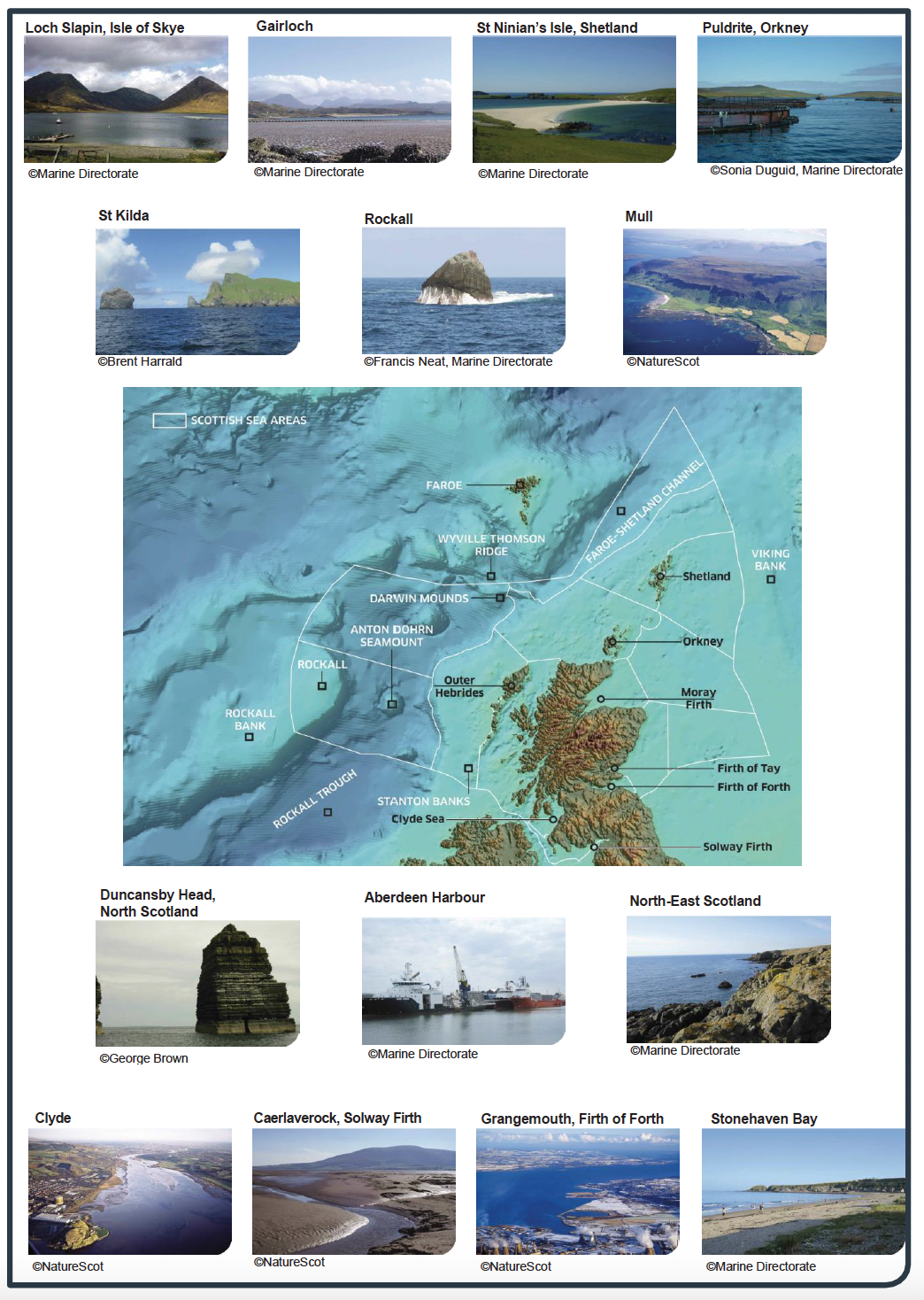
Figure 1 plain text version:
This figure displays a collection of photographs showcasing Scotland's diverse marine and freshwater environments and a detailed bathymetric map of Scottish waters. The top section features seven photographs of key Scottish marine locations:
Loch Slapin, Isle of Skye: A dramatic loch surrounded by mountainous terrain, credited to Marine Directorate.
Gairloch: Coastal waters with sandy beaches and clear blue seas, credited to Marine Directorate.
St Ninian's Isle, Shetland: A distinctive tombolo connecting the small island to the mainland, showing pristine sandy beaches, credited to Marine Directorate.
Puldrite, Orkney: A marine fish farm located in a waters typical of Orkney's marine environment, credited to Sonia Duguid, Marine Directorate.
St Kilda: Remote island group showing dramatic sea cliffs and seabird colonies, credited to Brent Harrald.
Rockall: The isolated rocky outcrop in the North Atlantic, showing rough seas around the distinctive pyramidal rock formation, credited to Francis Neat, Marine Directorate.
Mull: Aerial view of the island's varied coastline and surrounding waters, credited to NatureScot.
The central portion displays a comprehensive bathymetric map of Scottish waters showing:
- The Wyville-Thomson Ridge and Faroe-Shetland Channel in the far north
- Darwin Mounds and Anton Dohrn Seamount in the deep waters west of Scotland
- The Rockall Trough and Stanton Banks
- Major firths including the Moray Firth, Firth of Tay, Firth of Forth, and Solway Firth
- The Outer Hebrides and Shetland islands
- Depth variations shown through blue shading, with deeper waters appearing darker
The lower section features four additional photographs:
Duncansby Head, North Scotland: Dramatic coastal stacks and cliffs at Scotland's northeastern extremity, credited to George Brown.
Aberdeen Harbour: Commercial shipping activity showing Scotland's important maritime infrastructure, credited to Marine Directorate.
North-East Scotland: Rocky coastline typical of the region, credited to Marine Directorate.
Clyde: The river estuary and surrounding landscape, credited to NatureScot.
Caerlaverock, Solway Firth: Wetland and coastal environment, credited to NatureScot.
Grangemouth, Firth of Forth: Industrial and port facilities, credited to NatureScot.
Stonehaven Bay: Coastal bay environment, credited to Marine Directorate.
Purpose of this document
This ARI document sets out the key research questions that will help the Scottish Government deliver its Blue Economy Vision and develop evidence-based policies for the sustainable management of Scotland's marine and freshwater environments. It aims to:
- Articulate the Scottish Government's medium to long-term evidence needs for marine and freshwater policy development and decision-making.
- Promote collaboration, partnerships, and engagement with relevant academic and industry experts.
- Encourage research that addresses critical knowledge gaps and informs policy development, whilst recognising the trade-offs inherent in balancing protection, sustainable use and economic development
ARIs are a mechanism for government to communicate its research interests to the academic community, research funders, industry, commerce and other stakeholders. This document will be used to guide research commissioning, inform strategic research partnerships, and encourage external researchers to engage with policy-relevant questions.
Land-sea interactions
Whilst our focus is on the aquatic, the health of marine and freshwater environments is intimately connected to activities on land. Research is needed to understand these connections and develop integrated approaches to management across the land-sea interface.
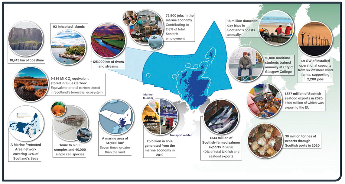
Figure 2 plain text version:
This infographic illustrates the significant economic, environmental, and social value of Scotland's marine and freshwater systems. The central feature is a stylised map of Scotland showing the marine environment in various shades of blue, surrounded by circular images and statistical information highlighting key aspects of Scotland's marine economy and environment.
Geographic Features:
- 18,743 km of coastline
- 93 inhabited islands
- 125,000 km of rivers and streams
- A marine area of 617,000 km² - seven times greater than the land
Environmental Assets:
- 9.636 Mt CO₂ equivalent stored in 'Blue Carbon' - equivalent to total carbon stored in Scotland's terrestrial ecosystem
- A Marine Protected Area network covering 37% of Scotland's seas
- Home to 6,500 complex and 40,000 single cell species
Economic Contributions:
- 75,500 jobs in the marine economy, contributing to 2.8% of total Scottish employment
- £5 billion in GVA generated from the marine economy in 2019
- £614 million of Scottish farmed salmon exports in 2020 - 40% of total UK fish and seafood exports
- £877 million of Scottish seafood exports in 2020, £709 million of which was export to the EU
- 30 million tonnes of exports through Scottish ports in 2020
- 1.9 GW of installed operational capacity from six offshore wind farms, supporting 2,200 jobs
- 10,000 maritime students trained annually at City of Glasgow College
Tourism and Recreation:
- 16 million domestic day trips to Scotland's coasts annually
The surrounding photographs showcase diverse marine environments including coastal cliffs, beaches, marine wildlife, fishing activities, offshore installations, and renewable energy infrastructure, demonstrating the multifaceted nature of Scotland's relationship with its marine environment. This visual representation emphasises how Scotland's extensive marine territory provides significant economic, environmental, and social benefits that far exceed what might be expected relative to the country's terrestrial area.
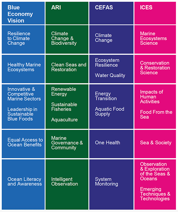
Figure 3 plain text version:
This matrix demonstrates the alignment between Scotland's Blue Economy Vision, with this Area of Research and against CEFAS and ICES frameworks. The table is organised into four main columns representing different organisational approaches:
Column 1 - Blue Economy Vision (Light Blue):
- Resilience to Climate Change
- Healthy Marine Ecosystems
- Innovative & Competitive Marine Sectors
- Leadership in Sustainable Blue Foods
- Equal Access to Ocean Benefits
- Ocean Literacy and Awareness
Column 2 - ARI (Green):
- Climate Change & Biodiversity
- Clean Seas and Restoration
- Renewable Energy
- Sustainable Fisheries
- Aquaculture
- Marine Governance & Community
- Intelligent Observation
Column 3 - CEFAS (Dark Blue):
- Climate Change
- Ecosystem Resilience
- Water Quality
- Energy Transition
- Aquatic Food Supply
- One Health
- System Monitoring
Column 4 - ICES (Pink):
- Marine Ecosystems Science
- Conservation & Restoration Science
- Impacts of Human Activities
- Food From the Sea
- Sea & Society
- Observation & Exploration of the Seas & Oceans
- Emerging Techniques & Technologies
The horizontal alignment of themes across the four columns demonstrates how Scotland's domestic priorities (Blue Economy and ARI) align with the scientific frameworks of CEFAS (Centre for Environment, Fisheries and Aquaculture Science) and ICES (International Council for the Exploration of the Sea). This matrix illustrates that Scotland's marine strategy is developed within and contributes to broader international scientific frameworks, ensuring consistency and enabling collaborative approaches to marine management and research.
Structuring of ARIs
There are many ways to categorise ARIs, none of which is perfect in the sense that a single research area may service many needs, and a single need may require evidence from many areas. A number of existing structural entities serve as a guide: The Scottish Government’s Blue Economy Vision sets out six Outcomes, which are consistent with the UK Marine Policy on “a marine environment, which is clean, healthy, safe, productive and biologically diverse, managed to meet the long-term needs of nature and people”; The UK Marine Strategy has eleven Good Environmental Status (GES) qualitive descriptors, reported on through four DEFRA working groups; MCCIP (Marine Climate Change Impacts Partnership) , focusing on climate change, identifies three impact areas; CEFAS has seven Science Themes , as does the science plan of the International Council for the Exploration for the Seas (ICES) . All these approaches have commonalities; here we have identified seven ARI themes and we demonstrate how they relate to the Blue Economy Vision outcomes and to CEFAS and ICES Science Themes (Figure 3). Figure 4 sets our seven identified ARI themes in the context of legislated government commitments, which are elaborated on in Appendix A.
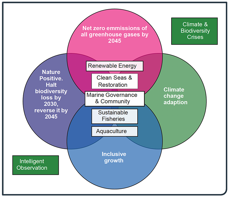
Figure 4 plain text version:
This Venn diagram illustrates how Scotland's Areas of Research Interest (ARIs) align with primary legislative frameworks. The diagram features four overlapping circles representing different policy domains:
Main Policy Circles:
- Net zero emissions of all greenhouse gases by 2045 (large pink circle, top)
- Nature Positive: Halt biodiversity loss by 2030, reverse it by 2045 (blue circle, left)
- Climate change Adaptation (green circle, right)
- Inclusive growth (blue circle, bottom)
The central overlapping area contains the key ARI themes:
- Renewable Energy
- Clean Seas & Restoration
- Marine Governance & Community
- Sustainable Fisheries
- Aquaculture
Two additional green boxes positioned outside the circles highlight cross-cutting considerations:
- Climate & Biodiversity Crises (top right)
- Intelligent Observation (bottom left)
This diagram demonstrates how the ARIs are designed to contribute simultaneously to multiple national policy objectives, ensuring that marine initiatives support climate targets, biodiversity conservation, economic growth, and adaptive capacity in an integrated manner. The overlapping nature of the circles emphasises that these policy domains are interconnected rather than separate, requiring coordinated approaches to achieve multiple benefits.
Cross cutting themes
Three of the ARI themes cut across four specific research area themes; Figure 5 illustrates the interconnected structure of Scotland's seven marine and freshwater ARI themes, providing an integrating framework. We now introduce the cross-cutting themes and specific research area themes, before fully expanding the science questions raised within each.
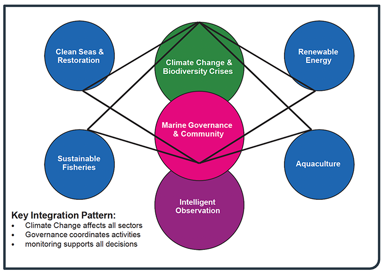
Figure 5 plain text version:
This diagram illustrates the complex relationships and interconnections between key marine themes. The design features a central pink circle representing "Marine Governance & Community" surrounded by six blue circles and additional connecting elements.
The six main theme areas arranged around the central governance hub are:
- Clean Seas & Restoration (top left)
- Renewable Energy (top right)
- Sustainable Fisheries (middle left)
- Aquaculture (middle right)
Two additional critical elements are positioned vertically:
- Climate Change & Biodiversity Crises (top, in green)
- Intelligent Observation (bottom, in purple)
The diagram uses connecting lines to show relationships between all elements, emphasising three key integration patterns identified in the legend:
- Climate Change affects all sectors
- Governance coordinates activities
- Monitoring supports all decisions
This visual representation emphasises that marine governance and community engagement sit at the heart of coordinating diverse marine activities, whilst climate change and biodiversity considerations overarch all themes, and intelligent observation provides the evidence base for informed decision-making across all sectors.
Climate and biodiversity crises
Scotland is facing the interlinked crises of climate change and biodiversity loss, which are central to the Scottish Government’s priority of addressing the climate emergency and provide an overarching context for our ARIs. Scotland’s Marine Assessment 2020 (SMA2020) highlights significant climate-related impacts on marine and freshwater environments, including:
- Ocean warming, sea level rise, and acidification
- Shifts in biodiversity and species distribution
- Changes in plankton communities, with cascading effects on marine food webs (e.g., marine mammals, seabirds, and commercial fish species)
Coastal habitats—such as beaches, dunes, saltmarshes, and machair—are under increasing pressure from rising sea levels and more frequent storm surges, leading to erosion and habitat fragmentation. These habitats are vital for coastal resilience and support resident and migratory waterbirds.
The intensification of human activities in marine and freshwater environments is increasing competition for space and resources. Key pressures include:
- Seabed disturbance from bottom-contact towed fishing gear, particularly affecting subtidal biogenic habitats
- Cumulative impacts from multiple activities (see figure 6)
Research is needed to support marine spatial planning, assess cumulative impacts, and develop strategies for the co-existence of diverse marine uses.
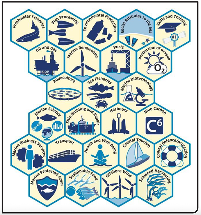
Figure 6 plain text version:
This diagram presents a comprehensive overview of the diverse range of activities and sectors that utilise Scotland's marine environment. The illustration uses a hexagonal grid pattern with 25 distinct categories, each represented by a blue icon and descriptive text.
Freshwater Fisheries: Represented by a leaping salmon icon
Fish Processing: Shown with stylised processed fish
Environmental Protection: Depicted with stylised depictions of marine litter
Social Attitudes to the Sea: Illustrated with stylised depictions of flippers and starfish on a beach
Skills and Training: Represented by a graduation cap and academic certificate scroll
Oil and Gas: Shown with an offshore drilling platform
Marine Renewables: Depicted with a wind turbine symbol
Ports: Illustrated with port infrastructure including cranes
Production of Oxygen: Represented by the chemical symbol O₂
Aquaculture: Shown with circular fish farming installations
Sea Fisheries: Depicted with fish and marine life symbols
Marine Biotechnology: Illustrated with laboratory equipment and microscope
Marine Science: Shown with a chart, fish and globe symbols
Ship Building and Repair: Depicted with vessels and construction equipment
Harbours: Represented by harbour infrastructure
Blue Carbon: Shown with "C6" chemical notation
Marine Business Services: Illustrated with business and human figures
Transport: Depicted with a shipping vessel symbol
Health and Well-Being: Shown with a person sitting in a meditation position symbol
Coastal Tourism: Illustrated with recreational sailing boats
Coastal Defence/Protection: Represented by life ring symbol
Marine Protected Areas: Shown with conservation shield symbol with a fish in the centre
Sustainable Food: Depicted with sustainable marine food symbols
Offshore Wind: Illustrated with offshore wind turbine arrays
Seaweed Harvesting: Shown with seaweed collection symbols
This overview demonstrates the complexity and interconnectedness of Scotland's marine economy, highlighting how the marine environment supports traditional industries like fishing and shipping alongside emerging sectors such as marine renewables, biotechnology, and blue carbon initiatives.
Marine governance and community engagement
At the centre of Scotland’s marine and freshwater ARI framework is the need for effective governance (Figure 4). Marine Governance & Community provides a coordination mechanism.
This includes:
- Translating climate and biodiversity imperatives into actionable policies
- Engaging stakeholders in decision-making
- Supporting evidence-based governance aligned with Scotland’s Blue Economy vision
Understanding the social and economic dimensions of marine and freshwater management is essential for developing policies that are fair, equitable, and effective. Research is needed to assess the distribution of benefits and costs, understand behavioural drivers, and develop approaches that support just transitions.
Specific research areas
Four sector-specific research themes (Figures 3 and 4) represent the primary domains where research questions and findings can be applied to real-world challenges.
- Renewable Energy
- Clean Seas & Restoration
- Sustainable Fisheries
- Aquaculture
Each area addresses specific challenges while contributing to broader environmental, economic, and social goals.
Intelligent observation and data systems
Supporting the entire ARI structure is Intelligent Observation. Effective marine and freshwater management requires robust data and evidence. Research is needed to develop integrated monitoring systems, harness new technologies, and ensure that data is accessible, interoperable, and useful for decision-making. Research priorities include:
- Developing interoperable and accessible data systems
- Harnessing new technologies for real-time observation
- Building a strong evidence base for adaptive management
The connecting lines in Figure 5 emphasise that while each theme has distinct research questions, they operate as an integrated system where advances in one area informs and strengthen others. This reflects the underlying principles of Scotland's Blue Economy
Vision with regards to marine stewardship, where environmental management, economic development, and social considerations are balanced through evidence-based governance, underpinned by monitoring systems and guided by the urgent need to address climate change and restore biodiversity.
Translating research in to policy
ARIs create a mechanism lying between knowledge creation and practical application, enabling research outputs to align with policy and industry decision-making processes. ARIs provide an articulation of government evidence requirements, providing researchers with strategic direction for their work, where that is desired. This approach provides a platform for knowledge exchange by creating common language and priorities between researchers and policy makers, making research findings more accessible and applicable to those
who implement policies or make business decisions. When combined with collaborative governance frameworks, ARIs establish feedback mechanisms where research has a route in to policy implementation. The transparency provided by ARIs also helps funders wishing to target investments toward policy-impact research areas, while giving researchers confidence that their work addresses societal needs, ultimately accelerating the translation of scientific insights into tangible environmental, economic, and social benefits for marine and freshwater environments.
Relationship to legislative and strategic frameworks
Relevant UK and Scottish legislation and Scottish, UK and international strategic frameworks (explained in Appendix A) create a comprehensive, if complex, approach to marine and freshwater governance that addresses three key priorities: driving sustainable economic growth, enhancing environmental protection, and building resilience and strengthening capacity in marine, freshwater and coastal management.
A note on nature-based solutions and natural capital
Nature-based solutions (NbS) are approaches that work with and enhance natural ecosystems to address societal challenges — especially climate change and biodiversity loss—while providing benefits for people and nature. Nature-based approaches are often considered to be better than purely engineered solutions in many contexts—not because they replace engineering entirely, but because they offer multiple co-benefits, greater sustainability, and long-term resilience.
The transformation toward nature-positive management, seeking to halt and reverse nature loss by 2030 and restore and regenerate by 2045 requires the adoption at scale of NbS.
This means going beyond protecting what remains to actively restoring marine ecosystems at scale, enhancing their capacity to address societal challenges while delivering net gains for biodiversity. The aim is systemic change that rebuilds marine ecosystem function and resilience. This requires developing beyond small-scale initiatives to wide-scale interventions that can meaningfully enhance ecosystem service provision and biodiversity at a sea-basin level.
Understanding and valuing Scotland's marine natural capital is fundamental to this transformation. Sophisticated frameworks are needed that capture the economic value of our seas including ecosystem services, especially climate regulating services, and their
contribution to climate resilience, food security, coastal protection and cultural identity. To do this an evidence base is needed which links the ecosystem state to service provision,
understanding connectivity and cumulative impacts, and quantifying both the costs of degradation and the benefits of recovery. By understanding these relationships, it will enable informed decisions about marine use that optimises outcomes across environmental, social and economic dimensions while ensuring genuine nature recovery.
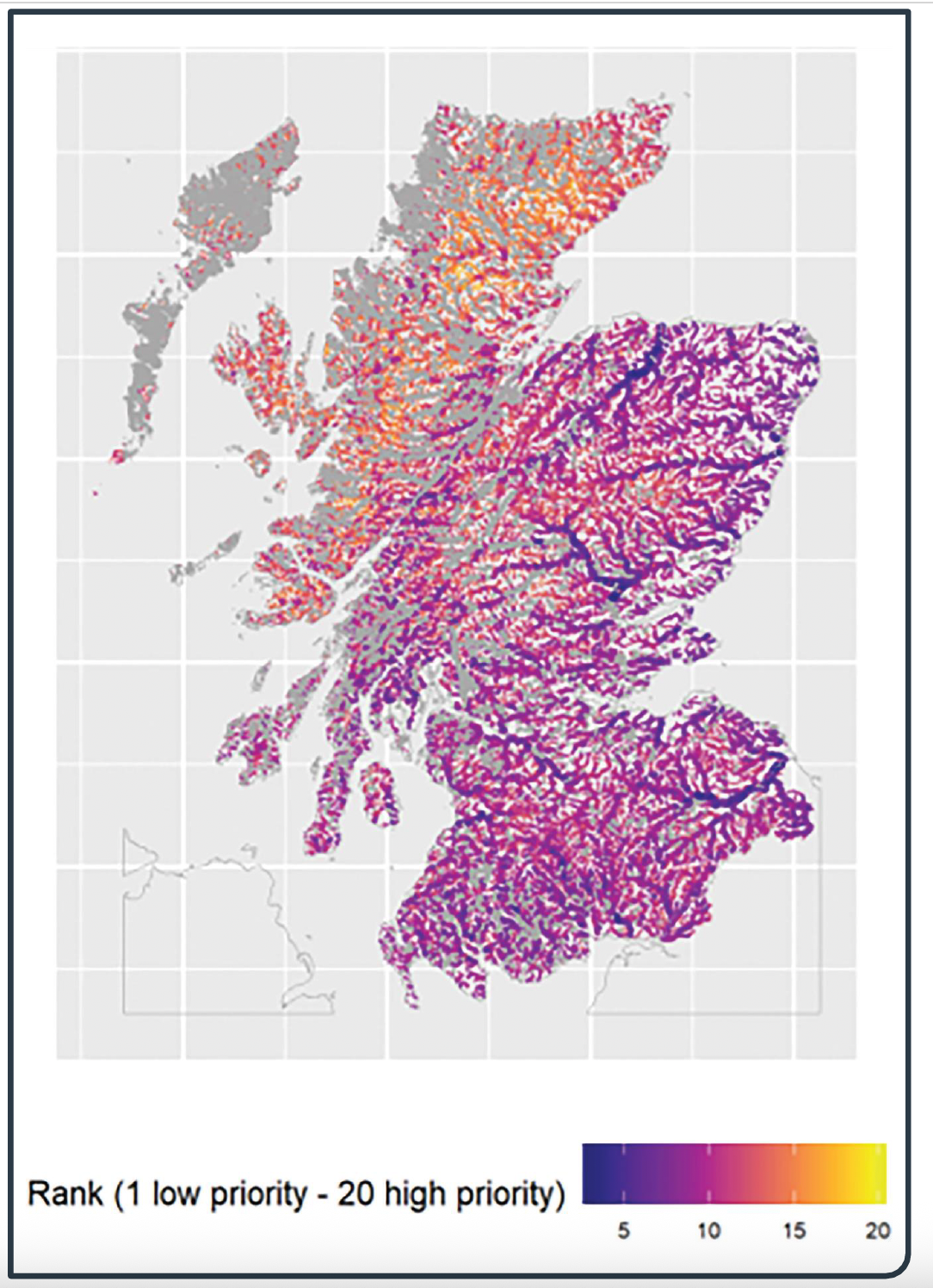
Figure 7 plain text version:
This map illustrates an example of nature-based solutions, specifically showing national riparian woodland prioritisation scores assuming trees are planted on both riverbanks throughout Scotland. The map uses a colour-coded ranking system from 1 (low priority) to 20 (high priority).
The colour scheme progresses from:
- Dark blue indicating rank 1 (lowest priority areas)
- Purple and pink representing middle-range priorities (ranks 5-15)
- Orange and yellow representing the highest priorities (ranks 15-20)
The map reveals that the highest priority areas (shown in orange and yellow) are concentrated in:
- The northwestern Highlands, particularly around Sutherland and Caithness
- Parts of the central Highlands
- Some areas in the southern Uplands
Lower priority areas (shown in darker blues and purples) are primarily located in:
- The central belt between Edinburgh and Glasgow
- Much of the eastern coastline
This prioritisation system helps identify where riparian woodland planting would provide the greatest environmental benefits.
Contact
Email: arimarinefw@gov.scot