Sandeel fishing: consultation
We are consulting on proposals to close fishing for sandeel in all Scottish waters. This paper explains the background of the consultation, options considered, and outlining the questions for respondents.
3. Current sandeel management
Sandeel is a jointly managed stock between the UK and the EU (European Union). Under the UK/EU trade and cooperation agreement (TCA), the UK has a 2.97% share and the EU a 97.03% share of the parties' combined sandeel quota in 2023. Additionally, the Total Allowable Catch (TAC) is set during in-year annual consultations, following the publication of ICES advice . As a result of the negotiations this year, the TAC has been set at 194,367 tonnes[9] which is 3% lower for areas 1r and 4[10] (UK waters) than the ICES advice.
Under the TCA and during a transition period lasting until 30 June 2026, the UK and the EU have full mutual access to their respective exclusive economic zones (EEZs) (i.e. waters adjacent from 12 – 200 nautical miles); as well as access to specific English, Welsh and Channel Island waters in the 6-12 nautical mile area. Sandeel is an important fishery to some EU member states, in particular Denmark, who regularly fish the stock in UK waters in May and June.
3.1 Sandeel fishery in UK waters and UK quota allocation
Sandeel fishing in UK waters is currently assessed and managed in the North Sea, where it supports one of the largest single-species industrial fishery. The fishery is highly seasonal, taking place mostly in the spring and summer of each year.
Sandeel are targeted by highly specific gears and are processed for their oil and fish meal for use in many types of food for human and animal consumption. Denmark, Norway, Sweden, the UK, and Germany historically participate in the sandeel fishery.
However, it remains an over-arching and long-held Scottish Government position not to support fishing for sandeel in Scottish waters, which is reflected in Scotland's Future Fisheries Management Strategy. As such, since 2021 sandeel quota has not been allocated to UK vessels.
Historically, the stock has been targeted (primarily) by one UK vessel. A major sandeel fishing area in the North Sea has also been closed to UK and EU vessels since 2000, except for a limited monitoring fishery in some years. The total landings by all UK vessels between 2016-2022 are presented in the Table 1.
| Year | 2016* | 2017 | 2018 | 2019 | 2020 | 2021* | 2022* |
|---|---|---|---|---|---|---|---|
| Sandeel catch (tonnes) | 20.9 | 3,330.8 | 1,863.2 | 1,068.5 | 3,901.4 | 3.7 | 3.1 |
*Monitoring fishery
3.2 Current area closure for sandeel
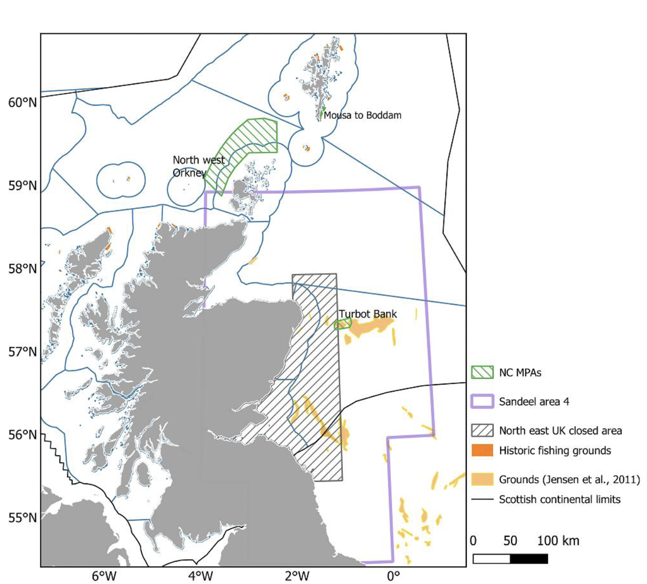
There is a sandeel closure currently in place in sandeel management area 4 (Figure 1). This area extends along most of the east coast of Scotland, as well as some of the northeast coast of England, and is exclusively within UK waters. Figure 1 also shows three Nature Conservation Marine Protected Areas (NC MPAs), which are the 'Turbot Bank', 'North west Orkney' and 'Mousa to Boddam'.
The fishery closure of an area to protect sandeel in ICES divisions 4a and 4b was included in EU regulations, and has been retained in UK law:
Fishing for sandeel with any towed gear with a codend mesh size less than 32 mm shall be prohibited within the geographical area bounded by the east coast of England and Scotland, and enclosed by sequentially joining with rhumb lines the following coordinates, which shall be measured according to the WGS84 system:
- the east coast of England at latitude 55°30′ N
55°30′ N, 01°00′ W
58°00′ N, 01°00′ W
58°00′ N, 02°00′ W
the east coast of Scotland at longitude 02°00′ W.
Fisheries for scientific investigation shall be allowed in order to monitor the sandeel stock in the area and the effects of the closure[11].
The closure was intended to benefit predators dependent on sandeel by avoiding a localised sandeel depletion. Seabirds were the focus of this, however all sandeel predators were considered[12].
The fishery closed area has been in place since 2000, following requests from the UK to the EU to establish a moratorium on fishing and advice from ICES, which stressed the importance of sandeel for several potential sensitive seabird colonies in the area[13].
The two main scientific justifications for the closure implemented in 2000 were:
a) to avoid bycatches of cod and haddock in the area, and;
b) to avoid negative impacts on the food supply for seabirds. The 2020 Herring Assessment Working Group (HAWG) report refers directly to the effect of sandeel fisheries on seabirds:
Page 43 - Sandeel play in fact an important role in the North Sea foodweb as they are a high quality, lipid rich food resource for many predatory fish, seabirds and marine mammals. Concerns of local depletion exist, especially for those sandeel aggregations occurring at less than 100 km from seabird colonies as some bird species (i.e., black-legged kittiwake and sandwich tern) may be particularly affected whereas more mobile marine mammals and fish are likely to be less vulnerable to local sandeel depletion.
Page 783 - In the light of studies linking low sandeel availability to poor breeding success of kittiwake, there has been a moratorium on sandeel fisheries on Firth of Forth area along the UK coast since 2000. Note that a limited fishery for stock monitoring purposes occurs in May–June in this area[14].
The current area closure, which has been retained in UK law, allows for "fisheries for scientific investigation." In recent years, Denmark have requested and received this authorisation, and have therefore fished in the area for scientific investigation only.
3.3 Marine Protected Areas (MPAs)
In addition to the northeast UK closed area, which covers 30.2% of sandeel area 4, the Scottish Government has made major steps in protecting areas of key importance to sandeel through the designation of a network of MPAs focussed on areas important to sandeel populations.
Sandeel is a protected feature of the following MPAs - Mousa to Boddam MPA, North-west Orkney MPA, and Turbot Bank MPA[15]. Several MPAs also aim to conserve sandeel habitat to ensure the continued supply of young recruits to other sandeel grounds across Scotland and the rest of the UK.
Sandeel are also a Priority Marine Feature (PMF)[16] due to their ecosystem importance. Scottish Ministers adopted a list of 81 PMFs, which listed of a variety of species and habitats that are considered important components of the biodiversity of Scottish seas. The National Marine Plan requires that development and use of the marine environment must no result in significant impact on the national status of PMFs.
Contact
Email: sandeelconsultation@gov.scot