Scottish Offshore Marine Protected Areas (MPAs) - fisheries management measures: fisheries assessment – East Rockall Bank SAC
These assessments look at the fishing activity occurring within each offshore MPA and SAC and assess the potential impacts of this activity on the protected features within each site. This assessment is for East Rockall Bank SAC. These assessments have been updated following public consultation.
1. Introduction
1.1 Scope of the East Rockall Bank SAC assessment
The geographic scope of this assessment covers the whole of the East Rockall Bank SAC. The purpose of this assessment is to determine whether the current levels of fishing activity occurring within the site are compatible with the conservation objectives of the East Rockall Bank SAC and to identify options for management measures.
In this assessment, Scottish Ministers use the best available evidence to review the site characteristics and current fishing activity (Part A), both taken alone and in combination with other relevant activities (Part C), to determine if there is the potential for these activities to have a likely significant effect (LSE) on the protected feature of the site (Reefs). Any fishing activities with the potential for LSE, either alone or in combination are considered further to assess whether they could result in an adverse effect on site integrity (Part B).
Where there is the potential for an adverse effect on stie integrity, fisheries management measures are identified for the site by Scottish Ministers. These measures are considered in light of the conservation objectives, biological characteristics of protected features, current fishing activity and existing fisheries restrictions for East Rockall Bank SAC.
This assessment has been updated and finalised following the statutory public consultation on the proposed management measures which took place between 19 August and 14 October 2024. The decision as to which management option is to be taken forward will be made taking into account the responses to this consultation and in the light of all relevant obligations incumbent upon the Scottish Ministers in relation to the exercise of their functions.
A methodology document has been prepared to aid understanding of these assessments.
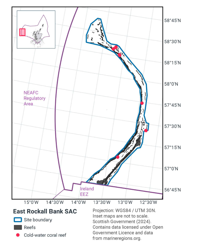
1.2 Site description
East Rockall Bank is located along the eastern flank of Rockall Bank, about 320 km west of the Outer Hebrides. The eastern edge of Rockall Bank forms a scalloped faulted scarp slope, which descends steeply down into the Rockall Trough at around 1,000 to 1,500 metres water depth (Howell et al. 2009, Long et al. 2010).
The site is protected for its Annex I reef, consisting of bedrock, biogenic and stony reef. Parasitic cones in the north of the site support sediment in-filled dead Lophelia pertusa framework and live cold water coral reef, with antipatharians and gorgonians. The eastern edge of the Rockall Bank summit comprises fine sand with iceberg plough marks where stony reef of mixed cobbles and pebbles supports erect bryozoans (such as Reteporella sp.), Munida sp. (squat lobster), axinellid sponges and encrusting sponges. The eastern flank of Rockall Bank comprises steep slopes between 400 to 750 metres depth which are composed of mixed substrates of boulders, cobbles, and pebbles with areas of exposed bedrock and bedrock outcrop (Howell et al. 2009). A rocky ledge of bedrock reef runs the length of the eastern flank, supporting assemblages of lace corals (Stylasterid) and lobose and encrusting sponges (Long et al. 2010). Further down the slope of the eastern flank, the substrate changes to stony reef, composed of boulders and cobbles which support lower abundances of Stylasterid corals and higher abundances of sponges. Two canyon features cut into the flanks of the site, and these are characterised by xenophyophores and decapod shrimps, with one canyon also supporting an abundance of caryophyllid corals and sea pens. Table 1 shows the area of reef habitat, including the different reef sub-types, present within the site.
The Conservation Objectives for the Annex I Reefs at East Rockall Bank SAC are:
For the feature to be in favourable condition, thus ensuring site integrity in the long-term and contribution to Favourable Conservation Status of Annex I Reefs. This contribution would be achieved by maintaining or restoring, subject to natural change, the:
- extent and distribution of the qualifying habitat in the site
- structure and function of the qualifying habitat in the site
- supporting processes on which the qualifying habitat relies
JNCC’s view on the overall condition of the site’s qualifying feature is that it is in unfavourable condition and therefore needs to be restored to favourable condition.
More information regarding the Designation Orders for the East Rockall Bank SAC is available in the Standard Data Form.
More information regarding the conservation objectives for the protected feature of East Rockall Bank SAC is available within the site’s conservation advice package available on JNCC’s site information centre.
| Reef type | Habitat area within SAC (km2) |
|---|---|
| Bedrock | 313 |
| Biogenic | 3 |
| Stony | 314 |
| Total | 630 |
1.3 Activities assessed
The process followed to conduct this ‘Fisheries Assessment’ is in line with the process for a Habitats Regulation Appraisal, as required under Article 6(3) of Council Directive 92/43/EEC of 21 May 1992 on the conservation of natural habitats and of wild fauna and flora (the Habitats Directive); for sites within the offshore region under Regulation 28 of the Conservation of Offshore Marine Habitats and Species Regulations 2017.
In this context, fishing activity within the SAC is considered to be the plan or project, and the implications of the fishing activity in view of the conservation objectives for the SAC are being assessed through the fisheries screening stage (Part A), the fisheries assessment (Part B), and the in combination (cumulative effect) assessment (Part C).
Fisheries assessments use the best available evidence to fully consider potential impacts of commercial fishing activity, and in-combination (cumulative) effects with other plans and projects, against the conservation objectives for the site. If the assessment concludes that use of certain fishing gear types is not compatible with the conservation objectives of the site, management measures will be considered.
Commercial sea fishing activity has the potential to vary in nature and intensity over time. This assessment considers fishing activity based on activity levels and type between 2015 to 2019. This date range was considered to provide the best available data on current fishing activity levels for the assessment. Using a five year date range provides an average view of fishing activity within the site; latter years (2020 to 2021) were not considered representative of regular fishing activity due to the Covid pandemic. The selected date range (2015 to 2019) was used consistently across all assessments within the consultation package. Changes in fishing activity after this time period may be considered in future reviews of this assessment (see Section 6).
Contact
Email: marine_biodiversity@gov.scot