West of Scotland Nature Conservation Marine Protected Area (NCMPA) site boundary amendment: final business and regulatory impact assessment
This assessment is undertaken to estimate the costs, benefits and risks of the proposed boundary amendment for the West of Scotland MPA that may impact the public, private or third sector. It has been updated following public consultation.
Background
The deep seas around Scotland are home to some of the most vulnerable and valued habitats and species on earth. Deep sea ecosystems provide a range of benefits to society, including nutrient cycling and carbon storage. The West of Scotland nature conservation marine protected area (NCMPA) was designated on the 25 September 2020 under the Marine and Coastal Access Act 2009. The site became the biggest marine protected area (MPA) located in national waters in the North-East Atlantic. However, within the current designated boundary of the West of Scotland NCMPA there is an administrative error.
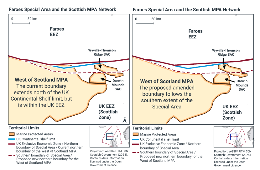
There is an area between Scotland and the Faroe Islands is sometimes referred to as the “Faroese Special Area” where the UK shares certain rights and jurisdiction with the Kingdom of Denmark and the Faroe Islands. Within this area the UK Economic Exclusion Zone (EEZ) extends beyond the UK continental shelf limits over the Faroese continental shelf. The West of Scotland NCMPA is designated up to the UK EEZ boundary, so a small part of the site overlaps this Special Area, and also the Faroese continental shelf. As Scottish Ministers do not have jurisdiction in respect of the seabed and subsoil within the Faroese continental shelf an amendment to the existing NCMPA boundary is proposed to remove the area of the NCMPA which overlaps the Special Area, and the Faroese continental shelf.
Removing this area would mean Scottish Ministers would have full jurisdiction within the West of Scotland NCMPA. The removal of the Special Area from the site would reduce the NCMPA by 2,307km2, which is 2.14% of the full site, as shown in Figure 1. The implementation of fisheries management measures, as proposed in the consultation on Fisheries Management Measures within Scottish Offshore Marine Protected Areas (MPAs), should follow the amendment of the site boundary for this NCMPA, to ensure that any measures introduced are applied to the correct area. It is important that the boundary reflects the intended conservation objectives before management measures are finalised and brought into effect.
Contact
Email: Marine_biodiversity@gov.scot