Marine (Scotland) Act 2010 - Marine Conservation Order provision changes: environmental report
This environmental report was produced as part of the strategic environmental assessment accompanying our consultation on facilitating marine nature restoration through legislation.
4 Environmental Baseline
4.1 Introduction
4.1.1 This section of the Environmental Report describes the character of the environment which may be affected by the proposed extension to MCO provisions. The focus of this baseline information is, therefore, on Biodiversity, Flora and Fauna; Soil (geodiversity); Water (the ecological status of WFD water and environmental status of the marine region under the UK Marine Strategy Regulations); Climatic Factors (carbon cycling, storage and sequestration); and Cultural Heritage (historic features), reflecting the scope of the assessment as described in Section 3.3. Whilst MCO provisions only apply to Scotland's territorial limits (i.e., inshore waters, to 12 NM), this section also considers the environmental baseline of offshore waters, given the potential for displacement of activities.
4.2 Overview
4.2.1 Scotland's location at the edge of the continental shelf means that it is subject to both subpolar and subtropical influences. The North Atlantic current brings warm water from the Gulf of Mexico to the west coast of Scotland. These warm waters mix with cooler polar waters from the Arctic in the north and east that are rich in nutrients. This unique geographic position means that the seas around Scotland contain a wide variety of habitats and species.
4.2.2 The Scottish marine environment covers an area of over 462,000 km2, the territorial sea limit (Scotland's inshore waters) of which is approximately 44,480 km2. The Scottish marine environment comprises a wide variety of habitats including intertidal rocky and sediment shores, subtidal rocky reefs and sandy / muddy sea bed to deep-sea sediment sea floor as well as the water column itself[81]. Scotland has over 18,000 km of coastline and its inshore and offshore areas are among the largest of any country in the European continent, representing 13% of all European seas.
4.3 Biodiversity, Flora and Fauna
4.3.1 Scotland's marine environment supports a diverse complex of different habitats, which in turn support a wide range of marine plants and animals. Estimates suggest there are around 6,500 species of animals and plants (excluding microbial flora and seabirds) in Scotland's seas[81[. Many of these occur within Scotland's inshore waters (0 – 12 NM).
4.3.2 There are a number of pressures on biodiversity within Scottish seas, linked to the development of industry in the marine environment. The Feature Activity Sensitivity Tool (FeAST) provides more comprehensive information on the relevant pressures associated with a range of marine activities and the sensitivity of marine features to these activities and pressures[82]. The tool has undergone a review and a new interface has been built.
4.3.3 Key pressures to species and habitats in Scotland's inshore waters include climate change, coastal developments, dredging, pollution, marine litter, seabed abrasion, invasive non-native species. The effect of these pressures is dependent on their intensity and the sensitivity and vulnerability (exposure) of marine and coastal species and habitats to these pressures.
Marine habitats
4.3.4 Benthic (seafloor) habitats are vital natural resources, as many marine species rely, directly or indirectly, on the seafloor to feed, hide, rest or reproduce. Generally benthic habitats are characterised by low mobility species[83]. Marine habitats within the Scottish marine environment can be characterised into three broad groups: intertidal habitats; subtidal (inshore and shelf sea); and deep sea habitats (found predominantly in offshore waters, and to a very limited extent inshore). These broad groups can be further broken down by substrate type. The seabed is a critical component of marine ecosystems. Overall, the inshore west coast is dominated by mud and sandy mud; coarse sediments are found inshore in the North; and the East coast inshore is dominated by sand and muddy sand (Figure 3).
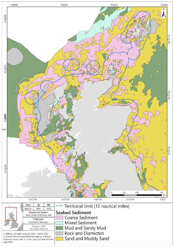
"Figure showing a map of Scotland and the seabed habitat sediments in Scotland. Map shows presence of coarse sediment; mixed sediment; mud and sandy mud; rock and diamicton; and sand and muddy sand. All sediment types are found in the inshore waters. The territorial limit of Scotland's waters (12 nautical miles) is also shown."
4.3.5 The information presented in Figure 4 on predicted seabed habitats is provided by National Marine Plan Interactive (NMPi) and European Marine Observation and Data Network (EMODnet) Seabed Habitats. The layer is a predictive European Nature Information System (EUNIS) seabed habitat map for the UK continental shelf, which has been created using five pre-processed input datasets: substrate, biological zone, energy, salinity and biogeographic region. The key is presented in Table 3.
|
EUNIS Code |
|---|---|
| Infralittoral rock and biogenic reef | A3, A3.1, A3.2, A3.3 |
|
A4, A4.1, A4.2, A4.3 |
|
A4.12 or A4.27 or A4.33, A4.27, A3.33 |
|
A5.13 |
|
A5.14 |
|
A5.15 |
|
A5.23 or A5.24 |
|
A5.25 or A5.26 |
|
A5.27 |
|
A5.33, A5.33 or A5.34, A5.34 |
|
A5.35, A5.35 or A5.36, A5.36 |
|
A5.37 |
|
A5.43 |
|
A5.44 |
|
A5.45 |
|
A6, A6.2, A6.3, A6.4, A6.4 or A6.5 |
|
A6.11 |
|
Na |
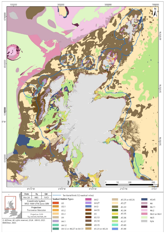
"Figure showing a map of Scotland and the seabed habitats in Scottish waters. Map shows presence of a wide range of habitats, the full details of which are provided in Table 3. The territorial limit of Scotland's waters (12 nautical miles) is also shown."
Mobile species
4.3.6 Scotland's marine environment supports a wide range of mobile species with several populations considered to be either of international or national importance. Several mobile species within Scottish waters are already protected through designation or classification of areas within Scottish waters or around Scottish coastlines as discussed below under 'Protected habitats and species'. Mobile species in Scottish waters include the following groups:
- Seals (grey and harbour seals);
- Cetaceans (23 species have been recorded in Scottish waters over the last 25 years; of these, 11 are regularly sighted[84]);
- Birds (both breeding seabirds and overwintering waterbirds);
- Fish, incorporating marine and diadromous species, including sharks, rays and skates; and
- European otter (inshore waters only).
Marine mammals (cetaceans, seals and otters)
4.3.7 Marine mammals are widely distributed around the Scottish coastline. Species distributions are a function of prey availability and habitat distribution. Eleven species of cetacean are regularly sighted around Scottish seas[84]. These comprise species with important resident populations, such as bottlenose dolphin, alongside more migratory species passing through Scottish seas, such as sperm whale. Key marine mammal species in Scottish seas include:
- Grey seal;
- Harbour seal;
- Harbour porpoise;
- Bottlenose dolphin;
- White-beaked dolphin;
- Fin whale;
- Minke whale;
- Short-beaked common dolphin;
- Atlantic white-sided dolphin;
- Risso's dolphin;
- Long-finned pilot whale;
- Killer whale;
- Sperm whale; and
- European otter.
4.3.8 All of the above species are Priority Marine Features (PMFs)[85], as discussed below under 'Priority Marine Features', and have been recorded inshore.
4.3.9 Cetaceans occur all around Scotland, with greatest diversity found off the continental shelf waters to the north and west. The abundances of harbour porpoise, white-beaked dolphin and minke whale in the North Sea are assessed as being stable. An earlier reported shift south in the distribution of harbour porpoise has been maintained[86]. The abundance of coastal bottlenose dolphins on the east coast of Scotland has increased and their distributional range has expanded southwards[87].
4.3.10 The Scottish grey seal population has increased, dominated by increases in the east coast populations[88]. Harbour seal populations are also distributed widely around Scotland, with stable populations identified on the west coast[88]. However, they have undergone a general decline in numbers elsewhere since 2001 for reasons which are unclear[89],[90]. The pattern of decline is not universal, with populations growing significantly around the Hebridean Islands[91], suggesting that these areas are important for this species.
4.3.11 In addition to the species discussed above, there is potential for humpback whales to be present throughout Scottish waters, with increasing records year on year[92], [93]. It is recognised that the majority of migrating individuals remain in deep water off the continental shelf[94] and therefore the exact distribution or number of individuals frequenting more inshore Scottish waters remains unknown, however there are records of humpback whales in more inshore waters both on the east and west coasts[95].
4.3.12 Otters are present around the Scottish coast, with the most recent population (including both coastal and riverine populations) estimated at approximately 8,000 individuals[96], [97]. They are protected through the designation of coastal and riverine sites throughout Scotland, as protected species under the Wildlife and Countryside Act and are designated as a PMF, with particularly significant populations on the west coast and the islands[97], generally in sheltered inshore waters. Foraging distances for otters are not well understood, however they are known to remain close to the coast and in relatively shallow water depths.
Birds
4.3.13 Scotland, and its coastline, is important for marine and coastal birds, including seabirds, seaducks, divers, grebes, waders and waterfowl. Scotland provides an essential feeding station for migrating birds; a safe winter haven for ducks, geese and shorebirds; and provides nesting sites for seabird species. It holds internationally significant numbers of 24 species of breeding seabirds, with additional migratory species of waterbird overwintering on Scotland's coasts[98].
4.3.14 An investigation into the temporal and spatial patterns of density for seabird species in eastern Scottish waters from digital aerial surveys undertaken between February 2020 and March 2021 determined the following species being recorded regularly; Northern Fulmar, Northern Gannet, Great Skua, Common Gull, Herring Gull, Great Black-backed Gull, Black-legged Kittiwake, Common Guillemot, Razorbill, Atlantic Puffin and Lesser Black-backed Gull[99].
4.3.15 Seabirds respond to a range of factors, such as changes in food availability, weather, predation and pollution. Breeding abundance and productivity is assessed for a number of the species that breed in Scotland based on a representative sample of colonies around Scotland, which are monitored as part of the UK Seabird Monitoring Programme[100].
4.3.16 Scotland hosts large numbers of wintering seaduck, divers and grebes. Seaducks undertake surface diving to capture molluscs such as mussels and clams as well as crustacea. Divers and grebes are predominantly piscivores or in some cases insectivores, preying on a variety of small fish such as clupeids, sandeel and small gadoids by undertaking pursuit diving.
4.3.17 Scotland is also important for large numbers of terrestrial bird species, several of which are known to migrate over long distances, including over areas of sea, particularly around the Hebridean Islands. Scotland's coasts are also of international important for wintering waterbirds, with indicators increasing by 15% since 2011[101].
4.3.18 In recent years White Tailed Sea Eagles have been re-introduced to Scotland, and a breeding population is now established on the west coast and in the Western Isles[102]. More recently a pair has started breeding on Hoy in Orkney. Sea Eagles, particularly juveniles, have large foraging areas and are known to fly long distances.
4.3.19 The highly pathogenic avian influenza (HPAI) virus H5N1 is circulating widely within wild bird populations in Scotland[103]. The situation is rapidly evolving and there is concern about the impact of HPAI on vulnerable bird species, particularly in waterfowl, seabirds and raptors. The outbreak has resulted in significant declines in the Svalbard population of barnacle geese, northern gannet and great skua[104]. HPAI has impacted on a wide range of wild bird populations, and caused reductions of conservation concern to some globally important Scottish populations of seabirds that could at best take many years to recover[104].
Fish
4.3.20 Scotland's inshore waters support approximately 250 different species of fish, with additional species occurring in deeper waters within the Scottish marine area. Some species are commercially important to the Scottish fishing industry, and others, such as sandeel, are key prey species for seabirds, marine mammals and larger fish species, including some shark species. There are several migratory anadromous fish species within Scottish waters which use Scottish rivers for spawning, including Atlantic salmon, shad, sea trout and lamprey. Thirty-one species of fish are identified as PMFs within Scottish waters[105].
4.3.21 Of the 250 species of fish identified in Scottish waters, 40 are cartilaginous fish (Chondrichthyes). Scotland has over 30 species of sharks, skates and rays recorded in its waters of which 25 are found in coastal waters[106]. Flapper skate are a critically endangered species. They were historically abundant in the North-east Atlantic and widely distributed in the seas surrounding the British Isles, however its range has reduced significantly and catch rates declined throughout the 20th century. The flapper skate now largely occurs in the northern North Sea and off Scotland's north-west coast, where an egg nursery area is protected through the Red Rocks and Longay MCO[107].
4.3.22 Within Scottish seas, there are nationally important populations of basking sharks. Significant numbers of sightings are concentrated around the Inner Hebridean islands of Coll, Tiree, Canna and Hyskeir and have been highlighted as potential breeding grounds. The basking shark migrates over large distances in both Scottish offshore and coastal waters at depths from the surface to over 750m. They are particularly associated with tidal fronts on the continental shelf and shelf edge where they feed on plankton.
4.3.23 The sandy ray occurs at depths from 70 to 275 m and is typically found on sandy or muddy sea beds to the north-west of Scotland. The thresher shark is typically found 40 to 75 miles offshore and is considered rare in Scottish waters. The blackmouth shark is found throughout Scottish waters but is more abundant in deeper offshore waters.
4.3.24 The Scotland Marine Assessment 2020[108] reports numbers of Atlantic salmon returning to Scotland's coast have declined since at least 1971 and fail to meet conservation targets. Approximately half of assessed stocks (95/193) are in poor conservation status.
4.3.25 Within Scottish waters, there are two species of lesser sandeel, Ammodytes tobianus which is largely found in coastal waters from the intertidal zone, and Ammodytes marinus which inhabits deeper waters[109]. Ammodytes marinus is the most abundant of the two species in Scottish waters and is a key prey species and component of the North East Atlantic ecosystem. However, little is known about its distribution outside of fished areas. Using distribution models, Langton and Wright (2021)[110] suggest lesser sandeel have a preferred depth range of 30 – 50 m and predicted habitat patches can be found at Jura, Islay and Colonsay that are within the Inner Hebrides, the Minches SAC and North East Lewis MPA.
Protected habitats and species
4.3.26 The importance of Scotland's marine ecosystems is reflected in the range of designations which protect them at international and national levels. The Scottish MPA network consists of 247 sites, 233 of these are for nature conservation purposes, covering 37% of Scotland's seas[111]. The current designations in Scottish inshore and offshore waters are:
- SACs: These include both inshore and offshore SAC and cover eleven different marine habitat types which occur in Scotland (sandbanks which are slightly covered by seawater all the time; estuaries; mudflats and sandflats not covered by seawater at low tide; coastal lagoons; large shallow inlets and bays; reefs; submarine structures made by leaking gases; and submerged or partially submerged sea caves). Seven marine species that occur in Scotland are also protected (bottlenose dolphin, harbour porpoise, grey seal, harbour seal, sea lamprey, Atlantic salmon and otter);
- SPAs: These protect and are of international importance for a number of bird species (e.g. seabirds, waders, ducks and geese);
- nature conservation MPAs: These protect habitats and species such as maerl beds, coral gardens and common skate;
- SSSIs: These are nationally designated sites which protect species such as seabirds and seals, and habitats such as sea caves and rocky shores; and
- Ramsar sites: There are designated for their internationally important wetlands. Each Ramsar site is also designated as either a SPA or SAC, depending on the features present.
4.3.27 Existing and proposed SAC, nature conservation MPA, and SPA sites are shown in Figure 5.
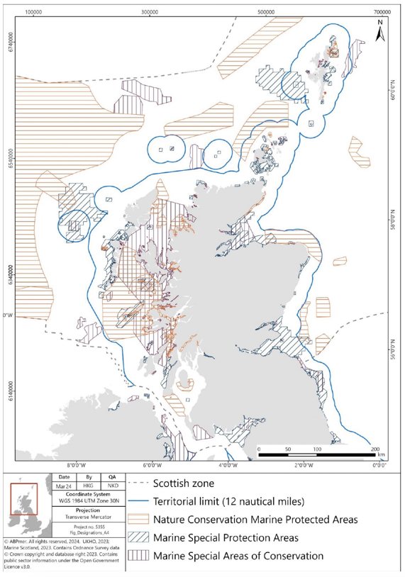
"Figure showing a map of Scotland and the SAC, nature conservation MPA, and SPA sites in Scottish waters. All designation types are found in inshore waters. The territorial limit of Scotland's waters (12 nautical miles) is also shown."
4.3.28 Scotland has 243 designated SACs (including three that straddle the border with England)[112]. Of the 243 SACs, 45 are found inshore, two straddle the inshore and offshore areas, and eight designated SACs are entirely in Scotland's offshore waters[113].
4.3.29 Scotland has 162 classified SPAs, from the north of Shetland to the cross-border Solway Firth SPA, as well as within inshore and offshore waters. This includes a suite of 12 marine SPAs which were classified in December 2020[114] and two SPAs near Orkney classified in 2022[115]. The 14 marine SPAs complement 30 colony SPAs (with marine extensions) in Scotland's SPA network which help to protect rare, vulnerable and regularly occurring migratory species that use Scotland's seas. These sites have been classified for their breeding seabird populations[116].
4.3.30 There are currently 36 nature conservation MPAs located within Scotland's seas, 13 of which are offshore[117]. There is also a D&R MPA around Fair Isle[118] (section 2.3), eight historic MPAs, and five Other Area Based Measures recognised as part of the Scottish MPA network[119].
4.3.31 There are 65 SSSIs[120] with marine components in Scotland. These include land and the foreshore generally only down to mean low water spring tide level.
4.3.32 There are also 51 Ramsar sites in Scotland designated as internationally important wetlands, covering a total area of about 326,719 hectares[121], of which 16 form part of the MPA network[122].
4.3.33 The Habitats Regulations[123] also affords protection to certain species of plants and animals (European Protected Species). In the marine environment these include cetaceans and otters.
Priority Marine Features
4.3.34 In July 2014, Scottish Ministers adopted a list of 81 PMFs. PMFs are species and habitats which have been identified as being of conservation importance to Scotland[124]. Most are a subset of species and habitats identified on national, UK or international lists.
4.3.35 The list of 81 PMFs comprises 26 broad habitats (e.g. burrowed mud), seven low or limited mobility species (e.g. ocean quahog) and 48 mobile species, including fish (e.g. blue ling) and marine mammals (e.g. minke whale).
4.3.36 Available PMF data relevant to Scottish waters are presented in Figure 6. The information has been collated in a computer database called GeMS (Geodatabase for Marine Habitats and Species adjacent to Scotland)[125].
4.3.37 Kelp beds, burrowed mud, maerl beds, seagrass, horse mussel beds, flame shell beds and Northern sea fan and sponge communities are examples of PMF habitats identified within the Scottish inshore area (Figure 6 – for fullness of picture PMF habitats are shown for both inshore and offshore waters). PMF species identified within the Scottish inshore area include basking shark, sand goby, whiting, harbour seal, grey seal, saithe, whiting, ocean quahog, northern feather star, flapper and blue skate and anglerfish (Figure 7).
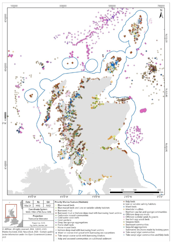
"Figure showing a map of Scotland and GEMS habitat data in Scottish waters. Map shows a wide range of PMF habitats found through Scottish inshore waters. Further details are provided in section 4.3.37. The territorial limit of Scotland's waters (12 nautical miles) is also shown."
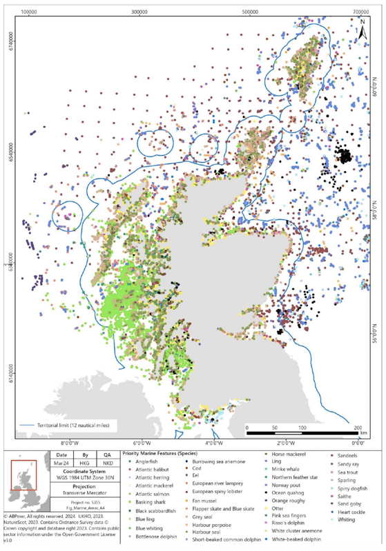
"Figure showing a map of Scotland and GEMS species data in Scottish waters. Map shows a wide range of PMF species found through Scottish inshore waters. Further details are provided in section 4.3.37. The territorial limit of Scotland's waters (12 nautical miles) is also shown."
Future Evolution of Baseline
4.3.38 The future baseline for biodiversity in Scottish seas is likely to be driven, certainly in the short term, by the current trends discussed above. However, there is currently very limited evidence to inform possible future trends, therefore this is an area of significant uncertainty. The Marine Scotland Assessment endeavoured to identify trends in pressures over the period 1 January 2014 to 31 December 2018, but it was decided that the lack of data precluded the determination of trends in the pressures[126]. This was identified as a data/knowledge gap which needs to be addressed to allow trends to be determined in the future.
4.3.39 In the longer term, continuing pressures from development of marine industry and wider human activities are likely to be key factors in driving changes from the current baseline. This includes effects from fishing practices, coastal development, and other activities in the marine environment (recreation, anchoring, commercial shipping, dredging etc.). These have the potential to affect biodiversity through a wide range of pathways including collision risk, bycatch, depletion of prey species, pollution events and damage to benthic habitats.
4.3.40 Climate change is likely to lead to changes in the distribution and abundance of species[127], driven by changes in water and air. This may include the spread northwards of warmer water species currently restricted to the more southern areas of the UK. The seas around the UK are projected to be 1.5 – 4ºC warmer, depending on location, with warming most pronounced in the Celtic, Irish and southern North Sea areas. Recent research has projected that these changes will reduce the spatial overlap of the habitat of some marine predators with their prey population distribution, namely grey seal, harbour seal, harbour porpoise and Black-legged Kittiwake[128].The seas are also projected to become less saline by the end of the 21st century, particularly in the North Sea areas[129]. In addition, potential increased ocean acidification may inhibit the growth organisms with shells (containing calcium carbonate) or with carbonate exoskeletons (coral, sea fans).
4.3.41 Several habitats and species within Scottish waters are considered to be in decline. Assessment for the UK Marine Strategy found estimated losses in coverage in six types of subtidal biogenic habitats (i.e. habitats formed by key animal or algal species): blue mussel, horse mussel, flame shell, maerl and seagrass beds, as well as serpulid aggregation[130]. It is estimated that 33% of UK seagrasses have been lost since the 1980s[131], but projects are now being initiated in Scottish waters to help recover the species[132]. A study has also found that maerl beds in Scotland are at risk of decline due to climate change[133].
4.3.42 The impact of the HPAI virus H5N1 is evolving and its future impact on vulnerable bird species in Scotland is not known. The situation is likely to be compounded by existing manmade and natural pressures that are being faced by bird populations, particularly climate change.
4.3.43 Changes in marine industry have the potential to affect species in several different ways. For example, some bird species have adapted to scavenge on fisheries' discarded bycatch, therefore a reduction in fishing activity can lead to a reduction in the population of these species. Conversely, where fisheries deplete prey, such as sandeel, for bird species, a reduction in fishing activity can lead to a recovery of the prey species and drive a recovery in some bird populations[134],[135].
4.3.44 In addition to changes in the baseline itself, there is potential for our understanding of the baseline to continue to develop. This is particularly pertinent with regard to understanding the effect of offshore wind farms on Kittiwake populations, as the current baseline in the East and North East regions suggests that the installed offshore wind farms have the potential to affect Kittiwake populations foraging from SPAs in the region. However, emerging evidence may reduce the predicted effects of offshore wind farms in collision risk assessments[136].
4.3.45 Similarly, changes in prey species distributions could affect marine mammal populations. Therefore, Scottish Government has explored further protection of prey populations, such as sandeel, which support both birds and cetaceans in Scottish seas, through the MPA network. In July 2023, Scottish Government launched a consultation on proposals to close fishing for sandeel in all Scottish waters[137]. Following this consultation, The Sandeel (Prohibition Of Fishing) (Scotland) Order 2024 was laid in the Scottish Parliament on 5 February 2024 and will come into force on 26 March 2024[138]. The continued development and management of the MPA network has the potential to support the maintenance of biodiversity, and potentially allow recovery of some species where current pressures are eliminated or reduced.
4.3.46 The Feature Activity Sensitivity Tool (FeAST) provides comprehensive information on the relevant pressures associated with a range of marine activities and the sensitivity of marine features to these activities and pressures[139]. The JNCC has also compiled a marine pressures-activities database (PAD) comprising 39 human use activity categories and 34 human pressure types[140]. These tools provide a comprehensive evidence base for understanding the relationships between these human activities and pressures within the marine environment.
4.3.47 Examples are set out below (section 4.3.48 – section 4.3.56) of activities and their potential effects on marine Biodiversity, Flora and Fauna. The FeAST and PAD tools provide more comprehensive information on the relevant pressures associated with a range of marine activities and the sensitivity of protected features to these activities and pressures[139], [140]
4.3.48 Commercial fishing:
- Removal of target fish species may affect the sustainability of fish stocks, particularly where catches are above the level consistent with achieving maximum sustainable yield;
- Discards of fish are a waste of the resource, and also encourage scavenger species;
- Bycatch of both non-target fish and other species;
- Abrasion of the seabed and its benthic habitat by mobile fishing gear, with the consequent loss of marine plants and animals; and
- Removal of target species may also decrease the availability of prey species, leading to declines in populations of other species (e.g. birds).
4.3.49 Navigation dredging:
- Can result in loss of and/or damage to the seabed and the habitat that it supports;
- May give rise to elevated suspended sediment concentrations, resulting in decreased water quality, reduced visibility for foraging fauna and/or smothering of the seabed if these sediments settle out in a different area; and
- May disturb marine animals, including through increased noise levels.
4.3.50 Marine transport:
- Risk of collision of vessels with marine animals, resulting in their injury and/or death;
- May result in increased coastal erosion through the action of vessel wakes;
- Vessel noise can impact marine animal behaviour and result in disturbance and / or displacement, including displacement of bird species from the water; and
- Introduction of non-native species may outcompete native species, thereby displacing them from the marine environment.
4.3.51 Aquaculture:
- May give rise to elevated nutrient levels in and on the seabed from fish faeces and excess animal feed, which can result in changes to community composition and/or smothering of the seabed;
- Elevated concentrations of contaminants used in sea lice treatment, fish health and anti-fouling;
- Nets associated with aquaculture can result in the injury and / or death of marine animals through entanglement;
- Can damage the seabed and its habitat through anchoring of infrastructure;
- May affect wild salmon through transmission of sea lice; and
- May disturb marine animals, including through increased noise levels associated with Acoustic Deterrent Device (ADD) operations at finfish aquaculture sites.
4.3.52 Marine wildlife watching:
- May result in increased disturbance and displacement to populations of marine animals such as whales, dolphins and bird species; and
- May give rise to collision risk of mobile species with vessels (e.g. birds, mammals etc.).
4.3.53 Recreation:
- May result in loss of and/or damage to the seabed and its habitat through anchoring;
- May give rise to increased levels of marine litter, which can result in the injury and/or death of marine animals through entanglement, ingestion of litter (including plastic microparticles in particular), or both;
- May disturb marine animals if the Scottish Marine Wildlife Watching Code is not adhered to through human and/or vessel presence; and
- May give rise to collision risk of mobile species with vessels (e.g. birds, mammals etc.).
4.3.54 Offshore renewables:
- May result in loss of and/or damage to the seabed and its habitat, through anchoring of infrastructure;
- May give rise to collision risk (e.g. with birds, mammals, etc.);
- Could result in changes to sediment transport through changes in energy levels in the water; and
- May disturb marine animals, particularly through increased noise levels associated with construction activities (e.g. percussive piling) and survey activities.
4.3.55 Survey Activities
- May disturb marine animals, through increased noise levels in the marine environment associated with the use of acoustic survey equipment; and
- May give rise to collision risk of mobile species with vessels (e.g. birds, mammals etc.).
4.3.56 Coastal Development
- May result in loss of and/or damage to the seabed and its habitat, through construction of infrastructure;
- Could result in changes to sediment transport through changes in coastal processes; and
- May disturb marine animals, through increased noise levels in the marine environment associated with construction activities.
4.4 Soil (Geodiversity)
Seafloor geodiversity
4.4.1 Geodiversity is defined as the natural range (diversity) of geological features (rocks, minerals, fossils and structures), geomorphological features (landforms and processes) and soil features that make up the landscape both on land and below water. The condition of underlying geodiversity features such as sand banks and seabed influence the quality of habitats which in turn affects the viability and health of both flora and fauna populations.
4.4.2 There are six broad features of Scottish geodiversity that are protected by nature conservation MPAs[141]:
- Quaternary of Scotland;
- Submarine Mass Movement;
- Marine Geomorphology of the Scottish Deep Ocean Seabed;
- Seabed Fluid and Gas Seep;
- Cenozoic Structures of the Atlantic Margin; and
- Marine Geomorphology of the Scottish Shelf Seabed.
4.4.3 Geological and geomorphological features of MPAs and SSSIs can be impacted upon by changes in physical processes as a result of natural and anthropogenic influences.
4.4.4 Each feature has a variety of components, such as continental slope channels, iceberg ploughmark fields, moraines, slide deposits, sand wave fields, pockmarks, seamounts, sand banks and mega-scale glacial lineation. Major physiographical features of the Scottish marine environment are shown in Figure 8 and demonstrates the shallower nature of inshore waters.
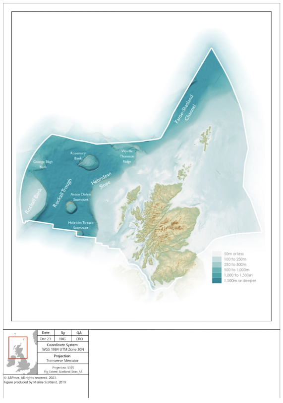
"Figure showing extent of Scotland's seas, showing bathymetry and locations of major physiographical features, including the Rockall Trough, Hebridean Slope, Wyville Thomson Ridge, Rosemary Bank, Hebridean Terrace Seamount, George Bligh Bank, and Rockall Bank. Water depths move from 50m or less inshore to 1,500 m or deeper in offshore waters. The territorial limit of Scotland's waters (12 nautical miles) is also shown."
4.4.5 Scottish waters are geomorphologically distinct between the east and west coasts. The east coast presents mostly uniform depths and shallow inclines interspersed with localised trenches, while the seabed off Scotland's west coast shelves steeply away from the coast, and deep waters occur relatively close to the land.
4.4.6 Data from the British Geological Society (BGS) indicates that Scottish waters have a wide range of seabed habitats, ranging from scoured rock or coarse sediment to muddy gravel or fine sand in some areas (Figure 3, section 4.3.4). A description of the key habitat types in Scottish waters is provided in 'Marine Habitats' in section 4.3.4 above.
4.4.7 In general, marine sediments are sandy or gravelly and originate from deposits during the Quaternary glaciation. Muddy sediments occur principally nearshore or, further offshore, in depressions on the sea floor, where currents may be relatively weak. They also occur beyond the shelf break (200 m water depth) to the west of Scotland. The concentration of calcareous material varies greatly in seabed sediments, reflecting the amount of shell material in different areas, and can locally be very high[142] .
Coastal geodiversity
4.4.8 Much of Scotland's landscape and coastline was initially formed through the processes of glacial erosion and deposition. Today the coast continues to change as a result of coastal processes such as wave action, sediment movement, erosion and accretion. The 2004 European Initiative for Sustainable Coastal Erosion Management (Eurosion) survey of Scotland's coastline reported that it comprises predominantly hard coasts of rocks and cliffs (70%); soft coasts that are potentially susceptible to erosion impacts, consisting of unconsolidated gravels, sand and silts (29%); and artificial coasts such as harbours and sea walls (less than 1%).
Future Evolution of Baseline
4.4.9 As previously detailed, the majority of the Scotland's coastline is composed of hard geology, meaning that it is relatively stable. However, there are areas of the Scottish marine environment that are more dynamic and therefore continuously experiencing changes that are outside the direct influence of human activities.
4.4.10 Changes to geological and geomorphological features can occur through physical and hydrological pressures. These pressures may be the result of natural processes (e.g. storms), changing climatic conditions and marine activities, such as the development of infrastructure on coastal and subtidal habitats.
4.4.11 Coasts are dynamic environments, continually changing in response to variations in weather, land use and the supply of sediment. This capacity to change encourages landholders to try to design schemes to restrict and control this natural dynamism. Restricting coasts affects water and sediment flows, which can destroy wildlife habitat and reduce landscape value and diversity. Intervention at one point of a coast can have a negative knock-on effect at another point in the dynamic landscape.
4.4.12 Work carried out as part of the National Coastal Change Assessment (NCCA) provides a shared evidence base which encompasses historic coastal change and highlights susceptible areas of the coastline[143].
4.4.13 In 2010-2011 it was estimated that around 12% of Scotland's coastline was erosional[144]. Following on from the Dynamic Coast NCCA, further research funded by the Scottish Government is ongoing to understand the potential damage from climate change to areas of the Scottish coastline categorised as 'soft' erodible coast, and how these effects can be mitigated[145].
4.4.14 The erosional portion of the Scottish coastline largely consists of beaches, sand dunes, conglomerates/soft-rock cliffs, machair and marshes with muddy sediments[146]. Areas most vulnerable to coastal erosion include the east coast from Montrose to Dunbar, the Firth of Clyde, the Inner Moray Firth, and the Northern and Western Isles [147].
4.4.15 Pressures on geodiversity features in Scottish seas arise from multiple activities, including fishing, infrastructure development, seafloor exploration activities, oil and gas extraction and renewable energy development[148].
4.5 Water
Ecological status of WFD bodies
4.5.1 There are various mechanisms in place for monitoring and managing the quality of Scottish inshore waters. Each takes a different focus and approach:
- The Water Framework Directive (WFD) establishes a framework for the protection of inland surface waters (rivers and lakes), transitional waters (estuaries), coastal waters (out to 1 NM (3 NM in Scotland)) and groundwater; with the aim of ensuring that all aquatic ecosystems meet 'good status';
- River Basin Management Plans (RBMPs) have been prepared for the Scotland and Solway-Tweed River Basin Districts to address the requirements of the WFD in relation to the management of Scotland's river systems. Both plans also provide an overview of the state of the water environment for their districts. The plans have been updated since the first cycle (2009 – 2015) and are currently in the second cycle (2015 – 2027); and
- Scotland's coastal waters are monitored by Scottish Environment Protection Agency (SEPA) to measure performance and compliance with targets for coastal water quality status under the WFD.
4.5.2 Coastal and transitional water bodies are classified in terms of their ecological and chemical quality. For those water bodies not designated as heavily modified or artificial, this ecological quality is described in terms of 'ecological status', which defines how much ecological quality deviates from natural conditions. The quality elements used to assess ecological status are:
- Biological quality elements (water, plants and animals);
- Chemical and physicochemical elements (e.g. oxygen and nutrient levels); and
- Hydromorphological quality elements (water flows and levels; the condition of beds, banks and shores; and the continuity of rivers for fish migration).
4.5.3 For good status, the chemical, physicochemical and hydromorphological quality of the water body must achieve the standards and conditions necessary for the biological quality elements to be in good condition. The ecological status of a water body is determined by the lowest-classed quality element.
4.5.4 The WFD requires surface and ground waters to be monitored and assessed, and plans for improvements in water quality to be developed and implemented where standards are not met. The majority of the 505 coastal and transitional water bodies in Scottish Waters, as represented in Figure 9, are classified as either good status (343) or high status (154), however some areas have been classified as moderate (6) or poor (2), principally due to pressures on morphology and macro-invertebrates[149].
4.5.5 In terms of protected areas under the WFD, there are 89 designated bathing waters and 80 designated shellfish waters in Scotland. The latest available classification data from 2023 assessed 38 bathing waters as excellent, 37 as good, 12 as sufficient, and 2 as poor status[150]. There are 80 shellfish water protected areas in the Scotland and in the Solway Tweed RBD[151]. The latest available classification from 2014, assessed 29 shellfish waters as at target objective, with the remaining 51 assessed as not at target objective[152].
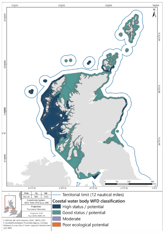
"Figure showing classification of coastal and transitional water bodies under WFD. Waters shown to be mostly of high status/potential and good status/potential. The territorial limit of Scotland's waters (12 nautical miles) is also shown."
Environmental status of marine region
4.5.6 The UK Marine Strategy provides the framework for delivering marine policy at the UK level and sets out how we will achieve the vision of clean, healthy, safe, productive and biologically diverse oceans and seas. The Strategy extends from the landward boundary of coastal waters (the equivalent to Mean High Water Springs) to the outer limit of the UK Exclusive Economic Zone (EEZ)[153]. The North-East Atlantic Ocean marine region and the Celtic Seas and Greater North Sea sub regions that overlap Scottish waters are shown on Figure 10.
4.5.7 Achieving GES under the UK Marine Strategy involves satisfying several elements (known as descriptors (D)), namely D1 biological biodiversity (cetaceans, seals, birds, fish, pelagic habitats and benthic habitats); D2 no indigenous species; D3 commercially-exploited fish and shellfish; D4 food webs (cetaceans, seals, birds, fish and pelagic habitats); D5 eutrophication; D6 sea floor integrity (pelagic habitats and benthic habitats); D7 hydrographical conditions; D8 contaminants; D9 contaminants in fish and other seafood for human consumption; D10 litter and D11 introduction of energy, including underwater noise[154].
4.5.8 The 2019 UK updated assessment and Good Environmental Status[154] reports for the North-East Atlantic Ocean marine region to not have achieved GES for birds, fish, benthic habitats, non-indigenous species, commercial fish and litter. It has partially achieved GES for cetaceans, seals, pelagic habitats, food webs and underwater noise. It has achieved GES for eutrophication, changes in hydrographical conditions, contaminants and contaminants in seafood.
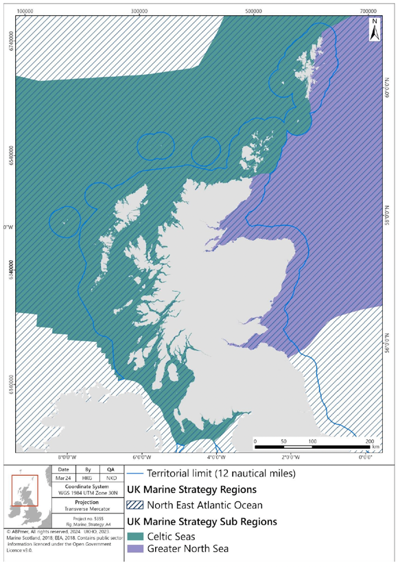
"Figure showing UK Marine Strategy region and subregions. The North East Atlantic Ocean Marine Strategy region covers all Scottish waters. The Celtic Seas subregion is shown to the west of Scotland and the Greater North Sea subregion to the east of Scotland. The territorial limit of Scotland's waters (12 nautical miles) is also shown."
Future Evolution of Baseline
4.5.9 Since the first River Basin Management Plans (RBMPs) in Scotland were published in 2009, the condition of water bodies has generally improved continuing a trend that has been observed since the 1980s following implementation of the Control of Pollution Act 1974. However, a wide range of pressures are continuing to affect the condition of specific water bodies and protected areas. The most widespread pressures on the marine environment in the Scotland RBMP are modifications to physical condition, rural diffuse pollution, waste water discharges and local pollution events such as oil spills[155], [156].
4.5.10 Pressures on water quality around Scottish coastlines are generally dependent on the level of marine industry and associated effects, together with land use. The future baseline will continue to be affected by similar pressures observed in the marine environment today, but the level of these pressures going forward is unknown.
4.5.11 In terms of GES, since 2012, environmental status has declined for birds, and has remained stable for cetaceans, pelagic habitats, benthic habitats, non-indigenous species, eutrophication, changes in hydrological conditions, litter and input of anthropogenic sound[156]. Environmental status has improved since 2012 for seals, fish, commercial fish and shellfish, food webs, contaminants, and contaminants in seafood.
4.5.12 Potential pressures against the UK Marine Strategy include those associated with increases in fishing activity, increases in oil and gas activity (and associated chemical discharges), increases in seabed extractive activities (i.e. seabed mining) and increases in offshore renewable development.
4.5.13 Higher marine traffic increases the potential for pollution events, however the modernisation of ships and more stringent inspection and maintenance regimes may reduce the occurrence of pollution events seen in a future baseline. The continued management of water quality through RBMPs has the potential to improve the status of coastal and transitional water bodies. The ongoing management of the North-East Atlantic Ocean marine region through a Programme of Measures (POMs) developed as part of the UK Marine Strategy has the potential to achieve or maintain GES of waters in Scotland.
4.6 Climatic Factors (including carbon cycling, storage and sequestration)
Climate Change
4.6.1 The key pressures on the climate are derived from the continued global emission of greenhouse gases, including carbon dioxide. These emissions are recognised as leading to changes in the global climate (including changes in temperatures, precipitation, storm density) in turn causing changes in the physical characteristics of the oceans, including potential changes in sea temperatures, circulation, salinity, pH and sea level rise. Global sea level has risen over the 20th century and will continue to rise over the coming centuries[157].
4.6.2 It is estimated that over the past four decades, sea surface temperature has increased by 0.6 °C, with the latest five year average being 0.2 °C above the 1981–2010 reference period and 0.4°C above the 1991–2020 reference period[158].
4.6.3 Worldwide sea pH has reduced by 0.1 in the period since the start of the industrial revolution[159]; and the sea level around the UK has risen by 15.4cm since 1900[160].
4.6.4 Scotland's ten warmest years on record have all occurred since 1997, and the average temperature in the last decade (2010 – 2019) was roughly 0.7 °C warmer than the 1961 – 1990 average. Furthermore, there has been an increase in rainfall in Scotland over the past few decades. The average year in the last decade was 9% wetter than the 1961 – 1990 average[161].
Carbon Cycle
4.6.5 The term 'carbon cycle' refers to the circulation of carbon in the environment. In the context of this report, it focusses on the exchange of carbon between the ocean and the atmosphere. The proportion of carbon incorporated into biomass is said to be 'stored'. Seagrasses, saltmarshes, biogenic calcifying reefs, kelp, and vegetated sand dunes all contribute to carbon cycling, sequestration, and storage[162].. The addition of solid carbon to these long-term stocks is referred to as sequestration, and the conversion of atmospheric carbon dioxide to solid carbon in living material is referred to as fixation. The stored carbon can be released, however, through physical disturbance, bacterial decomposition of organic matter or respiratory processes within the food chain.
4.6.6 The largest contribution to carbon fixation and sequestration in Scottish waters comes from phytoplankton, via photosynthesis and subsequent deposition of the produced organic matter in seabed sediments. This may occur either directly through the export of phytoplankton or indirectly through the consumption of phytoplankton by other organisms and subsequent export of this organic matter through the food chain[163].
4.6.7 Within the marine environment, habitats and processes capable of carbon fixation and sequestration are defined as 'blue carbon habitats'. Multiple habitats across Scottish seas and coastal areas can be termed blue carbon habitats due to their fixation and sequestration ability. Their effectiveness as carbon sinks is highly dependent upon their long-term capacity to store carbon.
4.6.8 Scottish blue carbon habitats are wide ranging and include: vegetated coastal habitats (saltmarsh, sand dunes, and machair) and nearshore habitats (including intertidal and subtidal seagrass beds and kelp) that produce and store organic carbon; calcifying aggregations (e.g., maerl, serpulid aggregations, and native oysters) that produce and store inorganic carbon within their structures; and seabed sediments, which receive, bury, and store organic and inorganic carbon[162].
4.6.9 Carbon stored in shallow shelf sediment tends to be ephemeral and constantly exchanged due to the dynamic nature of such habitats. Therefore, the potential for shallow shelf sediments to provide long term carbon storage is a function of sedimentation rates and the degree of recycling of organic carbon. The rate of recycling of organic carbon is driven by the level of oxygen available for bacterial and chemical breakdown of organic matter[163], which is primarily influenced by disturbance of seabed sediments and the oxygen content of the seawater above the seabed.
4.6.10 Deeper sediments are less mobile and dynamic and, therefore, are able to store carbon to a greater extent, but the rate of uptake into the sediment is slower as sedimentation rates in deeper waters are reduced. Deeper sediments are predominantly found in offshore waters.
4.6.11 Kelp forests, ubiquitous along the rocky shore common around Scotland, are identified as a significant carbon store (estimated to store ~0.6 Mt OC as standing stock within living biomass[162]). However, the fate of carbon within kelp (i.e. whether it is eventually sequestered permanently) is not quantified, and the majority of stored carbon in kelp is understood to be recycled rather than sequestered[163]. Recent studies have also highlighted the potential contribution of brittlestar beds to carbon storage in Scottish waters warrant further consideration[162]. Brittlestar beds are located primarily in inshore waters but can be found to depths of 85 m.
4.6.12 For many of Scotland's blue carbon habitats, a lack of extent data impedes the calculation of accurate estimates of carbon stocks. Additionally, there is a paucity of Scottish-specific sequestration and burial rate data for many habitats[162].
Future Evolution of Baseline
4.6.13 Predictions of the effects of climate change under all emissions scenarios suggest that several changes will occur within the marine environment. Key changes include increasing sea surface temperatures, sea level rise, increases in ocean acidity and potential changes in storm intensity (and hence wind and wave energy).
4.6.14 However, further reduction in emissions, through the continuing development of a de-carbonised energy sector, can support the Scottish, UK and International policy goals to limit greenhouse gas emissions and hence mitigate the progression and effects of climate change. In Scotland, between 1990 and 2021, there has been a 49.2% reduction in estimated emissions, a 40.3 MtCO2e decrease[164], driven by factors such as reductions in energy supply emissions (such as power stations) (77.6% reduction since baseline).
4.6.15 Climate change has the potential to affect the carbon sequestration capacity of marine habitats. Kelps and seagrasses are likely to be vulnerable to increases in the frequency of severe storms which have the potential to cause physical damage and reduce habitat extents and hence reduce carbon storage potential. For seagrasses, reductions in canopy density resulting from physical damage may also decrease this habitat's ability to trap sediment and deflect wave energy away from the bed. Carbon-storing sediments are, therefore, likely to be more vulnerable to wave scour and subsequent resuspension during severe storms. Resuspension events increase the opportunity for organisms to recycle any biologically available carbon from the sediment, reducing sequestration in the sediment once it re-settles on the seabed.
4.6.16 Such storm events are also likely to increase the turbidity of the water through increased sediment resuspension, which could potentially reduce available light for photosynthesis, reducing growth rates and, therefore, reducing the overall carbon sequestration capacity of marine habitats. However, in offshore areas, storm events will have no influence on turbidity due to the water depths.
4.6.17 Several marine activities (e.g. fishing, deep sea mining, oil and gas activities and renewable energy development) physically disturb the seafloor. As previously stated, any physical damage caused to a habitat has the potential to disturb, remove or release any carbon held within that store. However, it may also increase other nutrient levels, which could in turn increase the levels of primary production. The level of impact will depend on the specific area affected. The dominant controls on the release of carbon have been found to relate to the intensity of trawling (a function of the depth to which carbon was disturbed, the particulate organic carbon content of the sediment, and the fraction redeposited without mineralisation)[165]. In general, direct physical disturbance from marine activities has the potential to affect how Scotland's marine environments regulate atmospheric carbon levels.
4.6.18 A number of blue carbon habitats are currently thought to be declining, including maerl and flame shell beds. However, the current MPA programme is expected to contribute to halting or even reversing the decline of habitats within the MPAs.
4.6.19 Shelf seas around the UK are predicted to be 1°C to 4°C warmer by the end of the 21st century[166]. Warmer sea temperatures could result in a shift in distribution of certain habitats and species. Climate change may also favour some species, leading to a potential increase in the diversity of seabed marine life[167]. Biodiversity and benthic biomass in the deep oceans, however, are generally predicted to decrease as a result of climate change[168].
4.6.20 An increase in atmospheric carbon dioxide will lead to a subsequent increase in dissolved CO2 concentrations within the ocean, increasing ocean acidity. This has the potential to hinder calcium carbonate producing organisms, and, therefore, their ability to sequester carbon in the long term. In addition, following mortality of such organisms, there is increased potential for carbonate shells or skeletons to dissolve faster, in both shallow shelf seas and deeper ecosystems, and, therefore, recycle greater amounts of carbon before they can be sequestered in seabed sediments. This pathway is particularly significant where the carbonate pump forms a considerable portion of the carbon export to deep sea sediments.
4.7 Cultural Heritage
4.7.1 Key pressures on historic marine environment and archaeological features are from climatic conditions, including storm events, physical processes (e.g. leading to erosion) and human activities such as coastal and offshore infrastructure developments.
4.7.2 Many cultural heritage features are designated and thus afforded some degree of protection; however, there is considerable uncertainty on the location, extent and status of many subtidal marine historical assets.
4.7.3 Loss, damage and modification of historic assets and their settings can occur through a range of marine activities and infrastructure developments. Where the construction or operation of offshore marine developments, including their associated infrastructure (e.g. subsea cables, coastal substations etc.), overlaps with historical features then there is the potential for direct effects to arise on the feature and its setting. Indirect effects on historical features may also occur from changes in physical processes and sediment transport regimes resulting from offshore infrastructure.
Designated Historical Sites and Shipwrecks
4.7.4 There are numerous scheduled monuments and listed buildings along the Scottish coastline, with designated wrecks and military remains sites identified both inshore and offshore. Three of Scotland's six designated World Heritage Sites (WHS) are on the coast (St. Kilda; The Heart of Neolithic Orkney; The Forth Bridge). The Antonine Wall runs across central Scotland, from Old Kilpatrick in the west to Bo'ness in the east. (Figure 11). The Crucible of Iron Age Shetland is also on the Tentative List for a future WHS[169].
4.7.5 Other key coastal features include a number of Category A listed lighthouses, ecclesiastical remains, coastal heritage museums, military defences, harbours, forts and castles.
4.7.6 Historic MPAs are designated under Section 67 of the Marine Scotland Act 2010 to protect marine historic assets (e.g. historic shipwrecks) of national importance within Scottish Territorial waters (up to 12 NM from the coast). There are currently 9 Historic MPAs designated within Scottish waters[170] (Figure 11).
4.7.7 In addition to the historic MPAs, there are a number of other designated sites that overlap with the coastal and marine environment including eight designated wrecks, nine scheduled monuments, four listed buildings and 20 sites and vessels designated under the Protection of Military Remains Act 1986 (Figure 11).
4.7.8 There are also numerous shipwrecks around Scotland, an estimate puts this in the region of 20,000[171].
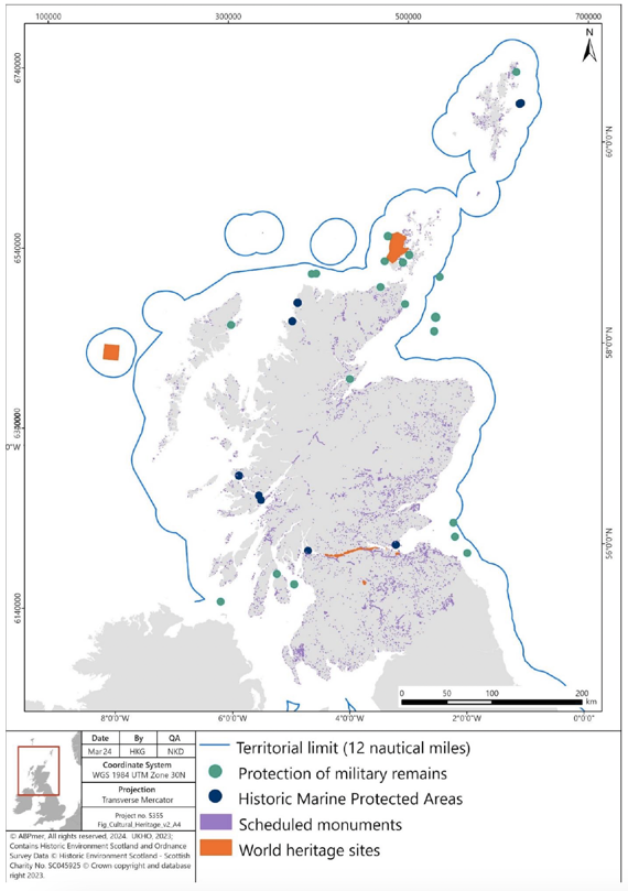
"Figure showing cultural heritage sites in Scotland including Protection of Military Remains, Historic MPAs, Scheduled Monuments, and WHS. All types of cultural heritage sites are shown in Scottish inshore waters. The territorial limit of Scotland's waters (12 nautical miles) is also shown."
Future Evolution of Baseline
4.7.9 Pressures from coastal erosion and climatic conditions will continue to affect the historic environment with climate change potentially exacerbating the erosive and destructive effects from physical processes. Pressures from human development will also affect the setting of historic assets.
4.7.10 The Scottish Coastal Archaeology and the Problem of Erosion Trust (SCAPE) provides an indication of coastal heritage sites around Scotland which are threatened by erosion[172]. The works highlights those coastal sites seen most at risk from erosion.
4.7.11 An increase in visitors to historic sites in Scotland may increase pressure on the sites. However, sites such as Skara-Brae in the Heart of Neolithic Orkney WHS will continue to be actively managed through the adoption of individual site management plans and government and agency commitments, to minimise the risk of effects from visitor disturbance and erosion.
Contact
Email: marinerestoration@gov.scot