Designing a pilot remote and rural migration scheme: analysis and policy options
This report sets out analysis and policy options to inform a potential pilot scheme for migration to remote and rural areas of Scotland.
1. Population Trends in Remote and Rural Areas
This chapter explores population trends in remote and rural parts of Scotland. It begins (section 1.1) by illustrating the complexity of patterns of change at the most detailed geographic level (data-zone), and for three broad age groups. However, at this level of granularity it is very difficult to understand the overall narrative of recent changes, and for this reason we introduce a discussion of different ways of classifying remote and rural areas (1.2). We then consider population trends in these areas, looking at changes in overall population and age structure (1.3), and migration (1.4).
1.1 Patterns of Population Change at the Local Level
Remote Scotland has experienced a long history of demographic decline, dating back to the Highland Clearances of the 18th and 19th centuries. In terms of age structure legacy effects, it would be interesting to track change since the middle of the last century. However, for small area analysis with a consistent data set we are limited to the period 2001-19.
The Scottish population as a whole has seen fairly steady growth over the past two decades. The population was 8% higher in 2019 than it was in 2001. However, many parts of rural Scotland have seen periods of both growth and decline since 2001. Generally speaking, the first few years of the new century were characterised by growth, even in the most remote areas of Scotland. However, from the later years of the first decade, change turned negative in the more remote parts of Scotland, whilst the upward trend was sustained only within the most accessible rural areas.
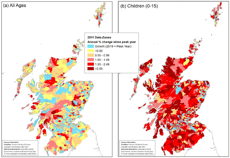
The best way to capture variations in population change across different areas is through data-zone mapping, drawing on the Small Area Population Estimates (SAPE) produced by National Records of Scotland (NRS). These provide population estimates for 6,976 data-zones across Scotland, each containing approximately 500-1,000 people. The SAPE offer population estimates for each year since the 2001 census. Using these data, we can identify the year of peak population, and then calculate the average annual percentage change since that date.
For many more accessible parts of the country, growth has been continuous, and peak population is recorded in 2019. These areas are shaded blue in Figure 1.1a. The yellow-red shaded areas have been losing population for all or part of the last two decades. The distribution of blue and red areas across Scotland demonstrates the complexity of patterns of population change, and serves as a warning against simplistic generalisations. The pattern is very fragmented, and maps like Figure 1.1 tend to make rural-urban comparisons challenging, but as the aggregate analysis in Section 1.3 indicates, remote parts of Scotland have shown the most consistent decline.
Source: Derived from NRS Small Area Population Estimates Time Series Data
Source: Derived from NRS Small Area Population Estimates Time Series Data
Figures 1.1b-d show that the overall trend masks important age-related differences. Decline has been more rapid and widespread for children (Figure 1.1b). The population of pensioners has grown in most parts of rural Scotland (Figure 1.1d). The pattern for the working age population is intermediate between these two extremes (Figure 1.1c). Arguably it is the working age population that is most relevant to this report, since it is working age migrants who can contribute most to strategic mitigation. However, children are of course crucial to the demographic sustainability of rural Scotland.
This breakdown of population growth by data-zone provides important insights into detailed local demographic patterns; but it is less helpful as a framework for understanding broader trends. For this we need to group zones into larger geographical areas. Such a framework can facilitate analysis of different age groups within the population, which for many rural data-zones is rendered precarious by the small numbers involved. It will also assist in the identification of viable units for inclusion in pilot schemes.
1.2 Classifying remote rural and sparsely population areas
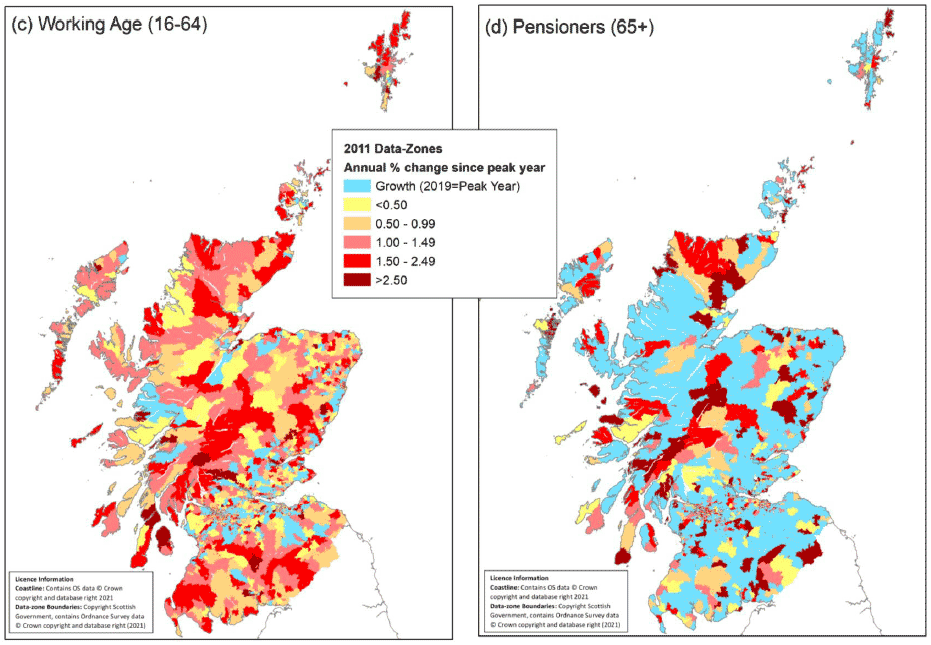
For these reasons it is helpful to group data-zones by rurality and remoteness. Our starting point is Scottish Government's 2016 Urban-Rural classification.
Source: Scottish Government 8-fold Urban-Rural Classification
Note: Figure 1.2b is derived from a combination of Scottish Government 8-fold Urban-Rural classification and James Hutton Institute SPA classification
The 8-fold version (Figure 1.2a) is more useful than the 6-fold version for a study of population change, because it separates the very remote rural areas and small towns. The remote rural areas of the 6-fold classification are defined by a drive-time contour of 30 minutes from a settlement of 10,000 persons. This incorporates a very large and diverse area - much of which has seen population growth in recent years. The very remote area is defined by 60-minute drive-time from a settlement.
The boundaries of the Urban-Rural classification follow the drive-time contours. In order to relate our (SAPE-based) analysis of population trends to this classification it is necessary to produce a 'best fit' map of data-zones. Figure 1.2b shows Scotland's data-zones classified according to which Urban-Rural category their centroid falls within.
As Figure 1.2a shows, the Urban-Rural classification designates almost all of the three Island Council Areas, and the north and west of Highland, including the areas immediately surrounding the three island capitals, together with Thurso, Wick and Oban, as 'very remote rural'. However, as Figure 1.1a shows, the immediate commuting zones around these centres exhibit very different demographic characteristics to the rest of very remote rural. These areas can be separated if we overlay the 'Sparsely Populated Area' (SPA) (Figure 1.2b).[8] The SPA was specified (at output area level) using a 'population potential' approach, based on the total population which fell within a 30-minute drive-time. For the purposes of this analysis, data-zones 100% within the SPA boundary have been identified as SPA. On this basis the areas adjacent to the Islands capitals can form a separate category, which we have labelled 'very remote rural (outside SPA)'. This category also covers an area around the Dornoch Firth, Speyside, and around Lochgilphead.
1.3 Population trends
The particular demographic challenges faced by remote and rural areas may be illustrated in greater detail through an analysis of the NRS Small Area Population Estimates (SAPE).
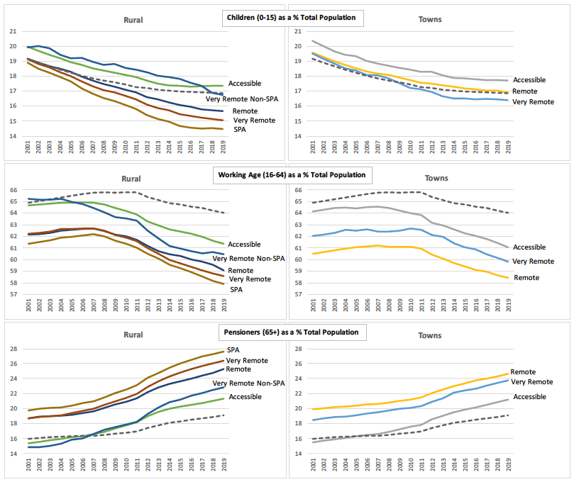
Table 1.1 provides some basic demographic data for each of the urban rural categories shown in Figure 1,2b. Remote and very remote rural and small town data-zones are home to less than 10% of the total population of Scotland. Whilst urban, accessible and even remote rural areas continued to grow in the two decades prior to 2019, the populations of very remote rural areas and small towns have declined in recent years. A similar, but more negative, pattern is seen in the working age population, with peak population occurring in 2011 in all the small town categories, and in 2007/8 in the remote/very remote rural categories.
| Total Population ('000) | Peak Year | Working Age Population ('000) | Peak Year | |||
|---|---|---|---|---|---|---|
| 2001 | 2019 | 2001 | 2019 | |||
| Large Urban | 1,748 | 1,911 | 2019 | 1,157 | 1,303 | 2019 |
| Other Urban | 1,854 | 1,960 | 2017 | 1,201 | 1,232 | 2011 |
| Accessible Small Towns | 441 | 469 | 2019 | 283 | 286 | 2011 |
| Remote Small Towns | 117 | 125 | 2019 | 71 | 73 | 2011 |
| Very Remote Small Towns | 69 | 66 | 2011 | 43 | 39 | 2011 |
| Accessible Rural | 535 | 617 | 2019 | 346 | 378 | 2019 |
| Remote Rural | 156 | 167 | 2019 | 97 | 98 | 2007 |
| Very Remote Rural | 145 | 150 | 2010 | 90 | 88 | 2008 |
| SPA | 113 | 111 | 2007 | 70 | 64 | 2007 |
| Very Remote Rural Non-SPA | 31 | 39 | 2019 | 20 | 24 | 2019 |
| Scotland | 5,064 | 5,463 | 2019 | 3,287 | 3,498 | 2019 |
Source: NRS Small Area Population Estimates
Note: The table rows are a combination of the Scottish Government 8-fold Urban-Rural classification and James Hutton Institute SPA classification.
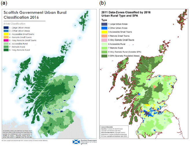
Between 2001 and 2019 the total population of Scotland (dashed line on Figures 1.3-1.5) increased by 8%. That of remote, very remote, and SPA data-zones initially grew faster than Scotland as a whole, reaching a peak in the second half of the noughties, then declined. The SPA population reached a point more than 2% below its 2001 level, whilst the remote and very remote areas remain above their starting point in 2001. In contrast the population of accessible rural areas has consistently out-performed that of Scotland as a whole. Perhaps most surprisingly the fastest growing group of data-zones (though also by far the smallest in population terms) was the very remote rural
Source: NRS Small Area Population Estimates
Notes:
(i) Estimated by aggregating data zones according to Scottish Government Urban-Rural classification and James Hutton Institute SPA classification.
(ii) Black dashed line is Scotland average.
Population trends in small towns (Figure 1.3b) were rather more subdued. Accessible Small Towns closely followed the national trend, whilst remote towns grew slightly more rapidly until 2011, but subsequently levelled off, converging with the national trend by 2019. Very remote towns showed stability until 2011, but then contracted by almost 5%.
Turning to the age structure of the population, SAPE data shows that across Scotland, the percentage of the population in the 0-15 age group declined from 19% in 2001 to a little under 17% in 2019 (Figure 1.4a). The child populations of remote, very remote and SPA data-zones were at a similar level in 2001, but over the past two decades their shares have all contracted more rapidly - reaching between 14.5% (SPA) and 15.5% (remote).
Source: NRS Small Area Population Estimates
Notes:
(i) Estimated by aggregating data zones according to Scottish Government Urban-Rural classification and James Hutton Institute SPA classification.
(ii) Black dashed line is Scotland average.
The working age share of the Scottish population (Figure 1.4b) rose slightly from 2001 to 2011, reaching almost 66%, thereafter declining steadily, reaching 64% in 2019. All but one of the rural groups of data-zones had a similar profile over the two decades, but with an earlier onset and deeper decline. Accessible rural areas and the non-SPA part of very remote rural were both close to the Scottish average at the beginning of the period, but diverged steadily, so that by 2019 they were approximately 2.5% and 3.5% lower than the country as a whole. The remote, very remote and SPA areas began the period with their working age share 2-3% below the average, and ended it 4-5% below.
The pensioner (over 65) share of the Scottish population was 16% in 2001 (Figure 1.4c). It rose steadily over the next two decades, reaching 19% by 2019. All the rural groups of data-zones showed a steeper upward trend in the share of pensioners. The remote, very remote and SPA groups were already well above the Scottish average in 2001, and by 2019 the SPA share was almost 10% higher. Among the small towns groups the trends were very similar, with the accessible towns beginning slightly below the Scottish average and finishing 2% above. Remote and very remote towns had a higher share of pensioners throughout the period.
The above account illustrates the familiar story of demographic ageing, which is more severe in rural and remote areas than in the urban parts of the country. The trend in working age population, which has two segments, initially increasing and later turning negative, is particularly interesting. The key finding here is that by 2019 the share of population of working age in remote and rural areas and towns was 6-7 percentage points below the Scottish average. The significance of the ageing process for migration policy lies in the fact that the ageing of the population has consequences for its capacity for natural increase, reducing the number of births and increasing the number of deaths. As a consequence, the only way for an ageing population to grow is through expanding in-migration.
1.4 Migration trends
As we have shown in previous EAG reports[9] [10] population decline in remote and rural areas has not been offset by in-migration. In this section, we briefly consider patterns of both Scotland/UK and international migration into and out of these areas. This is relevant both for understanding the demographic challenges of remote and rural areas, and also for reflecting on the design of a future RRMS.
Source: NRS Small Area Population Estimates; Urban-Rural Analysis Table 3
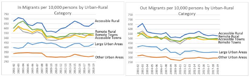
In order to explore trends in migration to remote and rural areas, we draw on a table provided by National Records of Scotland as part of the SAPE, which is disaggregated according to the six-fold classification (Figure 1.5). These data do not distinguish overseas migration from that originating in other parts of the UK, or mobility within Scotland.
These data indicate that rural areas and small towns, especially in accessible areas, have more mobile populations than the cities - rural areas and small towns have higher rates of both in and out migration per 10,000 head of population. This may reflect a greater propensity to relocate in search of jobs and services. The trend over time is less clear, although all areas appear to have experienced a gradual reduction in both in and out flows in the 2000s. After 2011 there appears to have been a rising trend which levelled off during the second half of the decade.
Source: NRS Small Area Population Estimates; Urban-Rural Analysis Table 3
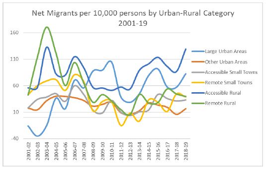
Patterns and trends of net migration are less clear (Figure 1.6). During the first few years of the century, remote rural and accessible rural had the most positive net migration rates (per 10,000 head of population), whilst the large urban areas showed negative rates. By the end of the period, although accessible rural areas remained in the most positive position, the rates for remote rural areas had moved down close to zero, whilst the large urban areas had the second most positive rates.
Only a very small proportion of this migration involved migrants from overseas. The RESAS classification of Council Areas[11] groups the three Island Areas and Argyll and Bute in the category 'Islands and Remote Rural'. According to NRS Local Area Migration data, only 7% of in-migrants to these areas, in the year 2017-18, originated overseas. In the Mainly Rural, and Urban with Substantial Rural Council Areas the proportion was a little higher, at 8% and 9% respectively. In the Larger City Council Areas the proportion was three times greater, at 28%.
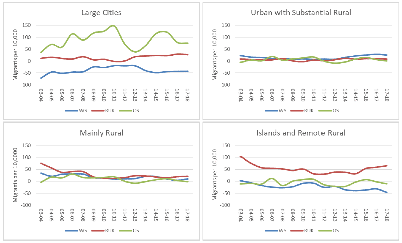
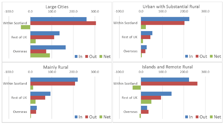
Figure 1.7 illustrates the trends in net migration rates (per 10,000) from within Scotland, from the rest of the UK, and from overseas, for the four RESAS groups of Council Area. As one might expect, the Large Cities group shows net out-migration to the rest of Scotland, and positive net migration from overseas; and a net migration rate close to zero for UK flows. There are large fluctuations, particularly for overseas migration.
At the other end of the urban-rural continuum, the graph for the Islands and Remote Rural Council Areas shows a declining, and increasingly negative, net migration rate from within Scotland, and an overseas migration rate fluctuating around zero. Flows from the rest of the UK are the most positive, and latterly increasing. The two intermediate groups of Council Areas show much smaller differentiation between the three sources of migrants, all of which have rates per 10,000 close to zero.
Source: NRS Local Area Migration data 2018
Net migration rates, expressed in rates per 10,000, do not, however, give any impression of the absolute size of in and out flows. Figure 1.8 shows that in all four groups of Council Areas, flows from within Scotland were by far the largest, and those from overseas the smallest. In the Islands and Remote group, the net effect of within-Scotland migration, and migration from overseas, were both negative. Of the three sources only the rest of the UK had a positive impact upon total population, averaging an additional 50 persons per 10,000.
Source: NRS Local Area Migration data 2018
Contact
Email: population@gov.scot