Scottish Marine and Freshwater Science Volume 3 Number 3: Clyde Ecosystem Review
A review of previously published information and knowledge concerning the Firth of Clyde ecosystem and suggestions for further studies in the Clyde required in order to support sustainable use of this active Scottish marine ecosystem
1. EXECUTIVE SUMMARY
In July 2010 a scientific paper authored by researchers from York University was published, entitled "Ecological Meltdown in the Firth of Clyde, Scotland, Two Centuries of Change in a Coastal Marine Ecosystem" (Thurston and Roberts, 2010).
This stimulated immediate media interest (Glasgow Herald and Sunday Times articles, Radio 5 live) and a BBC Panorama programme in August.
Subsequently, Marine Scotland Science ( MSS) commenced work which led to this review of the Clyde Ecosystem.
Independently from the process underway within Marine Scotland, the University of Strathclyde also commenced work on the issue of the ecological status of the Clyde.
While Thurston and Roberts (2010) relied entirely on landings data, the University of Strathclyde study used research vessel survey data obtained from MSS.
As a result of a detailed and well-found analysis, in July 2011 Professor Heath published a definitive analysis of the present state of the Clyde Sea demersal fish community in his paper, with Dr Doug Speirs, entitled "Changes in species diversity and size composition in the Firth of Clyde demersal fish community (1927-2009)" (Heath and Speirs, 2011).
The conclusions of Heath and Speirs (2011) point to a major ecological impact of fishing in the Clyde.
However, the picture portrayed by Heath and Speirs is not one of an ecological desert, but of an altered ecosystem. Their principal conclusions were,
- rather than commercial species being entirely removed from the Clyde, the biomass of the six main commercial species in the late 2000s was approximately double that prior to the onset of trawling in the 1960s.
- however, the size structures of these species were dramatically different, being markedly deficient in large commercially marketable individuals after the period of peak harvesting rates in the 1980s
- also the incidence of species with a maximum attainable length greater than 40 cm declined precipitously and did not recover during the period of low harvesting rates after the late 1990s possibly owing to internal predator-prey interactions.
This means that the Clyde Sea still functions as an ecosystem. Primary production still occurs, powered by the sun and supplied by water-borne nutrients, which sustains secondary zooplankton production, which in turn feeds an active food web. The Clyde is not an ecological desert.
However, the Clyde ecosystem has been changed. The biomass of fish in the Clyde is the same, or for some species more, than when intensive fishing started.
Additionally, a large and healthy population of shellfish ( Nephrops) living on the sea bed of the Clyde is present.
However, the community of fish is now made up mostly of small fish, and mostly small whiting.
If we were to seek a terrestrial analogy it would not be that of a desert. Rather it might be that of used agricultural land in need of restoration. Comparing the Clyde to an ecosystem modified by human use yet capable of restoration portrays a much less news-worthy image than an ecological desert.
The Clyde ecosystem is one that has been used by humans for centuries, and hence it is changed. But humans can also now influence the direction the ecosystem takes by managing human activities in the future, precisely because the Clyde is not an ecological desert, but is an active ecosystem with great potential for future sustainable use.
In some respects this report marks the start of a process, rather than the conclusion of one. It poses more questions than it answers, and presents preliminary analysis of a new data set that requires further validation, checking and expansion.
However, it provides a start point from which government and stakeholders concerned with the future of the Clyde can build upon and progress. It puts into context some secondary issues which may cloud the primary focus of future work to recover the Clyde ecosystem; how we manage fisheries in the Clyde.
The report which follows has the following objectives,
- To present a brief review of previously published information and knowledge concerning the Firth of Clyde ecosystem.
- To present the findings of Heath and Speirs (2011) in a format accessible to stakeholders and managers.
- To propose a data tool which may help inform future management options in the Clyde.
- To make suggestions for further studies in the Clyde required in order to support sustainable use of this active Scottish marine ecosystem.
1.2 Literature Review - Environment
The Clyde Sea presents the overall characteristics of a semi-enclosed fjordic basin, receiving freshwater inputs from the land and having partial exchange with the waters on the adjacent coastal shelf at its mouth.
The sea bed physical habitats in the Clyde are dominated by the local depth, the local sediment type and the local tidal currents and wave action. The predominant shape and bathymetry of the Clyde basin, and the distribution of the principal sea bed types, including the gravels, sands and muds, have been little changed since the end of the last glacial period (ice age).
The basis of the marine food web in the Clyde, i.e. the annual cycle of plant (phytoplankton) growth, fed by water-borne nutrients, and the subsequent feeding and growth of microscopic animals (zooplankton), appears healthy and productive in the Clyde.
From large scale observations, there are no obvious signs of negative effects on the food web of pollution, nutrient enrichment or any other man-made source of contamination. This does not preclude the possibility of small-scale local effects.
Although the waters of the Clyde Sea are warming, this is in line with other coastal areas west of Scotland. There is no evidence that the warming in itself has reduced the potential productivity of the Clyde.
1.3 Literature Review - Biodiversity
The Clyde Sea area has a wide range of habitats which support a large diversity of plant and animal species.
There is some concern that human activities may have already had effects on those species and habitats, through overexploitation, habitat destruction and environmental change.
Historically the Clyde has supported large populations of herring and whitefish, which have in recent years undergone a dramatic decline, and commercial fishing is now largely dependent on shellfish species.
The fauna of the Clyde does show some anomalies when compared with that of the west coast, particularly the Clyde algal fauna, with some species only found in the Clyde.
The seas of the Clyde also support populations of megafauna such as seals, dolphins, whales and basking sharks. Many of these species and habitats of the Clyde are recognised as being of national or international importance and have been afforded some level of protection under legislation to protect marine biodiversity.
Maerl
One benthic habitat of particular interest and concern in the Clyde is that associated with maerl beds.
Maerl beds are living sediments characterised by accumulations of unattached calcareous red algae (Corallinales, Rhodophyta), also known as rhodolith beds. They occur in many environments including tropical, temperate and polar environments. In Europe they are patchily distributed occurring throughout the Mediterranean and along the Western Atlantic coast.
Maerl beds appear as patchy, poorly sorted and complex sediment that differ greatly from more uniform habitats such as mud. The interlocking of the branching thalli creates a highly complex habitat that provides numerous microhabitats for macrofaunal organisms. They have high ecological importance as they support a wide range of species, some of which may be unique to this habitat.
Maerl beds can also be of importance to fisheries, providing nursery grounds for commercial species of fish and shellfish.
In the Clyde Sea area, maerl beds coincide with many of the productive fishing grounds for scallops and infaunal bivalves and are under threat from dredging and bottom trawling in spite of their ecological and economic importance.
Maerl beds are known to be highly sensitive to physical disturbance and have a very low regenerative capacity and thus may require protection through appropriate conservation management strategies.
In terms of sea bed type, Maerl beds can be found in association with a range of different sediments, varying in size from fine mud to coarse gravel and pebbles.
A comprehensive study of the depth range within which maerl beds are found in the Clyde has not been performed, although Hall-Spencer (1995) suggested a range of 6-18m.
A further requirement for living maerl is in terms of currents near the sea bed. Maerl requires a moderate flow of water, but can not withstand intense current or wave action. Therefore it will not be found in either water that has limited movement, or extreme sea bed currents from either tide or waves.
A critical factor limiting the location of living maerl is related to smothering by fine sediment. Maerl will not be found where there are natural sources of depositing sediment, for example near river mouths or within the centre of persistent oceanographic gyres, or where there is frequent resuspension of fine sediments by tide or wave action. Sedimentation from human activity, including trawling, dredging, sediment extraction, sewage discharges or fish farming can kill maerl.
Within the Clyde studies have found both living and dead maerl beds, as well as living but heavily impacted maerl beds, affected by the effects of fishing, primarily scallop dredging.
Surveys for maerl could include those by diver, direct remote physical methods from vessels such as grabs or towed dredges, direct visual methods from vessels such as lowered cameras or towed video, and indirect remote sensing from vessels using acoustic methods including ground determination acoustics ( e.g. RoxAnn).
Seabirds
Ailsa Craig, the cliffs of the Ayrshire coast and Sanda Island located off the southeast coast of Kintyre, are the most notable seabird sites of the Firth of Clyde.
Ailsa Craig and Sanda Island are both designated Sites of Special Scientific Interest ( SSSIs) set up for the protection of the breeding seabirds.
Sharks and Cetaceans
The basking shark ( Cetorhinus maximus) is the world's second largest fish and is regularly observed off the western British and Irish coast, mostly between April and October. It is entirely planktivorous and in Scotland basking sharks are regularly sighted around the outer Firth of Clyde where waters are plankton rich. In particular the coastline of the Isle of Arran is a 'hotspot' for basking shark sightings.
In the waters of the Clyde, fifteen species of cetaceans have been recorded since 1980. However, there is a lack of data available on the abundance of cetaceans in the Clyde which limits the ability to determine trends and current status. Any reliable scientific data is restricted to observations of distribution rather than determining numerical abundance.
Protected Sites
The Clyde Sea area contains a wide range of protected sites of national and international importance for both biological and ornithological reasons. There are three types of protected areas related to the marine environment in the Clyde; Sites of Special Scientific Interest ( SSSI), Special Protection Areas ( SPA) and Marine Consultation Areas ( MCA).
Further work is progressing under the Scottish MPA project, and through SNH and JNCC, in order to consider additional protection measures in the Clyde.
1.4 Literature Review - Non-Fishing Human Impacts
The following is adapted from Scotland's Marine Atlas, Regional assessments, Solway, North Channel and Clyde
Activities and Pressures
The Clyde hosts a wide range of human activities and consequently is subject to a number of pressures. Aquaculture, particularly salmon and shellfish production, takes place in a number of sea lochs and there is widespread fishing, mainly for Nephrops and scallops.
There are significant ports, shipping and ferry activities with 20% of Scottish cargo volume passing through the Clyde ports. The Clyde is one of the busiest areas for ferry traffic with key links to various islands and peninsulas, as well as Northern Ireland, accounting for ~60% of overall Scottish passenger traffic.
Scotland's only Naval base is on the Clyde.
The Clyde is popular for recreational sailing, supporting ~40% of Scottish boat berths. There are also popular bathing beaches on the Ayrshire coast.
The Clyde Estuary and Ayrshire coast are relatively urbanised and industrialised compared with other parts of Scotland. This results in discharges from waste water treatment works and industrial effluents to estuary and coastal waters, as well as water abstraction, mainly for power generation.
Pressures resulting from these activities include the introduction of contaminants from industrial effluents and sewage works and dumping of dredge spoil from harbour maintenance. Fishing using trawls and dredges results in the abrasion of the seabed. There are also local effects of aquaculture on seabed ecology. Recreational boating and commercial shipping activities have probably led to the introduction of non-native species.
Clean and Safe
At the area level ( i.e. all Clyde Sea) there are few concerns in relation to hazardous substances, radioactivity, oil and chemical spills and algal toxins.
Contaminant loadings to the Clyde Estuary are lower now compared to historical discharges but a legacy of localised contaminated sediments remains. These in turn have caused elevated concentrations of contaminants in mussels in the Clyde Estuary.
Water quality in the Clyde Estuary is compromised by discharges of industrial effluent and treated sewage although effluent treatment has improved resulting in returning populations of residential and migratory fish.
The quality of bathing and shellfish waters in the Firth of Clyde is affected by inputs of bacteria from diffuse sources, which increase during periods of high rainfall.
Local accumulations of litter are observed on some beaches possibly being transported by the prevailing currents. The source is not always possible to identify.
Healthy and Biologically Diverse
The status of habitats within the Clyde is mixed. Intertidal habitats (rock and sediments) are deteriorating. In relation to rocky intertidal habitats this is due to invasion of non-native species, in particular wireweed. Shallow subtidal sediments are relatively degraded while shallow, subtidal rocky habitats appear to be in a better state.
In general, mobile species such as cetaceans, seals and seabirds also show a mixed picture but overall are stable at the area level.
In contrast, the reduced populations of commercial fish are a major concern.
The introduction and establishment of a number of invasive non-native species, for example, intertidal wireweed ( Sargassum muticum) and the subtidal carpet sea squirt (Didemnum vexillum), first found at Largs in 2009, is very concerning.
Response / Forward Look
Many of the concerns associated with the Clyde result from historical practices and management approaches. Enhanced scientific knowledge, improved regulation and greater environmental awareness have resulted in significant reductions in inputs of contaminants and improvements in water quality.
Pressure on coastal and inshore habitats is increasing from industry such as the proposed Hunterston power station (with a possible change in cooling water requirements), aquaculture and recreational activities.
The Clyde may have a potential resource to support the generation of marine renewable energy, mainly offshore wind and tidal. Growth of the industry and development of associated infrastructure, including seabed cables, is anticipated. Further work will be required to understand the effects on seascapes and landscapes, communities, tourism and recreation.
Increasing shipping activity, possible new container facilities at Hunterston, and recreational sailing will risk the further introduction of non-native species.
Underwater noise associated with industrial and recreational activities is expected to increase. There is also the possibility of increased ferry traffic to Northern Ireland with facilities in Loch Ryan due to expand.
1.5 Literature Review - Fishing (Pelagic and Shelfish)
The fishing industry has had a major impact on the image and character of the Firth of Clyde and many of its coastal towns. It is a complex, traditional industry and holds great economic importance for many rural communities around Scotland's coast, including the Clyde, as well as political influence.
Fishing legislation in the Clyde
Fishery legislation changes have had a profound effect on the fisheries in the Clyde.
A ban on trawling in the Clyde was originally introduced in the late nineteenth century after fishery scientists at the time suggested that the Firth of Clyde fisheries were becoming depleted due to excessive trawling.
The Act was then amended in 1934 to include beam and otter trawling under the Illegal Trawling (Scotland) Act 1934.
The closure remained in place until 1962 when the Sea Fisheries (Scotland) Byelaw (No.65) came into effect which permitted summer (1 May to 30 September) otter trawling within the Firth of Clyde except within a 3 nautical mile limit.
Further legislation in 1968 (Sea Fisheries (Scotland) Byelaws no.'s 80 and 83) enabled fishing to take place throughout the year. The 3 nautical mile limit remained until 1984 (Inshore Fishing (Scotland) Act) when it was repealed under pressure from the industry during a time when demersal finfish landings were in decline.
The Herring Fishery
The Firth of Clyde was once the centre of a major herring fishery which had been prosecuted in Scottish inshore waters since the 15th century, although it has been subject to major fluctuations.
With regards to legislation applicable to the herring fishery in the Clyde, it was prohibited to pelagic trawl for herring until 1962. In the same year a Byelaw was passed which prohibited fishing for herring by any method between midnight on Fridays and midnight on Sundays.
The spawning ground for herring located on the Ballantrae Bank had originally been closed in 1860 but this was repealed in 1867. The bank stayed open to fishing until 1972 when a seasonal closure was introduced from 15 February until the 30 April each year. There was an exemption for anchored drift nets but they became included in the seasonal closure in 1977.
The measures which remain in force in order to protect the spring-spawning herring are: a complete ban on herring fishing from 1 January to 30 April; a complete ban on all forms of active fishing from 1 February to 1 April on the Ballantrae Bank spawning grounds; a ban on herring fishing between 00,00 Saturday morning and 24,00 Sunday night.
In the past the fishery was almost entirely dependent on spring-spawning herring which spawn locally on Ballantrae Bank in the Firth of Clyde until about 1969 when a new component of autumn-spawning herring gradually increased in importance in landings and was predominant by 1972.
Although autumn-spawned herring formed a greater part of the Clyde population, there was no evidence of autumn spawning occurring within the Firth.
Although there had been no significant change in the abundance of the total herring population, the spring-spawners had decreased in the early 1970s which was accompanied by an increase in the absolute abundance of autumn-spawners.
In 1979 TAC regulations were imposed on the stock in addition to a closure of the fishery from October through till May in response to the clear evidence of a decrease in the abundance of spring-spawning herring.
The cause of this decline may be natural as it can be attributed with the reduced recruitment of the local spring-spawning stock, but the effects of intensive exploitation cannot be ruled out.
Landings of herring from the Firth of Clyde fluctuated about a long-term average of 14,200 tonnes in the period 1893-1960, from 1960-1978 the average landings were down to 8300t and only 2400 tonnes from 1978-1984 when landings became regulated.
Since 1991 catches in the Clyde have exceeded 1,000 tonnes only once. The reasons for the collapse of the Clyde herring are not clear cut. However, declining spawning stock biomass, high fishing mortality and lack of recruitment to the local spring-spawning stock may well have been causative.
Today herring in the Clyde are exploited by a small number of local trawlers and by pair trawlers from Northern Ireland. There is not much information on the current status of the stock as catch and sampling data availability has been minimal since the early 2000s. Thus, the precise status of the stock is uncertain; the stock is low but there is currently no evident downward trend. The Clyde herring stock is recognised as a separate stock but is not currently assessed analytically.
The Nephrops Fishery
The Langoustine, Norway Lobster, Dublin Bay Prawn or Nephrops norvegicus (L) is the most commercial shellfish resource in UK waters and is extensively exploited throughout Europe.
Up until the early 1950's Nephrops attracted little commercial attention in Scotland and was rarely on sale in the region. However, in the last 50 years an important fishery for Nephrops has developed in Scotland and is now the largest in Europe.
These developments were delayed in the Clyde by the Herring Fishery (Scotland) Act 1889, which prohibited otter and beam trawling in the Clyde until 1962 when otter trawling for Nephrops in the Firth of Clyde was permitted in the summer. Shellfish such as Nephrops, scallops, lobster, edible and velvet crab are now the most important resource to the inshore fleet of the region. The majority of the inshore trawling fleet are dependent on Nephrops which are landed all year.
Nephrops are targeted by small demersal trawlers of no more than 30 m and are allowed to use a mesh size of 70mm, prior to 2009, and 80mm from 2009 onwards in the cod-end provided that Nephrops constitute a certain minimum proportion by weight of the total landings.
In more detail, the changes in technical measure regulations applying on the West of Scotland ( ICES VIa) were designed to improve the selectivity and reduce unwanted catches of small fish. The minimum mesh size in the Nephrops fishery was increased from 70mm to 80mm as part of the 2009 EU emergency measures to deal with reduced gadoid populations. A second measure was the requirement for Nephrops vessels operating on the west coast to use a square mesh panel with a mesh size of 120mm as part of the Scottish Conservation Credits scheme (in place since 2008).
Owing to its burrowing behaviour, the distribution of Nephrops is restricted to areas of a particular sediment type; mud, sandy mud and muddy sand.
In the Clyde, burrow densities are higher in the south and the average size of Nephrops is smaller. This is particularly evident from the differences in discard composition between the north and the south of the Clyde. Catches from the south have a higher proportion of small Nephrops resulting in large proportions of undersized Nephrops and Nephrops heads. Trawls in the south also generate larger quantities of roundfish discards (35%), including the important commercial species whiting, cod and haddock.
Survey assessments of the Clyde Nephrops stock are carried out annually by an underwater TV survey ( UWTV) which determines Nephrops burrow density on the seabed. The information gathered provides an index of stock abundance which is independent of the fishery and together provides information on the status and predicted stock level.
The Nephrops fishery has also developed in recent years due to an increase in catches by static gear such as creeling.
The perception of the state of the stock in the Firth of Clyde is that it is stable and with the recent high catches by trawlers it is perceived to be a sustainable fishery. However, a reduction in abundance in 2007 coupled with the increase in landings has led ICES to advise a more precautionary approach in recent years.
Scallops
The most important commercial molluscan species in the Clyde Sea are the scallop ( Pecten maximus) and the related but smaller queen scallop ( Chlamys opercularis).
Both species occur wherever the sea bed consists of sand, fine gravel or sandy gravel. The distribution of suitable sediments results in the species being found in a narrow strip of sea bed on each side of the Clyde and around Arran in depths no greater than 40m. Both the scallop and the queen are filter feeders, the scallop lies recessed in the sediment. The queen, however, do not recess into the sediment and will swim sporadically for a short time.
A dredge fishery for the scallop started in the Clyde Sea in the 1930's but remained small during the 1940s and 1950s with landings averaging 112 tonnes.
In the 1960s there was a radical change in the fishery; a large demand for scallops had developed in continental Europe resulting in a huge expansion of the fishery. The advent of processing factories in Scotland also allowed fishing for scallops to occur throughout the year.
Scallops are now exploited in the Clyde by a fleet of dredging boats which developed in the area in the late 1960's. The Ayr and Campbeltown Fishery District, includes the Clyde Sea Area and has been the major locus of the fishery in Scotland since the fishery began.
The traditional method of catching scallops is by dredge which basically consists of a rigid metal frame and toothed bar that digs into the sea bed at an angle of 60-70º; this is towed along the sea bed and the scallops are scraped into a netted bag. There is some commercial diving for scallops.
In September 2003 The Prohibition of Fishing for Scallops (Scotland) Order 2003 was implemented. This put in place new measures for scallop conservation that limited the number of dredges a scallop vessel can tow to a maximum of 8 per side for Scottish Inshore waters.
Currently there is no catch limit on UK scallop fisheries. They are mostly managed through minimum sizes, restriction on dredge numbers and seasonal closures in some areas.
Scallop stocks are highly susceptible to overfishing due to their limited mobility and confinement to a particular type of sea bed. However, scallop stocks have largely held up well on all grounds, even in the Clyde where fishing has gone on the longest.
Other Shellfish
There are small creel fisheries for crabs, lobsters and shrimp mostly on a part-time basis.
Gathering mussels was a flourishing industry in Scotland at the end of the nineteenth century and accounted for 29% of the total shellfish landings, but now only a few are taken, mainly in the lochs and mainly for human consumption.
Beds of cockles are found in several parts of the Clyde, including the Isle of Bute, the Ayrshire coast and at Stranraer.
The native oyster was once abundant and widespread in Scottish waters and now it is scarce with the only commercial fishery remaining in Scotland is in Loch Ryan.
Around the Arran coast electric fishing for razor fish is known to occur. Fishing for razors using electricity is reported to be a very effective method. However, there is limited knowledge of the effect of the electric field on other species (Breen et al., 2011). The legality of using electricity as a fishing method is an issue of concern.
Environmental Impacts of Fishing
This report does not cover the subject of the environmental impact of fishing, other than on the health and diversity of fish stocks, in detail. Additional reports are being prepared on the subject, for example a report on the benthic impact of fishing gears funded by COAST and SIFT. This report does, however, present a brief review of the subject of sea bed impacts and discards.
The report goes on to describe changes in the demersal fish populations of the Clyde in some detail, principally using the results of Heath and Speirs (2011).
Landings
The landings of the principal demersal fish, and of Nephrops, from the Clyde since 1960 are shown in the figure below.
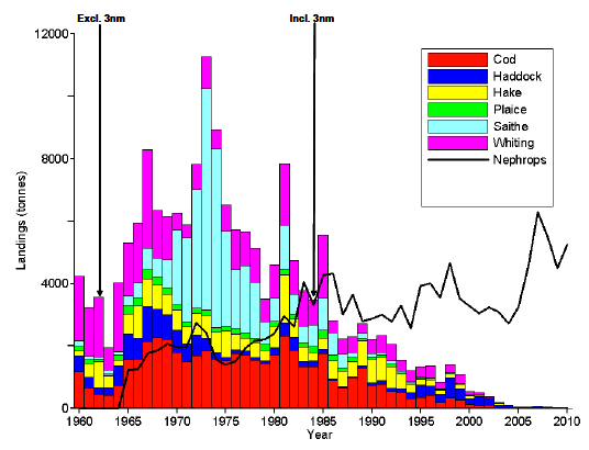
Following the opening of the Clyde to trawlers in 1962, landings rose towards a maximum in the early 1970s, and then have subsequently crashed. The removal of the 3 nm limit in 1984 resulted in the landings rising slightly for one year, before the steep decline continued. Nephrops landings, in contrast, have steadily risen since the mid-1960s.
From landings data alone it would seem that demersal fish have disappeared from the Clyde, to be replaced by Nephrops. However, this is far from the actual true picture of the health of the Clyde Sea ecosystem.
Landings of a particular species can be affected by a diverse multitude of factors, including the amount discarded, market demand for that species, legislative controls including quotas and effort restrictions. For this reason, analyses that use just landings data ( e.g. Thurston and Roberts, 2010) require significant caveats to be applied.
Survey Data
For this reason Heath and Speirs (2011) used research vessel survey data.
Since early in the 20 th century, the Scottish Government, through its Marine Laboratory in Aberdeen, have conducted trawl surveys of the Clyde fairly consistently on an annual basis. Since 1985 standardised survey methods have been used. Heath and Speirs (2011) took a statistical approach in order to reconstruct time-series describing the demersal fish community back until 1927.
Biomass
Using the survey data, they found that:
- landings of demersal fish from the Clyde in the decade 1960-1969 appear to have been 46% of the total biomass. This percentage became 99% in the decade 1970-1979, 91% in 1980-1989, 18% in 1990-1999 and 2% in 2000-2009.
- the biomass of demersal fish in the Clyde in the decades 1990-1999 and 2000-2009 was over 8000 tonnes. This is approximately twice the biomass of fish in the decade 1930-1939 (~4000 tonnes) and approximately four times the biomass in the decade 1940-1949 (~2000 tonnes).
- in the decades 1930-1939 and 1940-1949, fish smaller than the minimum landings size made up on average 11% of the total biomass, whereas in the decades 1990-1999 and 2000-2009, fish smaller than the minimum landing size made up on average 85% of the biomass.
It is quite clear there was extremely heavy exploitation of the demersal fish stocks in the Clyde in the decades 1960-1969, 1970-1979 and 1980-1989.
What is also clear is that, despite the intense fishing pressure on demersal stocks that took place in those decades, the biomass of demersal fish bounced back and in fact became greater than in the decades when fishing pressure was much lower, prior to the 1960s.
Although the total biomass of demersal fish recovered, the size of individual fish was much changed in recent decades compared to previous decades. While there was a recovered biomass, it was predominantly small fish, with >80% being smaller than the minimum landing size.
In terms of species, >70% of the small fish was whiting.
In terms of age, the small whiting have been predominantly 1 year olds at least since the late 1990s.
These observations imply that the Clyde is indeed productive. Primary production in the form of phytoplankton growth, and secondary production in the form of zooplankton growth each year supports a large biomass of young, 1 year old whiting.
A valid question is where are the spawners? What fish are reproducing and producing each year an influx of new 1 year olds?
There are no comprehensive answers to these questions. Whiting can sexually mature at age 1, although no maturity data has yet been examined for Clyde whiting. The surveys may have missed the spawning older fish. They may be in the areas the survey did not cover, including the upper Firth, the sea lochs and the coastal zone. An alternative may be that the spawning population is not within the Clyde at all, and the population of small whiting in the Clyde is created by recruitment from a distant spawning population, although this is thought to be unlikely. In order to find the answer to these questions, a survey of small fish in the Clyde is needed, focussing on sexual maturity.
Another valid question is; what happens to the older fish? Again no conclusive answers are available. However, analysis of data from the MSS observer programme suggests that the Nephrops fishery in the Clyde may be partly responsible for the current absence of older, larger fish in the Clyde.
In summary, from the estimates of biomass in the Clyde Sea the conclusions are:
- the biomass of demersal fish in the Clyde is now greater than it was in the 1930's and 1940's. In fact more than twice as great.
- but 90% of this biomass is smaller than the minimum landing size, and 72% of it is whiting.
- the demersal fish biomass has recovered from the incredibly high exploitation rates in the 1970's and 1980's.
- hence the Clyde marine ecosystem is productive. It therefore has the potential to be restored.
- however, it is in a new regime with abundant small fish and few large fish.
- in order to recover the ecosystem towards a healthy state, we need to find measures which allow large fish to survive and increase.
Using the survey data, Heath and Speirs (2011) show how the mix of fish species in the Clyde has altered. Conclusions from the study of the mix of species in the Clyde can be summarised as follows:
- Fishing has significantly altered the mix of species in the Clyde.
- The fish community has changed from an even one, with many large predator species, to one dominated by whiting and other small fish.
- Along with other indicators and tagging data, the fact that species evenness changes in the Clyde very differently than that observed in nearby waters in the Sea of the Hebrides and the Irish Sea confirms that the Clyde fish populations respond locally to fishing pressure.
-This also suggests that the Clyde can be managed separately from the Scottish west coast, with a good chance of recovery using local restoration measures irrespective of what happens elsewhere.
- Indeed, conservation measures applied to the west coast as a whole may not be sufficient for the Clyde, as it responds differently and independently from the adjacent coastal waters.
- Heath and Speirs (2011) found that there was a lag of about 20 years between the maximum average relative removal of fish from the Clyde (the Harvest Ratio peaked in about 1980) and the maximum effect on the mix of species (which reached a minimum in 2000). Such a lag is found in other indicators Heath and Speirs (2011) use of the health of the demersal fish community in the Clyde. It is typical of the complex interactions which exist in an ecosystem, and shows that we can not expect restoration measures to have immediate effects. This is particularly true if we have forced the Clyde ecosystem from one stable state to another.
Summary
There are already positive signs of change in the Clyde Sea demersal fish populations.
Since 2000 the species evenness index is increasing. In the period 1995-2004 just 4 fish species made up 95% of the biomass of Clyde demersal fish, whereas in 2005-2009 this had increased to 8. In the earlier period 87% of the biomass was whiting, while in the later period this had decreased to 72%. Possibly the most positive sign is in the size of the biomass itself, which has shown a significant increase since 1990. All of these indicators of improving conditions in the Clyde should be strong arguments supporting the prospect of a restored Clyde.
The changes in technical measures in the Clyde Nephrops fishery (change from 70mm to 80mm mesh size, introduction of square mesh panels) potentially assisted in reducing catches of small fish and may have contributed to some of the early signs of improvement recorded in this study. For this improvement to continue, further developments are required in order to allow higher proportions of medium and large size fish to escape and grow.
If we are to design optimum restoration plans for the Clyde Sea, they must be built on sound science. However, we can not wait indefinitely for the results of further scientific studies. An integrated science / policy approach is needed so that progress can be made on both fronts at the same time. To be successful, this should intimately involve all sectors of society with an interest in the future of the Clyde Sea.
It could be argued that the Clyde gives Scotland an opportunity to demonstrate leadership in terms of ecosystem restoration. It is our own inland sea, over which we have significant management control. We will be required to bring the Clyde to Good Environmental Status by 2020 by the Marine Strategy Framework Directive. Currently the Clyde would certainly fail tests such as the Large Fish Indicator, and measures of biodiversity health. A restored Clyde ecosystem could bring market advantages to the fishing industry, through ecolabelling and headline conservation achievements. However, fishing sectors will have to work together in an open and transparent way. The allocation of blame is an entirely wasteful activity. Conservationists must also accept that the Clyde is not a pristine ecosystem and never will be. It is heavily used by society for many legitimate purposes, of which food extraction is one. Focus must always be on the best way forward for all. Compromises will be possible if all stakeholders approach the challenges in a constructive way.
Gridded data sets, with a 500m by 500m resolution, of depth, sediment type and fishing activity have been created for the Clyde.
These data sets provide the following information:
Depths and Volumes
| Spatial Domain | Surface Area (km 2) | Surface Area (%) | Volume (km 3) | Mean Depth (m) | Max. Depth (m) | Min. Depth (m) | No. of Valid Grid Points |
|---|---|---|---|---|---|---|---|
| Clyde Sea | 3671 | 100% | 179 | 48.66 | 170 | 3 | 15,129 |
| Coast to 1 nm | 1206 | 33% | 36 | 30.22 | 165 | 3 | 4,971 |
| Coast to 2 nm | 1858 | 51% | 72 | 38.97 | 170 | 3 | 7,659 |
| Coast to 3 nm | 2354 | 64% | 102 | 43.40 | 170 | 3 | 9,702 |
Hence from these figures we can see that, of the 3671 km 2 of the Clyde Sea, 33%, 51% and 64% lies within 1 nm, 2nm and 3nm from the coast respectively, by area.
Habitat Types
| Gravel | Sand | Mud | ||||
|---|---|---|---|---|---|---|
| Spatial Domain | Surface Area (km 2) |
% of Clyde Total |
Surface Area (km 2) |
% of Clyde Total |
Surface Area (km 2) |
% of Clyde Total |
| Clyde Sea | 327 | 100 | 2408 | 100 | 929 | 100 |
| Coast to 1 nm | 229 | 70 | 850 | 35 | 127 | 14 |
| Coast to 2 nm | 288 | 88 | 1289 | 54 | 281 | 30 |
| Coast to 3 nm | 299 | 92 | 1584 | 66 | 471 | 51 |
From these figures we can see that 70%, 35% and 14% of all Clyde gravelly, sandy and muddy sediments, respectively, lie within 1nm from the coast. Similar figures are presented for the 2nm and 3nm zones.
In total, using 2010 VMS and FIN data, 66 vessels were found which landed Nephrops in the Clyde, and 24 landed scallops.
Fishing Activity
In relation to possible spatial management measures in the Clyde, a summary of fishing activity of the following type may be of relevance,
| Hours | Percentage | |||||||
|---|---|---|---|---|---|---|---|---|
| All Clyde Sea (Hours) |
Coast to 1 nm (Hours) |
Coast to 2 nm (Hours) |
Coast to 3 nm (Hours) |
All Clyde Sea (%) |
Coast to 1 nm (%) |
Coast to 2 nm (%) |
Coast to 3 nm (%) |
|
| ALL | 56,802 | 13,652 | 20,881 | 25,801 | 100 | 24 | 37 | 45 |
| NEP | 53,520 | 13,298 | 19,902 | 24,536 | 100 | 25 | 37 | 46 |
| SCL | 3,223 | 336 | 956 | 1,239 | 100 | 10 | 30 | 38 |
| HAD | 814 | 156 | 210 | 231 | 100 | 19 | 26 | 28 |
| COD | 60 | 17 | 19 | 19 | 100 | 28 | 32 | 32 |
From these figures we can see that of the total 56,802 fishing hours that took place in the Clyde Sea in 2010, 53,520 hours (94%) resulted in a landing of Nephrops, 3,223 (6%) hours landed scallops and just 814 hours and 60 hours landed haddock or cod respectively, most probably as by-catch in the Nephrops fishery. Hence the 66 boats which landed Nephrops from the Clyde in 2010 spent on average 810 hours fishing through the year, and the 24 scallop vessels spent, on average, 134 hours.
In terms of where fishing takes place, of the total 56,801 fishing hours of 2010, 24% occurred within 1 nm from a coastline, 37% within 2 nm and 45% within 3 nm. Therefore 55% of the total fishing activity occurred outwith 3 nm from a coast. This distribution of fishing activity is virtually identical for fishing which landed Nephrops, while it is different for fishing which landed scallops. Here, 10%, 30% and 38% of fishing activity occurred 1 nm, 2 nm and 3 nm from a coast within the Clyde Sea.
It is clear from the fishing activity maps that it is governed by the habitat types which favour the different species. Boats landing Nephrops principally target the areas where muddy sediments predominate, principally the deep basins of the Clyde, whereas vessels landing scallops target the harder sediments found around the shallower periphery of the Clyde as well as on the Great Plateau. The table below compares the percentage of each sediment type to the percentage of fishing activity in each of the spatial zones.
| Spatial Domain | Gravel | Sand | Scallops | Mud | Nephrops |
|---|---|---|---|---|---|
| % of Clyde Total |
% of Clyde Total |
% of Fishing Activity |
% of Clyde Total |
% of Fishing Activity |
|
| Coast to 1 nm | 70 | 35 | 10 | 14 | 25 |
| Coast to 2 nm | 88 | 54 | 30 | 30 | 37 |
| Coast to 3 nm | 92 | 66 | 38 | 51 | 46 |
For Nephrops the percentages of muddy sediment and fishing activity within the three spatial zones of 1nm, 2nm and 3nm are comparable. However, for scallops the percentage of fishing activity outwith the 3nm zone seems excessively large. This must take place predominantly on the Plateau. Further investigations of this anomaly are underway.
Summary
The analysis of VMS data, in conjunction with the other data layers in the CMEM databases, shows how useful this data can be to describe the current fishing practices in the Clyde and to evaluate different management options. However, more can be done.
It is possible to link actual landings to VMS pings if it is assumed each catch is evenly distributed along the vessels fishing path. This would allow summaries as above for spatial measures in terms of weight, and hence value, of landings per species per management area.
Here we have analysed the year 2010 as the most recent full year of data available to this study. However, earlier years and the more recent data can be added to look at changes over time. Similarly seasonal patterns of fishing could be examined.
Simple spatial measures involving set distances from the shore have been examined here. However, CMEM could be used to develop more complex spatial management measures based on, for example, habitat type. Temporal closures could also be examined in addition to spatial ones.
A warning should, however, be sounded. The effects of the displacement of fishing have not been touched upon here. Fishers behaviour faced with closures needs to be considered, and the impact of displaced fishing effort on other areas and habitats evaluated.
The analysis presented here only uses data from those vessels with VMS systems installed, i.e. >15m in length. Data from smaller vessels needs to be collected and analysed using CMEM.
1.8 Suggestions for Future Work
1.8.1 Clyde Hydrodynamic Model
The physical environment of the Clyde is determined by water movements driven by tide, wind and density-related forces arising from the input of freshwater within the Clyde. Additional water movement is driven by the effect of surface waves. Numerous hydrodynamic models of the Clyde have been constructed. However, as the physical environment is critical in determining the location and possible health of key sea bed habitats such as maerl beds, there is a need now for a state-of-the-art fine resolution ( e.g. 100m) three-dimensional hydrodynamic model using modern modelling technology such as the F- VCOM approach.
The picture presented here of a productive base of the food web in the Clyde is qualitative only. Although there have been numerous individual studies of aspects of the food web in the Clyde, no one quantitative overall assessment of the post-industrial (particularly after the cessation of the use of the Clyde for sewage disposal and the inclusion of the current effects of climate change) ecosystem productivity is available. The best way to integrate the physics, chemistry and biology driving the Clyde marine ecosystem in a quantifiable way is by establishing an ecosystem model of the Clyde. Some already exist, although existing models each have particular limitations and focussed uses. When assembling such a model, critical parameters will be unavailable for the Clyde and this will direct observations and experiments.
An overall ecosystem model of the Clyde Sea is needed, whether spatially-resolved or simply a sub-basin scale box-type model ( e.g. based on an ecopath-type approach), through which scientific consensus can be achieved concerning the health and productivity of the Clyde marine ecosystem.
1.8.3 Clyde Inshore Benthic Survey
There is much concern over inshore benthic habitats, especially those associated with maerl beds. It is estimated here that 10% of the sea bed of the Clyde might be able to support living maerl, although the figure may be smaller owing to constraints such as water flow and exposure. Most of these potential sites are within the 1 nm zone from the coast. In this zone the existing data sets of sea bed type, and also water depth, may be most in error. A comprehensive ground-determining acoustic survey, with associated validation using direct and indirect sampling methods, is needed of the Clyde 1 nm zone and waters out to the 20m depth contour.
1.8.4 Clyde - an MSFD Development Area?
As Europe, the UK and Scotland prepares to implement the Marine Strategy Framework Directive, the Clyde Sea offers a potentially exciting test area, where indicators and targets describing Good Environmental Status ( GES) could be developed, an integrated ecosystem monitoring scheme devised involving cross-organisational working ( i.e. Marine Scotland, SEPA, SNH) and a series of management measures implemented to take the Clyde towards GES by the target date of 2020. The Clyde offers: a pragmatic scale; a solely national management regime; a varied mix of status and pressures; diverse habitats; a representative range of stakeholders.
1.8.5 Clyde Pelagic Fish Stock Acoustic Survey
In order to estimate the current abundance and distribution of herring and sprat in the Clyde Sea, a fisheries acoustic survey should be conducted, using a multi-frequency scientific echosounder and a pelagic trawl for validation. The survey should include all areas of the Clyde Sea, as close inshore as is possible to navigate the survey vessel, and include the major loch areas (Kyles of Bute, Loch Fyne, Loch Striven, Loch Ryan) and the Clyde Estuary (to Port Glasgow). This survey should result in estimates of abundance at age for herring and sprat, and maps of their distribution.
1.8.6 Clyde Demersal Fish Survey
A comprehensive survey of demersal fish in the Clyde is required, including small fish. The survey should include a focus on the sexuall maturity and stock identification of whiting. The survey could be accompanied by increased observations of the discards of demersal fish in the Nephrops fishery.
1.8.7 Improving the Clyde Management Evaluation Model
CMEM needs to be further developed. Data sets of habitat type can be improved using finer scale surveys, and additional environmental parameters such as sea bed temperature and sea bed water flow could be added. More years of VMS data need to be included. Seasonal patterns of fishing can be examined. Landings, by species and gear type, from each grid square, as well as value of landings, can be estimated using various methods developed at MSS. A glaring lack currently is information on fishing activity by creel boats, as well as fishing activity by all vessels smaller than 15m. This could be provided by an interview-based data gathering exercise ( e.g. ScotMap, A.McLay pers. comm.).