Sectoral marine plan: islands communities impact assessment
Islands communities impact assessment for the sectoral marine plan for offshore wind energy.
Screening – is the Plan likely to have an effect on an island community which is significantly different from its effect on other communities?
Scale and likelihood of impacts
As outlined above, it is difficult to quantify the potential impacts of the Plan on all communities, including island communities, as further development is subject to a range of other considerations outside the Plan's sphere of influence. For example, it is not anticipated that all of the Plan Options included in the Final Plan will be developed to their full capacity and some Plan Options may not be developed at all. It is not possible to forecast what type of technology will be deployed within draft Plan Options.
Therefore, assessment has been undertaken using a range of scenarios and negative impacts have been assessed using a range of worst case scenarios per receptor (e.g. highest negative economic impacts in relation to displacement from fishing grounds).
Location of impacts
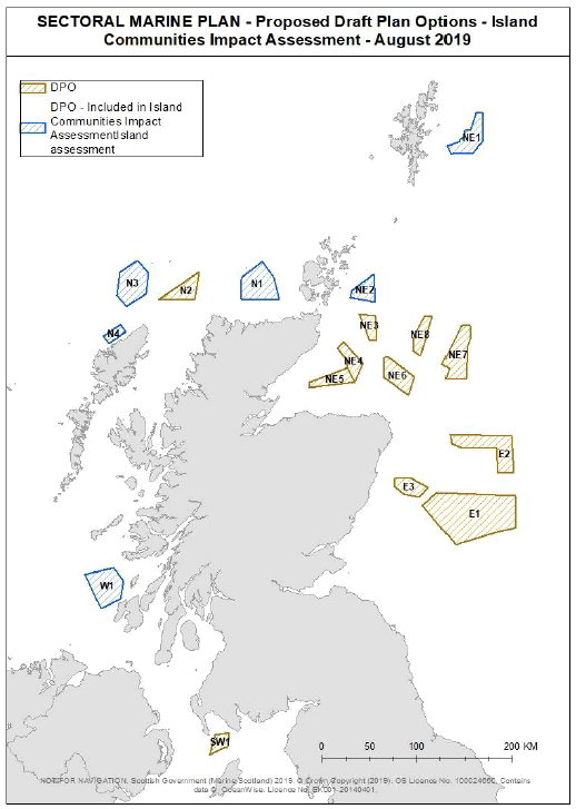
A number of draft Plan Options have been identified which are located close to island communities (as defined in Part 1 of the 2018 Act), or in areas from which island communities derive economic and other benefits. It is likely, therefore, that differential impacts on island communities may occur.
Draft Plan Options were identified within the "Scottish island marine area", as defined in Part 6 of the 2018 Act. An Islands Communities Impact Assessment ("ICIA") was therefore required to consider the impacts of those draft Plan Options located within Scottish island marine areas. Figure 1 below details the island communities considered in this assessment. These islands have been identified using the boundary figures provided by National Registers of Scotland ("NRS"). These NRS boundaries differ slightly from the definition of the Scottish island marine area included in Part 6 of the 2018 Act (which defines it as being adjacent to an island and up to 12 nautical miles ("nm") from that island when measured from the low water mark of the ordinary spring tide) due to a slightly different coastline in the available data.
Further, a precautionary approach has been taken to incorporate sites which fall within a 500 m radius of this 12 nm zone (thus incorporating sites NE1 and N1), this accounts for any data errors and to ensure that this assessment is in keeping with the spirit of the 2018 act as NE2 and N1 sit just beyond the 12 nm. Whilst site N3 falls 2 km outside the 12nm buffer zone, this site has also been included in the ICIA due to potential impacts on the island community of Lewis and to ensure that this assessment has been undertaken in a manner consistent with the spirit of the 2018 Act.
Links to the 2018 Act and improvement outcomes
The Plan will link to the achievement of the aims of the National Islands Plan. The National Islands Plan (2019) will be required to set out the main objectives and strategies for the improvement of outcomes for island communities that result from, or are contributed to by, the carrying out of functions of a public nature. These outcomes are set out at section 3(3) of the 2018 Act and include;
"a) increasing population levels,
b) improving and promoting –
(i) sustainable economic development,
(ii) environmental wellbeing,
(iii) health and wellbeing, and
(iv) community empowerment
…
f) ensuring effective management of the Scottish Crown Estate…
g) enhancing biosecurity (including protecting islands from the impact of invasive non-native species)."
These outcomes will be impacted by the development of offshore renewable energy within the Plan Options identified in the final Sectoral Marine Plan for offshore wind energy.
Development under the Sectoral Marine Plan may also link to the introduction of new powers introduced by Part 6 the 2018 Act, which allows Scottish Ministers to establish a scheme to licence development adjacent to, or within, 12 nautical miles of an island, in respect of designated island licensing areas. Areas may be designated only on application to a local authority. These powers broadly reflect the powers to licence development works which are currently available in Orkney and Shetland through private Acts of Parliament. If any such licence is granted, the person will have to carry out the activity in compliance with the terms set out by the respective local authority. Project proponents for development under the Plan will be expected to engage with potentially impacted island communities as early as possible in the development process.
The proposed location of the Sectoral Marine Plan Options are likely to have differential impacts on certain island communities. The islands duties under sections 7, 8 and 13 of the 2018 Act are therefore applicable and an islands communities impact assessment is required.
Empowering Scotland's Island Communities[4]sets out the Scottish Government's ambitions for island communities going forward and referencing the, "long-standing objective for Scottish islands, with their rich natural resources, to participate fully in the growth of renewable energy generation in Scotland." Further, the National Planning Framework prioritises the infrastructure required to "unlock the islands' renewable energy potential". This further demonstrates the link between the Sectoral Marine Plan and potential impacts on island communities. Plans and policies impacting the energy system are likely to have differential impacts on island communities by virtue of issues surrounding grid transmission and connection, fuel poverty and community ownership.