Scottish Marine Protected Areas (MPA) monitoring strategy: supporting annexes 1 to 6
These annexes provide additional context to the MPA monitoring strategy, which outlines our approach to MPA-related survey and monitoring.
Annex 5: Working with others
This annex summarises a number of recent collaborative projects undertaken to inform MPA-related assessment and reporting requirements in Scottish waters. These examples supplement those presented in the main body of the strategy and will be added to over time.
Case study 1 - Using ferries as a platform for science
Studying fan mussel larvae in the Small Isles
The fan mussel, Atrina fragilis, is the largest and rarest bivalve mollusc in Scotland, growing up to 50 cm in length. The fan mussel is listed as a Priority Marine Feature (PMF) in Scottish waters, and the only known UK aggregation is found in the Small Isles MPA. Little, however, is known about the ecology of the species and information on its early-life stages are particularly sparse.
Gathering information about the seasonality of spawning in the fan mussel required a program of sampling that posed difficult logistical challenges. The remote setting of Small Isles and the high frequency of the sampling regime meant that MSS’s dedicated survey vessels would be unable to commit to such a project. These issues were addressed in a partnership between MSS and Caledonian MacBrayne ferries, whose vessels service the Small Isles. Zooplankton samples were collected between April 2014 and September 2015 on the MV Lochnevis passenger ferry (Figure A5.1).

During the life of the project a total of 83 samples were collected using a custom built plankton sampler that was fitted to one of the ship’s seawater pumps. Fan mussel larvae were identified successfully in these samples, with the highest concentrations observed during late summer to early autumn (Figure A5.2). These findings are the first reports on the early-life stages of this Priority Marine Feature and are presented in Stirling et al. (2016).

The use of ferries as Vessels of Opportunity (VoO) from which to undertake observations of marine birds, cetaceans and basking sharks is also under consideration as part of a new citizen science programme - for further details please refer to Section 10 of the Strategy.
Reference
Stirling D.A., Boulcott P., Bidault M., Gharbi K., Scott B.E. & Wright P.J. 2016. Identifying the larva of the fan-mussel, Atrina fragilis (Pennant 1777). Journal of Molluscan Studies, In Review.
Case study 2 - Working with industry and academia to monitor Noss Head MPA
Horse mussel beds are an OSPAR Threatened and/or Declining habitat (T&D) and an Annex I habitat under the Habitats Directive. They are protected in four MPAs and a number of Special Areas of Conservation (SACs - see Cunningham et al., 2015 for further details). They are also recognised as a Priority Marine Feature (PMF) across Scottish waters. Horse mussel beds provide a habitat for commercially important species and are an important blue carbon store. The Noss Head MPA protects the largest known horse mussel bed in Scotland (and possibly the UK). The bed was first recorded during a 2010 survey undertaken on behalf of Scottish Hydro Electric Transmission PLC (SHE Transmission) (MMT, 2010), to inform High Voltage Direct Current (HVDC) transmission cable development proposals in the area. This was followed up by a survey in 2011 (Hirst et al., 2012); a collaboration between scientists from Heriot-Watt University (HWU), SNH and Marine Scotland which confirmed the presence and extent of the horse mussel bed (Figure A5.3).

This part of the coastline is relatively under-studied (e.g. to the south of the Noss Head MPA - see Figure A5.3) and the information collected by SHE Transmission continues to provide valuable evidence to inform monitoring work and to assist with survey planning. The remote location and difficult working conditions (relatively deep, strong currents and an exposed coastline) makes this area difficult to survey, especially when in-situ methods (e.g. dive surveys) are required for detailed, non-destructive assessments of this vulnerable habitat (Cook et al., 2015).
On the basis of initial sampling in 2010, the horse mussel bed was estimated to cover an area of 4.5 km2 (Moore and Roberts, 2011). This value was refined following additional drop-down video and acoustic multibeam survey work in 2011 (Hirst et al., 2012). At the time of designation in 2014, the bed was estimated to be 4.1 km2 (pink polygon on Figure A5.3 - see SNH, 2014). Additional high resolution multibeam echo sounder (MBES) survey work (plus video and still camera sampling) was carried in 2016 on behalf of SHE Transmission to inform the HVDC cable routing. The mapping products enable finer resolution estimates to be made of the extent of the bed within the MPA and have also potentially identified an additional area of horse mussel reef to the east of the main bed (~0.56 km2 - see Figure A5.5 overleaf). An SNH / Marine Scotland survey in July 2017 will determine the presence of horse mussel bed habitat here (see Annex 8 for details of the future MPA work programme).
In a parallel study, Heriot-Watt University has been working with SNH to assess connectivity of horse mussel beds in Scotland using genetic analysis. Samples from six sites were collected between 2011 and 2015 as part of a James Watt funded PhD project. The collaboration between HWU and SNH provided scope for diver sampling of the Noss Head bed in July 2016 (location indicated by a green star on Figure A5.3). Juvenile and adult horse mussels were collected from the different beds to inform a more in-depth analysis of horse mussel demographics, giving insights into reproduction and larval dispersal. The HWU divers observed juvenile gadoids and other fish on the Noss Head bed (Figure A5.4) and this has triggered follow-up studies on essential fish habitat and ecosystem services, scheduled for July 2017 in collaboration with MSS and facilitated by MASTS (the Marine Alliance for Science and Technology for Scotland).

This case study demonstrates the added value that can be obtained through collaboration with industry and academic partners. Routine survey work by SHE T continues to feed into the evidence base for the MPA and is used by SNH for survey planning (Figure A5.5).
The collaboration with HWU has improved our understanding of horse mussel connectivity and the role of the Noss Head MPA in the Scottish MPA network and beyond (Gormley et al., 2015). Sharing data between parties can help with survey planning and understanding the linkages between beds at a regional and national level, helps target monitoring effort.

References
Cook, R., Fariñas-Franco, J.M., Gell, F.R., Holt, R.H., Holt, T., Lindenbaum, C., Porter, J.S., Seed, R., Skates, L.R., Stringell, T.B. & Sanderson, W.G. 2013. The substantial first impact of bottom fishing on rare biodiversity hotspots: a dilemma for evidence-based conservation. PloS one, 8(8), p.e69904.
Cunningham, S., Chaniotis, P.D., Gillham, K. & James, B. 2015. Assessment of the adequacy of the Scottish MPA network for MPA search features: summary of the application of stage 5 of the MPA Selection Guidelines post consultation. Assessing risk to Scottish MPA search features at the MPA regional scale. Final report produced by the Joint Nature Conservation Committee, Scottish Natural Heritage and Marine Scotland for the Scottish Marine Protected Areas Project. Available from - http://www.snh.gov.uk/docs/A1567699.pdf
Gormley, K., Mackenzie, C., Robins, P., Coscia, I., Cassidy, A., James, J., Hull, A., Piertney, S., Sanderson, W. & Porter, J. 2015. Connectivity and dispersal patterns of protected biogenic reefs: Implications for the conservation of Modiolus modiolus (L.) in the Irish Sea. PloS one, 10(12), p.e0143337.
Hirst, N.E., Clark, L. & Sanderson, W.G. 2012. The distribution of selected MPA search features and Priority Marine Features off the NE coast of Scotland. Scottish Natural Heritage Commissioned Report No. 500. Available from - http://www.snh.org.uk/pdfs/publications/commissioned_reports/500.pdf
MMT. 2010. Marine Survey Report: Project Shetland HVDC Cable Link - HUB - Geophysical Survey. Report by MMT for Scottish and Southern Energy, MMT Project number 100711, November 2010.
Moore, C.G. & Roberts, J.M. 2011. An assessment of the conservation importance of species and habitats identified during a series of recent research cruises around Scotland. Scottish Natural Heritage Commissioned Report No. 446. Available from - http://www.snh.org.uk/pdfs/publications/commissioned_reports/446.pdf
SNH. 2014. Scottish MPA Project. Assessment against the MPA Selection Guidelines. Noss Head Nature Conservation MPA. September 2014. Available from - http://www.snh.gov.uk/docs/A987879.pdf
Case study 3 - Working with sea anglers to monitor common skate in a coastal MPA
The Loch Sunart to the Sound of Jura MPA originated from a third-party proposal submitted by the Scottish Sea Angling Conservation Network[62] (SSACN), who also run the Scottish Shark Tagging Programme (SSTP). Common skate tagging records (capture-mark-recapture) collected by recreational sea anglers as part of the SSTP were combined with historical records from Glasgow Museum and the UK Shark Tagging Programme to support the case for designation.
Sea anglers also worked with scientists from MSS to track movements of common skate in key parts of the site (using an acoustic array) and to gain an insight into the depth zones used by individual fish using detailed data storage tags (Neat et al., 2014). The MPA was subsequently designated in 2014 and new fisheries management measures were introduced in 2016[63].
Since 2016, recreational anglers and local creel fishermen have been helping SNH and MSS implement follow-on studies[64] to help refine initial estimates of survival rates for the common skate within the site (setting a baseline against which to determine the effectiveness of the new fisheries management measures). The work has involved the use of PIT tags, tiny electronic tags which are invisible externally like those used for pets, as well as acoustic tags combined with a more sophisticated detection array to confirm how much time the fish spend in different parts of the MPA. Receivers were positioned in the Sound of Mull, the Firth of Lorn, Loch Linnhe, the Lynn of Lorn and Loch Etive. The receivers record each time an individual fish passes within range. Sea anglers have been taught to PIT tag and have been provided with relevant equipment (including scanners to allow caught fish to be checked for existing tags) to enable this new monitoring method to be rolled out across the MPA (and beyond). Anglers have also been provided with tarpaulins so that they can lift skate safely back into the water after capture (see Figure A5.6).

SNH have also been discussing a proposal from the Scottish Association for Marine Science (SAMS) to develop a photo-ID library and database for skate in Scotland. Scientists at SAMS have been analysing a set of 400 photos provided by a skate charter skipper as part of an initial feasibility study. If successful the project will be rolled out further, collecting historical and new photos from anglers. SSACN have offered their support in reaching their members to support this exciting new project. A series of example images illustrating six recaptures of the same fish are shown in Figure A5.7 (overleaf).

References
Neat, F., Pinto, C., Burrett, I., Cowie, L., Travis, J., Thorburn, J., Gibb. F. & Wright, P.J. 2014. Site fidelity, survival and conservation options for the threatened flapper skate (Dipturus cf. intermedia). Aquatic Conservation: Marine and Freshwater Ecosystems. Available from - http://dx.doi.org/10.1002/aqc.2472
SNH & JNCC. 2012. Advice to the Scottish Government on the selection of Nature Conservation Marine Protected Areas (MPAs) for the development of the Scottish MPA network. Scottish Natural Heritage Commissioned Report No. 547. Available from - http://www.snh.gov.uk/docs/A990246.pdf
Case study 4 - Contingency sampling - UK-wide agency collaboration
Scottish nearshore waters include sheltered sea lochs, embayments and firths, which provide useful contingency areas for vessels on offshore research cruises. For example, in December 2015 Cefas were carrying out work in Northern North Sea but poor weather conditions confined the vessel to coastal areas. Communication with SNH identified a series of seabed habitat sampling locations to improve general coverage within the Moray Firth. Positions were sent through directly to the vessel for video and grab sampling. Cefas worked through the locations (Figure A5.8) and infaunal samples and seabed imagery data were supplied to SNH free of charge.
SNH commissioned analysis of the video and grab samples and the results of this work have been published in Moore (2016) [Moray Firth video samples], Axelsson et al., (2017) [Southern Trench grab samples] and Moore, 2017 [Southern Trench video samples]. The products of this partnership have improved our understanding of the distribution of seabed habitat features within the existing and proposed protected areas. The 2015 data has informed the development of new predictive mapping products for both areas (Natural Power, in prep.) which will inform future site management discussions.

Samples revealed records of potential Sabellaria spinulosa reefs off Fraserburgh (Figure A5.9) and build on 2014 records from survey work undertaken in this area in relation to a development proposal (as part of an environmental impact assessment - survey records were supplied to SNH on request). Deep sandy mud in the north-west corner of the MPA proposal supported a moderate density of megafaunal burrowers including Nephrops norvegicus and Pennatula phosphorea (Moore, 2017).
Sabellaria spinulosa reefs are an OSPAR Threatened and/or Declining habitat (T&D) and an Annex I habitat under the Habitats Directive. The information obtained through this example of collaboration between agencies, and from industry in relation to development casework, extends the known range of this feature in UK waters.
Defining aggregations of S. spinulosa as a ‘reef’ is not always straightforward (although guidance is provided by Hendrick and Foster-Smith, 2006). Therefore additional sampling off Fraserburgh will be undertaken in 2017 to improve our understanding of the extent of this habitat (refer to Annex 8 for a forward look at the Scottish MPA-related survey programme).

References
Axelsson, M., O’Dell, J. & Dewey, S. 2017. Infaunal and PSA analyses of benthic samples collected from South Arran MPA, Lochs Duich, Long and Alsh MPA and Southern Trench MPA proposal. Scottish Natural Heritage Commissioned Report No. 946. Available from - http://www.snh.org.uk/pdfs/publications/commissioned_reports/946.pdf
Hendrick, V.J., & Foster-Smith, R.L. 2006. Sabellaria spinulosa reef: a scoring system for evaluating ‘reefiness’ in the context of the Habitats Directive. Journal of the Marine Biological Association of the United Kingdom, 86(04), 665-677. Available from - http://www.emodnet-seabedhabitats.eu/pdf/Hendrick %282006%29 Sabellaria spinulosa reef - a scoring system.pdf
Moore, C.G. 2016 Biological analysis of underwater video and infaunal data from surveys of the Moray Firth SAC. Scottish Natural Heritage Commissioned Report No. 940. Available from - http://www.snh.org.uk/pdfs/publications/commissioned_reports/940.pdf
Moore, C.G. 2017. Biological analyses of underwater video from ongoing monitoring and research cruises in Lochs Sunart, Etive and Alsh, sea lochs off South Skye, the Sounds of Barra and Arisaig and around the Southern Trench. Scottish Natural Heritage Commissioned Report No. 959. Available from - http://www.snh.org.uk/pdfs/publications/commissioned_reports/959.pdf
Natural Power Consultants Ltd. 2017. Predictive mapping of seabed features within selected Special Areas of Conservation and Nature Conservation MPAs in Scottish territorial waters using available datasets. Scottish Natural Heritage Commissioned Report. No. 980. Available from - http://www.snh.org.uk/pdfs/publications/commissioned_reports/980.pdf
Case study 5 - Volunteers & long-term monitoring - Canna seabird studies
Long-term studies on seabirds are something of a rarity. Across the World, there are only a handful of studies that have seen over 40 years of sustained effort.
The Canna seabird study which began in 1969, continues to reveal new information on seabirds. It is one of three key monitoring sites in Scotland alongside Fair Isle and the Isle of May. Every year a small, dedicated team visits the island to study its seabirds. The team of volunteers come from a range of backgrounds, and all have a passion for seabirds.
The information was vital when it became apparent that rats were having a significant effect on Canna’s seabirds. It is heartening to see puffins, razorbills and guillemots returning to breeding in areas that rats had effectively extirpated them from.
Advances in technology have allowed seabirds to be tracked, using miniature-tracking devices attached to guillemots, razorbills, kittiwakes and fulmars. These are beginning to show some fascinating results on where our seabirds go in the winter months and will hopefully help others conserve seabirds further afield by identifying important sites at sea.
More information on the Canna Seabird Study can be found at:
Canna Seabird Studies Report 2015[65]
Case study 6 - Community based seabed monitoring in Wester Ross
Coastal community groups have great potential for undertaking marine monitoring. They are able to access their local waters year-round, and have useful skills, knowledge and motivation. Bringing communities into the data collection process also has the potential to increase trust in decision-making. To deliver on this potential there needs to be guidance and training from scientists and an understanding in communities about what constitutes usable evidence.

The University of Glasgow has been working with the community group Sea Change to help them develop a community-based monitoring programme for the Wester Ross MPA. So far this has resulted in the constriction of prototype drop camera systems, which can also be used as baited remote underwater video systems (BRUVS). The Sea Change group has been carrying out pilot surveys, including experimenting with camera drops from kayaks.
Case Study 7 - Working with Universities to examine benefits to commercially fished stocks
A further aspect of monitoring the protected seabed habitats within the MPAs is to understand the extent to which associated fish communities may be benefiting. For example, studies have shown that habitats recovering from physical disturbance become more structurally complex, which makes them more attractive to fish for feeding and shelter (and this may be particularly important for juveniles). Where these fish are of commercial interest, then there is the potential for protection of seabed habitats within MPAs to contribute positively to the sustainability of fisheries.
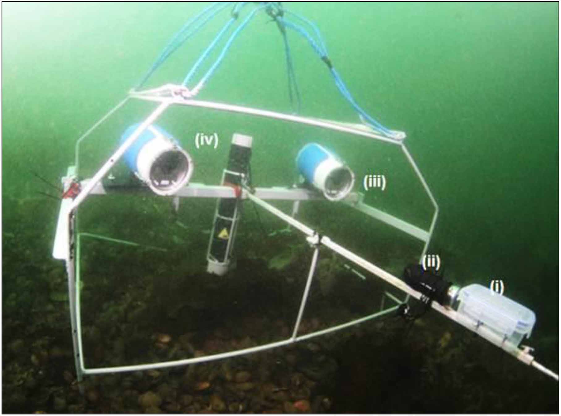
The University of Glasgow carried out photographic surveys of juvenile gadoids within the South Arran MPA in 2013, 2014 and 2016. The methods used were Stereo Diver-Operated Video (SDOV) transects and Stereo Baited Remote Underwater Video (SBRUV) deployments (see Elliott et al., 2016; & Elliott et al., in press for further details). These studies identified the seabed types with which different gadoid species are associated and found that, within each seabed type, fish abundance is higher where there is higher benthic biodiversity. In collaboration with the University of Strathclyde, a predictive seabed map was created using the camera images. As well as developing our understanding of the ecology of important commercial species, these surveys provide a permanent and quantitative record of the state of the MPA around the time of its designation and the implementation of management measures.
* This work was funded by the Scottish Government ClimateXChange Centre of Expertise, Marine Scotland Science, Scottish Natural Heritage and NERC.
References
Elliott, S.A.M., Ahti, P.A., Heath, M.R., Turrell, W.R. & Bailey, D.M. 2016. An assessment of juvenile Atlantic cod Gadus morhua distribution and growth using diver operated stereo-video surveys. Journal of Fish Biology, 89: 1190-1207. doi:10.1111/jfb.12998.
Elliott, S.A.M., Heath, M.R., Turrell, W.R. & Bailey, D.M. (in press). Juvenile gadoid habitat and ontogenetic shift observations using stereo-video baited cameras. Marine Ecological Progress Series. doi: 10.3354/meps12068.
Contact
Email: marine_biodiversity@gov.scot