Scottish blue carbon action plan
Plan setting out how consideration of blue carbon habitats is being integrated into marine policies and priority actions to address key evidence gaps.
4. Blue carbon habitats and actions
This section outlines each of the four blue carbon habitats under consideration in turn: saltmarsh, seagrass, seabed sediments, and kelp and other seaweeds. For each habitat, the following information is provided: a brief description of how the habitat functions as a natural carbon store; a map of known distribution; an outline of the current pressures on the habitat and its vulnerability; information on the next steps and priorities; and a list of actions that will be undertaken by the Scottish Government and partners.
The actions for each habitat are focused on addressing evidence gaps in order to support objective 2: to continue to build the evidence base for blue carbon habitats to address key knowledge gaps and support policy development, implementation, and evaluation.
4.1. Saltmarsh
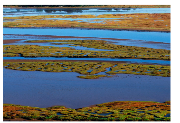
Saltmarsh is a coastal habitat located in sheltered areas, regularly flooded by saltwater, and populated by salt-tolerant plants. During photosynthesis, saltmarsh plants take up CO2 from the atmosphere, some of which is stored in plant matter and subsequently becomes buried in the low-oxygen conditions of the waterlogged soils found in these coastal wetlands. Organic carbon from other sources can also be washed into saltmarsh via rivers and estuaries and become buried over time. It is estimated that Scottish saltmarsh stores around 1,150,000 tonnes of organic carbon and around a further 4,385 tonnes per year are added.[10]
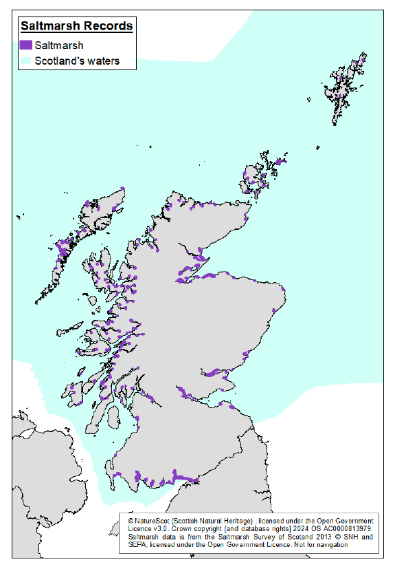
The last national survey of saltmarsh in Scotland, in 2010-2012, recorded 5,840 hectares. The actual extent is likely to be greater as the 2010-2012 survey only included saltmarsh over 3 hectares in area. Some areas of saltmarsh (as well as seagrass beds) have also been surveyed more recently as part of local projects, such as the Solway Coast and Marine Project.[11] Additionally, saltmarsh is a dynamic habitat and there may have been growth (accretion) and loss (erosion) since the last national survey. Figure 1 shows the known distribution of Scottish saltmarsh.
The relatively small current total area and geographical range for saltmarsh across Scotland imposes a natural limit on potential expansion and restoration, which in turn limits the potential for blue carbon additionality that human intervention can bring about. Therefore, while protecting existing natural stores of carbon in saltmarsh is important to prevent avoidable loss of carbon, the potential for climate change mitigation through the expansion or restoration of saltmarsh habitat is more limited.
Vulnerabilities and pressures
Saltmarshes face a number of threats and pressures, and the total extent of saltmarsh in Scotland has declined over hundreds of years of human activity. Damage and disturbance to saltmarsh habitat resulting from these pressures can impact on its capacity to store carbon. Pressures on saltmarsh include:
- land claim and encroachment for human use, particularly for agriculture, industry, and urban expansion
- overgrazing by cattle and sheep that can cause soil compaction, loss of vegetation, and damage to root structure (increasing erosion risks)
- pollution and waste disposal in coastal waters[12]
Saltmarsh next steps
Saltmarsh has the most developed evidence base compared to the other blue carbon habitats and is recognised for its potential to contribute to climate change mitigation. Steps can be taken to enhance the blue carbon storage potential of Scottish saltmarsh, which can be achieved by increasing the extent of saltmarsh, through the removal of pressures (passive restoration) and the creation of new habitat or restoration of previously existing habitat (typically by managed realignment of the coast). Existing policies including the National Marine Plan and National Planning Framework encourage consideration of impacts of development activities on the environment and spatial protections in the MPA network guide management of activities to help reduce pressure on saltmarsh and contribute to passive restoration.
Nature funds will continue to support efforts to enhance and restore habitats, as well as to support establishing mechanisms to attract private finance. The upcoming Saltmarsh Code at the UK level is expected to help encourage further private investment as well. Local community and partnership-based approaches, including citizen science, are also an important part of nature regeneration and are a critical part of ensuring local support and engagement (for an example, see Box 3 on saltmarsh and seagrass along the Solway Firth in the following section). Community engagement will be encouraged as part of the wider approach to becoming nature positive.
Important saltmarsh evidence gaps remain and must be addressed to ensure that policies can be effectively targeted. In particular, there is a need to further refine and standardise how blue carbon additionality by saltmarsh is quantified to ensure that data are being collected accurately and consistently and to develop cost-effective means to map and monitor saltmarsh nationally. Further, restoration efforts need to be supported by work to identify suitable sites. Mapping and modelled data can guide site identification and should be used alongside other tools and ground truthing. Addressing these gaps will help inform consideration of saltmarsh inclusion in the UK greenhouse gas inventory. This will also strengthen the evidence base for the management, protection, and restoration of saltmarsh by enhancing the recognition of its natural carbon storage, alongside the well-recognised ecological and biodiversity benefits that have already driven policy on saltmarsh.
The Scottish Government’s efforts to improve the evidence base are therefore focused on improving understanding of the extent, condition, vulnerability, and emissions factors of saltmarsh to ensure that policies are applied effectively, as well as supporting the identification of suitable sites for practical action.
As the evidence base is further developed, the Scottish Government will also continue to work collaboratively with partners in the UKBCEP to advance the potential inclusion of saltmarsh in the UK greenhouse gas inventory. Actions to address evidence gaps outlined below will contribute to this work and help guide restoration efforts.
Actions
1. Monitor greenhouse gas fluxes on Scottish saltmarsh. At the end of 2024, the Scottish Government and NatureScot launched a project to set up a Scottish saltmarsh greenhouse gas flux tower to monitor carbon dioxide. This project will run for multiple years and will contribute to a broader UK network of towers, providing insights into greenhouse gas emissions at a Scottish site. Following procurement of the flux tower, partners will work together to identify a suitable site and complete installation. The work is being led by the Scottish Government as part of the UKBCEP that aims to support the inclusion of saltmarsh habitat in the UK greenhouse gas inventory. At the end of each year, the findings of the project will be reviewed and consideration given to its longer-term future, including scope for expanding the network to other Scottish saltmarsh locations.
2. Improve maps of saltmarsh habitat extent. Work is being trialled on the potential to develop a semi-automated model, utilising remote sensing of topography and vegetation, to support efforts to map the extent of Scottish saltmarsh in a cost-effective manner. Initial work has been progressed by JNCC and NatureScot. Based on the outcome of the trial, further consideration will be given to the potential role of Earth Observation and other remote-sensing techniques towards future mapping and monitoring of Scottish saltmarshes at a range of spatial scales.
3. LiDAR Mapping. The Scottish Government will undertake a programme of LiDAR remote sensing mapping that will begin in 2025. The data will be hosted on Scotland’s spatial data portal. As part of this programme, coastal surveys will be timed to coincide with low water spring tides to capture intertidal areas. The work will help to define the current extent of key coastal habitats and landforms (including saltmarsh) and will inform understanding of future coastal change. This collection of the first ever full LiDAR map of Scotland was announced by the First Minister at the NFU Scotland AGM on the 7 February 2025. This information will be used to improve the maps on saltmarsh habitat.
4. Understand saltmarsh health and pressures. Work will be undertaken to improve understanding of the health of saltmarsh and the pressures on it in order to inform better management practices. This will be led by NatureScot in 2026/27.
5. Identifying sites for habitat restoration and creation. Areas which may be suitable for saltmarsh restoration/creation through activities such as managed realignment or regulated tidal exchange, will be identified as part of broader work to identify potential accommodation space for the adaptation of coastal habitats in response to coastal change. This will incorporate recent academic review of how saltmarshes may respond to accelerating sea-level rise. NatureScot will undertake initial work in 2025/26 and will be supported by the Scottish Government. Outputs from the initial work will then be used to support more comprehensive opportunity mapping for saltmarsh restoration, which may include an assessment of overlap with existing infrastructure, pressures, and activities that might hinder restoration. The outputs can then be used to help prioritise funding decisions for saltmarsh restoration work.
4.2. Seagrass
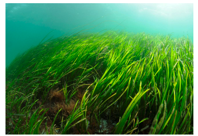
Seagrass is a flowering plant found in intertidal and subtidal areas in inshore waters, which sometimes spread across large meadows. It takes up dissolved atmospheric carbon dioxide from seawater during photosynthesis, locking away some of that carbon as organic matter within its plants. As seagrass beds develop, dead seagrass is incorporated into the underlying sediment. Small particles of organic carbon from other sources that are floating in the water column can also become trapped in seagrass beds and become buried in the underlying sediment as well.
There is a high degree of uncertainty around the amounts and rates of organic carbon taken up and stored by Scottish seagrass. This is due in part to incomplete habitat mapping, the limited research evidence available, and a wide range of estimates depending on the location of the site and methods used. The current best estimate is that Scottish seagrass beds store around 165,000 tonnes of organic carbon, which is based on a mix of limited on-site sampling and modelling. It is also estimated that around 1,000 tonnes of organic carbon is added per year, though this is based on global estimates that may be skewed to more productive seagrasses found in warmer climates.[13]
The total area of mapped seagrass beds is estimated to be 1,504 hectares. However, this is likely to be an underestimate, as not all seagrass beds are mapped.
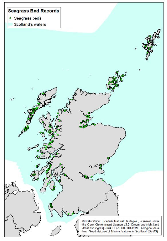
Figure 2: Snapshot of seagrass distribution, based on current understanding. (Please note that distribution maps are regularly updated on NMPi)
Vulnerabilities and pressures
As a blue carbon habitat that spans intertidal and subtidal zones, seagrass beds are subject to a range of pressures from both land and sea. Scottish seagrass beds have experienced significant historical decline, which has been observed in both Scottish waters and globally. While there are some limitations to known habitat extent due to incomplete historic mapping, it is estimated that at least 44% of seagrass beds have been lost since 1936.[14] This may have been caused by:
- the seagrass wasting disease Labyrinthula
- reduced water quality, including from agricultural and industrial run-off and over-fishing of oysters (which help improve water quality)
- increased turbidity (cloudiness) in the water, which can also be caused by run-off from agriculture and industry, from trawling and dredging, and from coastal erosion and storms
- direct damage from human activities, such as fishing trawls, dredges, anchorages and moorings, and coastal and marine construction
Wider work has also been undertaken on understanding the source-to-sea flows and implications for addressing the twin nature and climate crises, highlighting the importance of also recognising land-based processes and systems alongside marine activities when focusing on coastal water environments.[15] As highlighted in action 7 below, further work is underway on causes of decline of seagrass, including pollution and other land-based run-off that will directly inform restoration efforts.
Seagrass next steps
Currently, the estimates of blue carbon stock and burial by Scottish seagrass are relatively small and based on limited evidence, and efforts to restore seagrass in some locations have also had varying success rates. While these uncertainties impact on the potential role of seagrass restoration in relation to climate change mitigation, the biodiversity benefits are well recognised and have underpinned many existing policies. The National Marine Plan requires consideration of reducing human pressure and safeguarding of ecosystem services in decision-making, as well as consideration for seagrass as a PMF. Seagrass is also recognised as a protected feature in many MPAs, which contribute to pressure management for these habitats. Proposed management measures for fishing activity will provide further contribution to protection for seagrass both in the MPA network and at key biodiversity locations outside of the network.
Upcoming restoration efforts as part of the Scottish Government’s biodiversity priorities provide opportunities to monitor and measure carbon uptake and storage in restored and donor sites, helping to add much-needed Scottish data to current estimates that may be skewed by international findings from more productive tropical seagrass habitats. This data will inform the next steps for seagrass, including whether it would be beneficial to undertake more comprehensive national assessments focused on carbon storage and burial rates.
Local community and partnership-based approaches, including citizen science, are also an important part of nature regeneration and are a critical part of ensuring local support and engagement (for an example, see Box 3 on saltmarsh and seagrass along the Solway Firth). Community engagement will be encouraged as part of the wider approach to becoming nature positive. Nature funds will continue to be used to enhance and restore seagrass habitats.
As the evidence base around seagrass is enhanced, the Scottish Government will continue to work collaboratively with partners in the UKBCEP as part of the longer-term ambition to explore the inclusion of seagrass in the UK greenhouse gas inventory. However, as a number of uncertainties remain around seagrass blue carbon evidence, it is recognised that the potential inclusion of seagrass in the inventory remains a long-term objective.
Actions
6. Baseline survey of carbon storage in new seagrass projects. Guidance and procedures to baseline survey carbon capture in seagrass restoration projects and donor sites will be produced and trialled on the projects supported by over £2 million investment by SSEN Distribution via SMEEF over the next 4 years. This work will help to standardise monitoring of carbon storage in seagrass projects and will enhance understanding of the contribution seagrass can make to climate change mitigation. It will be led by the Scottish Government, starting in 2025/26. Further, following initial findings, consideration will be given to undertaking a wider assessment of Scottish seagrass to improve our understanding of seagrass extent, condition, and blue carbon potential across Scotland.
7. Supporting habitat restoration and creation. Habitat suitability modelling and characterisation of marine regions for seagrass restoration potential will be progressed to assist and identify areas which may be suitable for seagrass restoration, including consideration of future climate change. This work will consider recent research on the causes of seagrass decline, including land and marine derived pollution, in Scottish waters and will inform the development of opportunity maps to help guide resources and restoration efforts to areas where success is most likely. This opportunity mapping is not intended to be prescriptive, but will act as tool to help guide and support where restoration might be possible. This work is being taken forward by NatureScot in 2025/26.
8. Understanding existing and proposed protections. Work is underway to assess the extent to which existing protected areas and current and proposed management measures for fishing activity may reduce pressures on blue carbon within known Scottish seagrass beds (as well as on seabed sediments) and to highlight the complexities involved. This is being led by NatureScot in 2025/26.
Box 3: Solway Coast and Marine Project - Innovation in Restoration
The Solway Coast and Marine Project - Innovation in Restoration, led by Dumfries and Galloway Council, delivered by Solway Firth Partnership, recognises the untapped economic and social potential of Scotland’s coasts and seas. The project will undertake key strategic interventions to restore and expand coastal, intertidal and marine habitats (saltmarsh, sea grass and native oysters) in support of key economic fishery species, water quality, key coastal tourism locations, climate mitigation, adaptation & carbon sequestration.
Development work undertaken so far includes baseline mapping of intertidal seagrass, Zostera spp. beds; coastal hydrodynamic research; saltmarsh opportunity mapping to identify suitable potential locations for inland expansion; and in vitro propagation trials of Zostera spp. for potential seagrass restoration at the University of Edinburgh.
Solway Firth Partnership is working to share knowledge with academics, charities, and industry, providing demonstrations of new procedures and technologies allowing further rollout of successful interventions at scale. The ambition is to see the Solway Firth as a thriving healthy sustainable ecosystem, where healthy natural capital provides ecosystem services that support sustainable communities, builds the Wellbeing Economy, contributes to Community Wealth Building and the just transition to Net Zero, by working with local communities and partners.
4.3. Seabed sediments
Natural, long-term storage of organic carbon in marine environments takes place through the accumulation and burial of organic matter in seabed sediments.
Sediments are not evenly distributed across the seafloor and there is a large variety of sediment compositions, types, and structures. This includes, for example, mudflats, sandflats, tidal flats, deep sea muds, and burrowed mud. Carbon in sediments is derived from a variety of marine and terrestrial sources, which is transported through the marine environment and sometimes carried offshore by currents. While this process does not directly sequester additional carbon from the atmosphere and so cannot be used to contribute to achieving net zero, the sediments themselves hold vast stores of organic carbon. This carbon may be vulnerable to loss from human pressures that could then make climate change worse.
The nature of seabed sediments being heterogeneously spread across very large areas of Scotland’s shelf seas and sea lochs, and challenges associated with taking samples at sea, mean that mapping and estimating carbon storage is difficult and there are large uncertainties in current estimates. There have been some recent improvements to mapping of marine sedimentary carbon, including the Blue Carbon Mapping Project funded by WWF, the Wildlife Trusts, and RSPB,[16] and further work is ongoing on more detailed mapping, including to provide open access layers and in specific areas of higher marine traffic such as the Firth of Clyde.
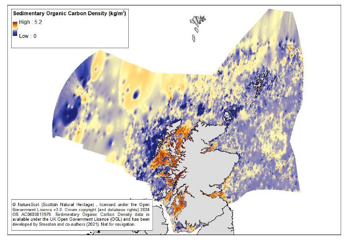
Scotland’s sea floor and shelf seas cover an area of 45.6 million hectares, which is around six times the size of Scotland’s land area. It is estimated to hold around 357 million tonnes of organic carbon within the top 10 centimetres. Within this overall expanse, Scottish sea lochs are significant blue carbon hotspots, holding around double the density of organic carbon compared to most seabed sediments. Despite only making up 260,800 hectares, these fjordic sea lochs hold 3.9 million tonnes of organic carbon in the top 10 centimetres of sediment.[17] Other areas of Scotland’s seas, such as some coastal inlets, have also been identified as blue carbon hotspots, based on the density and quality (expressed as a measure of reactivity) of the organic carbon found there.
Despite growing knowledge about the vast store of carbon in marine sediments, the stores themselves are not static, and the amount of organic carbon being added to or lost from these sediments each year is far more uncertain. Organic matter from marine animals and plants, and washed into the sea from rivers, sinks down through the water column and settles onto the seabed where a range of biological, chemical and physical processes act to influence its long-term burial and storage. A preliminary estimate has calculated a total burial capacity of 7 million tonnes of organic carbon per year in Scottish waters[18]. A separate estimate has suggested 84,000 tonnes per year are buried within sea lochs specifically, though these rates are expected to vary depending on location and the type of sediment.[19]
Further research is also required to address the uncertainties around estimates of carbon burial. This includes improving understanding of the flow of carbon from source to sea, the relative contribution of different sources of carbon such as peatland or agricultural soil erosion (i.e. terrestrial sources) or marine animals, plants or algae (marine sources) and how this might change over time.
Figure 3 shows the distribution and density of organic carbon in Scottish sea sediment. The colour gradient highlights the concentrations of organic carbon along the west coast in particular, with higher concentrations shown in warmer/redder shading.
Vulnerabilities and pressures
Disturbance to seabed sediments can be caused by a variety of activities, such as bottom trawling, cable and pipeline construction, and offshore marine energy development. The most widespread disturbance on seabed sediments comes from bottom trawling, due to frequency and extent of contact with the seabed.[20] This process, which drags weighted nets across the seafloor, causes the top layers of sediment to become resuspended in the water column. This potentially exposes previously buried organic carbon to remineralisation in oxygenated bottom waters before it resettles on the seabed, where it may undergo burial again. Research suggests that sea loch and near-shore sedimentary organic carbon may be more vulnerable to disturbance because the organic matter in these sediments is more reactive (i.e. it breaks down more easily).[21] However, the full impact of bottom trawling and the eventual fate of organic carbon remains poorly quantified and is an area of active research. Current studies focus on the fate of organic carbon as it undergoes repeated transport, resuspension and deposition following disturbance; the simultaneous effects of trawling mixed with biological change; and, in particular, whether any carbon is returned to the atmosphere in the form of CO2.
Seabed sediments next steps
Understanding of the potential role of seabed sediments as a blue carbon habitat is still at a relatively early stage, and managing seabed carbon has only recently emerged as an important driver for policy. However, many areas of higher density seabed carbon (sometimes referred to as blue carbon hotspots) are already designated as protected features within the MPA, for example as burrowed mud (carbon rich muds serve as suitable habitats for mud-dwelling creatures). Existing data shows some overlap between burrowed mud and known blue carbon hotspots. Burrowed mud, as well as other seabed features, is also designated as a PMF, so must be given consideration in decision-making in line with National Marine Plan requirements. Key policies and measures aimed at safeguarding these habitats will continue to be underpinned by existing obligations related to nature protection and restoration, as well as achieving or maintaining good environmental status of marine waters. At the same time, efforts will focus on enhancing understanding of seabed sediments as a natural carbon store and how this interacts with human activities, including within the MPA network. Proposed management measures for fishing activity will provide additional protection to specific seabed habitats, though these have been primarily driven by the requirement to protect biodiversity. Further work will be undertaken to examine how existing and proposed management measures contribute to reducing pressures on blue carbon stores (see action 12).
The Scottish Government’s main focus is to address evidence gaps and to better understand the vulnerabilities of these habitats to a range of pressures and to evaluate how both existing and proposed management measures may protect these habitats. As the understanding of the impact of human activities on the carbon stored in seabed sediments is enhanced, careful consideration will be given to whether further policy actions may be required to help reduce avoidable losses of carbon from these long-term stores.
Actions
9. Modelling and mapping the vulnerability of sedimentary carbon. Research to improve understanding of the vulnerabilities of sedimentary carbon to disturbance from bottom trawling is underway. Having started this work in 2024, the Scottish Government Marine Directorate is working with partners to support three projects focused on: (i) quantifying the impact of natural and human-based disturbance; (ii) mapping and quantifying seabed organic carbon density, reactivity, and age; and (iii) mapping and quantifying seabed disturbance from human activities. These projects are due to report preliminary findings in 2025.
10. On-site research to assess pressures on sedimentary carbon. Building on the findings from the research projects of Action 9, the Scottish Government will lead a project later in 2025/6 to conduct on-site sampling to further enhance understanding of sedimentary carbon vulnerability and the impact of bottom disturbance in blue carbon hotspots. This project will provide new information to help assess how pressures on the most vulnerable seabed carbon stores can be managed.
11. Scaling up findings to all Scottish seabed sedimentary carbon. Methods to scale up the findings from Actions 9 and 10, along with the results of currently published studies, across Scottish seas will be explored. A national-scale assessment of the potential impacts on sedimentary carbon from seabed disturbance will be attempted. This work will be led by the Scottish Government and will take place in 2026/27 and 2027/28.
12. Understanding existing and proposed protections. Work is underway to assess the extent to which existing and proposed management measures for fishing activity are reducing pressures on blue carbon within seabed sediments (as well as on seagrass beds) and to highlight the complexities involved. This work is being led by NatureScot in 2025/26.
4.4. Kelp and other seaweeds
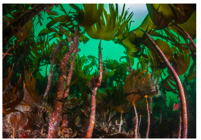
Kelp and other seaweeds are macroalgae that grow on underwater rocks, often found in coastal waters. Kelp and other seaweeds do not have a root system and instead anchor onto hard surfaces. Therefore, while photosynthesis converts CO2 from the atmosphere via ocean surface uptake and stores it within the living biomass of kelp, the ultimate fate of this organic carbon depends on what happens to the kelp detritus produced. Some kelp detritus may end up in seabed sediments that are adjacent to kelp forests, or it may drift into the deeper waters and become buried. However, much of the detritus ends up decomposing at sea or is washed ashore. While these processes contribute to the ocean carbon and nutrient cycles, there is limited evidence available to quantify how kelp and other seaweeds contribute to long-term organic carbon storage in marine sediments. There is therefore a high level of uncertainty about how kelp contributes to long-term climate change mitigation.[22] While no figure is provided here for carbon storage associated with kelp, any kelp-based organic carbon contribution to seabed sediments will be included as part of the overall estimation for seabed sediments.
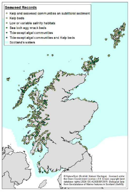
Kelp and other seaweeds are commonly found all around Scotland’s coastal waters. Over the past 50 years there have been various attempts to map and quantify the area of kelp beds in Scotland. Currently, the best estimate for kelp, based on a combination of on-site mapping and habitat suitability modelling, is 374,700 hectares.[23]
Figure 4 shows the current understanding of the distribution of kelp and other seaweeds in Scottish waters.
The main challenge for improving knowledge about the potential role of kelp and other seaweeds in climate change mitigation is tracing and understanding the export of biomass from growing kelp in coastal habitats to long-term burial. Accounting for the fate of kelp is critical for assessing its contribution to Scotland’s blue carbon stores.
Further work is also needed to more accurately calculate the carbon contained in the current stock of kelp and other seaweeds, particularly in deeper beds, across different locations, and within different seasons. Improved mapping of kelp beds would be beneficial and would be aided by the development of lower cost means to achieve this, for example through use of satellite imagery, drones, and other remote sensing techniques.
There is also emerging interest in the contribution of kelp and seaweed farming (also known as seaweed aquaculture) for climate change mitigation. This process capitalises on the highly productive growth of seaweeds, which lock in CO2 through photosynthesis, and uses the seaweed biomass in various product substitutions as a ‘greener’ alternative, e.g. for biofuels, fertilisers or food supplements or products. Life cycle assessments are needed for each of these approaches to understand all emissions and if a net CO2 reduction is achieved. A further application that has been proposed is to use seaweed aquaculture for carbon capture and storage processes, by growing, bailing, and sinking seaweed in the deep ocean. Under these conditions it is speculated that the cold temperatures and high pressure of the deep ocean would significantly slow the breakdown of seaweed material, to climate-relevant timescales (e.g. over 100 years). However, this approach contains several uncertainties, including the long-term fate of the organic carbon and the environmental impact it might have on deep sea ecosystems. Once addressed, legal and governance frameworks will need to be put in place in Scotland and internationally to licence for such activities.
Vulnerabilities and pressures
The main threats to kelp beds are ocean warming, increased frequency and intensity of storms, increased turbidity, nutrient input from industrial runoff, and removal of top predators leading to overgrazing by fish, sea urchins, and other marine life.[24] Unsustainable harvesting can also be a threat to kelp. Dredging and mechanical harvest of wild seaweeds is largely banned in Scottish waters and only collection by hand, following strict guidance, is allowed. Unsustainable harvesting is not currently considered to be a significant pressure in Scotland as harvesting is not widely practised.
Kelp and other seaweeds next steps
Most of the existing policies towards kelp beds are focused on nature conservation and biodiversity. Kelp and seaweed communities are recognised as PMFs, so must be given consideration in decision-making in line with National Marine Plan requirements, and as a protected feature within sites in the MPA network. These aspects of kelp and other seaweeds are well recognised and understood. Continuing to ensure that kelp and seaweed beds have the appropriate protections in place, including in upcoming fisheries management measures, is an important part of the path towards becoming nature positive and tackling the nature crisis.
The benefits of kelp and other seaweeds to climate change mitigation as a means to capture carbon and then store it naturally within its biomass is recognised as an emerging area of research. However, it is still not well enough understood to allow kelp to be integrated into the Scottish Government’s broader strategic approach to climate change mitigation and so further research is needed. The Scottish Government’s approach to this habitat at present is to ensure that decision-makers have access to the most up-to-date evidence in order to make informed decisions, while also closely monitoring new research to consider what impact it may have on policy. This is also an area where private actors, in particular industry, can contribute by developing the evidence base to explore potential for seaweed aquaculture as a means to store carbon.
The actions on kelp and other seaweeds will support objective 1 to ensure policies reflect the latest available evidence.
Actions
13. Improving access to evidence-based information. Work will be undertaken to ensure that public nature and restoration funders and other relevant decision-makers have access to robust and up to date evidence on the potential natural carbon storage contributions of kelp and other seaweeds, including from lifecycle assessments. This is to ensure that funds are appropriately targeted towards investments that can make a meaningful contribution to climate change mitigation. This work will be undertaken by the Scottish Government in 2025/26.
14. Review latest scientific evidence. Recognising that the evidence base on carbon storage in relation to both wild and farmed kelp and other seaweeds is rapidly developing, a systematic literature review to take stock of the latest evidence will be supported in order to inform future policy. This will be led by the Scottish Government in 2027/28.
Contact
Email: marineclimatechange@gov.scot