Highly Protected Marine Areas - policy framework and site selection guidelines: strategic environmental asessment
This initial strategic environmental report assesses the environmental impacts of the Highly Protected Marine Areas (HPMA) policy.
4 Environmental Baseline
4.1 Introduction
4.1.1 This section of the Environmental Report describes the character of the environment which may be affected by the designation of HMPAs following the implementation of the Policy Framework and Site Selection Guidelines. The focus of this baseline information is, therefore, on Biodiversity, Flora and Fauna; Soil (geodiversity); Water (the ecological status of WFD water and environmental status of the marine region under the UK Marine Strategy Regulations); and Climatic Factors (carbon cycling, storage and sequestration), reflecting the scope of the assessment as described in Section 3.3.
4.1.2 Scotland's location at the edge of the continental shelf means that it is subject to both subpolar and subtropical influences. The North Atlantic current brings warm water from the Gulf of Mexico to the west coast of Scotland. These warm waters mix with cooler polar waters from the Arctic in the north and east that are rich in nutrients. This unique geographic position means that the seas around Scotland contain a wide variety of habitats and species.
4.1.3 Scotland has over 18,000 km of coastline and its inshore and offshore areas are among the largest of any country in the European continent, representing 13% of all European seas.
4.2 Biodiversity, flora and fauna
4.2.1 Scotland's marine environment supports a diverse complex of different habitats, which in turn support a wide range of marine plants and animals. Estimates suggest there are around 6,500 species of animals and plants (excluding microbial flora and seabirds) in Scotland's seas[32].
Marine habitats
4.2.2 Benthic (seafloor) habitats are vital natural resources, as many marine species rely, directly or indirectly, on the seafloor to feed, hide, rest or reproduce. Generally benthic habitats are characterised by low mobility species[33]. Marine habitats within the Scottish marine environment can be characterised into three broad groups: intertidal habitats; subtidal (inshore and shelf sea); and deep sea habitats. These broad groups can be further broken down by substrate type.
4.2.3 The seabed is a critical component of marine ecosystems. Overall, mud, sand and coarse sediment are found in the North Sea, to the west of the Hebrides and in the north of Scotland. The seabed in the far west and north of Scotland is characterised by mud and fine clay, with coarser sediments in shallower water and on banks and seamounts[34].
4.2.4 The information presented in Figure 2 on predicted seabed habitats is provided by National Marine Plan Interactive (NMPi) and European Marine Observation and Data Network (EMODnet) Seabed Habitats. The layer is a predictive European Nature Information System (EUNIS) seabed habitat map for the UK continental shelf, which has been created using five pre-processed input datasets: substrate, biological zone, energy, salinity and biogeographic region (Figure 2 and key below).
Mobile species
4.2.5 Scotland's marine environment supports a wide range of mobile species with several populations considered to be either of international or national importance. Several mobile species within Scottish waters are already protected through designation or classification of areas within Scottish waters or around Scottish coastlines as discussed below under 'Protected habitats and species'. Mobile species in Scottish waters include the following groups:
- Seals (grey and harbour seals);
- Cetaceans (27[35] species have been recorded in Scottish waters over the last 25 years; of these, 11 are regularly sighted);
- Birds (both breeding seabirds and overwintering waterbirds);
- Fish, including sharks, rays and skates; and
- European otter.
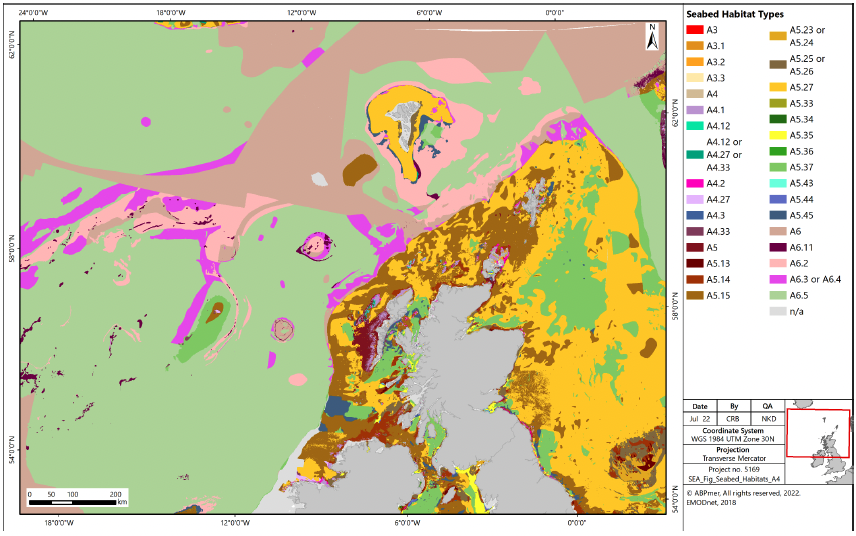
| Infralittoral rock and biogenic reef |
A3, A3.1, A3.2, A3.3 |
| Circalittoral rock and biogenic reef |
A4, A4.1, A4.2, A4.3 |
| Offshore circalittoral rock and biogenic reef |
A4.12 or A4.27 or A4.33, A4.27, A3.33 |
| Infralittoral coarse sediment |
A5.13 |
| Circalittoral coarse sediment |
A5.14 |
| Offshore circalittoral coarse sediment |
A5.15 |
| Infralittoral sand |
A5.23 or A5.24 |
| Circalittoral sand |
A5.25 or A5.26 |
| Offshore circalittoral sand |
A5.27 |
| Infralittoral mud |
A5.33, A5.33 or A5.34, A5.34 |
| Circalittoral mud |
A5.35, A5.35 or A5.36, A5.36 |
| Offshore circalittoral mud |
A5.37 |
| Infralittoral mixed sediment |
A5.43 |
| Circalittoral mixed sediment |
A5.44 |
| Offshore circalittoral mixed sediment |
A5.45 |
| Upper bathyl sediment |
A6, A6.2, A6.3, A6.4, A6.4 or A6.5 |
| Upper bathyl rock and biogenic reef |
A6.11 |
| Not applicable (land) |
Na |
Marine mammals (cetaceans, seals and otters)
4.2.6 Marine mammals are widely distributed around the Scottish coastline. Species distributions are a function of prey availability and habitat distribution. Eleven species of cetacean are regularly sighted around Scottish seas. These comprise species with important resident populations, such as bottlenose dolphin, alongside more migratory species passing through Scottish seas, such as sperm whale. Key marine mammal species in Scottish seas include:
- Grey seal;
- Harbour seal;
- Harbour porpoise;
- Bottlenose dolphin;
- White-beaked dolphin;
- Fin whale;
- Minke whale;
- Short-beaked common dolphin;
- Atlantic white-sided dolphin;
- Risso's dolphin;
- Long-finned pilot whale;
- Killer whale;
- Sperm whale; and
- European otter.
4.2.7 All of the above species are considered to be PMFs, as discussed below under 'Priority Marine Features'.
4.2.8 Information regarding cetaceans in the deep sea environment in offshore Scottish waters is limited, although some species present in Scottish waters are known to dive to significant depths and could, therefore, have some interaction with the offshore environment. For example, it is known that most migrating individuals of humpback whales remain in deep water off the continental shelf[36], with increasing records year on year[37]. However, the current understanding of the interaction of cetaceans in offshore waters is limited.
Fish
4.2.9 Scotland's inshore waters support approximately 250 different species of fish, with additional species occurring in deeper waters within the Scottish marine area. Some species are commercially important to the Scottish fishing industry, and others, such as sandeel, are key prey species for seabirds, marine mammals and larger fish species, including some shark species. There are several migratory anadromous fish species within Scottish waters which use Scottish rivers for spawning, including Atlantic salmon, shad, sea trout and lamprey. Thirty-one species of fish are identified as PMFs within Scottish waters[38].
4.2.10 Of the 250 species of fish identified in Scottish waters, 40 are cartilaginous fish (Chondrichthyes), incorporating species of shark, rays and skates. Within Scottish seas, there are nationally important populations of basking sharks. Significant numbers of sightings are concentrated around the Inner Hebridean islands of Coll, Tiree, Canna and Hyskeir and have been highlighted as potential breeding grounds.
4.2.11 There are also a number of fish species present in the offshore waters of Scotland. JNCC has reviewed literature available on eleven species of fish present in the deep waters to the west and north of Scotland[39]: the gulper shark, Atlantic halibut, orange roughy, porbeagle shark, spurdog, leafscale gulper shark, Portuguese dogfish, the roundnose grenadier, blue ling, anglerfish and Greenland halibut. Of the species, the gulper shark, leafscale gulper shark, Portuguese dogfish and orange roughy are included in the OSPAR list of threatened and declining species and habitats[40].
4.2.12 Fish which are known to use the offshore area and are also designated as PMFs comprise anglerfish, Atlantic halibut, Atlantic herring, black scabbardfish, blue ling, blue whiting, cod, European hake, Greenland halibut, Horse mackerel, ling, Norway pout, orange roughy, round-nose grenadier, saithe, sandeel and whiting[41].
4.2.13 Sharks and rays which are known to use the offshore marine area include the basking shark, sandy ray, thresher shark and blackmouth shark[42]. The basking shark is a PMF which migrates over large distances in both Scottish offshore and coastal waters at depths from the surface to over 750m. They are particularly associated with tidal fronts on the continental shelf and shelf edge where they feed on plankton. The sandy ray is a PMF, which occurs at depths from 70 to 275m, and is typically found on sandy or muddy sea beds to the north-west of Scotland. The thresher shark is typically found 40 to 75 miles offshore and is considered rare in Scottish waters. The blackmouth shark is found throughout Scottish waters but is more abundant in deeper offshore waters.
Birds
4.2.14 Scotland, and its coastline, is important for marine and coastal birds, including seabirds, seaducks, divers, grebes, waders and waterfowl. Scotland provides an essential feeding station for migrating birds; a safe winter haven for ducks, geese and shorebirds; and provides nesting sites for seabird species. It holds internationally significant numbers of 24 species of breeding seabirds, with additional migratory species of waterbird overwintering on Scotland's coasts[43].
4.2.15 Seabirds respond to a range of factors, such as changes in food availability, weather, predation and pollution. Breeding abundance and productivity is assessed for a number of the species that breed in Scotland based on a representative sample of colonies around Scotland, which are monitored as part of the UK Seabird Monitoring Programme[44].
4.2.16 Scotland hosts large numbers of wintering seaduck, divers and grebes. Seaducks undertake surface diving to capture molluscs such as mussels and clams as well as crustacea. Divers and grebes are predominantly piscivores or in some cases insectivores, preying on a variety of small fish such as clupeids, sandeel and small gadoids by undertaking pursuit diving.
4.2.17 The highly pathogenic avian influenza (HPAI) virus H5N1 is circulating widely within wild bird populations in Scotland[45]. The situation is rapidly evolving and there is concern about the impact of HPAI on vulnerable bird species, particularly in waterfowl, seabirds and raptors. The outbreak has resulted in significant declines in the Svalbard population of barnacle geese, northern gannet and great skua. Twenty-eight species of wild birds have tested positive during the current outbreak, including gulls, terns, auks and Manx shearwater.
Protected habitats and species
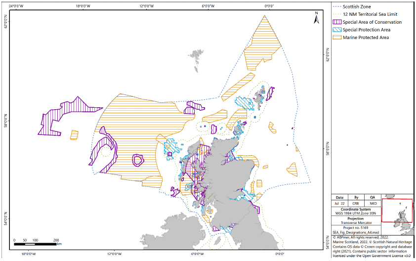
4.2.18 The importance of Scotland's marine ecosystems is reflected in the range of designations which protect them at the international and national levels. All designations are included and incorporated into Scotland's MPA network, covering approximately 37% of Scottish seas[46]. The current designations in Scottish inshore and offshore waters are:
- SACs: These include both inshore and offshore SAC and cover eleven different marine habitat types which occur in Scotland (sandbanks which are slightly covered by seawater all the time; estuaries; mudflats and sandflats not covered by seawater at low tide; coastal lagoons; large shallow inlets and bays; reefs; submarine structures made by leaking gases; and submerged or partially submerged sea caves). Seven marine species that occur in Scotland are also protected (bottlenose dolphin, harbour porpoise, grey seal, harbour seal, sea lamprey, Atlantic salmon and otter);
- SPAs: These protect and are of international importance for a number of bird species (e.g. seabirds, waders, ducks and geese);
- NCMPAs: These protect habitats and species such as maerl beds, coral gardens and common skate;
- SSSIs: These are nationally designated sites which protect species such as seabirds and seals, and habitats such as sea caves and rocky shores; and
- Ramsar sites: There are designated for their internationally important wetlands. Each Ramsar site is also be designated as either a SPA or SAC, depending on the features present.
4.2.19 Existing and proposed SACs, NCMPAs, and SPAs sites are shown in Figure 3.
4.2.20 There are 58 SACs with marine components in Scotland, 47 of which are in inshore waters, nine are completely in offshore waters, and a further two sites which have parts in both inshore and offshore waters.
4.2.21 Scotland currently has 56 marine SPAs with marine or coastal components, 53 of which are wholly within Scottish inshore waters and three which overlap both inshore and offshore waters.
4.2.22 The Scottish Government has designated 36 NCMPAs, 13 of which are offshore[47]. There is also a Demonstration and Research MPA around Fair Isle[48].
4.2.23 There are 65 SSSIs[49] with marine components in Scotland. These include land and the foreshore generally only down to mean low water spring tide level.
4.2.24 There are also 51 Ramsar sites in Scotland designated as internationally important wetlands, covering a total area of about 326,719 hectares[50], of which 16 form part of the MPA network[51].
4.2.25 The Habitats Regulations[52] as amended by the Conservation of Habitats and Species (Amendment) (EU Exit) Regulations 2019[53],[54] also affords protection to certain species of plants and animals (European Protected Species). In the marine environment these include cetaceans and otters.
Priority marine features
4.2.26 In July 2014, Scottish Ministers adopted a list of 81 PMFs. PMFs are species and habitats which have been identified as being of conservation importance to Scotland[55]. Most are a subset of species and habitats identified on national, UK or international lists. The National Marine Plan includes a policy (GEN 9 Natural Heritage) for safeguarding PMFs whereby 'Development and use of the marine environment must not result in significant impact on the national status of PMFs'[56].
4.2.27 The list of 81 PMFs comprises 26 broad habitats (e.g. burrowed mud), seven low or limited mobility species (e.g. ocean quahog) and 48 mobile species, including fish (e.g. blue ling) and marine mammals (e.g. minke whale).
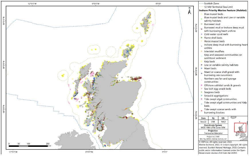
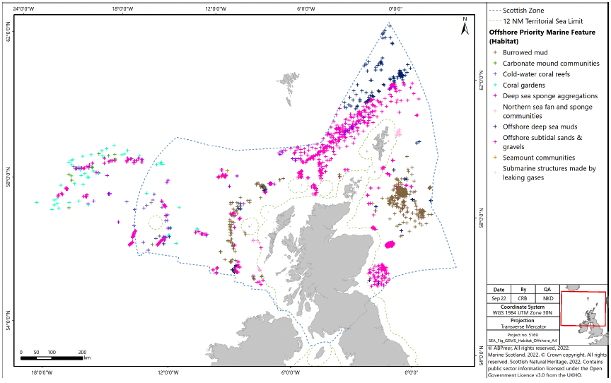
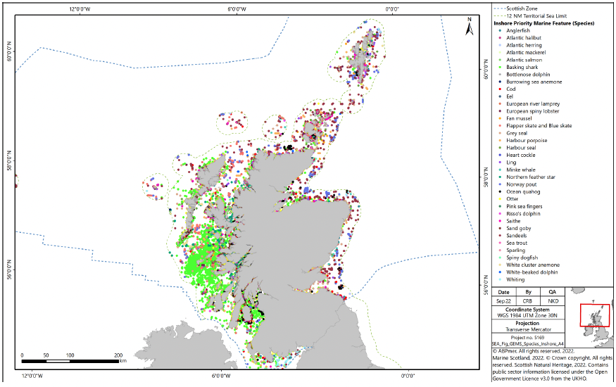
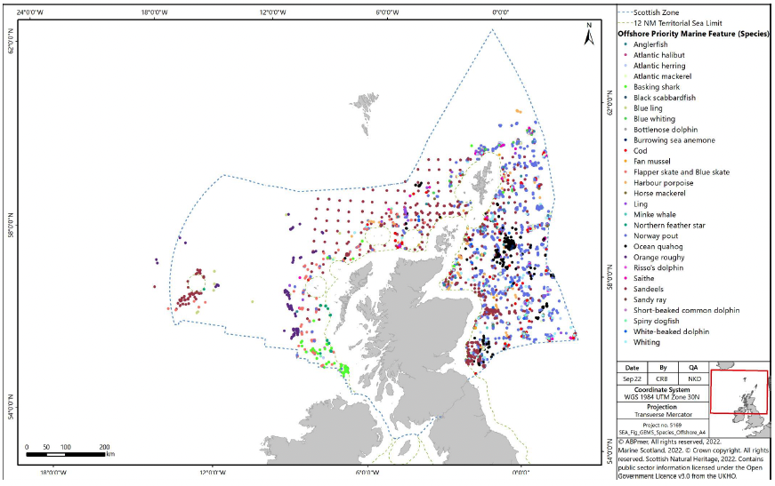
4.2.28 Available PMF data relevant to the inshore and offshore waters of Scotland are presented in Figure 4 to Figure 7. The information has been collated in a computer database called GeMS (Geodatabase for Marine Habitats and Species adjacent to Scotland)[57].
4.2.29 Kelp beds, burrowed mud, sand banks, maerl beds, seagrass, horse mussel beds, flame shell beds and Northern sea fan and sponge communities are PMF habitats identified within the Scottish inshore area (Figure 4). PMF species identified within the Scottish inshore area include basking shark, sand goby, whiting, harbour seal, grey seal, saithe, whiting, ocean quahog, northern feather star, flapper and blue skate and anglerfish (Figure 6).
4.2.30 Regarding PMF habitats within the Scottish offshore area, offshore subtidal sands and gravels can be identified in the north and south east. Larger patches of burrowed mud can be found to the east, and smaller patches are identified to the west of the Scottish offshore area. Offshore deep sea muds are identified in the north, with smaller patches to the west (Figure 5). Further offshore in western waters, habitats include offshore subtidal sands and gravels, coral gardens, carbonate mound communities and deep sea sponge aggregations. PMF species that inhabit the Scottish offshore area include Norway pout which is wide ranging in the west, as well as sandeel, whiting, Atlantic herring, harbour porpoise and horse mackerel (Figure 7).
1.1.1 4.2.31 There are a range of management measures already in place to protect the most vulnerable deep-sea marine ecosystems, not least through gear restrictions in deep waters, and a range of inshore and offshore MPAs have been designated to protect habitats, species and large-scale features. Fisheries management measures have been introduced in many of the inshore MPAs[58], which also serve to protect PMFs.
4.2.32 Although many PMFs are protected within the MPA network, there is a need to ensure adequate protection of PMFs outwith the MPA network. Management measures involving no use of bottom-contacting mobile fishing gears have, therefore, been proposed for 11 of the most vulnerable PMFs and these are currently being assessed as part of a separate SEA (see Section 3.6).
Trends and pressures
4.2.33 Within the marine environment there are a number of pressures on biodiversity, flora and fauna. Scotland's Marine Atlas presented an assessment of the condition of Scotland's seas and a summary of significant pressures and the impacts of human activity[59]. It was based on scientific evidence from available data and analysis, supported by expert judgement and taking account of key data gaps[60].
4.2.34 The Marine Atlas reviewed the condition of the five major seabed habitat types in Scottish waters. There were few or no concerns about subtidal rock. Intertidal rock and sediments show evidence of deterioration, with one concern being the introduction of non-native invasive species such as wireweed (Sargassum muticum), a brown alga. The most significant level of concern related to the condition of shallow and shelf subtidal sediments, mainly as a result of fishing practices such as demersal fishing (trawling) and scallop dredging. There were also some concerns about the effects of trawling on deep sea habitat, although such activity has since been banned at depths greater than 800 m. Vulnerable marine ecosystems are also closed to bottom gear fishing at depths greater than 400 m.
4.2.35 The Marine Atlas also assessed the condition of a number of species groups. Those that are relevant to the assessment are summarised below together with other available data sources.
Cetaceans
4.2.36 There is limited information in the Marine Atlas with regard to the condition of cetacean populations within Scottish waters. However, where the condition can be assessed, the populations are considered to be favourable (namely harbour porpoise, bottlenose dolphin, minke whale, white-beaked dolphin and fin whale).
Seals
4.2.37 Due to Covid restrictions through summer 2020, no recent large-scale surveys of Scottish harbour seal populations have been undertaken[61]. Populations of harbour seals along the east coast of Scotland and in the Northern Isles have generally declined since the early 2000s. Though declining at different intensities, all areas had a current population size at least 40% below the pre-2002 level. Populations in North Coast & Orkney Seal Management Unit (SMU) and in the Tay and Eden SAC are continuing to decline. Although declines are not evident in Shetland or the Moray Firth, there is no indication of recovery. Populations in western Scotland are either stable or increasing. Counts in the central and northern sections of the large West Scotland SMU and the Southwest Scotland SMU have been increasing since the 1990s and in all other areas they have remained stable.
4.2.38 Grey seal populations are considered to have a stable population, albeit fluctuating within Scottish waters.
Fish
4.2.39 Populations of sharks/rays are declining and, as these animals are slow growing, late to reach maturity, and typically have low fecundity, populations take some time to recover from pressures such as overfishing.
4.2.40 The Marine Atlas also noted that populations of many commercial fish species are declining and that this is of particular concern in the Solway Firth, North Channel, Clyde, Minches and Malin Sea, North Scotland coast and West Shetland. The decline in the availability of sandeels associated with changes in oceanographic conditions is considered to have had a major influence on changes in seabird numbers on the east coast and in the Northern Isles.
Birds
4.2.41 Prior to the outbreak of bird flu, the seabird populations of Scotland were increasing in some areas (Solway Firth and the Clyde, for example) and decreasing in others. In East and West Shetland and along the North Scotland coast, this decrease was considered to be related to a shortage of prey species (e.g. sandeels) resulting from changes in oceanographic conditions.
4.2.42 Like seabirds, waterbirds (wildfowl and waders) were also both increasing and decreasing, depending on the species. The reasons for declines were considered in part to have been a result of the redistribution of wintering birds across northwest Europe due to climate change effects.
4.2.43 However, as noted earlier, the influenza virus H5N1 is circulating fast amongst wild bird populations in Scotland and is anticipated to result in significant declines in a number of species[62].
Current and future pressures
4.2.44 Box 3 sets out some of the key current and future pressures on marine biodiversity, flora and fauna. The Feature Activity Sensitivity Tool (FEAST) provides more comprehensive information on the relevant pressures associated with a range of marine activities and the sensitivity of protected features to these activities and pressures[63].
Box 3 - Pressures on marine biodiversity, flora and fauna
Commercial fishing:
- Removal of target fish species may affect the sustainability of fish stocks, particularly where catches are above the level consistent with achieving maximum sustainable yield;
- Discards of fish are a waste of the resource, and also encourage scavenger species;
- Bycatch of both non-target fish and other species,
- Abrasion of the seabed and its benthic habitat by mobile fishing gear, with the consequent loss of marine plants and animals; and
- Removal of target species may also decrease the availability of prey species, leading to declines in populations of other species (e.g. birds).
Non-native invasive species:
- May outcompete native species, thereby displacing them from the marine environment.
Marine litter:
- Can result in the injury and/or death of marine animals through entanglement, ingestion of litter (including plastic microparticles in particular), or both.
Navigation dredging:
- Can result in loss of and/or damage to the seabed and the habitat that it supports
- May give rise to suspended sediments, resulting in decreased water quality, reduced visibility for foraging fauna and/or smothering of the seabed if these sediments settle out in a different area; and
- May disturb marine animals, including through increased noise levels.
Marine transport:
- Risk of collision of vessels with marine animals, resulting in their injury and/or death;
- May result in increased coastal erosion through the action of vessel wakes; and
- Vessel noise can impact marine animal behaviour and result in disturbance and / or displacement, including displacement of bird species from the water.
Aquaculture:
- May give rise to elevated nutrient levels in and on the seabed from fish faeces and excess animal feed, which can result in changes to community composition and/or smothering of the seabed;
- Elevated concentrations of contaminants used in sea lice treatment, fish health and anti-fouling;
- Nets associated with aquaculture can result in the injury and / or death of marine animals through entanglement;
- Can damage the seabed and its habitat through anchoring of infrastructure;
- May affect wild salmon through transmission of sea lice; and
- May disturb marine animals, including through increased noise levels associated with Acoustic Deterrent Device (ADD) operations at finfish aquaculture sites.
Marine wildlife watching:
- May result in increased disturbance and displacement to populations of marine animals such as whales, dolphins and bird species; and
- May give rise to collision risk of mobile species with vessels (e.g. birds, mammals etc.).
Recreation:
- May result in loss of and/or damage to the seabed and its habitat through anchoring
- May give rise to increased levels of marine litter;
- May disturb marine animals if the Scottish Marine Wildlife Watching Code is not adhered to through human and/or vessel presence; and
- May give rise to collision risk of mobile species with vessels (e.g. birds, mammals etc.).
Offshore renewables:
- May result in loss of and/or damage to the seabed and its habitat, through anchoring of infrastructure;
- May give rise to collision risk (e.g. with birds, mammals, etc.);
- Could result in changes to sediment transport through changes in energy levels in the water; and
- May disturb marine animals, particularly through increased noise levels associated with construction activities (e.g. percussive piling) and survey activities.
Climate change (increasing sea temperatures, acidification, changes to rainfall patterns, increased extreme weather events etc.):
- May result in populations of marine animals and plants moving further north;
- May result in increased levels of seabird mortality (including large scale events such as seabird wrecks), due to increased levels of extreme weather events;
- May give rise to population decline; and
- May result in new competitors arriving in Scottish waters, including non-native invasive species.
Survey Activities
- May disturb marine animals, through increased noise levels in the marine environment associated with the use of acoustic survey equipment; and
- May give rise to collision risk of mobile species with vessels (e.g. birds, mammals etc.).
Coastal Development
- May result in loss of and/or damage to the seabed and its habitat, through construction of infrastructure;
- Could result in changes to sediment transport through changes in coastal processes; and
- May disturb marine animals, through increased noise levels in the marine environment associated with construction activities.
4.3 Soil (Geodiversity)
Seafloor geodiversity
4.3.1 Geodiversity is defined as the natural range (diversity) of geological features (rocks, minerals, fossils and structures), geomorphological features (landforms and processes) and soil features that make up the landscape both on land and below water. The condition of underlying geodiversity features such as sand banks and seabed influence the quality of habitats which in turn affects the viability and health of both flora and fauna populations.
4.3.2 There are six protected features of Scottish geodiversity:
- Quaternary of Scotland;
- Submarine Mass Movement;
- Marine Geomorphology of the Scottish Deep Ocean Seabed;
- Seabed Fluid and Gas Seep;
- Cenozoic Structures of the Atlantic Margin; and
- Marine Geomorphology of the Scottish Shelf Seabed.
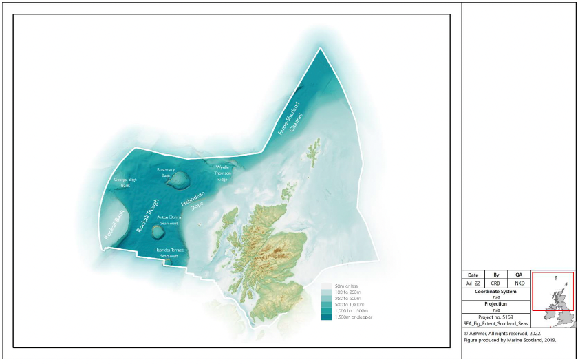
4.3.3 Each feature has a variety of components, such as continental slope channels, iceberg ploughmark fields, moraines, slide deposits, sand wave fields, pockmarks, seamounts, sand banks and mega-scale glacial lineation. Major physiographical features of the Scottish marine environment are shown in Figure 8.
4.3.4 Scottish waters are geomorphologically distinct between the east and west coasts. The east coast presents mostly uniform depths and shallow inclines interspersed with localised trenches, while the seabed off Scotland's west coast shelves steeply away from the coast, and deep waters occur relatively close to the land.
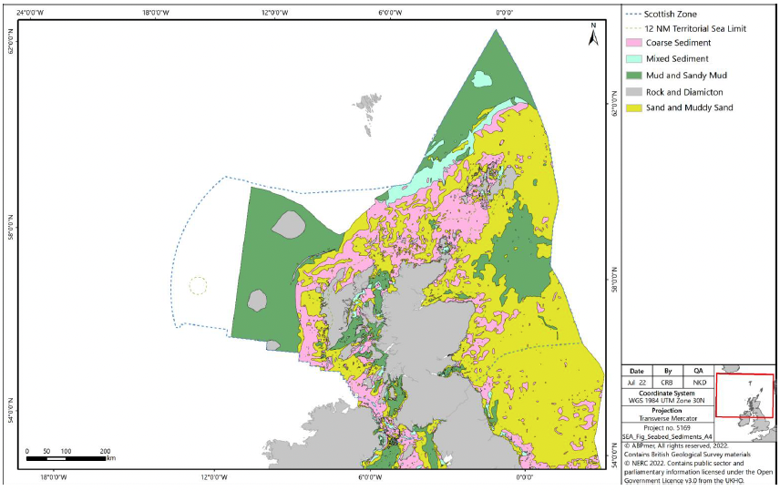
4.3.5 Data from the British Geological Society (BGS) indicates that Scottish waters have a wide range of seabed habitats, ranging from scoured rock or coarse sediment to muddy gravel or fine sand in some areas (Figure 9). A description of the key habitat types in Scottish waters is provided in the section on 'Marine Habitats' above.
4.3.6 In general, marine sediments are sandy or gravelly and originate from deposits during the Quaternary glaciation. Muddy sediments occur principally nearshore or, further offshore, in depressions on the sea floor, where currents may be relatively weak. They also occur beyond the shelf break (200 m water depth) to the west of Scotland. The concentration of calcareous material varies greatly in seabed sediments, reflecting the amount of shell material in different areas, and can locally be very high [64].
4.3.7 Throughout the west of Scotland and north-east of the Wyville-Thomson Ridge, topographic features influence the prevailing currents and consequently, the sediment types present[65],[66],[67],[68],[69]. In general, deep sea, subsurface currents are weaker when compared with surface flows but are intensified around topographic features such as seamounts, the continental slope and the Rockall Bank[70],[71]. In deeper areas, away from large topographic features and with low or negligible currents, finer, muddy sediments are present[72]. The highly varied topography in the region of the Faroe-Shetland Channel results in complex current patterns, which in turn influence sediment distribution patterns. Within the Faroe-Shetland Channel, stronger currents are present as the channel narrows toward the Wyville-Thomson Ridge; this results in coarser sediments being located at greater depths compared with the deep sea to the west of Scotland[73]. Low sediment deposition rates in the Faroe-Shetland Channel also play a role in determining which sediments are present[74]. Overall, there is a trend of increasing mud content from the southwest to the northeast within the Faroe-Shetland Channel. There are higher percentages of sands and gravels around such features as the Rockall Bank, the continental slope and around the Wyville Thomson Ridge.
4.3.8 Several geological sedimentary features exist in Scottish offshore waters. These features may take the form of slide deposits, iceberg plough marks, sediment drifts, sediment wave fields, sand contourites and barchan sand wave fields[75], mud diapirs[76] / mounds and sediment plains. Within the Faroe-Shetland Channel, including the approach to the Wyville-Thomson Ridge, Bett (2012)[77] illustrates the distribution of the known sedimentary physical features. Below 800 m these include contourite deposits, barchan sand dunes, gravel / cobble deposits, landslide debris (mud blocks) and mud diapirs and mud mounds.
4.3.9 Sediments along the Hebridean slope to the west of Scotland show a general decrease in grain size with increasing depth and are described as being thickest within the eastern Rockall Trough and along the Hebridean slope and thinnest in the western Rockall Trough and on the Rockall Plateau[78]. A survey to locate rocky reef features on the Rockall Bank also recorded this gradation in sediment type, identifying mud habitats at the base of the bank in ~1,100 – 1,600 m depth[79]. Along the continental slope, sediments change from sands at 700 m to silty mud and mud between 700 – 1,000 m depth with gravel patches being rare and cobbles and boulders even rarer[80]. Sediments extending into the Rockall Trough are described as being mainly mud with some areas of coarse sand and gravel.
Coastal geodiversity
4.3.10 Much of Scotland's landscape and coastline was initially formed through the processes of glacial erosion and deposition. Today the coast continues to change as a result of coastal processes such as wave action, sediment movement, erosion and accretion. The 2004 European Initiative for Sustainable Coastal Erosion Management (Eurosion) survey of Scotland's coastline reported that it comprises predominantly hard coasts of rocks and cliffs (70%); soft coasts that are potentially susceptible to erosion impacts, consisting of unconsolidated gravels, sand and silts (29%); and artificial coasts such as harbours and sea walls (less than 1%).
Trends and Pressures
4.3.11 Coasts are dynamic environments, continually changing in response to variations in weather, land use and the supply of sediment. This capacity to change encourages landholders to try to design schemes to restrict and control this natural dynamism. Restricting coasts affects water and sediment flows, which can destroy wildlife habitat and reduce landscape value and diversity. Intervention at one point of a coast can have a negative knock-on effect at another point in the dynamic landscape.
4.3.12 Pressures on geodiversity features in Scottish seas arise from multiple activities, including fishing, infrastructure development, seafloor exploration activities, oil and gas extraction and renewable energy development[81]
4.4 Water
Ecological status of WFD water bodies
4.4.1 There are various mechanisms in place for monitoring and managing the quality of Scottish inshore waters. Each takes a different focus and approach:
- The WFD establishes a framework for the protection of inland surface waters (rivers and lakes), transitional waters (estuaries), coastal waters and groundwater; with the aim of ensuring that all aquatic ecosystems meet 'good status';
- River Basin Management Plans (RBMPs) have been prepared for the Scotland and Solway-Tweed River Basin Districts to address the requirements of the WFD in relation to the management of Scotland's river systems. Both plans also provide an overview of the state of the water environment for their districts. The plans have been updated since the first cycle (2009 – 2015) and are currently in the second cycle (2015 – 2027); and
- Scotland's coastal waters are monitored by Scottish Environment Protection Agency (SEPA) to measure performance and compliance with targets for coastal water quality status under the WFD.
4.4.2 Coastal and transitional water bodies are classified in terms of their ecological and chemical quality. For those water bodies not designated as heavily modified or artificial, this ecological quality is described in terms of 'ecological status', which defines how much ecological quality deviates from natural conditions. The quality elements used to assess ecological status are:
- Biological quality elements (water, plants and animals);
- Chemical and physicochemical elements (e.g. oxygen and nutrient levels); and
- Hydromorphological quality elements (water flows and levels; the condition of beds, banks and shores; and the continuity of rivers for fish migration).
4.4.3 For good status, the chemical, physicochemical and hydromorphological quality of the water body must achieve the standards and conditions necessary for the biological quality elements to be in good condition. The ecological status of a water body is determined by the lowest-classed quality element.
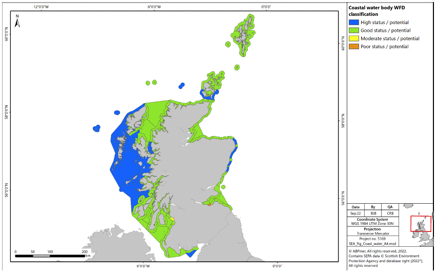
4.4.4 Scotland's coastal and transitional water bodies are mostly classed as being of "high" or "good" ecological status under the WFD[82]. As part of the latest assessment undertaken in 2020, over 99% of coastal water bodies were in good or better condition (143 high, 312 good, 1 moderate and 1 poor) and 88% of transitional water bodies were in good or better condition (11 high, 31 good, 5 moderate and 1 poor). The poor quality coastal water body occurs at 'Leith Docks to Port Seton' respectively (Figure 10). The poor quality transitional water body occur at 'Solway Estuary'.
4.4.5 In terms of protected areas under the WFD, there are 85 designated bathing waters and 80 designated shellfish waters in Scotland. The latest available classification data from 2021 assessed 67 (79%) bathing waters as excellent or good status, 17 (20%) as sufficient status, and 1 (1%) as poor status[83]. The latest available classification from 2014, assessed 29 shellfish waters as at target objective, with the remaining 51 assessed as not at target objective[84].
Environmental status of marine region
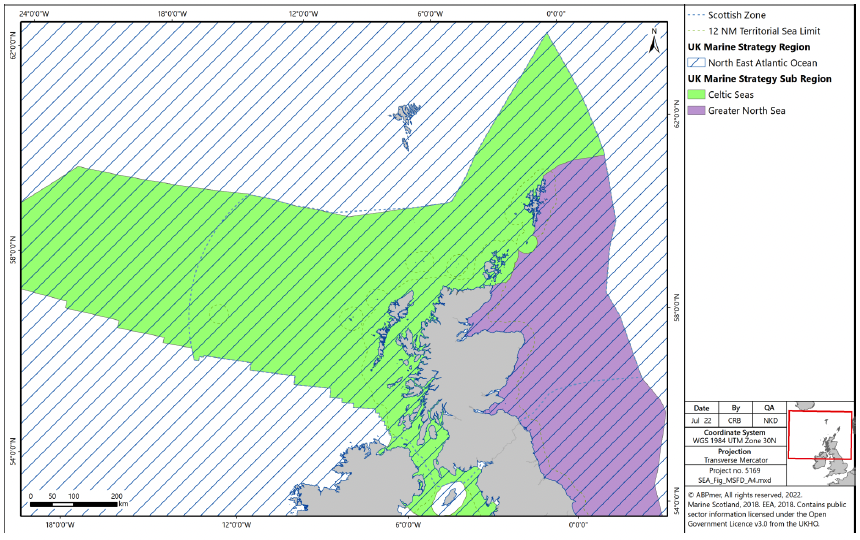
4.4.6 The mechanism in place for monitoring and managing the quality of Scottish offshore waters is the UK Marine Strategy Regulations. The North-East Atlantic Ocean marine region and the Celtic Seas and Greater North Sea sub regions that overlap Scottish waters are shown on Figure 11.
4.4.7 Achieving GES under the UK Marine Strategy involves satisfying several elements (known as descriptors (D)), namely D1 biological biodiversity (cetaceans, seals, birds, fish, pelagic habitats and benthic habitats); D2 non-indigenous species; D3 commercially-exploited fish and shellfish; D4 food webs (cetaceans, seals, birds, fish and pelagic habitats); D5 eutrophication; D6 sea-floor integrity (pelagic habitats and benthic habitats); D7 hydrographical conditions; D8 contaminants; D9 contaminants in fish and other seafood for human consumption; D10 litter and D11 introduction of energy, including underwater noise[85].
Trends and Pressures
4.4.8 Since the first RBMPs in Scotland were published in 2009, the condition of water bodies has generally improved. However, a wide range of pressures are continuing to impact on the condition of specific water bodies and protected areas. The most widespread pressures on the water environment in the Scotland River Basin District (RBD) are man-made barriers to fish migration, modifications to physical condition, rural diffuse pollution, waste water discharges and hydroelectricity generation[86]. The main reasons for water bodies in the Solway Tweed RBD not being in good condition are pollution from agriculture and rural land management, changes to water levels and flows, modifications to physical condition, including man-made barriers to fish migration, and invasive non-native species[87].
4.4.9 The updated UK Marine Strategy Part 1 published in 2019 presents the progress that has been made towards achieving GES in the North-East Atlantic Ocean marine region since the first assessment was undertaken in 2012[88]. In summary, GES has been achieved for eutrophication, changes in hydrographical conditions, contaminants, and contaminants in seafood[89]. GES has been partially achieved for cetaceans, seals, pelagic habitats, food webs and input of anthropogenic sound. GES has not been achieved for birds, fish, benthic habitats, non-indigenous species, commercial fish and shellfish, and litter.
4.4.10 Since 2012, environmental status has declined for birds, and has remained stable for cetaceans, pelagic habitats, benthic habitats, non-indigenous species, eutrophication, changes in hydrological conditions, litter and input of anthropogenic sound[90]. Environmental status has improved since 2012 for seals, fish, commercial fish and shellfish, food webs, contaminants, and contaminants in seafood.
4.4.11 Potential pressures against the UK Marine Strategy include increases in fishing activity, increases in oil and gas activity (and associated chemical discharges), increases in seabed extractive activities (i.e. seabed mining) and increases in offshore renewable development.
Climatic factors (including carbon cycling, storage and sequestration)
4.4.12 The term 'carbon cycle' refers to the circulation of carbon in the environment. In the context of this report, it focusses on the exchange of carbon between the ocean and the atmosphere. The proportion of carbon incorporated into biomass is said to be 'stored'; thus, marine ecosystems such as kelp forests, maerl beds and marine sediments are able to store carbon. The addition of solid carbon to these long-term stocks is referred to as sequestration, and the conversion of atmospheric carbon dioxide to solid carbon in living material is referred to as fixation. The stored carbon can be released, however, through physical disturbance, bacterial decomposition of organic matter or respiratory processes within the food chain.
4.4.13 A significant proportion of carbon sequestration occurs through fixation during oceanic photosynthesis and the subsequent long-term storage of the produced organic material. In addition to carbon being sequestered within the oceanic sediments, another important portion is stored within living marine organisms. These organisms include taxa that possess calcium carbonate skeletons and shells such as coral and molluscs, with other carbon captured and stored in plant dominated habitats such as seagrass beds, kelp forests and maerl.
4.4.14 Within the marine environment, habitats and processes capable of carbon fixation and sequestration are defined as 'blue carbon sinks'. Multiple habitats across Scottish seas and coastal areas can be termed blue carbon sinks due to their fixation and sequestration ability. Their effectiveness as carbon sinks is highly dependent upon their long-term capacity to store carbon. Habitats present in Scottish waters that are classed as blue carbon sinks are[91]:
- ▪ Kelp forests;
- ▪ Intertidal and sub-canopy macroalgae;
- ▪ Saltmarshes;
- ▪ Seagrass beds;
- ▪ Maerl beds;
- ▪ Horse mussel beds (Modiolus modiolus);
- ▪ Flame shell beds (Limaria hians);
- ▪ Lophelia pertusa reef;
- ▪ Tubeworm (Serpula vermicularis) reef;
- ▪ Blue mussel beds (Mytilus edulis);
- ▪ Brittlestar beds;
- ▪ Sediments; and
- ▪ Phytoplankton.
4.4.15 The largest contribution to carbon fixation and sequestration in Scottish waters comes from phytoplankton, via photosynthesis and subsequent deposition of the produced organic matter in seabed sediments. This may occur either directly through the export of phytoplankton or indirectly through the consumption of phytoplankton by other organisms and subsequent export of this organic matter through the food chain[92].
4.4.16 Carbon stored in shallow shelf sediment tends to be ephemeral and constantly exchanged due to the dynamic nature of such habitats. Therefore, the potential for shallow shelf sediments to provide long term carbon storage is a function of sedimentation rates and the degree of recycling of organic carbon. The rate of recycling of organic carbon is driven by the level of oxygen available for bacterial and chemical breakdown of organic matter[93], which is primarily influenced by disturbance of seabed sediments and the oxygen content of the seawater above the seabed.
4.4.17 Deeper sediments are less mobile and dynamic and, therefore, are able to store carbon to a greater extent, but the rate of uptake into the sediment is slower as sedimentation rates in deeper waters are reduced.
4.4.18 Kelp forests, ubiquitous along the rocky shore common around Scotland, are identified as a significant carbon store. However, the fate of carbon within kelp (i.e. whether it is eventually sequestered permanently) is not quantified, and the majority of stored carbon in kelp is understood to be recycled rather than sequestered[94]. In addition, brittlestar beds are identified as one of the largest components of inorganic carbon fixation (18,000 tonnes per year)[95].
4.4.19 Several of the other habitats listed, including maerl beds, are more efficient at carbon fixation and sequester a larger proportion of carbon relative to their physical extent, but as their total extent across Scotland is low, they do not contribute as much to the Scottish estimate.
Trends and pressures
4.4.20 Climate change has the potential to affect the carbon sequestration capacity of marine habitats. Kelps and seagrasses are likely to be vulnerable to increases in the frequency of severe storms which have the potential to cause physical damage and reduce habitat extents and hence reduce carbon storage potential. For seagrasses, reductions in canopy density resulting from physical damage may also decrease this habitat's ability to trap sediment and deflect wave energy away from the bed. Carbon-storing sediments are, therefore, likely to be more vulnerable to wave scour and subsequent resuspension during severe storms. Resuspension events increase the opportunity for organisms to recycle any biologically available carbon from the sediment, reducing sequestration in the sediment once it re-settles on the seabed.
4.4.21 Such storm events are also likely to increase the turbidity of the water through increased sediment resuspension, which could potentially reduce available light for photosynthesis, reducing growth rates and, therefore, reducing the overall carbon sequestration capacity of marine habitats. However, in offshore areas, storm events will have no influence on turbidity due to the water depths.
4.4.22 Several marine activities (e.g. fishing, deep sea mining, oil and gas activities and renewable energy development) physically disturb the seafloor. As previously stated, any physical damage caused to a habitat has the potential to disturb, remove or release any carbon held within that store. However, it may also increase other nutrient levels, which could in turn increase the levels of primary production. The level of impact will depend on the specific area affected. For example, the trawling of ephemeral, gravelly areas will release negligible amounts of carbon, but a trawl across deep sea carbon rich sediments may have greater impacts. In general, direct physical disturbance from marine activities has the potential to affect how Scotland's marine environments regulate atmospheric carbon levels.
4.4.23 Shelf seas around the UK are predicted to be 1°C to 4°C warmer by the end of the 21st century[96]. Warmer sea temperatures could result in a shift in distribution of certain habitats and species. Climate change may also favour some species, leading to a potential increase in the diversity of seabed marine life[97]. Biodiversity and benthic biomass in the deep oceans, however, are generally predicted to decrease as a result of climate change[98].
4.4.24 An increase in atmospheric carbon dioxide will lead to a subsequent increase in dissolved CO2 concentrations within the ocean, increasing ocean acidity. This has the potential to hinder calcium carbonate producing organisms, and, therefore, their ability to sequester carbon in the long term. In addition, following mortality of such organisms, there is increased potential for carbonate shells or skeletons to dissolve faster, in both shallow shelf seas and deeper ecosystems, and, therefore, recycle greater amounts of carbon before they can be sequestered in seabed sediments. This pathway is particularly significant where the carbonate pump forms a considerable portion of the carbon export to deep sea sediments.
4.5 Future trends in marine sectors
4.5.1 Within the marine environment, it is expected that pressures associated with marine activities have the potential to increase or decrease, depending on larger scale trends within that industry.
4.5.2 The designation of the HMPAs increases the protection afforded to the marine ecosystem through exclusion of all extractive, destructive or depositional activities while only allowing other activities at non-damaging levels.
4.5.3 The Policy Framework sets out what the HPMAs will mean for different sectors in terms of whether activities will be restricted, and key issues and considerations for each sector. The sectors considered are commercial fishing, recreational activities, aquaculture (finfish, shellfish and seaweed), seaweed harvesting, oil and gas sector, renewable energy, carbon capture utilisation and storage, subsea cables, aggregate extraction, ports and harbours, shipping and ferries and military and defence. The future development of marine sectors has the potential to introduce or increase pressure on the receptors identified above, as described in Box 1. The future trends in these sectors will be considered in the updated SEA once the locations of the HPMAs have been selected.
Contact
Email: HPMA@gov.scot