Defining 'local area' for assessing impact of offshore renewables and other marine developments: guidance principles
These guidance principles provide a first step in developing an appropriate approach for defining the impact area on land for large industrial developments (such as offshore windfarms) at sea. The principles are based on a review of literature and practice described in the accompanying report.
4. Examples of Application
The principles are used to define local areas by answering the questions outlined in Section 2. This section uses this process to generate local areas for two hypothetical projects, a large wind farm in the Moray Firth and a fish farm in the Sound of Mull.
4.1 Example Project 1 - Firth Wind Farm
This example is of a hypothetical large offshore wind farm based roughly 65km East of Wick and 80km North of Fraserburgh.
The first principle is of dual geography. Therefore, the Investment and Supply Chain Impacts should be considered separately from the Wider Socio-economic impacts. The two tables below highlight the process through which the principles will lead to defined local areas.
Table 4.1: Defining Supply Chain and Investment Impact Local Area Example 1

Supply Chain and Investment Impact
Name: Firth Offshore Wind Farm
Type: Offshore Wind, Fixed
Timetable of Assessment: Assessment was undertaken in support of the planning application, at least 5 years before any construction has started.
What supply chain and investment impacts will be considered as part of this study?
- Direct Gross Value Added (GVA)
- Direct Employment
- Multiplier (Indirect & Induced) GVA
- Multiplier (Indirect & Induced) Employment
- Fragile economies
What are the epicentres of these impacts?
- Operational Ports
- Construction Ports
- Visibility of offshore infrastructure
- Visibility of onshore infrastructure
Where are these epicentres located?
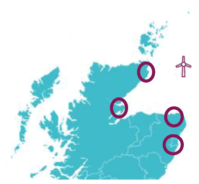
- At this stage ports have not been selected. The developer has a short list of potential operational ports (Fraserburgh, Aberdeen, Wick) and construction ports (Port of Nigg, Wick)
- There will be minimal visibility of the offshore infrastructure because of the distance to shore
- The onshore landing site has been selected on the Aberdeenshire coast and the substation will be in Rosehearty. The visibility of the onshore infrastructure will cover a 10km radius
What are the political and economic organisations that represent the epicentre locations?
- Caithness and North Sutherland Regeneration Partnership
- Opportunity North East
- Highland Council
- Aberdeenshire Council
- Aberdeen City Council
- Highlands and Island Enterprise
- Scottish Government
- Scottish Enterprise
What are the smallest of these areas with sufficient data available to analyse supply chain and investment imapcts?
- Highland Council
- Aberdeenshire Council
- Aberdeen City Council
Do communities in these areas recognise these defined geographies
- Yes
Are additional geographies required to cnnect
- Yes, in order to create a continuous local area, it will be necessary to include Moray Council
Define Local Area based on these geographies
- The combined local authorities of Highland, Moray, Aberdeenshire and Aberdeen City
A similar process is required to identify the local area(s) used in the assessment of wider socio-economic impacts.
Wider Socio-economic Impact
Name: Firth Offshore Wind Farm
Type: Offshore Wind, Fixed
Timetable of Assessment: Assessment was undertaken in support of the planning application, at least 5 years before any construction has started.
What wider socio-economic impacts will be considered as part of this study?
- Tourism Impacts
- Recreation Impacts (including sailing)
- Fishing and Marine Economy
What are the epicentres of these impacts?
- Visibility of onshore infrastructure
- Visibility of offshore infrastructure
- Offshore infrastructure
Where are these epicentres located?
- At this stage ports have not been selected. The developer has a short list of potential operational ports (Fraserburgh, Aberdeen, Wick) and construction ports (Port of Nigg, Wick)
- There will be minimal visibility of the offshore infrastructure because of the distance to shore, however the offshore site will be visible to offshore recreational sailors based in Wick, Stromness or Kirkwall
- The onshore landing site has been selected on the Aberdeenshire coast and the substation will be in Rosehearty. The visibility of the onshore infrastructure will cover a 10km radius
What are the political and community organisations that represent the epicentre locations?
- Aberdeen City Council
- Orkney Council
- Highland Council
- Fraserburgh Community Council
- Kirkwall and St Ola Community Council
- Rosehearty Community Council
- Nigg and Shandwick Community Council
- Stromness Community Council
- Wick Community Council
What are the smallest of these areas with sufficient data available to analyse wider socio-economic impacts?
- Fraserburgh Community Council
- Kirkwall and St Ola Community Council
- Rosehearty Community Council
- Nigg and Shandwick Community Council
- Stromness Community Council
- Wick Community Council
Do communities in these areas recognise these defined geographies
- Yes
Define Local Areas based on these geographies
- The separate local areas of
- Fraserburgh Community Council
- Kirkwall and St Ola Community Council
- Rosehearty Community Council
- Nigg and Shandwick Community Council
- Stromness Community Council
- Wick Community Council
4.2 Example Project 2 - Kinlochaline Fish Farm
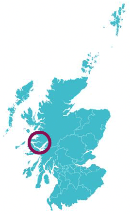
This example is of a hypothetical fish farm proposal based close to the shoreline by Lochaline in the Sound of Mull.
The first principle is of dual geography. Therefore, the Investment and Supply Chain Impacts should be considered separately from the Wider Socio-Economic Impacts. The two tables below highlight the process through which the principles will lead to defined local areas.
Supply Chain and Investment Impact

Name: Kinlochaline Fish Farm
Type: Aquaculture
Timetable of Assessment: Assessment was undertaken in support of the planning application, at least 1 year before any construction has started.
What supply chain and investment impacts will be considered as part of this study?
- Direct Jobs & GVA
- Multiplier Jobs & GVA
- Fragile Economies
What are the epicentres of these impacts?
- Fish farm site;
- Construction/Assembly Port
- Operational to the fish farm
Where are these epicentres located?
- Fish farm site - Lochaline;
- Construction/Assembly Port - Oban
- Operational port for the fish farm - Lochaline
What are the political and economic organisations that represent the epicentre locations?
- Scottish Parliament constituencies of Skye Lochaber and Badenoch and Argyll and Bute
- UK Parliament constituencies of Ross, Skye and Lochaber and Argyll and Bute
- Highland Council
- Argyll and Bute Council
- Oban Harbour Management Group
- Oban Community Council
- Morven Community Council
What are the smallest of these areas with sufficient data available to analyse supply chain and investment imapcts?
- Parliamentary Constituencies
Do communities in these areas recognise these defined geographies
- Yes
Are additional geographies required to connect
- No
Define Local Area based on these geographies
- Combined UK Parliament Constituencies of Ross, Skye and Lochaber and Argyll and Bute
A similar process is required to identify the local area(s) used in the assessment of wider socio-economic impacts.
Wider Socio-economic Impact
Name: Kinlochaline Fish Farm
Type: Aquaculture
Timetable of Assessment: Assessment was undertaken in support of the planning application, at least 1 year before any construction has started.
What wider socio-economic impacts will be considered as part of this study?
- Tourism Impacts (Inc Oban to Tiree Ferry and Fishnish to Lochaline Ferry)
- Recreation Impacts
- Demographic Changes/Vulnerabilities
- Fragile Economies
- Fishing and Marine Economies
What are the epicentres of these impacts?
- Fish farm site - Lochaline
- Construction/Assembly Port; - Oban
- Operational port for the fish farm - Lochaline
- Visibility of offshore infrastructure - A radius around the fish farm including Morven and Mull
Where are these epicentres located?
- Fish farm site - Lochaline
- Construction/Assembly Port - Oban
- Operational port for the fish farm - Lochaline
- Visibility of offshore infrastructure - A radius around the fish farm including Morven and Mull
What are the political and community organisations that represent the epicentre locations?
- Morvern Community Council
- Mull Community Council
- Oban Community Council
What are the smallest of these areas with sufficient data available to analyse wider socio-economic impacts?
- The population and employment by broad sector is available for areas approximating the community council area
Do communities in these areas recognise these defined geographies
- Yes
Define Local Areas based on these geographies
- Three separate areas of Morven, Oban and Mull
Contact
Email: ScotMER@gov.scot