Clyde cod spawning closure Spring 2024/25: consultation
Since 2001, a specific area in the Firth of Clyde has been closed to fishing each year between 14 February and 30 April in order to protect spawning cod. This consultation is seeking views on the continuation of this closure for 2024 and 2025.
Annex A
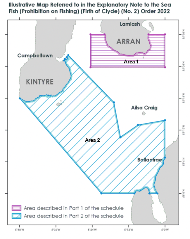
Area 1 – North Area GPS coordinates
Point A - 55° 30.000' N, 005° 05.472' W
Point B - 55° 30.000' N, 005° 00.000' W
Point C - 55° 23.820' N, 005° 00.000' W
Point D - 55° 23.820' N, 005° 24.600' W
Point E - 55° 30.000' N, 005° 24.600' W
Point F - 55° 30.000' N, 005° 19.947' W
Area 2 – South Area GPS coordinates
Point A - 55° 25.713' N, 005° 32.426' W
Point B - 55° 26.100' N, 005° 31.920' W
Point C - 55° 17.220' N, 005° 16.860' W
Point D - 55° 10.680' N, 005° 14.700' W
Point E - 55° 12.960' N, 005° 08.940' W
Point F - 55° 13.860' N, 005° 00.000' W
Point G - 55° 06.797' N, 005° 00.000' W
Point H - 55° 00.000' N, 005° 02.496' W
Point I - 55° 00.000' N, 005° 05.170' W
Point J - 55° 00.000' N, 005° 10.120' W
Point K - 55° 00.000' N, 005° 21.000' W
Point L - 55° 17.962' N, 005° 47.914' W
Point M - 55° 25.088' N, 005° 33.303' W
Point N - 55° 25.392' N, 005° 33.065' W
Contact
Email: clydecodclosure@gov.scot