Scottish island regions 2023: overview
The Scottish Island Regions (2023) report describes a new geography which could be used as a basis to reframe existing data or collect new data. Having more data on islands will help our understanding of the issues faced by the population of Scotland’s islands.
Scottish Island Regions (2023): Overview
Introduction
This is a brief guide to the Scottish Island Regions (2023) – a new geography for grouping Scotland’s islands into nine different island regions. This new geography is based on the Scottish Island Regions Framework (2020) (Annex 1) initially developed by the James Hutton Institute (JHI) and used as the basis for the National Islands Plan Survey (2020). Both have nine different island regions. In order to ‘future-proof’ the geography, and prevent regular updates being required as islands switch inhabited status, it was agreed that the geography would be updated.
At the time of the 2011 Census, 93 of Scotland’s islands were recorded as having at least one resident. However, many of the islands are very sparsely populated. This presents a challenge in both collecting and analysing data on Scotland’s island population. Grouping islands together into regions is one feasible way to conduct research on the Scottish island population despite these challenges.
This report is organised into the following sections:
1. The revised Scottish Island Regions (2023)
2. National Records of Scotland (NRS) Islands excluded from the Scottish Island Regions (2023)
3. Differences between James Hutton Institute (2020) and Scottish Island Regions (2023)
4. Conclusion
5. Other resources
6. Annex 1: James Hutton Institute Scottish Island Regions (2020)
Map of Scottish Island Regions (2023)
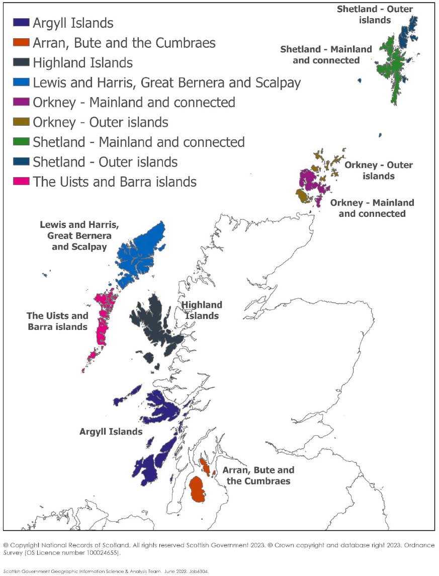
Scottish Island Regions (2023)
The James Hutton Institute geography (2020) was revised to include all Scottish Islands (Source: NRS Islands) which are currently, or previously have been, inhabited and therefore have been assigned a unique three-digit code. The National Records of Scotland (NRS) islands within each Scottish Island Region are shown in the table below (alternative names have been excluded for brevity).
Argyll Islands
Calve Island, Cara Island, Coll, Colonsay, Dubh Artach, Easdale, Eilean an Stalcaire, Eilean Buidhe, Eilean dà Mhèinn, Eilean Loain, Eilean Musdile, Eriska, Erraid, Gometra, Inch Kenneth, Iona, Island Davaar, Islay, Isle of Danna, Isle of Gigha, Isle of Mull, Jura, Kerrera, Lismore, Little Colonsay, Luing, Lunga (Luing), Oronsay, Orsay, Rubha Fiola, Rubha nan Gall, Sanda Island, Scarba, Seil, Shuna (Luing), Shuna Island (Lismore), Skerryvore, Texa, Tiree, Torsa, Ulva
Arran, Bute and the Cumbraes
Bute, Great Cumbrae Island, Holy Island, Inchmarnock, Isle of Arran, Little Cumbrae Island, Pladda
Highlands Islands
Canna, Carna, Cnoc na h-Airigh, Cnoc nan Uibhean, Eigg, Eilean Ban, Eilean Donnan, Eilean Dubh, Eilean Fladday, Eilean Horrisdale, Eilean Shona, Eilean Tioram, Island of Stroma, Isle Martin, Isle of Ewe, Isle of Raasay, Isle of Skye, Muck, Ornsay, Pabay, Rona / Ronaigh (Skye), Rum, Sanday (Canna), Scalpay (Skye), Soay, Tanera More
Lewis and Harris, Great Bernera and Scalpay
Boreray (St Kilda), Eilean Mòr (Flannan Isles), Ensay, Goat Island, Great Bernera, Isle of Lewis, Pabbay, Scalpay (Harris), Scarp, St Kilda or Hirta, Taransay
Orkney - Mainland and connected
Burray, Lamb Holm, Mainland of Orkney, South Ronaldsay
Orkney Outer Isles
Auskerry, Cava, Copinsay, Eday, Egilsay, Fara, Flotta, Gairsay, Graemsay, Helliar Holm, Holm of Grimbister, Hoy, Inner Holm, Muckle Skerry (Pentland Skerries), North Ronaldsay, Papa Stronsay, Papa Westray, Rousay, Sanday (Orkney), Shapinsay, Stronsay, Sule Skerry, Swona, Westray, Wyre
Shetland - Mainland and connected
East Burra, Mainland of Shetland, Muckle Roe, Trondra, West Burra
Shetland Outer Isles
Bressay, Bruray, Fair Isle, Fetlar, Foula, Grunay, Housay, Isle of Noss, Muckle Flugga, Papa Stour, Unst, Vaila, Whalsay, Yell
The Uists and Barra Islands
Baleshare, Barra, Benbecula, Berneray (North Uist), Berneray (Vatersay), Boreray, Kisimul Castle, Eilean a' Ghiorr, Eilean Leathann, Eilean Leireabhagh, Eilean Mhidhinis, Eilean na Cille, Eilean na h-Airigh, Eriskay, Flodaigh, Fraoch-eilean, Grimsay (North), Grimsay (South), Lingeigh, Mingulay, North Uist, Orasaigh, Ronay, Shivinish, South Uist, Sunamul, Vatersay
Scottish Islands excluded from the Scottish Island Regions (2023)
The Scottish islands which are included in the National Records of Scotland Island product with a unique three-digit code, but excluded from the Scottish Island Regions (2023), are listed below.
These islands are excluded either because they do not meet the definition of an Island, as defined in the Islands (Scotland) Act 2018.
“a naturally formed area of land that is surrounded on all sides by the sea ignoring artificial structures e.g. bridges, and is above water at high tide”.
and/or they are not in one of the six Local Authorities, Argyll and Bute, Comhairle nan Eilean Siar, Highland, North Ayrshire, Orkney Islands, Shetland Islands, that contain islands as defined by the Islands (Scotland) Act 2018.
| Name | NRS Code |
|---|---|
| Ailsa Craig | 001 |
| Ardwall Isle | 003 |
| Bass Rock | 008 |
| Buchanness Lighthouse | 171 |
| Friarton or Moncreiffe Island | 088 |
| Inch | 002 |
| Inchcape / Bell Rock | 009 |
| Inchcolm | 065 |
| Inchconnachan | 066 |
| Inchcruin | 150 |
| Inchfad | 067 |
| Inchkeith | 068 |
| Inchlonaig | 152 |
| Inchmahome | 168 |
| Inchmurrin | 070 |
| Inchtavannach | 071 |
| Innis Chonain | 072 |
| Isle of May | 087 |
| Mainland Scotland | 000 |
Differences between James Hutton Institute Scottish Island regions (2020) and the Scottish Island Regions (2023)
Changes are listed below.
2023 Scottish Island Region names (previous 2020 names)
Highlands Islands (previously Skye and the Small Isles)
Lewis and Harris, Great Bernera and Scalpay (previously Lewis and Harris)
Orkney – Mainland and connected (previously Orkney Mainland)
Shetland – Mainland and connected (previously Shetland Mainland)
The Uists and Barra Islands (previously Uist and Barra)
Islands which have a unique three-digit NRS Island code which have been added to the 2020 geography to create the Scottish Island Regions (2023).
Carna, Eilean Donnan, Island Davaar, Island of Stroma, Sanda Island, Calve Island, Cara Island, Dubh Artach, Eilean an Stalcaire, Eilean Loain, Eilean Musdile, Inch Kenneth, Little Colonsay, Lunga (Luing), Orsay, Scarba, Shuna Island (Lismore), Skerryvore, Texa, Torsa, Inchmarnock, Little Cumbrae Island, Pladda, Boreray (St Kilda), Eilean Mòr (Flannan Isles), Ensay, Goat Island, Pabbay, Scarp, St Kilda or Hirta, Taransay, Lamb Holm, Cava, Copinsay, Fara, Helliar Holm, Muckle Skerry (Pentland Skerries), Papa Stronsay, Sule Skerry, Swona, Grunay, Isle of Noss, Muckle Flugga, Cnoc na h-Airigh, Cnoc nan Uibhean, Eilean Ban, Eilean Dubh, Eilean Fladday, Eilean Horrisdale, Ornsay, Pabay, Berneray (Vatersay), Kisimul Castle, Eilean Leireabhagh, Eilean Mhidhinis, Eilean na Cille, Lingeigh, Mingulay, Orasaigh, Ronay, Shivinish
The rationale for including the extra National Records of Scotland (NRS) islands listed on the previous page in the Scottish Island Region (2023) geography is detailed below.
The rationale for including all National Records of Scotland (NRS) Islands which are currently, or have previously been, inhabited is to ensure a consistent methodology has been applied across the six Local Authorities. Note that National Records of Scotland (NRS) define an island as currently or previously inhabited if there is at least one Royal Mail Unique Delivery Point Reference Number (UDPRN) on the island. The islands which NRS currently, or have previously, classed as inhabited can be easily identified as they have been assigned a unique three-digit code by NRS between 000 and 180.
Using the currently and previously inhabited islands from the NRS Island product as the sub-set of islands for inclusion, rather than the 100 which were originally used by JHI, will help to future-proof the geography and ensure that it does not need to be regularly updated as UDPRNs are added to or removed from islands and their inhabited statuses change. The only time that it should therefore be necessary to update the Scottish Island Regions geography is if an island which has not previously been classed as inhabited by NRS gets assigned a Royal Mail UDPRN, and is therefore given the next unique three-digit code by NRS (which will be code 181).
A lookup is available for all 180 islands which have been assigned unique three-digit codes by NRS (note that one unique code between 000 and 180 has been retired for an island which is now joined to the mainland through reclaimed land creating a causeway).
Conclusion
The new Scottish Island Regions (2023) geography can help to reframe existing data and collect new data. Having more data on islands will help our understanding of the issues faced by the population of Scotland’s islands. This new geography allows comparability in data between the Scottish islands and the Scottish mainland.
Other resources
Interactive charts are available, showing population change by age and sex, for the Scottish Island Regions. Mid-year population estimates for Scottish Island Regions are also now available from National Records of Scotland.
The Geographic Information Science & Analysis Team (GI-SAT) at the Scottish Government have published boundaries and assigned S-codes to the new Scottish Island Regions geography, enabling it to be used by a wider audience. These are available on the spatial data metadata portal and via the Scotland Register of GSS Codes.
The Scottish Island Regions are based on the Scottish islands framework initially created by the James Hutton Institute for the National Islands Plan Survey (2020). For details, see: National Islands Plan Survey - Final Report.
For more information on the Scottish Island Regions (2023), please contact: info@islandsteam.scot or SSDI.Metadata@gov.scot
Acknowledgements
The researchers would like to thank Jonathan Hopkins, James Hutton Institute, for developing the original framework while conducting the Scottish National Islands Plan Survey on behalf of the Scottish Government. This survey was led by Ruth Wilson and Jonathan Hopkins. We are also grateful to the National Islands Plan Survey Research Advisory Group for their feedback on the initial framework, and for the work of Q-Step interns Joanna Mroczka, Andriani Klefti and Sean Choon in matching the framework to Data Zones. Q-Step is funded by the Nuffield Foundation and Economic and Social Research Council (ESRC).
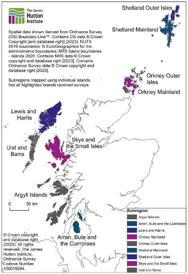
Annex 1: James Hutton Institute Scottish Island Regions (2020)
The James Hutton Institute framework grouped Scotland’s islands into 9 distinct subregions, as illustrated on this map (detail here).
The subregions were created from individual islands from the NRS Islands 2020 product which were identified as potentially populated, based on postcode information in the 2020 NRS Scottish Postcode Directory. All the islands which were selected for inclusion were classed as inhabited, based on the 2020_2 Scottish Postcode Directory (i.e. they contained at least one Royal Mail Delivery Point).
Contact
Email: SSDI.Metadata@gov.scot