Delivering sustainable flood risk management: guidance
Sets out statutory guidance to SEPA, local authorities and Scottish Water on fulfilling their responsibilities under the Flood Risk Management (Scotland) Act 2009.
2. Understanding and working with catchments
Introduction
Actions that affect one part of a river or coastline can have consequences elsewhere. This means that flood management measures are most effective when they are coordinated across catchments and along coastlines in a way that is uninhibited by administrative boundaries.
Adopting a catchment approach to flood risk management requires an appreciation of catchment and coastal processes, and an understanding of how best to manage the sources and pathways of flood water. This includes looking at how the timing, magnitude and duration of a flood event can be altered by creating, restoring and enhancing natural features and characteristics of the landscape, including wetlands, vegetation and functional flood plains.
This section provides guidance on:
- setting appropriate units of management;
- the application of a source-pathway-impact approach to flood risk management;
- the role of land use and positive management in managing flood risk including measures in urban areas;
- promoting and balancing the needs of those living and working in rural areas.
Catchment management units
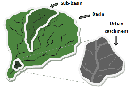
SEPA and the responsible authorities must coordinate their actions to tackle flood risk across catchments. In most cases this will require coordination of actions at the scale of the river basin- i.e. a catchment that drains to the sea (Figure 3).
This is a move away from the traditional approach which has been undertaken within administrative boundaries. It is important that the issues arising as a result of working across administrative boundaries are addressed. SEPA and the responsible authorities need to work together to develop the catchment approach.
In some cases it may be appropriate to sub-divide river basins into smaller catchments (also referred to as sub-basins) to allow for more detailed assessment and analysis of management options. When assessing options to tackle urban surface water flooding, small urban drainage catchments can be defined to promote detailed analysis of the urban landscape as long as it is considered as part of the wider catchment.
Where river basins are separated into smaller catchments, all the interactions, physical and ecological, with the larger river basin in which they are located must be understood.
Figure 3 Basins, sub-basins and urban catchments
SEPA should work closely with the other responsible authorities to identify the appropriate spatial scales and catchments around which flood risk management efforts should be targeted.
Many of the principles that apply to catchments also apply to coastal areas, with actions in one place potentially affecting other areas of the coastline. In identifying appropriate management units for coastal areas, SEPA should give careful consideration to coastal and estuarine processes and interactions between coastal areas and catchments.
Understanding catchments
Our natural landscape can play an important role in managing flood risk. Over time, human activities have altered the character of our landscape and affected the timing, magnitude and duration of flood events. For example, urban creep, compacted soils, changes in land cover and increased field drainage can all increase run-off and peak flood flows.
Creation, restoration and enhancement of natural features of the landscape (e.g. flood plains, wetlands and forests etc) can help to restore more favourable run-off patterns and reduce flood risk;
These more natural techniques typically protect, emulate or restore the natural processes which regulate flooding and erosion, often by keeping water in areas where it will cause less damage. Examples include:
- improving water storage and capturing run-off by restoring, protecting or enhancing soil condition and woodland areas;
- reconnecting floodplains, restoring wetlands or creating ponds and reservoirs to helps store flood waters;
- planting vegetation and managing hill slopes to help slow run-off;
- restoring watercourses to a more natural channel form by removing culverts and other structures that constrain channels and contribute to flooding during high flows;
- reducing the pressure of sea level rise and coastal erosion through managed realignment or regulated tidal exchange.
In urban areas, green roofs, permeable paving, flood and surface water attenuation ponds, opening up and realigning watercourses, and establishing green spaces and blue corridors are equivalent examples.
To provide insights into the causes of flooding and the types of management options available, SEPA, in close collaboration with the responsible authorities and other organisations with an interest in catchment management, should work to develop an improved understanding of the hydrological, ecological and geo-morphological condition and functioning of Scotland's catchments. This should include assessments of the effects of human interventions on flooding processes.
The condition of our soils, our water resources and the health of our ecosystems are all influenced by processes that occur within and across catchments and coastlines. Understanding and managing these interactions will create opportunities to invest in actions that can simultaneously reduce the risk of flooding, while also improving the quality of our natural and urban environment. SEPA should ensure that information generated on catchment characteristics and natural features can be used to support other work areas, including River Basin Planning and the selection and design of environmentally sensitive engineered defences or other measures.
SEPA is also responsible for assessing how the restoration or enhancement of natural features and characteristics of catchments could contribute to managing flood risk. In preparing these assessments, SEPA should work to create information that can be used in the appraisal of flood management options. SEPA should also work to identify any additional costs or benefits that can be delivered from these actions, thus ensuring that the full value of these options can be considered.
State of knowledge and using reliable science
The state of knowledge on these natural techniques is still evolving. Robust and reliable science must be applied at all stages of flood risk management. SEPA should draw on its environmental and hydrological expertise so as to advise its partners and the wider stakeholder community on the benefits and role of these techniques. This should include supporting research and promoting demonstration projects.
The uncertainties associated with using more natural approaches have been greater than those for more traditional engineering. It is expected that these uncertainties will diminish as the evidence base expands, and these uncertainties should not be viewed or used as a barrier to adopting these techniques.
SEPA and the responsible authorities must ensure that these uncertainties are examined and communicated to those who may benefit or be affected by the use of these techniques.
Promoting and balancing the needs of rural areas
Rural land use is important to the Scottish economy. There are many and varied demands already placed on land managers, and rural land use contributes to delivering many wider economic, environmental and social benefits, with a large number of people directly employed in these sectors. A large proportion of Scotland's land is under agricultural production and the sector is responsible for much of Scotland's domestic food supplies and exports.
Some of the greatest opportunities to restore our landscapes natural capacity to cope with floods are in rural areas. However, compromising important areas of agricultural production or forestry could have serious impacts on rural economies and food production, particularly considering that Scotland is not self sufficient in food production. In preparing flood risk management plans, SEPA and local authorities should consider carefully the views and needs of land owners and rural businesses so that the correct balance is struck between all competing demands on rural areas.
It is important that land management changes are focused at a scale/ distance that is relevant to the area at risk of flooding.
Some funds are available to support voluntary action, including the Scotland Rural Development Programme ( SRDP) and SEPA's restoration fund. The SRDP supports sympathetic management of land by promoting actions that reduce the effects of pollution, deliver biodiversity benefit, flood management and other societal and environmental benefits. However, due to competition from other policy areas, their contribution to flood risk management is likely to be limited.
SEPA and the responsible authorities should consider carefully how the range of existing funding routes and instruments can be used to support flood management and wider restoration initiatives and, in particular, the new local authority powers under the Act can be used to deliver flood risk reductions through land management. For example, in allocating funding for environmental improvements SEPA should give consideration to promoting projects that deliver coincident flooding and environmental benefits.
Where land management and restoration forms part of a flood protection scheme, local authorities have a new wide range of powers to compensate land owners/managers. Options include one off payments, service agreements and compulsory land purchase. In all cases voluntary action or voluntary agreements should be pursued. However, the voluntary agreements still need to be set down in a legal framework which gives both parties security.
The Scottish Government will continue to work with stakeholders and local authorities to ensure that local authorities have access to a toolkit of options for delivering improved flood risk management and a reduction in flood risk. Particular attention will be paid to any limitations of current instruments and to instruments that encourage land owners to participate through voluntary actions.
There is a problem
Thanks for your feedback