Spread of invasive species into Scotland: study
A horizon scanning study involving analysis of pathways of spread of invasive non-native species into Scotland. It considers species having the highest likelihood of arrival and establishment and the magnitude of their potential negative impact on biodiversity and ecosystems over the next 10 years.
Introduction
Invasive non-native species (INNS) are one of the major threats to biodiversity and ecosystem services (Díaz, Settele et al. 2019) and interact with other drivers of biodiversity change including notably climate change and land- or sea-use change (Bonebrake, Guo et al. 2019). The number of non-native species being introduced to new regions around the world is increasing year on year (Seebens, Blackburn et al. 2017). Preventing the arrival and spread of a subset of these non-native species that present the greatest threat, so called INNS, is seen as a priority in the Scottish Biodiversity Strategy[1] and indeed worldwide.
Here we present the outcomes of a short project comprising two main tasks:
i) horizon scanning for INNS that are likely to establish and impact on biodiversity within the next 10 years but are not yet established in Scotland; and
ii) comprehensive analysis of pathways of introduction and spread of new INNS into Scotland.
Horizon scanning, a systematic examination of potential threats and opportunities, can inform prevention strategies including development of pathway action plans, which identify measures to reduce the risk of new INNS introductions and spread, and biosecurity approaches. There are many possible ways to undertake horizon scanning (Roy, Schönrogge et al. 2014); they include consensus methods developed and implemented by the project team (Roy, Peyton et al. 2020). This involves a two-stage approach:
1. Expert groups (marine, freshwater, terrestrial invertebrates, terrestrial plants and terrestrial vertebrates) compile long lists of INNS that are likely to arrive and establish within a region and have a negative impact on native biodiversity and ecosystems within the next 10 years. The expert groups gather information and evidence, through literature and other searches to inform rapid assessment, for the agreed long list of potential INNS;
2. Expert elicitation workshops combine the outputs from the expert groups to ultimately derive a ranked list of INNS spanning all taxonomic groups.
This approach has been implemented for Great Britain (Roy, Peyton et al. 2014), Europe (Roy, Bacher et al. 2019), Ireland (Lucy, Davis et al. 2020), Cyprus (Peyton, Martinou et al. 2019, Peyton, Martinou et al. 2020) and the United Kingdom (UK) Overseas Territories[2] (Hughes, Pescott et al. 2020, Dawson, Peyton et al. 2023). Guiding principles (Roy, Peyton et al. 2020) have been published to assist the process. In these guiding principles, it is noted that is essential to include experts with a diverse range of knowledge across the various environments and taxonomic groups to ensure effective delivery of the horizon scanning.
INNS can arrive in Scotland through overseas trade and travel, which may potentially be controlled through enhanced biosecurity measures. For these species, recent horizon scanning exercises completed for Great Britain in 2019 were highly relevant. There are, however, many non-native species established in other parts of Great Britain that have yet to spread to Scotland that require specific attention while also noting that there are species that are native within the UK but non-native in Scotland. The list of Prevention Priority Species (2016) adopted by the Scottish Non-Native Species Action Group was also informative for the horizon scanning.
Scotland’s context
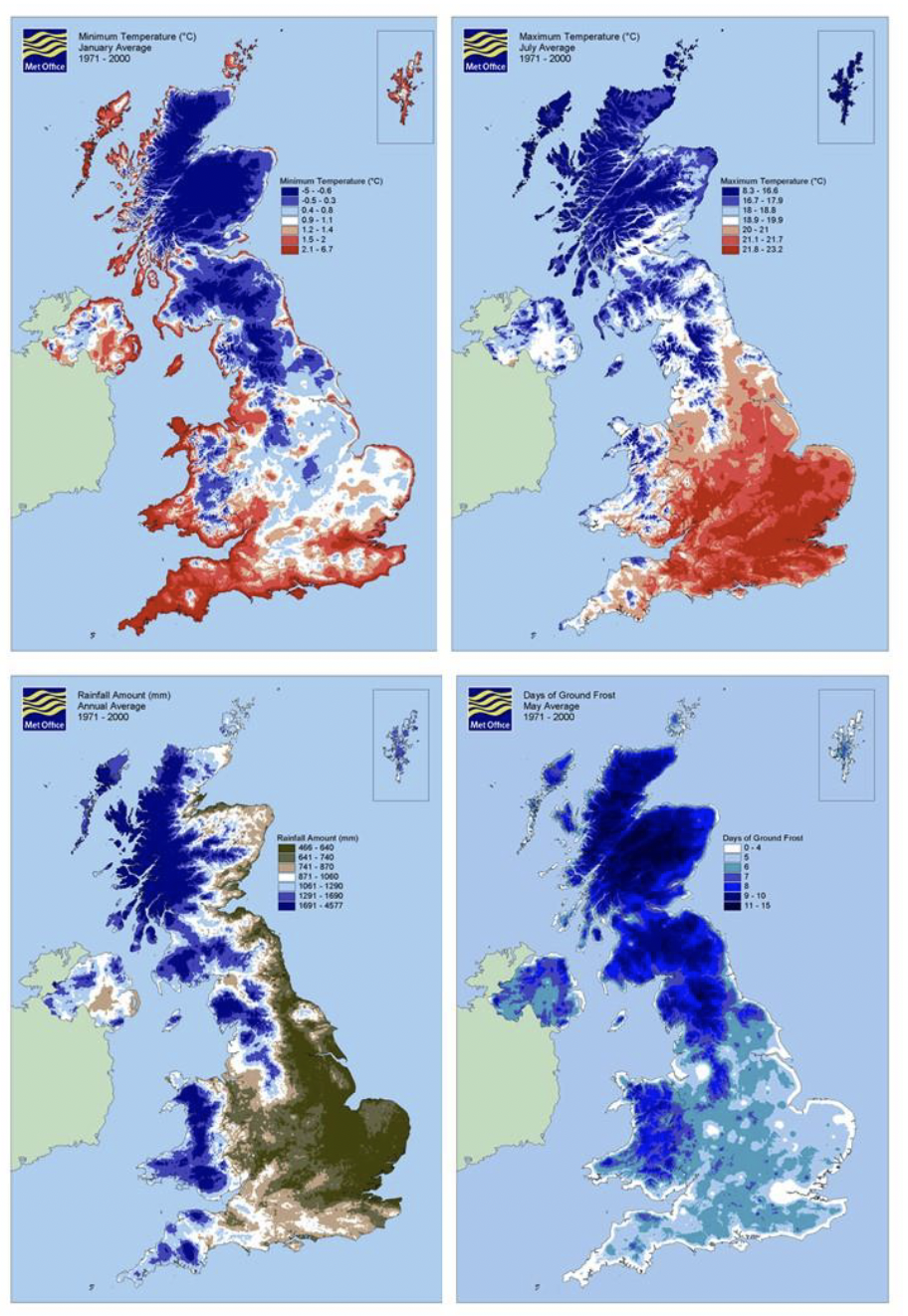
Scotland generally has a cooler and wetter climate than the rest of Great Britain (Figure 1) with average (1971-2000) minimum temperatures in January of -0.2 °C, compared to 1.1 °C in England and maximum July temperatures of 16.9 °C compared with 20.6 °C in England[3]. Winter temperatures are warmer on the west coast of Scotland and are comparable to those recorded in western parts of England and Wales (Figure 1). Average annual rainfall levels are drier on the east coast of Scotland and are more comparable with many regions of England. Apart from the very fringes of the west coast, Scotland experiences many more ground frost days in late spring, with, on average (1971-2000), eight or more ground frost days in May. This may particularly limit the distribution of frost-sensitive INNS. Despite these generalised differences, it is also clear that southern regions of Scotland have very comparable climates to northern England and climate is only likely to broadly limit the spread of INNS within Scotland, not the establishment of species that are already present in northern England.
Scotland’s geology and soils are most distinct for the Highlands and Islands region. Here they are dominated by igneous rocks and have more peaty and acidic soils than the rest of Great Britain, whereas the Central Lowlands and south of Scotland have comparable rock and soil types to those found in much of England and Wales.
The rate of arrival and establishment of INNS is influenced by socio-economic factors such as human population density, economic development, trade and transport and tourism. Scotland has a population of 5.4 million (8% of the UK total), of which 80% live in the Central Lowlands5. The propagule pressures from INNS are likely to be greater in the Central Lowlands, which have a human population density comparable to much of England and Wales, than in the Highlands and Islands and southern Scotland where the human population density is less than one tenth of the UK average[4].
The majority of goods entering Scotland are transported by road from or via other parts of the UK. This underlines the importance of the joint nations approach to managing pathways for introduction and spread of INNS under the GB INNS Strategy. Four major ports (Forth, Clyde, Sullom Voe and Glensanda) account for almost 90% of the international freight tonnage entering and leaving Scotland, which is mostly oil and gas and aggregates. The main sea freight partners are the EU (60%), Asia (22%,) and Africa (8%) (Transport Scotland 2019). International trade in live plants involving the large-scale movements of material for the agricultural, forestry and horticultural industries has been implicated in the unintentional introduction of many INNS globally including, as examples, oak processionary moth (Thaumetopoea processionea) and ramorum blight (Phythopthora ramorum) to the UK (Marzano, Dandy et al. 2015). The horticultural industry is estimated to support 64,000 jobs and contribute approximately £2.8bn to GDP in Scotland (Horticultural Trades Association, 2023). The Scottish Horticultural Growth Strategy highlights the importance of biosecurity to “enhance and protect Scotland’s Natural Capital”.
Tourism is one of seven growth industries in Scotland, contributing around £6 billion (5%) to Scottish GDP (Scottish Government, 2018). The natural environment is a key tourism asset with spending on nature-based tourism estimated to contribute nearly 40% of the total (Bryden 2010). Nature-based tourism activities are widely spread across the whole of Scotland. The risk of introduction of INNS via pathways associated with these activities is linked to the type of activity, the number of visitors, and the preventative steps taken to reduce the risk.
One distinct difference between Scotland and the rest of Great Britain is the relatively unregulated, open access allowed for recreation and tourism across much of the Scottish landscape. This includes water sports access on rivers and lochs (lakes) although noting that there are restrictions relevant to salmon fishing[5]. Social inclusion in access to the natural environment may create additional challenges for managing pathways of introduction and spread of INNS associated with recreational activities.
Contact
There is a problem
Thanks for your feedback