Driven grouse moors - socioeconomic and biodiversity impacts: summary report
A summary report of findings from research into socioeconomic and biodiversity impacts of driven grouse moors and the employment rights of gamekeepers
7. Part 3- Mapping the areas and management intensity of moorland actively managed for grouse
Background
The 'Phase 2' research updates and enhances the work reported by Matthews et al. (2018) in Phase 1, where geographical information system (GIS) and remote sensing methods were used to identify areas of driven grouse moors and assess their potential for alternative land uses. As part of the Phase 1 analysis, assessments were also made of the intensity of moorland management. An assessment of grouse butt density (number per km2) was made for the first time, but the assessment of strip burning of heather relied on data from 2005-11. This meant that the Phase 1 analysis could provide no insights into changes in strip burning of heather that have occurred in the last decade. The Phase 2 analysis has addressed this limitation by providing updated (to June 2018) and higher resolution mapping of strip burning. The characterisation of grouse butt density was also enhanced by making an improved assessment of the areas of rough grazing that are close to the locations of grouse butts. This section provides a summary of the full technical report for Part 3.
Improvements to the available data and methods
The project has collected new data for all agricultural holdings identified in Phase 1 as having grouse butts present and rough grazing, by undertaking the following six steps:
1. Updating the mapping of strip burning from 2005-11 to June 2018 – interpreting aerial photography or high-resolution satellite data.
2. Adding a "burned since" date by comparing 2018 with earlier imagery to quantify the likelihood that strip burning of heather moorland continues to be active rather than being a relict feature.
3. Improving the spatial resolution of strip burning analysis from a 1km to a 200m grid allowing the attribution of areas of burning to specific holdings. This attribution means it is now possible for the first time to look at the distribution of burning areas and intensity across all land holdings.
4. Identifying where there may have been a change in intensity of burning by comparing 2018 data with that from the 2005-11 analysis. Any comparison needs to be made carefully given the differences in the methods and data used but indicative conclusions can be drawn.
5. Defining areas more likely to be subjected to management for driven grouse, by identifying rough grazing within set distances of grouse butts (500m to 2,000m) as being those more likely to be subjected to some form of management for driven grouse. This gives a more robust estimation of the area of driven grouse management with quantified levels of uncertainty. This method eliminates from consideration large areas of rough grazing in holdings that are remote from grouse butts and had in the Phase 1 analysis inflated the overall area associated with driven grouse moors and underestimated the intensity of management being practiced.
6. Improving the estimation of grouse butt density (butts per km2) using data from (5) above) as another indicator of intensity of management.
Taken together the six steps enable the creation of a single unified dataset integrating land cover/use, area and intensity of burning, grouse butt numbers and their density and the other characterisation data taken from the Phase 1 analysis. From this dataset, deductions about the number and characteristics of holdings, engaged in driven grouse moor management can be made.
Caveats to the analysis
While the analysis conducted has improved on the Phase 1 and earlier analyses, there are still limitations. Specifically, it was not possible to reinterpret all the potential areas in Scotland where burning could be occurring. Reinterpretation was therefore prioritised in locations where burning was present in both of the previous burning studies by RSPB (Douglas et al., 2015) and James Hutton Institute (McLeod and Newey, 2018). For the areas present in only one of these studies, another supplementary strip-burning analysis project was undertaken funded by the Scottish Government's Strategic Research Programme (SRP) 2016-22, starting in January 2020 and completed in March 2020. Digital datasets are supplied to the Scottish Government.
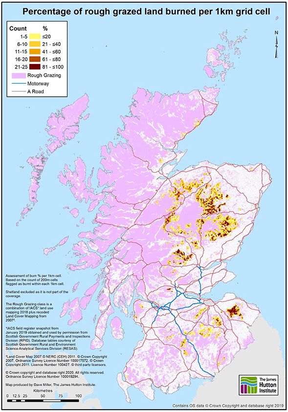
Summary Map
The map in Figure 1 provides a high-level summary of the analysis of driven grouse moor management within the project. The figure uses a heat map to show the locations, area and intensity of management, in terms of both grouse butt density and percentage of rough grazing area being burned. The heat map highlights relative intensity of grouse moorland management - from low intensity blues to highest intensity yellows. Since the heat map summarises characteristics within a 10km radius circle, it provides a form of landscape level summary that is helpful in emphasising where there are concentrations of activity within Scotland - in this case highlighting the Cairngorms, Angus Glens and the Lammermuir Hills. The map can also be interpreted as showing the degree of certainty that an area had driven grouse moor management present, with the lower intensity areas potentially no longer being actively managed for driven grouse.

Mapping areas and management intensity - key findings
The total land area on the 491 holdings with grouse butts mapped on rough grazing was about 1 million hectares. Of the total area, 858,000 hectares were rough grazing with 584,000 hectares (68%) falling within 2 kilometres of grouse butts and 388,000 hectares (45%) within 1 kilometre. A substantial share of this rough grazing land (187,000 ha or 32% of the rough grazing within 2 kilometres of butts) was managed by 13 holdings, each with more than 10,000 hectares of rough grazing. The burned area of rough grazing for the 491 holdings was 163,000 hectares.
Active burning in 2018 was confirmed present on 79% of the holdings and 87% of area, and no active strip burning was found for only 11% of holdings and on 7% of the area. For the holdings without burning, the grouse butts present are likely remaining as a relict feature of previous land management. Where burning was identified as present, this was confirmed as having occurred typically after 2013 and in some cases since 2015, with smaller areas relying on older data.
There were changes in the intensity of management between the period of the RSPB analysis (2005-11) and 2018, with both increases and decreases in intensity apparent with regional variations and clusters of change. There is, though, a need to be cautious in interpreting local patterns due to differences in data and interpretation methods. Any definitive interpretation of change would require a more detailed analysis of individual holdings data.
Areas closer to grouse butts were being burned more intensively (i.e. they have higher ratios of burned to rough grazing area). Any estimation of intensity needs to be explicit on the assumptions about which areas of rough grazing within land holdings were included in the driven grouse moor area. For example, if the whole area of rough grazed land present in the holdings is used, then the burned percentage is 19%. If only the rough grazing within 2,000m of the grouse butts is used then the burned percentage increases to 25% and within 500m the burned percentage is 38%.
The distribution of burned percentages across holdings was biased towards lower intensities which may suggest that some of the holdings were largely inactive in terms of driven grouse. The holdings with higher grouse management intensity (those above 50% burned), though, made up 11% of the population and had burning intensity values more than twice, and up to four times, the median burn percentage of 19%. The holdings with more than 60% burned had about 34,000 hectares (22%) of the burned area on 35 holdings, for an average per holding burned area of about 960 hectares. Figure 2 illustrates the distribution of high strip burning intensity.
The grouse butt density values had a wide range of values from less than one per square kilometre to over 10 per square kilometre (and in rare cases considerably higher). The range of densities reflected the wide variety of ways in which driven grouse management can take place. There was a bias in the distribution towards lower grouse butt densities but there were 28 holdings with grouse butt densities over 10 per square kilometre and these were collectively managing a total of around 15,000 hectares of land. Were environmental harm being generated mainly on holdings with higher densities of grouse butts, then implementation of any monitoring regime could be simplified by prioritising the relatively small numbers of such holdings.
The threshold above which the density of grouse butts might be considered excessive will depend on the circumstances in which it occurs and how the butts are used. It is likely that there can be a range of management practices associated with holdings having broadly the same density of butts per hectare. Therefore, the utility of the analysis would seem to be in highlighting cases where it might be prudent to work with holding owners to ensure that any negative impacts can be minimised.
Confirming Phase 1 analysis
The findings from this research, while having updated and substantially improved on the analysis that was possible in Phase 1, are consistent with the findings of the earlier GIS-based analysis by Matthews et al. (2018) in Phase 1 of this project. Specifically, the analysis reconfirms the diversity of ways in which driven grouse moor management can be conducted. Within holdings, a grouse moor can, in area terms, be a dominant enterprise or near insignificant. In terms of intensity of management, grouse moors are highly variable with large differences even between neighbouring holdings. Overall, the land used for driven grouse has very limited potential for production-oriented agriculture and forestry enterprises, though other uses that do not rely on the biophysical productivity of the land may be viable. Part 1 of this Phase 2 project further considered alternative moorland uses.
Opportunities for further research and stakeholder engagement
The new datasets created within this research can serve as a baseline against which to assess future change in key aspects of driven grouse moor management. The data also has potential value as a training dataset for any computer-based methods being developed to monitor the extent and intensity of moorland strip burning in Scotland. There are several ways in which the analysis could be improved but to move beyond incremental improvements would rely on gaining access to privately held data on land management practices. This could be gained through co-operation with stakeholder and industry associations and/or by augmenting existing Scottish Government data gathering processes such as the June Census/December Survey or the Single Application Form.
Contact
Email: socialresearch@gov.scot
There is a problem
Thanks for your feedback