Offshore wind energy - sectoral marine plan: seabird tagging feasibility
How to undertake a seabird tagging study for species and colonies potentially impacted by the sectoral marine plan for offshore wind energy
This document is part of a collection
Special Protection Areas
St Abbs Head to Fast Castle
Existing Data
Kittiwake
Data collection was carried out in 2012, as part of the collaborative FAME and STAR tracking programmes (Wakefield et al., 2017) and 2021 as part of pre-construction data collection for an offshore wind farm (Table 11). In both years, birds were caught using a noose pole. In 2012, archival tags were taped to the back feathers of 15 birds. In 2021, remote download tags were used, with 26 taped to tail feathers and 13 glued to back feathers. Whilst the data collected as part of the FAME and STAR projects can be accessed from BirdLife International’s Seabird Tracking Database, the data collected as part of pre-construction work for offshore wind farms are not.
| Year | Capture method | Tag type | Average tag weight (g) | Attachment method | Tracking duration (days) | Sampling schedule | Number of birds | ||||
|---|---|---|---|---|---|---|---|---|---|---|---|
| 2012 | Noose pole | IgotU | 14.2 | Taped to back feathers | 2.6 | 1 min 40 sec | 15 | ||||
| 2021 | Noose pole | Pathtrack/UvA-BiTS | 4.0/9.0 | Taped to tail feathers/ glued to back feathers | 0.2 – 36.3 | 5 min/variable | 26/13 | ||||
Guillemot
In 2012, a single guillemot was tagged with an archival GPS device, which was taped to its back feathers (Wakefield et al., 2017) as part of the collaborative FAME and STAR tracking programmes. These data are freely available from BirdLife International’s Seabird Tracking Database.
| Year | Capture method | Tag type | Average tag weight (g) | Attachment method | Tracking duration (days) | Sampling schedule | Number of birds | ||||
|---|---|---|---|---|---|---|---|---|---|---|---|
| 2012 | Noose pole | IgotU | 17.1 | Taped to back feathers | 4.1 | 1 min 40 sec | 1 | ||||
Work planned for 2023 breeding season
RSPB have plans to deploy up to 50 GPS tags on kittiwakes within the St Abbs Head to Fast Castle SPA during the 2023 breeding season, subject to any restrictions imposed due to the impact of HPAI.
Consideration for future work
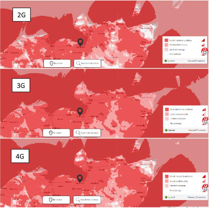
GSM network coverage is likely to vary by provider. To highlight how coverage can vary with topography and the wider environment, we illustrate this using the Vodafone coverage checker as an example (Figure 35), thought both here, and at subsequent sites, other providers should be consulted and signal strength should be confirmed as part of site visits. Patterns in coverage are relatively consistent between the 2G, 3G and 4G networks, with a noticeable drop around St Abb’s Head, particularly for 3G coverage (Figure 35), likely reflective of overall topography. Consequently, a base station may be the most effective means for data retrieval.

Forth Islands
Existing data
Gannet
Collection of movement data from gannets on the Bass Rock (grid ref NT602873), within the Forth Islands SPA, has been underway for some time with the first data collected in 1998 using PTT tags (Hamer et al., 2007) (Table 13). Since then, substantial numbers of devices have been deployed on a regular basis on both adult and immature birds (Grecian et al., 2018; Lane et al., 2020; Wakefield et al., 2013). In recent years, pressure sensors to record bird flight heights have also been deployed (Cleasby et al., 2015b; Lane et al., 2020). An additional study was carried out in 2022 in order to investigate the impact of HPAI (Jeglinski et al., 2023). Birds have been captured using noose poles, with devices typically attached with tape to birds’ tail feathers.
| Year | Capture method | Tag type | Average tag weight (g) | Attachment method | Tracking duration (days) | Sampling schedule | Number of birds |
|---|---|---|---|---|---|---|---|
| 1998 | Noose pole | PTT | 30 | Taped to tail | 5-21 | 17 | |
| 2002 | Noose pole | PTT | 30 | Taped to tail | 5-21 | 14 | |
| 2003 | Noose pole | PTT | 30 | Taped to tail | 5-21 | 9 | |
| 2003 | Noose pole | GPS | 70 | Taped to back | 1-4 | 3 min | 13 |
| 2010 | Noose pole | GPS | 37 | Taped to tail | 2 min | 41 | |
| 2011 | Noose pole | GPS | 37 | Taped to tail | 2 min | 28 | |
| 2015-19 | Noose pole | GPS | 37 | Taped to tail | 1-2 min | 188 (adult) | |
| 2015 | Noose pole | GPS | 21 | Taped to tail | 2 min | 21 (immature) | |
| 2015-2017 | Noose pole | Pressure logger | 18 | Taped to tail | 63 (adult) | ||
| 2022 | Noose pole | GPS | 18 | Taped to tail | 18-101 | 15 min | 10 |
To investigate movements outside the breeding season, substantial numbers of geolocators have been deployed on both adult and juvenile birds (Deakin et al., 2019; Grecian et al., 2019; Kubetzki et al., 2009; Lane et al., 2021) (Table 14).
| Years deployed | Number of geolocators recovered |
|---|---|
| 2002-2004 | 34 |
| 2010-2014 | 44 |
| 2018-2019 | 73 (38 juvenile, 35 adult) |
Herring Gull
In 2019, 5 GPS tags were deployed on herring gulls on three islands within the Forth Islands SPA (Isle of May (grid ref NT656992), Craigleith (grid ref NT552869) and Fidra (NT513867)). Birds were caught using walk in traps and tags were fitted using weak-link wing harnesses (Clewley et al., 2021), providing data on bird movements for in excess of 1 year (Table 15)
| Year | Capture method | Tag type | Average tag weight (g) | Attachment method | Tracking duration (days) | Sampling schedule | Number of birds |
|---|---|---|---|---|---|---|---|
| 2019 (Isle of May) | Walk in trap | GPS | 18 | Wing-loop harness | 1+ Year | 30-60 min | 2 |
| 2019 (Craigleith) | Walk in trap | GPS | 18 | Wing-loop harness | 1+ Year | 30-60 min | 1 |
| 2019 (Fidra) | Walk in trap | GPS | 18 | Wing-loop harness | 1+ Year | 30-60 min | 2 |
Kittiwake
GPS tracking on the Isle of May National Nature Reserve has been carried out since 2010. Breeding adults were captured at the nest with a noose at the end of an extendable pole, during either incubation or chick rearing. GPS devices were attached to back or tail feathers using waterproof Tesa tape or to back feathers using superglue, depending on the tag type and weight. From 2010 to 2014, archival tags were used therefore tagged individuals were recaptured for device retrieval. From 2018 onwards, remote-download tags were used, with data downloaded to base stations when the tagged birds were at the colony. The UvA-BiTS tags used in 2020 and 2021 had an accelerometer and altimeter added to the GPS unit, allowing a more detailed investigation of behaviours at sea and flight heights. Details of the tagging protocol used on the Isle of May are presented in Table 16. In 2022, no tracking work was undertaken due to the suspension of seabird catching and handling activities in Scotland, as part of measures to limit the spread of avian influenza.
The data collection in 2010 and 2018-21 formed part of the pre-construction monitoring for offshore wind farms in the Forth/Tay region and the resulting data are not currently freely available. The data collection in 2012-14 was part of two collaborative projects - FAME (Future of the Atlantic Marine Environment) and STAR (Seabird Tracking and Research) led by the RSPB. The data from these projects can be accessed from BirdLife International’s Seabird Tracking Database.
| Year | Capture method | Tag type | Average tag weight (g) | Attachment method | Tracking duration (days) | Sampling schedule | Number of birds |
|---|---|---|---|---|---|---|---|
| 2010 | Noose pole | IgotU/GiPSy | 15.0/11.5 | Taped to back feathers | 0.7 – 2.8 | 1 min/1 min on 5 min off | 27/9 |
| 2012 | Noose pole | IgotU | 14.2 | Taped to back feathers | 1.0 – 2.4 | 1 min 40 sec | 17 |
| 2013 | Noose pole | IgotU | 16.4 | Taped to back feathers | 0.8 – 3.0 | 1 min 40 sec | 22 |
| 2014 | Noose pole | IgotU | 15.3 | Taped to back feathers | 1.0 – 2.4 | 1 min 40 sec | 11 |
| 2018 | Noose pole | Pathtrack | 4.1 | Taped to back feathers | 1.8 – 4.6 | 5 min | 16 |
| 2019 | Noose pole | Pathtrack | 4.1 | Taped to tail feathers | 0.9 – 9.9 | 5 min/10 min | 25 |
| 2020 | Noose pole | UvA-BiTS | 9.0 | Glued to back feathers | 5.4 – 36.8 | variable | 23 |
| 2021 | Noose pole | Pathtrack/UvA-BiTS | 4.0/9.0 | Taped to tail feathers/ glued to back feathers | 3.4 – 26.3 | 5 min/variable | 37/13 |
To investigate movements outside the breeding season, substantial numbers of geolocators have been deployed on kittiwakes as part of the Seatrack project (Table 17).
| Years deployed | Number of geolocators recovered |
|---|---|
| 2007-2021 | 102 |
http://seatrack.seapop.no/map/?species=rissa_tridactyla&?colony=isle%20of%20may
Guillemot
The guillemot is another key species included in the GPS tracking studies on the Isle of May and in the FAME and STAR projects. On the Isle of May, the species has been tagged since 2010. Chick-rearing adults were captured at the nest site with a noose at the end of an extendable pole. GPS tags were attached to back feathers using waterproof Tesa tape. As with kittiwakes, from 2010 to 2014 archival tags were used and individuals were recaptured to retrieve the devices. From 2018 onwards, remote-download tags were used, with data downloaded onto base stations located at the colony. The tags used in 2020 and 2021 had a time-depth recorder (TDR) integrated with the GPS unit, adding functionality useful for quantifying foraging behaviour. Details of the tagging protocol used on the Isle of May are presented in Table 18. As with kittiwakes, no tracking work was undertaken in 2022 due to the wider suspension of catching and handling seabirds as part of measures to limit the spread of avian influenza.
The data collection in 2010 and 2018-21 formed part of the pre-construction monitoring for offshore wind farms in the Forth/Tay region and the resulting data are not currently freely available. The data collected in 2012-14 as part of the FAME and STAR projects are available in BirdLife International’s Seabird Tracking Database.
| Year | Capture method | Tag type | Average tag weight (g) | Attachment method | Tracking duration (days) | Sampling schedule | Number of birds |
|---|---|---|---|---|---|---|---|
| 2010 | Noose pole | IgotU | 15.0 | Taped to back feathers | 0.9 - 2.8 | 1 min | 33 |
| 2012 | Noose pole | IgotU | 17.1 | Taped to back feathers | 0.6 – 3.9 | 1 min 40 sec | 20 |
| 2013 | Noose pole | IgotU | 17.8 | Taped to back feathers | 1.2 – 3.7 | 1 min 40 sec | 20 |
| 2014 | Noose pole | IgotU | 17.5 | Taped to back feathers | 1.9 – 2.9 | 1 min 40 sec | 8 |
| 2018 | Noose pole | Pathtrack | 11.0 | Taped to back feathers | 0.5 – 10.0 | 5 min | 24 |
| 2019 | Noose pole | Pathtrack | 11.0 | Taped to back feathers | 0.5 – 6.7 | 5 min | 24 |
| 2020 | Noose pole | Pathtrack +TDR | 16.5 | Taped to back feathers | 0.3 – 11.4 | 5 min | 25 |
| 2021 | Noose pole | Pathtrack +TDR | 16.5 | Taped to back feathers | 0.8 – 10.1 | 5 min | 23 |
To investigate movements outside the breeding season, substantial numbers of geolocators have been deployed on guillemots as part of Seatrack and other (Buckingham et al., 2021; Harris et al., 2015) projects (Table 19).
| Years deployed | Number of geolocators recovered |
|---|---|
| 2011-2014 | 70 |
| 2013-20211 | 68 |
| 2017-2020 | 42 |
1http://seatrack.seapop.no/map/?species=uria_aalge&?colony=isle%20of%20may
Razorbill
The razorbill is another species included in the GPS tracking studies on the Isle of May and in the FAME and STAR projects. On the Isle of May, the species has been tagged since 2010 and the same capture and tag attachment methods used as for guillemots. From 2010 to 2014, archival tags were used and the tagged individuals were recaptured to retrieve the devices. From 2018 onwards, remote-download tags were used, with data downloaded onto base stations located at the colony. In 2020 and 2021, the tags had a time-depth recorder (TDR) integrated with the GPS unit, adding functionality required in order to quantify foraging behaviour. Details of the tagging protocol used on the Isle of May are shown in Table 20. As with the other species on the Isle of May, no tracking work was undertaken in 2022 due to measures to limit the spread of avian influenza in Scottish seabird colonies.
The data collection in 2010 and 2018-21 formed part of the pre-construction monitoring for offshore wind farms in the Forth/Tay region and the resulting data are not currently freely available. The data collected in 2012-14 as part of the FAME and STAR projects are available in BirdLife International’s Seabird Tracking Database.
| Year | Capture method | Tag type | Average tag weight (g) | Attachment method | Tracking duration (days) | Sampling schedule | Number of birds |
|---|---|---|---|---|---|---|---|
| 2010 | Noose pole | IgotU | 15.0 | Taped to back feathers | 0.4 - 2.8 | 1 min | 18 |
| 2012 | Noose pole | IgotU | 17.7 | Taped to back feathers | 0.6 – 3.0 | 1 min 40 sec | 15 |
| 2013 | Noose pole | IgotU | 17.7 | Taped to back feathers | 2.5 – 5.0 | 1 min 40 sec | 7 |
| 2014 | Noose pole | IgotU | 17.7 | Taped to back feathers | 2.4 – 2.9 | 1 min 40 sec | 5 |
| 2018 | Noose pole | Pathtrack | 8.2 | Taped to back feathers | 0.3 – 9.7 | 10 min | 14 |
| 2019 | Noose pole | Pathtrack | 8.2 | Taped to back feathers | 4.6 – 9.0 | 10 min | 14 |
| 2020 | Noose pole | Pathtrack +TDR | 13.0 | Taped to back feathers | 0.3 – 12.9 | 5 min | 15 |
| 2021 | Noose pole | Pathtrack +TDR | 12.8 | Taped to back feathers | 2.1 – 10.2 | 5 min | 11 |
To investigate movements outside the breeding season, substantial numbers of geolocators have been deployed on razorbills on the Isle of May (Buckingham et al., 2021; St. John Glew et al., 2019) (Table 21).
| Years deployed | Number of geolocators recovered |
|---|---|
| 2008 | 17 |
| 2015 | 9 |
| 2017-2020 | 22 |
Work planned for 2023
In addition to ongoing tagging projects on kittiwake, guillemot and razorbill on the Isle of May led by UKCEH, RSPB have plans to deploy up to 20 GPS tags on gannets at Bass Rock, within the Forth Islands SPA, during the 2023 breeding season, subject to any restrictions imposed due to the impacts of HPAI.
Consideration for future work
In addition to the Isle of May and the Bass Rock, a number of other locations within the Forth Islands offer the potential for tagging studies including, Craigleith (guillemot, razorbill, kittiwake, herring gull), Fidra (guillemot, razorbill, kittiwake, herring gull) and Inchmickery (grid ref NT206805: herring gull). Capture at The Lamb (grid ref NT535865) is not considered appropriate because of the likelihood of significant disturbance, particular to breeding cormorants. There are long-term ringing programmes on these islands undertaken by the Lothian Ringing Group, and liaison with this group is critical before any GPS tracking is undertaken. In all cases personnel should be aware of any other sensitive species that may be disturbed due to tagging activities. Permission will also need to be sought from landowners, which can be facilitated through the ringing group.
Access to these islands is by boat from North Berwick or Granton, the former limited by tidal conditions. These islands comprise sheer cliffs, firm sloping shorelines and grassy slopes. The substrate is mostly firm, grippy rock in areas away from grassy slopes. The terrain is complex with numerous small ledges, low cliffs, cracks and crevices. Birds could be targeted for tracking that avoids high cliffs. Clear line of sight to nests is sometimes possible but not for all options for tracking (e.g. those facing out to sea).
At each site there is the potential to catch good numbers of herring gull and kittiwake and more modest numbers of guillemot and razorbill, using standard approaches such as noose poles or walk in traps (for gulls), without the need for rope access. Once captured there is potential to fit tags away from the main colony. Whilst recapture of tagged birds is possible, the additional disturbance to the breeding colony makes this undesirable, and remote download systems are preferable. GSM Network coverage on the islands is generally good, making GPS GSM tags an option for these sites (Figure 36). However, 4G tags should be used as 3G coverage is very patchy. Confirmation of network coverage, from a variety of different providers, should also be sought prior to ordering tags. Alternatively, base stations would also offer a reliable option, and given the need for boat access to the islands, may also be located securely on the island.

Fowlsheugh
Existing data
Kittiwake
In addition to previous tracking at Fowlsheugh, as part of the FAME and STAR projects, more recent tracking work has been carried out there funded by the Offshore Wind Industry (Table 22). Whilst data from the FAME and STAR projects are available in BirdLife International’s Seabird Tracking Database, the data collected on behalf of industry are not available at present.
| Year | Capture method | Tag type | Average tag weight (g) | Attachment method | Tracking duration (days) | Sampling schedule | Number of birds |
|---|---|---|---|---|---|---|---|
| 2012 | Noose pole | IgotU | 16.4 | Taped to back feathers | 0.8 – 3.0 | 1 min 40 sec | 15 |
| 2021 | Noose pole | Pathtrack/UvA-BiTS | 4.0/9.0 | Taped to tail feathers/ glued to back feathers | 0.4 – 39.3 | 5 min/variable | 26/14 |
Guillemot
Guillemots were previously tracked at Fowlsheugh as part of the FAME and STAR projects (Table 23). These data are available in BirdLife International’s Seabird Tracking Database.
| Year | Capture method | Tag type | Average tag weight (g) | Attachment method | Tracking duration (days) | Sampling schedule | Number of birds |
|---|---|---|---|---|---|---|---|
| 2012 | Noose pole | IgotU | 17.1 | Taped to back feathers | 0.6 – 3.9 | 1 min 40 sec | 10 |
Work planned for 2023
RSPB have plans to deploy up to 50 GPS tags on kittiwakes within the Fowlsheugh SPA during the 2023 breeding season, subject to any restrictions imposed due to the impact of HPAI.
Consideration for future work
Fowlsheugh is an RSPB reserve with good access and car parking. Permission should be sought from RSPB, as landowners, in order to carry out tagging studies at this site. Much of the site is characterized by sheer cliffs. Away from the existing tagging sites, the cliffs are less well populated with seabirds, which are often concentrated on central parts of the cliff and difficult to access from the top or bottom. As birds are often densely packed on narrow ledges, there is a significant risk of disturbance, meaning care would need to be taken. However, there are a number of sites that may be accessible from above using rope access, or below using boat access where both guillemots and kittiwakes are accessible. Public access, and particularly disturbance by photographers, may be an issue. There may be significant numbers of accessible razorbills close to the top of the cliffs. However, recapturing these birds to retrieve tags is likely to be challenging. Consequently, this site may be suitable for deploying remote download GPS on razorbills, but less suitable for archival tags like geolocators. Additional visits to confirm this during the 2023 breeding season, when birds will be present, would be valuable.
GSM network coverage at this site is good (Figure 37), meaning GPS GSM tags may be an option at this site. However, coverage should be confirmed prior to ordering any tags. This is particularly important given the potential for the topography of the site to interfere with the GSM signal.

Buchan Ness to Collieston Coast
Existing data
Kittiwake
GPS tagging of kittiwake took place in two locations, Whinnyfold (grid ref NK077477) and Bullers of Buchan (NK109380), within the Buchan Ness to Collieston Coast SPA as part of the FAME and STAR projects in 2012 (Table 24). Birds were captured using a noose pole and tags were deployed by taping them to back feathers. Subsequently, in 2021, additional tagging work took place at Whinnyfold led by BTO on behalf of Vattenfall, with tags deployed using glue, allowing for longer term deployments. To test the potential for longer-term tag deployment, an additional 6 PTT tags were deployed in 2021, three using a thoracic harness and three using a leg-loop harness (Clewley et al., 2022). Following evidence of deleterious device effects, these were removed after 10 days.
| Year | Capture method | Tag type | Average tag weight (g) | Attachment method | Tracking duration (days) | Sampling schedule | Number of birds |
|---|---|---|---|---|---|---|---|
| 2012 (Bullers of Buchan) | Noose pole | IgotU | 14.2 | Taped to back feathers | 1 min 40 sec | 5 | |
| 2012 (Whinnyfold) | Noose pole | IgotU | 14.2 | Taped to back feathers | 1 min 40 sec | 20 | |
| 2021 (Whinnyfold) | Noose pole | GPS | 10.0 | Glued to back feathers | 18-47 | 10 sec – 10 min | 20 |
| 2021 (Whinnyfold) | Noose pole | PTT | 7.9 | Thoracic harness | 10 | 3 | |
| 2021 (Whinnyfold) | Noose pole | PTT | 6.8 | Leg-loop harness | 10 | 3 |
Guillemot
GPS tagging of guillemots took place in two locations, Whinnyfold and Bullers of Buchan, within the Buchan Ness to Collieston Coast SPA as part of the FAME and STAR projects in 2012 (Table 25). Birds were captured using a noose pole and tags were deployed by taping them to back feathers.
| Year | Capture method | Tag type | Average tag weight (g) | Attachment method | Tracking duration (days) | Sampling schedule | Number of birds |
|---|---|---|---|---|---|---|---|
| 2012 (Bullers of Buchan) | Noose pole | IgotU | 14.2 | Taped to back feathers | 1 min 40 sec | 2 | |
| 2012 (Whinnyfold) | Noose pole | IgotU | 14.2 | Taped to back feathers | 1 min 40 sec | 5 |
As part of a recent project to investigate wintering movements of guillemots (Buckingham et al., 2021), geolocators have been deployed on birds at Whinnyfold (Table 26).
| Years deployed | Number of geolocators recovered |
|---|---|
| 2017-2020 | 55 |
Razorbill
As part of a recent project to investigate wintering movements of razorbills (Buckingham et al., 2021), geolocators have been deployed on birds at Whinnyfold (Table 27).
| Years deployed | Number of geolocators recovered |
|---|---|
| 2017-2020 | 10 |
Work planned for 2023
Subject to any restrictions imposed as a result of the impacts of HPAI, BTO have plans to deploy 25 GPS tags and 30 geolocators on kittiwake, 25 integrated GPS and TDR tags and 30 integrated geolocators and TDRs on guillemots, 25 integrated GPS and TDR tags and 30 integrated geolocators and TDRs on razorbills at Whinnyfold, within the Buchan Ness to Collieston Coast SPA, during the 2023 breeding season. The BTO also intend to carry out a further harness trial, using a modified leg-loop harness.
In addition, BTO intend to assess the potential to deploy tags at other locations within the SPA, with a view to identifying additional sites for tagging studies in future breeding seasons.
Consideration for future work
There are two key sites for deploying tags within the Buchan Ness to Collieston Coast SPA, Bullers of Buchan and Whinnyfold.
Bullers of Buchan is characterized by granite cliffs, with some grassy gullies which allow access to the shore. Kittiwakes, guillemots and razorbills are all present, but birds are only really accessible from below. Access may be challenging as it involves scrambling over often wet and slippery rocks and poor line of sighe may make the use of remote download base stations challenging. Furthermore, access issues may make revisiting the colony to retrieve tags challenging. However, it would be worth revisiting this site during the 2023 breeding season to further assess potential options whilst birds are present.
At Whinnyfold there are a number of good options for catching kittiwakes, guillemots and razorbills. Substantial numbers of birds could be caught, and the availability of different sites means that it would be straightforward to minimise disturbance at any individual site. Potential catching options could be expanded further with the use of a boat, or through ensuring suitably trained personnel were able to offer rope access to help with the capture of birds. There is also a small colony of herring gulls that nest on a flat rock which is accessible at low tide, or with the use of a boat, which would be accessible for deploying GPS tags. There is good line of sight at this site, making the use of a remote download base station relatively straightforward. Whilst retrieval of archival tags is possible, the ease of this varies across the site.
There may be additional locations within the SPA where there are accessible birds, notably around Sands of Forvie National Nature Reserve (grid ref NK011250). It would be valuable to visit these sites, in addition to Whinnyfold and Bullers of Buchan, during the 2023 breeding season to assess this.
GSM Network coverage within the SPA is patchy, particularly towards the southern end (Figure 38). Consequently, given good potential options in relation to line of sight, remote download base stations are likely to be most appropriate within this SPA.

Troup, Pennan and Lion’s Heads
Existing data
None of the focal species have previously been tracked within the Troup, Pennan and Lion’s Heads SPA.
Work planned for 2023
At present, there is no additional tagging work planned for Troup, Pennan and Lion’s Heads SPA during the 2023 breeding season. However, BTO intend to undertake visits during the breeding season to assess the potential for tagging studies in future years.
Consideration for future work
Previous seabird ringing took place here in the 1970’s and 1980’s when large concentrations of auks and kittiwakes were accessible. However, the expansion of gannets appears to have led to the exclusion of auks from their previous nest sites. The site itself is characterized by very high cliffs, sheer in places, with evidence of erosion by gannets, likely resulting in large numbers of loose rocks. Most of the cliff faces appear to be inaccessible from above and below. However, there may be a small colony (~25 nests) of kittiwakes that is accessible at the bottom of the cliffs down a steep, grassy slope (Figure 39). During a visit in November 2022 a large number of dead gannets were visible above this site, suggesting there may be significant HPAI concerns. None of the gannets’ nest sites appear to be accessible. Viewing the site from the sea during the breeding season would be valuable to confirm this. Troup Head is an RSPB reserve, and permission must be sought from RSPB prior to any tagging activity that takes place at this site.

There may be reasonable GSM coverage at the site (Figure 40), so GPS GSM tags may be an option for data retrieval at this site, though this would require careful consideration across a range of different providers. Alternatively a base station at the top of the cliffs may be suitable.

East Caithness Cliffs
Existing data
Herring gull
As part of work carried out in relation the Moray Firth Offshore Wind Farms, seven herring gulls were tracked within the East Caithness Cliffs SPA in 2014 (table 28).
| Year | Capture method | Tag type | Average tag weight (g) | Attachment method | Tracking duration (days) | Sampling schedule | Number of birds |
|---|---|---|---|---|---|---|---|
| 2014 | 7 |
Great black-backed gull
As part of work carried out in relation the Moray Firth Offshore Wind Farms, 11 great black-backed gulls were tracked within the East Caithness Cliffs SPA in 2014 (table 29).
| Year | Capture method | Tag type | Average tag weight (g) | Attachment method | Tracking duration (days) | Sampling schedule | Number of birds |
|---|---|---|---|---|---|---|---|
| 2014 | 11 |
Guillemot
As part of a recent project to investigate wintering movements of guillemots (Buckingham et al., 2021), geolocators have been deployed on birds within the East Caithness Cliffs SPA (Table 29).
| Years deployed | Number of geolocators recovered |
|---|---|
| 2017-2020 | 56 |
Razorbill
As part of a recent project to investigate wintering movements of razorbills (Buckingham et al., 2021), geolocators have been deployed on birds within the East Caithness Cliffs SPA (Table 30).
| Years deployed | Number of geolocators recovered |
|---|---|
| 2017-2020 | 22 |
Work planned for 2023
At present, there is no additional tagging work planned for East Caithness Cliffs SPA during the 2023 breeding season. However, BTO intend to undertake visits during the breeding season to assess the potential for tagging studies in future years.
Consideration for future work
A key species for East Caithness Cliffs is great black-backed gull. However, numbers appear to have declined substantially in recent years, and very few accessible nests remain. Indeed, the number of great black-backed gulls colour-ringed in Caithness as a whole declined from 26 in 2016 to just 2 in 2019. Birds are increasingly concentrated on inaccessible, offshore stacks, meaning deploying any tags is likely to be very difficult, if not impossible.
There are three key sites for the remaining species (kittiwake, guillemot and razorbill) within the East Caithness Cliffs SPA – Berriedale Castle (grid ref ND158282), Ceann Ousdale (grid ref ND075183) and Badbea (grid ref NH026910).
Ceann Ousdale (Figure 41) offers the greatest potential for catching kittiwakes within the SPA, with around 60 readily accessible pairs, though this would need to be confirmed in the 2023 breeding season following the HPAI outbreak. However, the catching site would only be accessible by boat at low tide. Birds could be caught using noose poles, and a two-section ladder would improve access to nests. GSM Network coverage is poor, and the challenges of accessing the site make the use of archival tags undesirable. However, there are a number of potential options for deploying base stations in locations that would not require boat access.

Berriedale Castle (Figure 42) offers another potential site for tagging kittiwakes. However, this site has undergone substantial declines in recent years, and the presence of corpses in Autumn 2022 suggests that it may have been badly impacted by HPAI. The birds nest at the top of a steep, grassy slope. Consequently, rope access would be essential for catching birds. Again, GSM Network coverage is poor, though retrieving archival tags, whilst still challenging, may be more straightforward than is the case at Ceann Ousdale. However, line of sight is good, meaning a remote download base station would be suitable.

The final site in East Caithness SPA is at Badbea, where there is a mixed colony of kittiwakes, guillemots and razorbills (Figure 43). There are good numbers of both guillemots and razorbills that are likely to be readily accessible, though given the steep slope, rope access would be essential. There are fewer accessible kittiwakes at this site, and these should be accessed from below to avoid disturbing other birds. Again, GSM Network coverage is poor, making remote download base stations desirable at this site.
NatureScot are planning surveys of the East Caithness Cliffs colonies in June 2023 as part of the programme of monitoring being co-ordinated by RSPB to investigate the impacts of HPAI. Alongside these surveys, it would be advantageous to revisit all three of these sites during the 2023 breeding season in order to more clearly assess the number of accessible birds, and to better assess the impacts of HPAI on the breeding populations.

As previously highlighted, GSM network coverage within the East Caithness Cliffs SPA is very patchy (Figure 44). Consequently, remote download base stations, rather than GPS GSM tags should be used within this SPA.

North Caithness Cliffs
Existing data
No previous tracking of the focal species has taken place within the North Caithness Cliffs SPA.
Work planned for 2023
At present, there is no additional tagging work planned for North Caithness Cliffs SPA during the 2023 breeding season. However, BTO intend to undertake visits during the breeding season to assess the potential for tagging studies in future years.
Consideration for future work
On the mainland, the most accessible site for kittiwake is likely to be Drumhollistan (grid ref NC879647). However, due to the popularity of the area with birdwatchers and hikers, parking close to the site is extremely limited and, access is likely to involve a long walk over difficult terrain. Catching birds will require rope access and, as GSM Network Coverage is poor, a remote download base station is likely to be essential for data retrieval. Offshore, the island of Stroma may offer opportunities to tag some of the focal species. However, to assess this properly, it would be essential to visit the site during the 2023 breeding season.
As previously highlighted, GSM Network coverage within this SPA is very patchy (Figure 45), meaning the remote download base stations are likely to be required for any data retrieval.
Copinsay
Existing data
Kittiwake
GPS tagging of kittiwake took place on Copinsay as part of the FAME and STAR projects between 2010 and 2014 (Table 31). Birds were captured using a noose pole and tags were deployed by taping them to back feathers.
| Year | Capture method | Tag type | Average tag weight (g) | Attachment method | Tracking duration (days) | Sampling schedule | Number of birds |
|---|---|---|---|---|---|---|---|
| 2010 | Noose pole | IgotU | 15 | Taped to back feathers | 1-2 | 1 min 40 sec | 11 |
| 2011 | Noose pole | IgotU | 15 | Taped to back feathers | 1-2 | 1 min 40 sec | 7 |
| 2012 | Noose pole | IgotU | 14.2 | Taped to back feathers | 2-3 | 1 min 40 sec | 8 |
| 2014 | Noose pole | IgotU | 15.3 | Taped to back feathers | 2-3 | 1 min 40 sec | 3 |
Guillemot
GPS tagging of guillemot took place on Copinsay as part of the FAME and STAR projects in 2012 and 2014 (Table 32). Birds were captured using a noose pole and tags were deployed by taping them to back feathers.
| Year | Capture method | Tag type | Average tag weight (g) | Attachment method | Tracking duration (days) | Sampling schedule | Number of birds |
|---|---|---|---|---|---|---|---|
| 2012 | Noose pole | IgotU | 17.7 | Taped to back feathers | 3-4 | 1 min 40 sec | 4 |
| 2014 | Noose pole | IgotU | 17.7 | Taped to back feathers | 2-3 | 1 min 40 sec | 5 |
Razorbill
GPS tagging of razorbill took place on Copinsay as part of the FAME and STAR projects between 2010 and 2014 (Table 33). Birds were captured using a noose pole and tags were deployed by taping them to back feathers.
| Year | Capture method | Tag type | Average tag weight (g) | Attachment method | Tracking duration (days) | Sampling schedule | Number of birds |
|---|---|---|---|---|---|---|---|
| 2010 | Noose pole | IgotU | 15 | Taped to back feathers | 1-2 | 1 min 40 sec | 1 |
| 2011 | Noose pole | IgotU | 17.7 | Taped to back feathers | 1-2 | 1 min 40 sec | 1 |
| 2012 | Noose pole | IgotU | 17.7 | Taped to back feathers | 2-3 | 1 min 40 sec | 6 |
| 2013 | Noose pole | IgotU | 17.7 | Taped to back feathers | 1-2 | 1 min 40 sec | 3 |
| 2014 | Noose pole | IgotU | 17.7 | Taped to back feathers | 2-3 | 1 min 40 sec | 3 |
Work planned for 2023
At present, there is no additional tagging work planned for Copinsay SPA during the 2023 breeding season. However, there is an intention to carry out a full census of all seabirds nesting on Copinsay in the 2023 breeding season.
Consideration for future work
Copinsay is only accessible by boat and RSPB, who own the site, have a reliable contact who can provide this facility. Whilst there are no facilities on the site, it is possible to camp.
There are good options for tagging kittiwake, great black-backed gull and razorbill on Copinsay. However, both kittiwake and great black-backed gull appear to have been impacted by HPAI. The cliff nesting kittiwakes should be easily accessible for tagging purposes, with a good number of nests also visible from a distance for the purposes of monitoring any potential device effects. However, the population has declined substantially since the previous tagging work carried out as part of the FAME project, from about 7000 pairs to around 1000 pairs in recent years.
There are 16 apparently occupied territories for great black-backed gull on the flat, maritime grassland of Copinsay, with additional birds present on small islands to the west of Copinsay which accessible at low tide. Some of these birds are catchable, and should be visible at a distance for the purposes of monitoring device effects.
Razorbills nest in the boulder fields on the island and would be very accessible for the purposes of tagging. In contrast, the guillemots nest on cliffs in areas which whilst accessible by boat, would prove challenging to monitor for any device effects.
GSM Network coverage on Copinsay is poor (Figure 46), meaning that a remote download base station is likely to be required for data retrieval.

Fair Isle
Existing data
Kittiwake
GPS tagging of kittiwake took place on Fair Isle as part of the FAME and STAR projects between 2010 and 2014 (Table 34). Birds were captured using a noose pole and tags were deployed by taping them to back feathers.
| Year | Capture method | Tag type | Average tag weight (g) | Attachment method | Tracking duration (days) | Sampling schedule | Number of birds |
|---|---|---|---|---|---|---|---|
| 2010 | Noose pole | IgotU | 15 | Taped to back feathers | 1-2 | 1 min 40 sec | 2 |
| 2011 | Noose pole | IgotU | 15 | Taped to back feathers | 1-2 | 1 min 40 sec | 4 |
| 2012 | Noose pole | IgotU | 14.2 | Taped to back feathers | 1-2 | 1 min 40 sec | 5 |
| 2014 | Noose pole | IgotU | 15.3 | Taped to back feathers | 1-2 | 1 min 40 sec | 2 |
Geolocators were deployed on kittiwakes on Fair Isle as part of a project to investigate the over winter distribution of birds from multiple colonies (Bogdanova et al., 2017; Frederiksen et al., 2012) (Table 35).
| Years deployed | Number of geolocators recovered |
|---|---|
| 2017-2020 | 15 |
Guillemot
GPS tagging of guillemots took place on Fair Isle as part of the FAME and STAR projects between 2010 and 2014 (Table 36). Birds were captured using a noose pole and tags were deployed by taping them to back feathers.
| Year | Capture method | Tag type | Average tag weight (g) | Attachment method | Tracking duration (days) | Sampling schedule | Number of birds |
|---|---|---|---|---|---|---|---|
| 2011 | Noose pole | IgotU | 17.7 | Taped to back feathers | 3-4 | 1 min 40 sec | 3 |
| 2012 | Noose pole | IgotU | 17.7 | Taped to back feathers | 2-3 | 1 min 40 sec | 7 |
| 2013 | Noose pole | IgotU | 17.7 | Taped to back feathers | 5 | 1 min 40 sec | 1 |
| 2014 | Noose pole | IgotU | 17.7 | Taped to back feathers | 3-4 | 1 min 40 sec | 5 |
| 2015 | Noose pole | IgotU | 17.7 | Taped to back feathers | 3-4 | 1 min 40 sec | 2 |
As part of a recent project to investigate wintering movements of guillemots (Buckingham et al., 2021), geolocators have been deployed on birds within the Fair Isle SPA (Table 37).
| Years deployed | Number of geolocators recovered |
|---|---|
| 2017-2020 | 15 |
Razorbill
GPS tagging of razorbills took place on Fair Isle as part of the FAME and STAR projects between 2010 and 2014 (Table 38). Birds were captured using a noose pole and tags were deployed by taping them to back feathers.
| Year | Capture method | Tag type | Average tag weight (g) | Attachment method | Tracking duration (days) | Sampling schedule | Number of birds |
|---|---|---|---|---|---|---|---|
| 2011 | Noose pole | IgotU | 17.7 | Taped to back feathers | 2-3 | 1 min 40 sec | 22 |
| 2012 | Noose pole | IgotU | 17.7 | Taped to back feathers | 2-3 | 1 min 40 sec | 23 |
| 2013 | Noose pole | IgotU | 17.7 | Taped to back feathers | 3-4 | 1 min 40 sec | 8 |
| 2014 | Noose pole | IgotU | 17.7 | Taped to back feathers | 3-4 | 1 min 40 sec | 17 |
| 2015 | Noose pole | IgotU | 17.7 | Taped to back feathers | 3-4 | 1 min 40 sec | 7 |
As part of a recent project to investigate wintering movements of razorbills (Buckingham et al., 2021), geolocators have been deployed on birds within the Fair Isle SPA (Table 39).
| Years deployed | Number of geolocators recovered |
|---|---|
| 2017-2020 | 11 |
Work planned for 2023
At present, there is no tagging work planned on the focal species on Fair Isle during the 2023 breeding season.
Consideration for future work
The landowner for Fair Isle is the National Trust for Scotland, who would need to be approached in relation to permission for any proposed tagging work. There is a boat available to help with access to some of the more sheltered bays and offshore islands. Reconstruction of the bird observatory, which may be available to provide accommodation for field staff, is underway.
Whilst both gannets and great skuas on Fair Isle have been affected by HPAI, none of the other seabird species showed obvious signs of the disease during the 2022 breeding season. Gannet ringing on Fair Isle has stopped due to health and safety concerns, meaning tagging projects are not feasible on this species. As with Copinsay, kittiwake populations have undergone substantial declines with roughly 1,400 birds present in 2010, down to 450 birds in 2021. Furthermore, the majority of these birds are present in study plots and it is likely that the wardens and National Trust for Scotland would be extremely reluctant to permit any tagging work on these birds. Consequently, as with gannets, tagging of kittiwakes on Fair Isle is unlikely to be feasible.
In 2021, there were approximately 18,000 guillemots and 2,000 razorbills nesting in a mixture of cliffs and boulder beaches. The East coast of Fair Isle is more reliably accessible than the West coast, with boulder beach colonies of mixed auks at the Ramnigeos, and smaller razorbill colonies at Mavers Geo and Busta Geo (Figure 47). These would all be visible from cliff tops using a scope for the purposes of monitoring potential device effects.

GSM network coverage is patchy, particularly around the coasts (Figure 48), in areas where the majority of birds are located. Consequently, a remote download base station is likely to be required for data retrieval.

Contact
Email: ScotMER@gov.scot
There is a problem
Thanks for your feedback