
Passive acoustic monitoring as a tool for offshore wind farm biodiversity assessments: a pilot study
Pilot study on the use of underwater passive acoustic recordings to monitor changes in biodiversity on the East Coast of Scotland. The focus of this study was to assess fish’s and crustacean’s active and passive sounds.
8. Supplementary materials
S1 Sound Pressure Levels
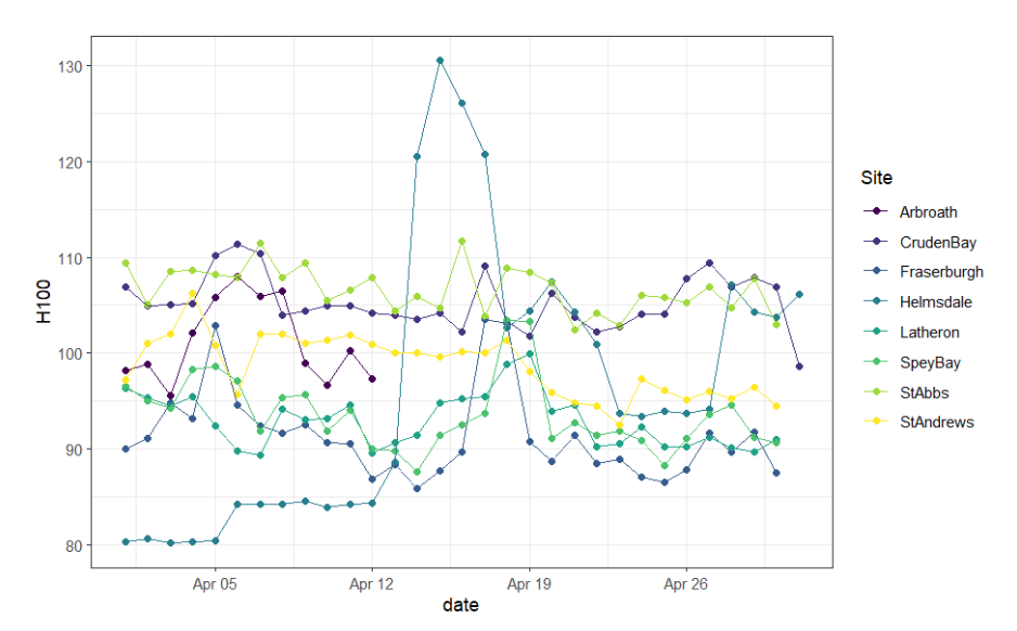
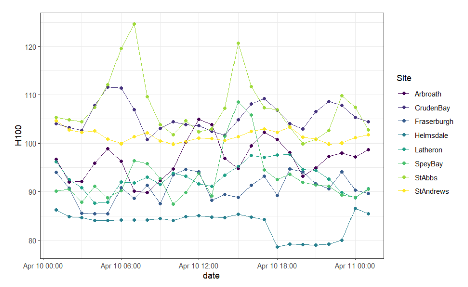
Sound Pressure Levels were calculated using PAMGuide in MATLAB (Merchant et al. 2015). Third-Octave Level (TOL) SPLs were calculated at 60-second resolution from 1-2000Hz, in order to characterise both benthic biodiversity and noise pollution from shipping noise (Merchant et al. 2016). TOL data was calculated based on the raw sound files. While some shipping activity is present at the St Abbs location (SPL peaks at 130 dB and 120 dB), the 10th of April is mostly absent of ship noise.
S2 Biological and environmental data sets
Overview of the contextual and environmental data layers, which were downloaded from open-source websites.
|
Layer |
Source |
|---|---|
|
Depth (m) |
|
|
Habitat map (EUNIS classification) |
|
|
Temperature, Currents, Light, DOC, Phytoplankton, Primary Productivity, Chlorophyll |
|
|
Faunal cluster class, benthic biodiversity |
|
|
NBN atlas |
|
|
Spawning and nursery ground layers |
Spawning and Nursery Grounds Layers for Selected Fish in UK Waters in 2010 - Cefas Developing essential fish habitat maps - Scottish Government 2023 |
S3 Start time and length of the recordings
The timings which are highlighted in bold indicate the files that had the largest amount of noise pollution and were therefore drastically reduced in file length.
|
Site |
Phase |
Start time |
Cleaned file length (mm:ss) |
|---|---|---|---|
|
Arbroath |
Midnight |
01:20:00 |
04:12 |
|
Arbroath |
Sunrise |
06:20:00 |
03:16 |
|
Arbroath |
Midday |
13:20:00 |
02:43 |
|
Arbroath |
Sunset |
19:50:00 |
04:02 |
|
CrudenBay |
Midnight |
01:25:00 |
09:50 |
|
CrudenBay |
Sunrise |
06:25:00 |
09:56 |
|
CrudenBay |
Midday |
12:55:00 |
09:46 |
|
CrudenBay |
Sunset |
19:55:00 |
09:40 |
|
Fraserburgh |
Midnight |
01:05:00 |
05:31 |
|
Fraserburgh |
Sunrise |
06:35:00 |
09:17 |
|
Fraserburgh |
Midday |
13:05:00 |
06:02 |
|
Fraserburgh |
Sunset |
20:05:00 |
09:40 |
|
Helmsdale |
Midnight |
01:25:00 |
09:59 |
|
Helmsdale |
Sunrise |
06:25:00 |
09:59 |
|
Helmsdale |
Midday |
13:25:00 |
09:59 |
|
Helmsdale |
Sunset |
19:55:00 |
09:59 |
|
Latheron |
Midnight |
01:15:00 |
06:27 |
|
Latheron |
Sunrise |
06:15:00 |
09:38 |
|
Latheron |
Midday |
13:15:00 |
04:29 |
|
Latheron |
Sunset |
19:45:00 |
06:50 |
|
SpeyBay |
Midnight |
01:15:00 |
09:58 |
|
SpeyBay |
Sunrise |
06:15:00 |
09:59 |
|
SpeyBay |
Midday |
13:15:00 |
09:40 |
|
SpeyBay |
Sunset |
19:45:00 |
10:00 |
|
StAbbs |
Midnight |
01:00:00 |
09:27 |
|
StAbbs |
Sunrise |
06:30:00 |
10:00 |
|
StAbbs |
Midday |
13:00:00 |
09:18 |
|
StAbbs |
Sunset |
20:00:00 |
09:09 |
|
StAndrews |
Midnight |
01:00:00 |
09:58 |
|
StAndrews |
Sunrise |
06:30:00 |
09:53 |
|
StAndrews |
Midday |
13:00:00 |
10:00 |
|
StAndrews |
Sunset |
20:00:00 |
09:52 |
S4 Biological variables associated with each site
|
Location |
Predicted Habitat type |
Depth (m) |
Taxa Richness |
Faunal Class |
Area Class (km2) |
No. Taxonomic Classes |
|---|---|---|---|---|---|---|
|
Spey Bay |
Coarse |
23 |
8±5 |
D2c |
136.66 |
5 |
|
Latheron |
Coarse |
26 |
24±8 |
D2a |
30.69 |
3 |
|
Fraserburgh |
Coarse |
38 |
27±8 |
D2b |
147.57 |
3 |
|
St Andrews |
Coarse |
41 |
27±8 |
D2b |
152.59 |
6 |
|
St Abbs |
Hard |
34 |
8±5 |
D2c |
17.86 |
5 |
|
Cruden Bay |
Sandy |
21 |
8±5 |
D2c |
152.72 |
5 |
|
Arbroath |
Sandy |
47 |
24±8 |
D2b |
65.13 |
5 |
|
Helmsdale |
Sandy |
48 |
24±8 |
D2b |
295.15 |
5 |
S5 Summary data for the types of sounds used to calculate phonic richness
Presented are the mean duration, frequencies and power of each sound type.
|
Row Labels |
Count of Sound Type |
Average Duration (s) |
Low frequency (Hz) |
High frequency (Hz) |
Peak frequency (Hz) |
|---|---|---|---|---|---|
|
ST1 |
143 |
0.44 |
25.56 |
572.6 |
82.28 |
|
ST2 |
49 |
0.19 |
5682.49 |
26705 |
7875 |
|
ST3 |
22 |
0.35 |
193.75 |
1037.16 |
421.88 |
|
ST4 |
53 |
0.83 |
197.53 |
2610.7 |
397.11 |
|
ST5 |
4 |
0.2 |
145.84 |
745.78 |
410.16 |
|
ST6 |
931 |
0.3 |
260.8 |
2386.31 |
547.7 |
|
ST7 |
27 |
2.58 |
1786.84 |
12053.26 |
3168.4 |
|
ST8 |
3 |
0.67 |
1996.22 |
20478.08 |
2828.13 |
|
ST9 |
1 |
0.24 |
0 |
5714.31 |
46.88 |
|
ST10 |
3 |
0.44 |
2067.21 |
5885.98 |
3015.63 |
|
ST11 |
18 |
0.23 |
856.82 |
1956.79 |
1200.52 |
|
ST12 |
5 |
0.36 |
650.29 |
1978.17 |
937.5 |
|
ST13 |
18 |
0.25 |
32.04 |
642.29 |
85.94 |
|
ST14 |
2 |
0.27 |
0 |
2373.23 |
46.88 |
|
ST15 |
2 |
0.88 |
129.27 |
1246.28 |
164.06 |
|
ST16 |
15 |
0.78 |
40.22 |
1634.3 |
115.63 |
Contact
Email: ScotMER@gov.scot