Developing a method to estimate the costs of soil erosion in high-risk Scottish catchments: final report
Report from a project which developed and used an ecosystem service framework approach to estimate the costs of soil erosion in Scotland, for five study catchments.
Appendix 1. Literature Review
Developing a method to estimate the costs of soil erosion in high-risk Scottish catchments: Literature review
Project NO: UCR/004/18 CRF CR/2015/15
Literature Review Executive Summary
Scotland’s soils provide economic, social and environmental support to the country, but inappropriate soil management threatens this finite natural resource. Soil erosion was identified as one of the main soil threats in the ‘State of Scotland’s Soil Report’ (2011). Soil loss can result in significant costs, not only to immediate users of soils, but to society as a whole.
This review has collated the evidence on current soil erosion rates; how these are modified by mitigation measures; the associated ‘on-site’ and ‘off-site’ impacts of soil erosion; and any costs associated with those impacts. The aim is to estimate the total costs of soil erosion in Scotland. Understanding the costs of soil erosion will inform policies designed to value the soil resource.
The literature review suggests that soil erosion by water is the dominant erosion process in Scotland. Notable soil erosion events are triggered by either high intensity rainfall; prolonged, low intensity rainfall; or rapid snowmelt. Land uses affected include forests and agriculture (especially bare, recently ploughed / seeded arable fields in winter cereals). Observed erosion rates in arable areas of Scotland range from 0.01 t ha-1 yr-1 to 23.0 t ha-1 yr-1, which can exceed an identified tolerable limit of 1 t ha-1 yr-1. Limitations of the current evidence base include a tendency to focus on small areas of severe soil erosion, rather than a systematic approach to monitor and assess more insidious erosion. In general, quantified rates for all forms of soil erosion in Scotland remain sparse.
Regarding the on-site impacts of soil erosion, there is very little quantification of the reductions in crop yields due to soil erosion in Scotland. Single soil erosion events rarely cause significant problems for farmers, but over time may impact on the long-term sustainability of the land and can still result in loss of ecosystem goods and services such as crop production, but also carbon sequestration and water storage. These on-site impacts of soil erosion may take a long time to take effect, especially on deeper soils or where inputs of fertilisers can mask yield declines due to soil loss.
Off-site, soil erosion contributes to increased suspended sediments and turbidity in Scottish watercourses, which can diminish water quality and damage aquatic life, including salmon spawning ground and freshwater pearl mussel beds. In general, the greater the proportion of arable cropping in a catchment (and thus soil erosion risk), the greater the increase in suspended sediment load in waterways. However, the present review has found few quantified studies of the off-site impacts of soil erosion in Scotland.
There is some evidence on the use of erosion mitigation measures in Scotland: most was related to practices on forested land. However, monetary costs (and benefits) associated with measures to combat soil erosion and sediment transport are lacking for Scotland.
The ‘on-site’ and ‘off-site’ costs of soil erosion are incurred in many different ways, affecting a diverse range of ecosystems services and benefits to people, over a range of spatial and temporal scales. This makes estimating the costs of soil erosion particularly challenging and may explain the limited quantified evidence on the costs associated with soil erosion in Scotland.
Whilst the literature review demonstrates that evidence on soil erosion rates, impacts, mitigation and costs in Scotland tends to be anecdotal rather than quantitative, there are proven approaches that can estimate these parameters in a logical and justified manner. These estimates may have some uncertainty, given the paucity of data. Even so, this information can then be used to calculate an estimated mean soil erosion rate for different combinations of land use/ soil type/ slope at the local, regional and national scale (along with likely impacts and associated costs).
1. Introduction
Soil erosion is a natural process that is dependent on climate, topography, soil type, vegetation cover, land use and land management. Inappropriate land use and land management can trigger accelerated rates of soil erosion that have both on-site (where the erosion takes place e.g. the field) and off-site (away from the erosion site e.g. road or river) impacts.
Soil erosion was identified as one of the main threats to Scotland’s soils in the comprehensive ‘State of Scotland’s Soil Report’ (2011). Within the current Scottish biodiversity strategy, the Scottish Government ‘aims to promote the sustainable management and protection of soils, consistent with the economic, social and environmental needs of Scotland’
(https://www.gov.scot/policies/biodiversity/soils/). The Scottish Soils Framework sets out a vision for soils to be “safeguarded for existing and future generations”. It is recognised that soils provide a range of ecosystem goods and services that support a broad spectrum of human activities and associated benefits (Table 47). The continued provision of benefits from soil depends on successfully maintaining its physical, chemical and biological properties. However, evidence suggests that the way soils are currently used degrades the resource (e.g. by soil erosion) resulting in loss of soil quantity and quality, along with the functions that soils support and the ecosystem goods and services delivered by these functions. This can result in significant costs, not only to immediate users of soils but also to society as a whole. Climate change projections for Scotland indicate more heavy rainfall days and an increase in winter rainfall, leading to greater risks of soil erosion in the future, making the status of ‘Soils and agriculture’ in Scotland of ‘high concern’ (Committee on Climate Change, 2019).
The aim of this review is to determine the total costs of soil erosion in Scotland. This will be based on the evidence of:
- The current soil erosion rates in Scotland;
- The on-site and off-site impacts of soil erosion in Scotland;
- The use of mitigation measures that are used to control soil erosion in Scotland.
The review will be used to identify gaps in current knowledge and to propose ways to fill these gaps in order to develop a practical method to estimate on-site and off-site costs of soil erosion in Scotland. While four forms of soil erosion are recognised (erosion by water, wind and tillage, and by co-extraction on harvested crops and/or vehicles), soil erosion by water is considered to contribute the most to the national levels of soil erosion (Owens et al., 2006). This review will consider all forms of soil erosion to assess the evidence base for Scotland, but the wider project will focus on erosion by water.
Table 47. Millennium Ecosystem Assessment categories of ecosystem services and examples relating to soil (adapted from a table in Defra, 2007)
Provisioning services i.e. products obtained from ecosystems
- Food
- Fibre and fuel
- Genetic resources
Regulating services i.e. benefits obtained from the regulation of ecosystem processes
- Climate regulation
- Water regulation
- Water purification/detoxification
- Bioremediation of waste
Cultural services i.e. non-material benefits that people obtain through spiritual enrichment, cognitive development, recreation etc.
- Spiritual and religious value
- Inspiration for art, folklore, architecture etc
- Social relations
- Aesthetic values
- Cultural heritage
- Recreation and ecotourism
Supporting services, necessary for the production of all other ecosystem services
- Soil formation and retention
- Nutrient cycling
- Primary production
- Water cycling
- Provision of habitat
2. Methodology
Using the approach of Denyer and Tranfield (2009), a semi-structured systematic review of the literature (journal articles, reports and grey literature) and other data sources was undertaken. The structure of the review consisted of an initial search based on key words and phrases anywhere in an article (listed in Table 48). This list was then sifted, based on key words in title and abstract, and a quick search of the document looking for key word relevance. Documents that made it through the sift were then reviewed using a structured matrix template to extract information consistently and systematically from all documents. The structured matrix, with an example, is presented in Appendix A.
Table 48. Search terms used in literature review
Search term
Google Scholar / Scopus
(value outside bracket is limited to 2010-2019 publications; inside bracket is not time limited.)
"Review" AND "soil erosion rates" AND "Scotland"
280 (440)
"soil erosion rates" AND "Scotland"
310 (519)
"soil erosion rate*" AND "Scotland"
68 (122)
"soil erosion rate*" +Scotland
68 (122)
"soil erosion rate*" +Scotland +field
62 (114)
"muddy flood" AND "Scotland"
0 (0)
"sediment” “ditches” “Scotland”
1 (1)
"sediment” “dredging” “Scotland”
13 (21)
“soil erosion” “impact” “Scotland”
7 (22)
“soil erosion” “costs” “Scotland”
4 (5)
“soil erosion” “impact” “costs” “Scotland”
4 (6)
“soil erosion” “mitigation” “Scotland”
24 (29)
“soil erosion control” “Scotland”
10 (17)
“soil conservation” “Scotland”
59 (117)
A comprehensive review of soil erosion was undertaken in the ‘State of Scotland’s Soil Report’ published in 2011 (Dobbie et al., 2011). Since 2011, there have been a number of studies (Lilly and Baggaley, 2014a; Hallett et al. 2016; Baggaley et al., 2017, Silgram et al., 2015, Lilly et al., 2011, Griffiths et al., 2015; SEPA Catchment walks and associated dataset) that have attempted to quantify or characterise the current state of erosion in Scottish soils and to identify some of the key drivers of soil erosion in relation to land management. Therefore, in the current review, greater emphasis was placed on finding new information published after 2011 and combining this with the information from pre-existing reviews.
The purpose of the review was to investigate current observed (quantified) rates of soil erosion in Scotland (t ha-1 yr-1), associated on-site and off-site impacts (e.g. reduced crop yields; reduced water quality), associated costs and details of any erosion mitigation measures used (use of buffer strips, reduced tillage, cover cropping, land use change etc.). Quantified rates of erosion are needed to estimate the costs of soil erosion in Scotland (including its impacts on natural capital and the delivery of ecosystem goods and services). In order to help assign costs associated with these impacts, we drew on the extensive material already reviewed by Glenk et al., (2010); Dobbie et al., (2011); and Graves et al. (2011). We also consulted with SEPA and Scottish Water (Dr Fraser Leith, Catchment Analyst, Sustainable Land Management) to identify the impacts of soil erosion on water quality and quantity, the mitigation measures that have been installed to control soil erosion and any associated costs (e.g. water treatment and dredging).
Ultimately, the acquired information is needed to estimate quantified (as opposed to anecdotal or qualitative) soil erosion rates (and associated impacts and costs) for any given combination of soil type (texture) / land use / slope / erosion risk category (Lilly and Baggaley, 2018). This approach will be applied in the selected case study catchment areas (identified in the project’s Work Package 3 and at the 2nd Project Steering Group meeting held on 01/05/19).
3. Results
3.1. Rates of soil erosion in Scotland
The review of the literature identified 26 references where quantified information on soil erosion in Scotland was reported. The evidence relating to soil erosion by water (23 of the 26 references) far outweighed the evidence of other forms of erosion (i.e. by tillage, wind and coextraction on harvested crops; see Table 49 and Table 51). This justifies the project’s focus on soil erosion caused by water (i.e. rainfall and runoff), given the lack of evidence available for other forms of erosion in Scotland. The information extracted from the 26 sources is summarised in Appendix B, Table A1. References relating to soil erosion by water included erosion by snowmelt and rainfall (25 references in total).
| Erosion by: | Total (of 26)* | Soil | Slope | Soil erosion rates^ |
Land use |
|---|---|---|---|---|---|
| Water | 23 | 14 | 13 | 22 | 19 |
| Snowmelt & rainfall | 2 | 2 | 1 | 1 | 1 |
| Tillage | 2 | 1 | 1 | 2 | 1 |
| Wind | 1 | 1 | 0 | 1 | 1 |
| Co-extracted | 0 | 0 | 0 | 0 | 0 |
*A reference may include more than one form of erosion; ^Erosion rates explained in Table 50
The units of measurement used are not consistent in the references. The magnitude and extent of soil erosion is expressed either as a measured value (e.g. tonnes per hectare), a percentage of land area, a relative scale (low, medium or high risk of erosion) or a simple observation of presence or absence of erosion (see Table 50). Some references consist of a mixture of depth of soil loss / volume of eroded soil and rates of erosion. Some references relate to single or multiple erosive events in a year: others refer to annualised figures (see Appendix B, Table A1). It was decided to standardise the reported units of soil erosion wherever possible. This would a) allow comparisons of erosion rates over space and time; and b) follow the methodology of Graves et al. (2011) that used rates of soil erosion to estimate the costs of soil lost via erosion.
| Value1 | % area | L,M,H2 | Y/N3 | |
|---|---|---|---|---|
| Water | 76 (19) | 20 (5) | 19 (1) | |
| Snowmelt & rainfall |
4 (1) | 19 (1) |
1 Value expressed in units (e.g. mm, m2, t ha-1 yr-1); 2 L,M,H = low, medium, high; 3Y/N = presence or absence of erosion, Y=yes & N=no
It is possible to convert soil depth loss (mm) to the mass of soil lost (t ha-1) by assuming a bulk density (Mg m3) for the soil and using Equation 1.

If annual soil depth loss is known, then t ha-1 yr-1 can be calculated (and vice versa). It is also possible to estimate an annualised figure of soil erosion from single and multiple events by taking into consideration how likely these events are to be repeated in a year, within a rotation (e.g. how frequently do crops prone to soil erosion occur in the rotation) and/or across a catchment area (e.g. how many fields in the catchment are under crops prone to soil erosion).
The literature suggests that the majority of soil erosion in Scotland is triggered by either high intensity rainfall or prolonged, low intensity rainfall (Lilly et al., 2002). Speirs and Frost (1985) found empirical evidence that 15-20 mm of rainfall over 24h was required to initiate soil erosion. Other evidence suggests that rainfall in excess of this does not initiate erosion or that sometimes erosion is initiated at rainfall amounts <15mm (Kirkbride and Reeves, 1993). Kirkbride and Reeves (1993) observed erosion to occur at rainfall intensities of <6mm hr-1, concluding that low intensity rainfall over long duration and wide extent is capable of severe damage. Erosion was initiated when rainfall intensity exceeds the infiltration capacity of the soil, or more commonly in Scotland, when heavy or prolonged rainfall led to the soil becoming saturated (Lilly and Baggaley, 2014b). However, unlike other areas in Britain, Scotland also experiences soil erosion caused by runoff generated by rapid snowmelt. Snowmelt has led to large-scale soil erosion in areas that are not predicted to be at high erosion risk based on their inherent landscape characteristics (Wade & Kirkbride, 1998).
According to Davidson and Harrison (1995), the dominant cause of water erosion in Scotland is concentration of runoff within a topographic feature. Next important was runoff generated in fields upslope of the affected field. Less common was erosion caused by runoff from drains, ditches, road or in end furrows. While soil characteristics play a part in determining the underlying risk of erosion, the likelihood of erosion occurring cannot wholly be determined from soil characteristics alone. Other factors such as slope, runoff and land use need to be included when considering soil erosion (Lilly and Baggaley, 2014a).
Frost and Speirs (1996) observed that 74% of fields over an area of 24 km2 in East Lothian showed no signs of soil erosion, with no significant erosion on 89% of the area. Baggaley et al. (2017) observed that soil erosion had occurred in only 17 out of 439 fields. Even within a field, soil erosion by water is usually localised.
| Georeference | Type of data* | Area | Land use | Soil type | Slope | Soil erosion measurementx | Reference |
|---|---|---|---|---|---|---|---|
| Wormit Farm (NO367247); North Callange Farm (NO4208112232); North Fife in general |
Obs and data | Field | Arable, cereal and grassland | Brown earths (Sourhope series; Sandy silt loam) Noncalcareous gleys (Mountboy Series; Sandy silt loam) Brown earths (Macmerry series; Sandy loam) Noncalcareous gleys (Winton Series; Sandy clay loam) |
3°-13° | Field 1: Wormit: 7.7 t km-2 yr-1 (0.077 t ha-1 yr-1) Field 2: Wormit: 32.2 t km-2 yr-1 (0.322 t ha-1 yr-1) Field 3: North Callange: 531.4 t km-2 yr-1 (5.314 t ha-1 yr-1) Field 4: North Callange: 548.1 t km-2 yr-1 (5.481 t ha-1 yr-1) Field 5: Wormit: 283.1 t km-2 yr-1 (2.831 t ha-1 yr-1) Field 6: North Callange: 101.2 t km-2 yr-1 (1.012 t ha-1 yr-1) |
Wade (1998) |
| Mearns near Stonehaven | Obs | Field | winter cereal, reseeded pasture, pasture and stubble |
Sandy loams or loams, freely or imperfectly drained |
1.9-2.7% (rills <1 cm) 7.7% (rills 10-25 cm) |
H Winter cereal, ploughed M reseeded pasture L Pasture and stubble |
Watson and Evans (2007) |
| Kincardine and Angus | Obs | Field | Cereal, ploughed, oilseed rape, reseeded grass, potatoes | 6.7 m3 ha-1 (Assume 1.5 t m-3 10.1 t ha-1 ) |
Watson and Evans (1991) |
| Georeference | Type of data* | Area | Land use | Soil type | Slope | Soil erosion measurementx | Reference | ||
|---|---|---|---|---|---|---|---|---|---|
| Rumgally Mains (RM; NO 4014), Easter Pitscottie (EP; NO 4113) and Wester Kilmany (WK; NO 3821) |
Obs | Field | Winter cereals | Light stony | textured | and | RM = 8.3° EP = 10.0° WK = 9.5° |
RM 12.7 t ha-1 EP 10.1 t ha-1 WK 0.8 t ha-1 |
Wade and Kirkbride (1998) |
| Baldardo Farm, Angus eastern Scotland | Exp | Field | Potatoes | Aldbar loam | series; | Clay | 0 to 18%, concave slope | 345 t ha-1 | Vinten et al. (2014) |
| Lunan Water | Obs | Catchment | Suspended sediment range between 1-167 mg l-1 | Vinten et al. (2009) | |||||
| Greens Burn (GB), near Kinross, to the north of Loch Leven |
Obs | Field | Arable | 48.1 tonnes in four months (14.4 km2 catchment area = 0.03 t ha-1 ) |
Vinten et al. (2004) | ||||
| Georeference | Type of data* | Area | Land use | Soil type | Slope | Soil erosion measurementx | Reference |
|---|---|---|---|---|---|---|---|
| Lambieletham Reservoir(LR) Dunoon No. 3 Reservoir, Argull (D3R) Glen Ogle, deposited in L. Earn (GO) |
Obs | Reservoir catchment areas (x3) | LR = 1.3-4 mm yr-1 D3R = 607 m3 yr-1 GO = 9 mm ha-1 | McManus and Duck (1988) |
|||
| Ugie and South Esk |
Obs | Field | Arable (including root crops in S. Esk) and grassland (mainly in Ugie) |
Wide range of soils and textures. Eroded fields had slopes derived from DEM of 0-18° with 83% between 2° and 10°. Textures mainly coarse (Sandy loams with some loamy sands) | 4% of fields (17 of 439 fields had erosion); 16 of 163 fields in S Esk had erosion | Baggaley et al. (2017) | |
| Balruddery Farm, Perthshire (NO305329) |
Obs and data | Field | Arable | Sandy loam | 6° to 9° | 117 to 417 kg ha-1 (over 2 yrs) (0.117 to 0.417 t ha-1 0.06 t ha-1 yr-1 to 0.21 t ha-1 yr-1) |
Lilly et al. (2018) |
| Georeference | Type of data* | Area | Land use | Soil type | Slope | Soil erosion measurementx | Reference |
|---|---|---|---|---|---|---|---|
| Douglastown (D; NO 418474), Hatton (H; NO 463430) and Kincaldrum (K; NO 430457) around the villages of Douglastown and Inverarity in Angus |
Obs | Field | Arable | Sandy loams and sandy clay loams of the closely related Forfar and Balrownie associations D, S=33 Z=43 C=24 (%) H, S=39 Z=47 C=14 (%) K, S=54 Z=35 C=11 (%) |
<10°, but locally up to 15° | 30% of fields D = 1.73 t ha-1 K = 1.17 t ha-1 H = 2.22 t ha-1 |
Kirkbride and Reeves (1993) |
| Nr Kelso | Obs | Field | Field 1 winter barley, Field 2 Peas | Fields 1&2: USDA Sandy loam, Hobkirk Series (Brown earth). High proportion of fine sand. Field 1: clay = 12; silt =14 fs (up to 200microns) 52; remainder 22% Field 2: clay = 10; silt =14 fine sand (up to 200microns) 55; remainder 21% |
Field 1: 1.7% Field 2: 1.5% |
Field 1: 800 t so 80 t ha1 in a single event, 4.7% of the area eroded Field 2: 48 t ha-1 in a single event. Estimate of > 6 t ha-1 yr-1 |
Frost and Spiers (1984) |
| Georeference | Type of data* | Area | Land use | Soil type | Slope | Soil erosion measurementx | Reference |
|---|---|---|---|---|---|---|---|
| Between Haddington and Gifford, East Lothian. Colstoun Water, sub-catchment of the Tyne. |
Obs | Field | 75% arable,16% grass | Winton,Kilmarnock, Humbie, Yester: fine textured tills with 24% clay, fs/z up to 50% - low to moderate erodibility. Macmerry & Moreham: water modified tills with 20% (or less) clay and s/z of 40% - Erodibility greater than heavy glacial tills. Hobkirk and Presmennan: 15-20% clay, vfs/z 60-65% (‘coarse tills’) - highly erodible. Darvel: 5-15% clay but high medium -coarse sand (glaciofluvial deposits) - moderately erodible |
Flat to <20°, modal slope betwee n 5-10%, |
1 to >100 t Soil loss per hectare was not calculated and is not particularly meaningful, as in general soil loss did not occur uniformly over the whole field. (0.02 to >100 t ha-1 1 in 20 year rainstorm event 0.001 to >5 t ha-1 yr-1) |
Frost and Spiers (1996) |
| Woodhill House Farm, Barry (NO523342) |
Obs | Field | Winter barley (newly sown) | Fluvioglacial medium sand and some gravel | 3.8° | 14.7 t ha-1 | Duck and McManus (1987) |
| Georeference | Type of data* | Area | Land use | Soil type | Slope | Soil erosion measurementx | Reference |
|---|---|---|---|---|---|---|---|
| Lambieletham reservoir (NO502134) |
Data | Catchment | Mixed arable | Caprington Series,Noncalcareous gley/Brown earth with gleying; Sandy clay loam |
Low relief |
0.021 t ha-1 yr-1 Single storm event of 0.45 t ha-1 |
Duck and McManus (1988) |
| Glenfarg (NO016110) and Glenquey (NN 980027) Reservoirs |
Data | Catchment | Glenfareg arable with woodland, Glenquey moorland |
31.3 t km-2 yr-1 for Glenfarg, and 9.0 t km-2 yr-1 for Glenquey (0.313 t ha-1 yr-1 for Glenfarg, and and 0.090 t ha-1 yr-1 for Glenquey) |
Duck and McManus (1990) |
||
| West of Town Yetholm (NT 813282) | Obs | Field | Arable | Predominantly freely drained brown forest soil of low base status (Sourhope Series; Sandy silt loam) |
105 m3 or 5 mm from the field (Assuming 1.5 t m3, 157.5 t, area of field is 10.3 ha, 15.3 t ha-1 yr-1) |
Davidson and Harrison (1995) |
| Georeference | Type of data* | Area | Land use | Soil type | Slope | Soil erosion measurementx | Reference |
|---|---|---|---|---|---|---|---|
| Strath Earn; Gask Ridge between the Earn and Pow Water |
Obs | Field | Balrownie (an imperfectly drained brown earth developed on water-sorted till with oam/sandy loam with sandy clay loam subsoil); Lour (a poorly drained noncalcareous gley with similar textures) Buchanyhill (a freely drained brown earth loam/sandy loam). |
Occurrence of erosion noted. | Davidson and Harrison (1995) |
||
| River Tweed catchment | Modelled | Catchment | Multiple (European Soil Portal) | DTM LiDAR | 0.42 to 1.90 t ha-1 yr-1 | Grabowski et al. (2014) | |
| Obs | Forest | Forest | 25-35°. | 136 kg ha-1 yr-1 (1.36 t ha-1 yr-1) |
Lewis and Neustein (1971) | ||
| Kintyre (NGR 896605) | Data | Forest | Forest | Sandy or loamy soils Stagno-orthic gley soil with up to 30 cm peat, sandy loam texture. |
10°-12.5° | 40 kg m-1 yr-1 (0.4 t ha-1 yr-1) |
Carling et al. (1993) |
| Georeference | Type of data* | Area | Land use | Soil type | Slope | Soil erosion measurementx | Reference |
|---|---|---|---|---|---|---|---|
| Mid-Kame (HU 409596) Ward of Scousburgh (HU 387190), Shetland Islands |
Obs | Hillside | Hillside | Peat | 1.6 cm yr-1 to 3.3 cm yr-1. Average over 4 yrs was 2.3 cm yr-1. (15.0 t ha-1 yr-1) |
Birnie (1993) | |
| Loanleven, Blairhall and Littlelour |
Obs | Field | Loanleven,-1.18 kg m-2 yr-1; Blairhall -0.27 kg m2 yr-1; Leadketty -2.30 kg m-2 yr-1 ; Littlelour -0.42 kg m-2 yr-1 (Loanleven,-11.8 t ha-1 yr-1; Blairhall -2.7 t ha-1 yr-1; Leadketty -23.0 t ha-1 yr-1 ; Littlelour -4.2 t ha-1 yr-1) |
Bowes (2002) | |||
| Coalburn, Southern Uplands |
Data | Catchment (3.1 km2) | Undisturbed moorland | Suspended sediment yield = 3.0 t km-2 yr-1 (0.03 t ha-1 yr-1) |
Robinson and Blyth (1982) | ||
| Coalburn, Southern Uplands |
Data | Catchment (3.1 km2) | Forest (ploughing and ditching) |
Suspended sediment yield = 25.0 t km-2 yr-1 (0.25 t ha-1 yr-1) |
Robinson and Blyth (1982) |
| Georeference | Type of data* | Area | Land use | Soil type | Slope | Soil erosion measurementx |
Reference |
|---|---|---|---|---|---|---|---|
| Coalburn, Southern Uplands |
Data | Catchment (3.1 km2) | Forest (first 4 years growth) | Suspended sediment yield = 13.0 t km-2 yr-1 (0.13 t ha-1 yr-1) |
Robinson and Blyth (1982) | ||
| Monachyle, Trossachs | Data | Catchment (7.7 km2) | Undisturbed moorland | Suspended sediment yield = 39.2 t km-2 yr-1; (0.39 t ha-1 yr-1) Bed load yield = 0.3 t km-2 yr-1 (0.003 t ha-1 yr-1) |
Stott et al. (1986); Johnson (1988, 1993) |
||
| Monachyle, Trossachs | Data | Catchment (7.7 km2) | Forest (ploughing and ditching) |
Suspended sediment yield = 122.3 t km-2 yr-1 (1.223 t ha-1 yr-1) |
Stott et al. (1986); Johnson (1988, 1993) |
||
| Kirkton, Trossachs |
Data | Catchment (6.9 km2) | Mature forest | Suspended sediment yield = 56.6 t km-2 yr-1 (0.566 t ha-1 yr-1) |
Stott et al. (1986); Johnson (1988, 1993) |
| Georeference | Type of data* | Area | Land use | Soil type | Slope | Soil erosion measurementx | Reference |
|---|---|---|---|---|---|---|---|
| Kirkton, Trossachs |
Data | Catchment (6.9 km2) | Harvesting forest | Suspended sediment yield = 462.8 t km-2 yr-1 (4.628 t ha-1 yr-1) Bed load yield = 2.5 t km-2 yr-1 (0.025 t ha-1 yr-1) |
Stott et al. (1986); Johnson (1988, 1993) |
||
| Kirkton, Trossachs |
Data | Catchment (6.9 km2) | Mature forest | Bed load yield = 2.2 t km-2 yr-1 (0.022 t ha-1 yr-1) | Stott et al.(1986); Johnson (1988, 1993) |
||
| L. Ard, Trossachs |
Data | Catchment (0.84 km2) | Mature forest | Suspended sediment yield = 55.2 t km-2 yr-1 (0.552 t ha-1 yr-1) |
Ferguson et al (1991) | ||
| L. Ard, Trossachs |
Data | Catchment (0.84 km2) | Harvesting forest | Suspended sediment yield = 89.6 t km-2 yr-1 (0.896 t ha-1 yr-1) |
Ferguson et al (1991) | ||
| L. Ard, Trossachs |
Data | Catchment (0.84 km2) | Post harvesting | Suspended sediment yield = 98.4 t km-2 yr-1 (0.984 t ha-1 yr-1) | Ferguson et al (1991) | ||
| M1, Trossachs | Data | Catchment (0.24 km2) | Undisturbed moorland | Bed load yield = 1.8 t km-2 yr-1 (0.018 t ha-1 yr-1) |
Stott (1997a) |
| Georeference | Type of data* | Area | Land use | Soil type | Slope | Soil erosion measurementx | Reference |
|---|---|---|---|---|---|---|---|
| M2, Trossachs | Data | Catchment (0.55 km2) | Undisturbed moorland | Bed load yield = 5.9 t km-2 yr-1 (0.059 t ha-1 yr-1) |
Stott (1997a) | ||
| M2, Trossachs | Data | Catchment (0.49 km2) | Undisturbed moorland | Bed load yield = 0.9 t km-2 yr-1 (0.009 t ha-1 yr-1) |
Stott (1997a) | ||
| North Esk reservoir, Midlothian |
Data | Catchment | Undisturbed moorland | Suspended sediment yield = 25.4 t km-2 yr-1* (0.254 t ha-1 yr-1) |
Lovell et al. (1973) | ||
| Hopes Reservoir, East Lothian |
Data | Catchment | Undisturbed moorland | Suspended sediment yield = 25.0 t km-2 yr-1* (0.25 t ha-1 yr-1) |
Ledger et al. (1974) | ||
| Kelley Reservoir, Strathclyde |
Data | Catchment | Undisturbed moorland | Suspended sediment yield = 41.0 t km-2 yr-1* (0.410 t ha-1 yr-1) |
Ledger et al. (1974) | ||
| Glenquay Reservoir, Ochils |
Data | Catchment | Undisturbed moorland | Suspended sediment yield = 9.0*; 31.3*; and 27.8 t km-2 yr-1* (0.09; 0.313; and 0.278 t ha-1 yr-1) |
McManus and Duck (1985) |
| Georeference | Type of data* | Area | Land use | Soil type | Slope | Soil erosion measurementx | Reference |
|---|---|---|---|---|---|---|---|
| Glenquay Reservoir, Ochils |
Data | Catchment (6.2 km2) | Undisturbed moorland | Bed load yield = 26 t km-2 yr-1* (0.26 t ha-1 yr-1) |
Richards and McCaig (1985) |
*Obs = Observational, Data = measurements collected, Mod = modelled and Exp = experimental; x values in brackets have been calculated from the data presented in the article. *figure estimated from sediment accumulation in check dam or reservoir N.B. Sediment yields, loads and concentrations cannot be directly linked to the sources / origins of the soil erosion process.
3.1.1. Soil erosion in upland areas in Scotland
There is limited evidence for the quantified rates of soil erosion on upland soils in Scotland. However, the rates of erosion that have been observed on bare peat soils on the Shetland Isles (1.6 cm yr-1 to 3.3 cm yr-1) are of the same order of magnitude as those on bare peat at higher altitudes in the Pennines (Birnie, 1993).
Some evidence suggests that erosion of peat by water is minimal (Carling et al., 2001) and that erosion does not occur until flow velocities exceed 5.7- 6.0 ms-1. Peat erosion by water may be initiated by particles being detached from an exposed sediment surface by freezethaw cycles (Burt et al., 1983), desiccation (Francis and Taylor, 1989) or rainsplash, in a process known as spalling (Carling et al., 2001). Peat has also been observed to erode where mineral particles are washed over the surface of the peat, causing abrasion.
3.1.2. Forestry and soil erosion in Scotland
Forested areas are often considered to offer protection from soil erosion, due to the extensive canopy cover intercepting rainfall and well developed root systems that increase infiltration, curbing runoff generation and associated soil erosion. However, there is evidence to show that forests can undergo higher soil erosion rates compared to other land uses. Carling et al. (2001) and Lewis and Neustein (1971) have reported rates of soil erosion from forested areas of between 0.4 to 1.36 t ha-1 yr-1, respectively. In a review by Carling et al. (2001), the risk of soil erosion under forestry is associated with forest roads (primarily from excavated soil during road construction), unmetalled roads and rutting on roads (from vehicles compacting the road surface) leading to concentrated flow and erosion of the road surface. Johnson and Brondson (1995) monitored suspended sediment from road surfaces in Kirkton forest, Balquhidder, Scotland, and found sediment yields on heavily trafficked forest roads to be between 2 and 10 times that of little used roads.
Soil erosion in forests is also caused by the exposure of soil surfaces during (re)planting of trees. These surfaces are vulnerable to erosion until they revegetate (this is especially an issue on silty loam soils; Luce and Black, 1997). Changes in groundwater hydrology leading to hillslope instability and landslides, stream crossing points and culvert design can all contribute to soil erosion risk in forests (Carling et al., 2001). McManus and Duck (1988) also noted higher risk of erosion from pre-planting drainage furrows that are oriented up and down hill (allowing concentration of flow), followed by a period of high-intensity rain.
Another source of erosion in forested areas originates from surface drainage furrows and subsurface mole drainage. Surface furrows can be the cause of soil erosion until they revegetate. Research by Moffat (1988) reported soil losses of 1.3 t ha-1 yr-1 after furrow generation, which reduced to less than 0.25 t ha-1 yr-1, in subsequent years. While mole drains have been promoted as an alternative drainage option to surface furrows, work in Glen Skibble, Kintyre, has shown soil loss to be comparable between areas with furrows and mole drains (Carling et al., 1993). Although in the first year after planting sediment yield from the mole drains was much less than from the furrows, between 0.56 and 0.76 t ha-1 yr-1. However, unlike furrows, which can revegetate within a season, mole drains remain susceptible to the erosion of bare soil in the second year after planting (Carling et al., 2001). Carling et al. (2001) estimated sediment loss via mole drains to be 0.036 t ha-1 yr-1.
Stott and Mount (2004) provide some data on sediment yields from upland forestry operations in the UK, including Scotland. Data includes different stages: undisturbed, ploughing and ditching, first 4 years, mature forest, harvesting and post-harvesting. Suspended sediment yields up to 122.3 t km-2 yr-1 are reported on forested land, caused by forest operations such as ploughing, ditching and harvesting (Stott et al., 1986) and as high as 462.8 t km-2 yr-1 during timber harvest (Stott et al., 1986) (Table 51).
In forested upland areas where the underlying soil may be peat, the peat in the drainage furrows may not be directly eroded by runoff. However, runoff may carry material that has become detached from the furrow walls through the process of spalling. The detached material accumulates in the base of the furrow until discharge in the furrow is erosive enough to transport the sediment downslope. Runoff through a mixed mineral / peat landscape may also cause erosion by carrying mineral material that abrades channels running through peat areas.
3.1.3. Soil erosion on agricultural land in Scotland
Observations of soil erosion by water following severe weather or snowmelt have been made, primarily by rapid response surveys. These surveys have tended to focus on agricultural areas, where erosion risk is greatest. The data shows that land use affects erosion risk (e.g. because of the proportion of soil exposed to erosive forces). The area of that land use will also influence the magnitude of erosion from an area. Table 52 serves to illustrate this point, showing the average area sown to a particular crop type in North Fife and the percentage of the fields with this crop type that were eroded. Davidson and Harrison (1995) reported the findings of a rapid response survey in Strath Earn, south west of Perth, following 18 days of severe weather conditions in January 1993. In their survey, 27% of the fields showed signs of erosion. Of the five reported land covers (pasture, stubble, autumn sown cereal, ploughed land and fodder crops and oilseed rape), fields with the highest likelihood of erosion features were either ploughed (45% of ploughed fields) or in autumn cereals (78% of autumn cereal fields). Frost and Speirs (1996) also observed soil erosion on ploughed land (severe >100 t soil lost and slight between 1-10 t soil lost), seedbeds (moderate erosion between 10 and 100 t soil lost) and stubble (moderate and slight soil loss). McManus and Duck (1988) and Kirkbride and Reeves (1993) observed the highest incidence of soil erosion to occur on bare, recently seeded soil. Severe soil erosion was observed for 18 out of 19 fields around Douglastown and Inverarity in Angus, where there was bare soil (Kirkbride and Reeves, 1993). Wade (1998) in a survey of 223 fields within 100km2 in North Fife, observed winter cereal and ploughed fields accounted for 77% and 16% (respectively) of fields observed to have some form of soil erosion. Winter cereal and ploughed land occupied the largest percentage of monitored fields (80% of fields monitored). Watson and Evans (2007) also found winter cereal fields in Mearns near Stonehaven, comprised 70-73% of all eroded fields and had some of the deepest gullies found in the area.
| Crop | Average area of study area sown to each crop type (%) | % of fields in each crop type seen to erode |
|---|---|---|
| Winter cereal | 27 | 63.5 |
| Ploughed | - | 20.8 |
| Spring cereal | 17.9 | 5.6 |
| Grass/new grass | 25 | 4.4 |
| Potatoes | 4 | 1.9 |
| OSR | 7 | 1.9 |
| Newly sown | - | 1.3 |
| Vegetables | 4 | 0.63 |
Information about soil erosion from vegetable fields is lacking, primarily because of its low occurrence across the landscape. In North Fife, Wade (1998) found vegetable fields comprised about 1% of all observed fields, but the same land use accounted for up to 2% of fields that were observed to erode.
Runoff from agricultural areas that are associated with lower soil erosion risk e.g. pasture, can contribute to erosion, as in the Kelso area of the Borders Region, described by Davidson and Harrison (1995). Runoff from two upslope pasture fields was subsequently concentrated along tramlines, which created a gully some 1.4 m deep, depositing 105 m3 of sediment. Wade (1998) in North Fife recorded no soil erosion on fields with stubble or with livestock. However, they did record soil erosion on grass (13% of monitored fields, with 5% of those fields eroded).
Soil erosion risk in Scotland is increased by management decisions. Kirkbride and Reeves (1993) and Watson and Evans (2007) showed that up and down slope operations increased the risk of soil erosion. Also, fine seed beds, before the crop has time to emerge, are susceptible to wind and water erosion, especially when crop rows run up and down slope (Lilly and Baggaley, 2014a). Kirkbride and Reeves (1993) found 58% of all fields worked up and down slope experienced some soil erosion, and 30% had rill erosion. Kirkbride and Reeves (1993) also noted that up/down slope alignment of wheelings and furrows increased risk of erosion. Wade et al. (1998) observed that rills were predominantly aligned by the direction of cultivation and were more severe in compacted tractor wheelings. On steeper slope segments, the rills followed the fall line (maximum slope gradient). Other management factors that increase erosion risk include prior formation of a soil cap (Kirkbride and Reeves, 1993). In the Kelso area of the Borders Region, Davidson and Harrison (1995) found a statistical relationship between orientation of cereal planting or cultivation along the line of maximum slope. Bare ground and poaching by animals where also reported by Watson and Evans (2007) as increasing risk of erosion.
The type of erosion features observed indicate the severity of soil erosion, with sheet erosion generally having lowest rates, followed by rill and then gully erosion. Davidson and Harrison (1995) noted the different forms (and thus severity) of soil erosion (Table 53). The most common soil erosion feature was ephemeral gullies along topographical hollows on ploughed land. Sheetwash and rill erosion were more predominant on autumn sown land, with sheetwash occurring between cereal rows or plough furrows. The dominant cause of erosion by water was concentration of runoff along a topographic feature. Next important was runoff generated in fields upslope of the affected field. Less common was soil erosion caused by runoff from drain, ditch, road or in end furrows. However, statistically the only relationship between cause of soil erosion and type of land cover/land management was between soil loss and orientation of cereal planting or cultivation down the line of maximum slope.
| Erosion type | Total Instances |
Under autumn cereals | Ploughed |
|---|---|---|---|
| Sheet wash between rows/furrows | 17 | 15 | 2 |
| Sheet wash along topographic hollows | 7 | 5 | 1 |
| Rills (<10cm deep): topographically controlled | 7 | 3 | 2 |
| Between rows (linear) | 9 | 9 | 0 |
| Rills leading into gullies | 3 | 2 | 1 |
| Tramline erosion | 7 | 6 | 0 |
| Tramline erosion leading to rill development | 0 | 0 | 0 |
| Tramline erosion leading to gully network | 7 | 4 | 1 |
| Gully controlled by topography | 33 | 16 | 16 |
| Gully along plough furrow | 19 | 0 | 9 |
| Gully along end furrow | 14 | 6 | 8 |
Evidence from sediment cores collected from the bed of Glenfarg reservoir provide evidence of greater erosion rates when there is a change in land use from grassland to arable (i.e. an increase of 243 ha in arable land in the catchment; Duck and McManus, 1984 & 1990).
3.1.4. Other evidence of soil erosion rates in Scotland
As well as land use and management, there are intrinsic characteristics within the landscape that contribute to soil erosion. The gradient and shape of the slope can also increase the risk of soil erosion. Bowes (2002) used measurements of 137Cs to estimate soil erosion at four sites in Scotland (Loanleven, Blairhall, Leadketty and Littlelour). Their observations revealed that slope gradient showed the best statistical relationship with soil erosion/deposition rates, however, it also showed that slope did not play a dominant role. Bowes (2002) observed that rates of erosion were not related to steepness of the slope, but to zones where the rate in slope change was highest. Frost and Speirs (1996) and Doetter et al. (2012) describe a rolling topography as being most vulnerable to erosion. Watson and Evans (2007) recorded soil erosion even at low gradients (1.9 - 2.7%), but did not find a significant link between slope length and soil erosion. Some of the most severe erosion has been found on steep, convex bulges in the lower part of a field by Watson and Evans (1991). Lilly and Baggaley (2014a) commented that the erosive power of runoff increased at a greater rate at lower angles than at greater angles. However, as slope steepness increases, runoff had greater ability to erode.
Within the SEPA “Catchment Walk” data set, SEPA staff observed 3808 breaches of General Binding Rules (GBRs) along the water courses in 11 catchments across Scotland (Figure 1). The majority (96%) of the breaches identified were of “significant erosion or poaching of land within 5 m of a water course” (GBR19a), including 29 breaches of the GBR that were due to in-field or gully erosion.
Lilly and Baggaley (2014a) applied an existing (but unvalidated) Scotland-wide model (Lilly et al., 2002) to assess the role of soil erosion in a deterioration of water quality occurring within Scottish agricultural catchments from sediment and other pollutants being transported to water bodies by erosion events. They demonstrated their approach within two test catchments, the Coyle and the East Pow (2 of SEPA’s designated priority catchments) for which soil, slope and runoff risk data were available. Their approach offers greater understanding of how the soils affect erosion risk including the importance of soil runoff potential. Their underlying assumptions considered the main driver of erosion risk to be the ability of the soil to absorb rainfall (or snow-melt) and restrict the potential for overland flow, while slope angle increases the power of any overland flow. They also assumed that, of the mineral soils, fine textured topsoils to be the least erodible and coarse textured mineral topsoils to be the most erodible They considered peat soils to be highly erodible.
3.2. Impacts of soil erosion in Scotland
The impacts of soil erosion can be expressed in terms of ecosystem services lost or gained by a management decision or action (de Groot et al., 2010). Evidence for the impact of soil erosion in Scotland is presented below in terms of the provisioning, regulating, cultural and supporting ecosystem goods and services.
3.2.1. Provisioning goods and services impacted by soil erosion in Scotland
Frost and Speirs (1996) argue that soil erosion by water was not a severe threat to arable production in Scotland, even in an area considered to be vulnerable, due to the nature of its soils and the topography of the terrain. Others also share this view in Scotland, for example Glenk et al. (2010) conclude that “Given the relatively low frequency of erosion events and the short transport distances of eroded soils, any threat to the biomass production function by soil erosion in Scotland must be viewed as small.” These views are based on the assumption that because the area that is typically eroded is small, the on-site impact is also small. The subsequent damage / impact to crops is therefore limited. Also, soil erosion has little impact on productivity in arable fields, because the change in soil depth due to soil erosion may not currently limit plant growth, especially if topsoil depth is deep (>0.2 m) and/or subsoil texture is not dissimilar to the topsoil texture.
For example, Frost and Spiers (1984) estimated for a farm near Kelso, the site could tolerate between 120-200 years of soil loss before the land capability for agriculture would be affected by either droughtiness or stone content. On deeper soils, the on-site effects of soil erosion on costs may be very small (i.e. undetectable) (Frost and Spiers, 1984). Erosion by water occurs over concentrated flow paths, minimising the spatial extent of damage caused by seed removal or loss of crop. The impact of the effect of soil erosion on soil properties may also take a long time to reveal itself, especially on deeper soils or where inputs of fertilisers or even irrigation will mask yield declines due to soil loss. Frost and Spiers (1984) reported effects of soil erosion on soil droughtiness. For a farm situated in Kelso in Roxburghshire, those authors reported the depth of loamy soil exceeded 2.0 m, with cereal crops needing a depth of 1.20 m. As a result, even at an average rate of soil loss of 25 t ha-2 yr-1 (which is very high by UK standards), no effect of soil erosion would be felt for ca. 400 years. In the short term, productivity of the site would only be affected by the quantity of crop removed during the erosion event, which in most arable fields is only a limited amount (Frost and Spiers, 1984). However, Davidson and Harrison (1995) note that a general down-slope movement of soil was changing the distribution of the resource in the Kelso area of the Borders Region.
3.2.2. Regulating goods and services impacted by soil erosion in Scotland
Regarding the regulation of carbon and nitrogen fluxes in the environment, eroding agricultural soils may act as sinks or sources of atmospheric carbon and nitrogen, depending on whether soil organic matter is exposed during soil transport or buried when sediment is deposited (Lilly et al., 2018). Frost and Spiers (1984) modelled the potential loss of organic matter from a farm site near Kelso at 0.016 kg m-2 yr-1 from field soils with an organic matter content of between 1.5 and 1.7%, and an annual soil loss of 25 t ha-1. Lilly et al. (2018) also consider soil erosion to contribute to a decrease in soil carbon storage. Despite these studies, at present, the rate and spatial pattern of redistribution of carbon due to soil erosion is largely unknown and requires further investigation (Lilly et al., 2018).
The regulation of water quantity is also affected by soil erosion in Scotland. Increased sediment loads in rivers have been linked to reduced water storage capacities in reservoirs in Scotland (McManus and Duck,1988). Duck and McManus (1990) in a study of the Midland Valley of Scotland found a range of 0.2-0.6 t ha-1 yr-1 deposited in reservoirs for small, well vegetated upland catchments. In upland peat moorlands of Scotland, sediment yields in excess of 1.0 t ha-1 yr-1 are common (Duck and McManus, 1990, 1994). As noted in Halcrow Water (2001), rates of peat sediment accumulation are particularly important because the dry bulk density of peat sediment can be very low, giving rise to a rapid loss of volumetric capacity. Natural Scotland recognise that soil erosion from agricultural areas in Scotland can contribute to siltation and subsequent flooding (Dobie et al., 2011). Davidson and Harrison (1995) also note that drains and ditches were blocked by sediment in the Kelso area of the Borders Region.
Regarding the impacts of soil erosion on the regulation of water quality, in general, the greater the proportion of arable cropping in a catchment (and thus soil erosion risk), the greater the increase in suspended sediment load in waterways (Lilly et al., 2009). There is also a strong geographical distribution, with catchments draining into the Moray Firth showing an increase in suspended sediment whilst those catchments in the central belt showed a decrease. Lilly and Baggaley (2014a) modelled the risk (not validated) of diffuse pollution from sediment and other pollutants occurring within Scottish agricultural catchments (the Coyle and the East Pow: SEPA’s designated priority catchments). Owens et al. (2000) noted 61% of the sediment load of the River Tweed in Scotland was derived from arable and pasture top soils. The Harmonized Monitoring Scheme (HMS), which provides long-term data on suspended sediments in many Scottish rivers, shows that while some rivers have shown an increase in suspended sediment loads through time, others have shown a decrease (Lilly et al., 2018).
Nisbet (2001) reports a number of studies where forest activities associated with detrimental off-site impacts from soil erosion actually had little effect on water quality. In an afforestation scheme in Kintyre, west Scotland, stream water turbidity, a key indicator of site disturbance and associated soil erosion, generally remained well within the drinking water standard of 4 Nephelometric Turbidity Units (NTU), as prescribed under the UK Water Supply (Water Quality) Regulations (1989). Only the two peaks of 14 NTU in July 1993 and 9 NTU in September 1993 were of any significance, but neither was associated with ploughing and drainage operations, since revegetation was largely complete by then. This demonstrates the importance of timely operations and the short term window of erosion risk.
In another study in the Upper Halladale catchment of north Scotland (Forestry Commission et al., 1998), ploughing operations had a minimal effect on water quality, as well as no detectable impact on the benthic macroinvertebrate population or on the survival of salmon eggs within the river gravels. In fact, populations of both salmon and trout actually rose in the main river following the extensive afforestation of the catchment, although the changes were within the natural year to year variability in fish densities.
Nisbet (2001) concluded that these studies demonstrate that ploughing and drainage operations in forested catchments can be undertaken without detriment to water quality or the freshwater environment within sensitive catchments under typical weather conditions. However, Nisbet (2001) also recognises that a good standard of forestry practice, including careful planning and using cultivation practices that minimise soil exposure wherever possible is essential to control soil erosion and runoff.
3.2.3. Cultural goods and services impacted by soil erosion in Scotland
Plough induced soil erosion on fields containing archaeological records can over time lower the depth of soil above an archaeological feature, gradually increasing the risk of cultivation implements damaging the underlying feature. The Scottish Soil Framework (2009) suggests that soil erosion can expose artefacts leading to their degradation and loss. The 137Cs surveys undertaken by Davidson et al. (1998) at Littleour provide evidence of the rate of erosion induced by ploughing and the risk to the underlying archaeology, but suggest that these observations are applicable to sites with fluvioglacial sand and gravels under similar management regimes.
Recreational activities such as angling can also be impacted by soil erosion. In the Scottish Soil Framework (2009) it is suggested that soil erosion in Scotland contributes to increased suspended sediments and turbidity in watercourses, which can diminish water quality and damage aquatic life, including salmon spawning grounds. Sediment associated pollutants, such as phosphates, were also considered to be contributing to eutrophication of water bodies. These processes can impact on the fishing industry, recreational fishing and angler groups.
3.2.4. Supporting goods and services impacted by soil erosion in Scotland
A healthy freshwater ecosystem requires sediment inputs to maintain habitat and nutrient fluxes, however excessive sediment loading can negatively affect river ecosystem function, including support for biodiversity. Sediment from soil erosion events can have a negative impact on the natural capital of Scotland’s rivers (Gilvear et al., 2002). A decline in the salmonid population in Scotland has also been linked with excess sediment load and deposition in rivers (Gilvear et al., 2002), that would have originated from soil erosion in the catchment. Similarly the status of freshwater pearl mussels in rivers such as the River Spey is considered to be ‘unfavourable declining’ due to water quality issues, including fine sediment load in the river (Sime, 2014).
Soil formation is regarded as a ‘supporting service’ to ecosystems. The resampling of the National Soil Inventory of Scotland (2007-9) showed that there had been a statistically significant increase in topsoil thickness of cultivated soils rather than a decrease due to erosion. However, the same resampling also showed a decline in soil organic matter in the topsoils. The conclusion drawn was that deeper ploughing had not only diluted richer organic topsoil with carbon-poor subsoils, but it is possible that this had also offset (i.e. masked) any losses in soil depth due to erosion.
3.3. Mitigation of soil erosion in Scotland
Soil erosion mitigation measures can be classified into ‘erosion control’ and ‘sediment control’. The former is almost always more effective than the latter, as it deals with ‘control at source’ (i.e. prevention), rather than remediation (i.e. cure) of the problem.
3.3.1. Soil erosion mitigation measures in the Scottish uplands
In Shetland, the sensitivity of blanket peat to livestock stocking levels is of concern. Grant et al. (1985) concluded that grazing on Scottish blanket bog should be restricted to one sheep ha-1. However, Birnie (1993) observed that similar rates of peat erosion were seen between two sites with contrasting stocking rates, concluding that erosion rates on bare peat are more strongly controlled by wind, water and frost heave, than by domesticated stock. Stock may affect erosion rates not through trampling but by preventing the recolonization of vegetative cover. Birnie and Hulme (1990) observed that stocking regimes change, both in terms of animal type and quality, meaning that stocking levels should not be regulated simply on numbers to control peat erosion. Account has to be taken of the biological productivity of the available grazing and the nutritional requirements of the animal in order to avoid over grazing (Birnie and Hulme, 1990) that can lead to soil erosion.
3.3.2. Soil erosion mitigation in Scottish forests
There is considerable evidence in the literature of practical soil erosion control and sediment control measures on forested land in Scotland.
a) Erosion control in forested land in Scotland
In the first half of the 20th century, it was believed that afforestation would reduce soil erosion within a catchment (Cuthbertson, 1948). However, the practice of draining the land prior to planting still caused soil losses. Furrows were cut up/down slope (at <5° angle) to feed into cross-drains traversing the slope at subcritical slope lengths to prevent soil erosion of the furrow. However, the system did not work and soil erosion still occurred in places. Following the publication of the ‘Forest and Water Guidelines (Forestry Commission, 1993), advice on site preparation for forestry changed. These guidelines have been incorporated into the United Kingdom Forestry Standards for sustainable forest management in the UK (Forestry Commission, 2017) and soil erosion rates have been reduced as a result. The Forestry Commission recommended that cross-drains should discharge into vegetated areas before entering a watercourse. Drains should have a gradient of <2° to prevent bed scour and the spacing of drains should be reduced so that drainage velocities did not exceed 1 ms-1. A range of ground preparations are now used, ranging from furrows which disturb 40-60% of the area; mounding which disturbs 30% of the area; moling which disturbs 25% of the area; and hand turfing or hand screefing which only disturb a few percent of the area (Carling et al., 2001). While less soil disturbance should equate to less soil erosion, there is little supportive quantified evidence to show this.
On short furrows (<50 m long) on slopes of <8°, spalled sediment tends to accumulate rather than be transported along the furrow (Carling et al., 1993). The Forest and Water Guidelines (Forestry Commission, 1993) recommend limiting furrow length to between 50 and 70 m on sites with erodible soils. Following the afforestation guidelines has resulted in no significant increase in soil erosion or damage to aquatic ecology in the Halladale catchment and Kintyre (Nisbet, 1996; Forest Research, 1997).
To avoid scouring of peat soils under forestry, it is recommended to avoid drainage networks that initiate in areas of mineral soils if they flow into deep peats (Carling et al., 2001). This is because of the abrasive power of the mineral fractions when they flow over areas of peat soil. Furrow depths should not extend into underlying mineral material.
To reduce sediment loads caused by harvest, land clear should be kept to 10-20 ha rather than extensively felling an area. Brash mats or thatching should be used during the harvesting operations to limit compaction on susceptible soils such as surface-water gleys, shallow peats over poorly drained clay soil and deep peats (Carling et al., 2001). Land damage can be limited to an estimated 20% of land at harvest if well-defined extraction corridors are used.
Well designed drainage networks under forestry can result in suspended load or bed load ranges of between 32 and 1331 kg ha-1 yr-1 (Soutar, 1989 a,b). These levels can be reduced by using buffer strips.
b) Sediment control in forested land in Scotland
To reduce runoff and associated sediment generated from forest tracks, it is recommended that roadside drains should be equipped with sediment catchpits of sufficient capacity. Road culverts should be large enough to pass water and woody debris during peak runoff. Road drains should not be used to capture excessive amounts of water and should discharge into vegetated buffer strips (ca. 30 m wide) (Clinnick, 1985).
Buffer strips have been recommended in forestry systems to reduce the amount of sediment leaving a site (Forestry Commission, 1988). It is recommended that buffer strips are established alongside streams during initial planting. These buffer strips also protect the watercourse from sediment when trees are harvested up to the edge of the woodland. The width of buffer strips affects their efficiency at preventing sediment-entering a watercourse.
Francis and Taylor (1989) observed that 10 to 13 m wide buffer strips reduced, but did not prevent fine sediment entering streams. Where slopes were >5°, vegetated buffer strips of 520 m width are recommended between furrows and cross drains, and >20 m should be left between drains outlets and main streams. The actual buffer width depends on the catchment area that drains to it.
In central Scotland, Johnson and Brondson (1995) found that a well designed drainage system incorporating a vegetated buffer strip could prevent the bulk of sediment generated from established forest roads from entering local watercourses. Nisbet (2001) cites a study near the village of Tayvallich in Kintyre, west Scotland, where a 2.5 km length of forest road was constructed. Sediment discharges were limited by a range of mitigation practices including phasing operations over 3 years; limiting work to periods of dry weather in late spring and summer; using cultivation practices that minimise soil exposure wherever possible; and separating road drains from natural watercourses by installing frequent culverts (100± 200 m intervals) that individually discharged to a small silt trap and a vegetated (10 m) buffer strip. Nisbet (2001) concludes that if best management practice (i.e. Forest and Water Guidelines (Forestry Commission, 1993)) is put in place then the amount of sediment lost from forest areas is reduced ‘to the point of protecting drinking water’. However, Nisbet (2001) also highlights that ‘Pre-guideline roads, which comprise the bulk of the forest road network in the UK, represent a potentially greater problem.’
3.3.3. Soil erosion mitigation measures on agricultural land in Scotland
a) Soil erosion control on agricultural land in Scotland
Soil erosion can be reduced by increasing soil aggregate stability (Lilly and Baggaley, 2014b), so any measures that achieve this aim will help reduce erosion rates. Many of these measures used in Scotland are listed below.
Land use / land cover appears to be an important factor affecting Scottish soil erosion. Frost and Speirs (1984) observed that soils were most prone to erosion when the soil was bare (free from growing crop or crop residues). It is known that good establishment of the crop before seasons with predicted heavy and therefore erosive rainfall can reduce risk of soil erosion (Frost and Speirs, 1996; Watson and Evans, 2007). Kirkbride and Reeves (1993) also noted that timing of planting was important as more established crops offered better erosion protection. Crop rotations that include spring-sown crops on susceptible soils will reduce average soil losses and reduce, but not prevent, incidence of severe erosion events (Frost and Speirs, 1984). Speirs and Frost (1985) observed 65% of erosion events were associated with winter cereal crops that occupied only 19% of the observed tillage area. On the other hand, 60% of the tillage area, which was under spring cereal crops was associated with only 5% of observed erosion. These observations support the argument for reducing the area of winter cereals to limit soil erosion. Soil erosion modelling, corroborated by observed evidence of erosion events in cultivated fields, suggests that much of eastern central lowlands where the greatest density of the total 30,000 ha of Scottish potato cultivation occurs, has mainly moderate soil erosion risk (although the ‘sediment loss’ is predicted to be high or very high) (Lilly et al., 2002, 2011)
Speirs and Frost (1985) advocated leaving stubble over winter to protect the soil surface from erosive agents. Others have also found leaving stubble over winter can reduce soil erosion (Vinten et al., 2004; Baggaley et al., 2017; Lilly et al., 2018). By growing winter barley and oil seed rape to provide over-winter cover from rainfall, rather than spring sown crops, the probability of the seedbed being subject to a potentially erosive event is more than doubled (Frost and Speirs, 1984).
In a survey of 6,000 Scottish farms in 2010 (response rate 77%) 41% of the land area surveyed had plant residues, stubble or a cover crop over winter of 2009/2010 and many holdings were either establishing or maintaining boundary features (Kerr, 2012).
Crop choices within rotations can also mitigate erosion risk. Baggaley et al. (2017) suggested that having grassland as part of a rotation appeared to decrease the risk of erosion even under extreme rainfall events. Cover crops as part of the rotation, if they can be well established, can potentially reduce soil erosion by protecting the soil surface and increasing infiltration (Vinten et al., 2004).
Other options include cultivation practices and field operations to reduce erosion, including strip cropping. Observations by Frost and Speirs (1996) showed no soil erosion to occur on direct drilled fields. Frost and Speirs (1984) also suggested further controls to include increasing soil infiltration and reducing runoff. Infiltration could be increased by not using a heavy roller after drilling and reducing soil capping, thus maintaining infiltration. Ploughing, harrowing and drilling all in the same direction leaves the soil surface uneven compared to cultivating at right angles to the plough. The increased surface roughness increases storage capacity and reduces runoff.
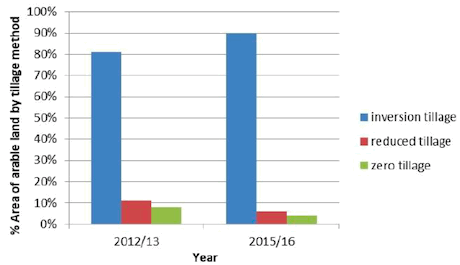
ClimateXChange (2018) reports on different tillage methods for arable land in Scotland (Figure 11). Reduced and zero tillage was used less in 2016 than in 2013 (down from 19% combined in 2013 to 10% combined in 2016), which may suggest an increased risk of soil erosion. The reason for the reduction in use is not known. The Scottish Government (2016) shows the area of agricultural land left bare decreased from 17% in 2013 to 13% in 2016. Land left bare over winter is often as a result of autumn ploughing, allowing the frost and weather to break down the bare soil, which creates an erosion risk. Plant residues and stubbles also declined in this period, whilst winter cropping (which may also leave soil vulnerable to erosion as it relatively more bare) increased. The report states that long term trends cannot be assessed, but it will be useful for this assessment to continue to monitor these trends in the future.
However, field operations can also enhance soil erosion. Tramlines are prone to surface runoff during periods of excess rainfall. For example, autumn spraying of cereals can cause compaction of soil along tramlines, leading to soil erosion associated with winter rainfall (Silgram et al., 2015; Lilly et al., 2018). Tramlines are particularly problematic if they run up and down slope (Vinten et al., 2004). A case study described in Lilly et al. (2018) showed that by removing compaction from control tyres using a spiked harrow reduced soil loss by between 76% and 98%. Using very flexible tyres reduced soil loss by between 36% and 93%. However, a rotary harrow may be more effective than flexible tyres under certain conditions and circumstances. Also, sowing the tramlines had no consistent effect on soil erosion.
b) Sediment control on agricultural land in Scotland
Where runoff concentrates, such as along the edge of the field, a stable, non-eroding watercourse (e.g. shallow grass lined channel) can be established to safely carry runoff away. Vinten et al. (2004) demonstrated that a 1 m width of grassed strip, in a field with 50 slope, produced <10% of the soil loss compared to bare soil (Vinten et al., 2004). Silt fences have been shown by Vinten et al. (2014) to retain sediment upslope (whilst not impacting on erosion processes).
Given future climate change predictions, adhering to policies and associated practices such as Cross Compliance (Good Agricultural and Environmental Condition) and Water Framework Directive will help to reduce future soil erosion (Lilly et al., 2018).
3.4. Costs of soil erosion in Scotland
3.4.1. On-site costs of soil erosion in Scotland
On-site costs are typically incurred by private individuals and include the loss of production of crops, fibre, fuel, fodder, genetic resources, pharmaceuticals, biochemicals and industrial products (Frye et al., 1982).
a) Production costs incurred on-site in Scotland
Davidson and Harrison (1995) note that a general down-slope movement of soil through erosion was changing the distribution of the resource in an erosion survey in the Borders region. Frost and Spiers (1984) reported soil erosion from a single rainfall event caused the loss of 0.15 t ha-1 winter barley (at the time worth £18.00) and 3.75 t ha-1 peas (at the time worth £20.60). In a season with severe erosion, Frost and Spiers (1984) estimated a cost of £26.80 ha-1 , but when averaged over a longer period, they believed the cost would be less because of variable levels of soil erosion.
Frost and Spiers (1984) estimated potential loss of organic matter from a loamy soil at a field sites in Kelso, Roxburghshire. They estimated, via a model, that with an annual rate of soil loss of 25 t ha-1 , the organic matter level would change from 2.5 % (for an intensive cereal rotation on this site) to 1.6%. This loss of 0.225 t ha-1 of organic matter is the equivalent of 14 bags of compost, which if costed at £5 for 16 kg would represent a replacement cost of c. £70 per ha.
b) Mitigation or remedial costs incurred on-site in Scotland
As well as a cost associated with damage caused by the erosion event per se, there are also costs associated with management solutions to reduce soil erosion. This may include extra labour costs, cost of materials and extra fuel costs. However, the evidence for monetary costs associated with erosion control measures for Scotland is quite sparse. Some exceptions to this are given below.
Frost and Spiers (1984) noted that it also took 2 people 3 days with a tractor and trailer to infill gullies resulting from a single rainfall event, at an estimated cost of £150 for the machinery use alone. The same authors estimated that replacing the 0.225 t ha-1 of organic matter lost through soil erosion annually would require the equivalent of 14 bags of compost, which if costed at £5 for 16 kg would represent a replacement cost of c. £70 per ha.
The case study in Lilly et al. (2018) shows how the use of low inflation tyres, a spiked harrow, sowing in tramlines and a rotary harrow to control soil erosion had no effect on fuel use or crop yield. Frost and Ramsay (1996) provided estimates of cost of controlling soil erosion for a range of potential erosion control measures in the Greens Burn Catchment, Perth and Kinross (Table 54). This included the annual net fall in profits (rather than expressed as costs per se) when using a range of erosion control measures, including change in cropping practice, change in rotation and terracing. To prevent eroded soil from leaving the field, a number of silt fences were tested. The cost of this installation in 2012 was £13.55 per m for the product “Terrastop premium”, £13.18 per m for “Square mesh 5 monofilament” and £12.58 per m for “Terrastop Mono 60” (Vinten et al., 2014).
| Option | Erosion Reduction Expected (%) | Annual net fall in profit (%) |
|---|---|---|
| Cultivation change + 20% grass | 50 | 11 |
| Cultivation change + 40% grass | 75 | 40 |
| Spring sown cereals & OSR | 50 | 49 |
| Spring sown cereals & OSR + 20% grass | 75 | 55 |
| Increase Grass to 40% of rotation | 50 | 34 |
| Increase Grass to 60% of rotation | 75 | 58 |
| Diversion terracing (wider spacings) | 50 | 23 |
| Diversion terracing (narrower spacings) | 75 | 54 |
3.4.2. Off-site costs of soil erosion in Scotland
Scottish accounts of the off-site costs of erosion are sparse. Observations of erosion events from 1985 - 2007 by Watson and Evans (2007), recorded the costs of erosion events to include clearing the sediment from blocked culverts under public roads which had to be excavated and re-tarred. Sediment had to be removed from the Aberdeen-Inverness railway near Insch. Deposition of eroded material following an erosion event led to flooding of arable land across Aberdeenshire and Angus (with associated costs of lost production). Wade et al. (1998) reported that an erosion event in 1993 resulted in several hours of work needed to keep the A92 Cupar-St Andrews road clear of sediment. Halcrow Water (2001) reported damage to turbines caused by sediment accumulations near power intakes, leading to increased sediment loads in the water passing through the turbines, which accelerated turbine wear.
3.4.3. The total costs of soil erosion in Scotland
Glenk et al. (2010) propose a useful framework for identifying costs of soil erosion per hectare in Scotland. This covers: on-site costs associated with losses in production (typically incurred by private individuals such as farmers). These were termed ‘private costs’ (PC; e.g. costs for soil nutrient replacement to maintain yields);
on-site costs associated with expenditure on mitigation measures (also usually incurred by private individuals, protecting their land against soil erosion). These were termed ‘mitigation costs’ (MC; e.g. expenditure on measures needed to control soil erosion); off-site costs incurred by society as a whole. These were termed ‘social costs’ (SC; (e.g. CO2 emissions due to soil erosion that ultimately affect global warming, climate change and associated impacts) and; off-site costs of expenditure on infrastructure that will mitigate societal costs (known as ‘defensive expenditure’ (DC), for example, costs of treating drinking water).
These costs may be either incurred by land based industries and businesses at sites where erosion takes place. Once ‘off-field’, the effects of soil erosion are felt at larger spatial and temporal scales, and costs are often borne by society as a whole. A summary of the results is shown below (Table 55). However, the paucity of direct data for Scotland meant that Glenk et al. (2010) had to use figures not specifically derived for Scotland, including from England and Wales.
| Cost category (£2009/ha)a | |||||
|---|---|---|---|---|---|
| Private costs (PC) |
Mitigation costs (MC) |
Social costs (SC) |
Defensive expenditure (DC) |
total | |
| Upper bound estimate (unadjusted mean) | 6.63 | 17.52 | 101.31 | 15.50 | 140.96 |
| Intermediate estimate (adjusted mean)b | 4.53 | 1.71 | 51.47 | 15.50 | 73.21 |
| Lower bound estimate | 0.31 | 0.00 | 12.84 | 0.00 | 13.15 |
Source: adapted from Görlach et al (2004). a Costs initially quoted in €2003 in Görlach et al., these were converted to £2003 using average 2003 £/€ exchange rate (0.692) and deflated to £2009 values using UK GDP deflator (0.866). b Lowest and highest values excluded from calculation of the mean.
4. Discussion
This section discusses the evidence of soil erosion rates, impacts, mitigation measures and associated costs for Scotland. The information available is then put into a wider context by considering evidence either from generic sources or from other appropriate geographical locations. Finally, where gaps are found in the Scottish data that hinder the estimation of total soil erosion costs, alternative approaches are proposed (Section 4.5).
4.1. Rates of soil erosion
The literature review (and number of items published) suggests that soil erosion by water is the dominant erosion process in Scotland (although other forms of soil erosion may be underreported). Even so, soil erosion by water often only affects a small percentage of the area under investigation at any one time. Limitations of the current evidence base for rates of soil erosion in Scotland include a tendency to focus on small areas of severe or catastrophic soil erosion rather than a systematic approach to monitor and assess the more insidious erosion.
Observed erosion rates in arable areas of Scotland range from 0.01 t ha-1 yr-1 to 23.0 t ha-1 yr1 (Table 51), which can be compared with those in England and Wales as collated by Owens et al. (2006; Table 56). It is also possible to compare these rates with a suggested tolerable rate of soil loss of less than 1 t ha-1 yr-1 (Verheijen et al., 2009).
| Wind erosion | Tillage erosion | Co-extraction on roots crops, farm machinery etc. | Water | Scotland water | |
|---|---|---|---|---|---|
| Typical erosion rate range (t ha-1 yr-1 | 0.1 - 2.0 | 0.1 - 10 | 0.1 - 5.0 | 0.1 - 15.0 | 0.01 - 23 t ha yr |
| Land use affected | Arable, upland, some pasture | Arable | Arable | Arable, pasture, upland | |
| Eroded soil exported off field? | Yes | No | Yes | Yes |
From the literature, there are many factors affecting soil erosion rates in Scotland. Baggaley et al. (2017) demonstrated the importance of land use in determining soil erosion rates, which seemed to be more prevalent in agricultural fields that were more intensively managed e.g. the eroding / eroded field was under potatoes within the preceding 8 years, or had had spring or winter cereal crops for 3 or more years. Studies elsewhere have demonstrated the same strong links between land use and soil erosion rates (Evans, 1990a, 2013; Evans et al., 2016). For example, Leeks and Robers (1987) report that the suspended load in a watercourse in the Coalburn catchment in the Pennines over a 5 year period following cultivation under agroforestry was estimated to be the equivalent of ca. 50 years soil loss from the catchment prior to cultivation (Leeks and Robers, 1987).
Other land uses are also associated with soil erosion, especially newly planted and recently felled forest (Table 51). Much of the erosional processes are centred on haul roads and drainage ditches, as well as the prepared / cleared land that has little cover to protect from rainfall and runoff. Data on the proportion of forested areas affected by soil erosion is sparse. Zimke (2016), working in catchments in West Germany remarks that ‘Often, road network densities greater than 100 m per ha can be observed”. Zimke (2016) also notes that skid trails also have a massive influence on hydrological properties in the forest. Unlike roads, skid trails may be harder to identify and because of this could lead to an underestimated percentage of runoff (and associated erosion) from the area.
As well as land use (both current and historic), soil type and slope are often cited in the literature as factors affecting soil erosion rates in Scotland. Other factors include antecedent moisture content, ground cover and presence of tramlines, making it difficult to be certain when, or if and to what extent soil erosion will occur.
In terms of processes operating, almost uniquely in Britain, Scotland experiences soil erosion in arable areas due to snowmelt. The severity of erosion by snowmelt depends on the depth of snow, the distribution of the snow, rate at which the snow melts and the amount and timing of rainfall during the thaw phase (Wade et al., 1998). Information on depth of snow alone is not sufficient to predict erosional response. Rain falling on snow increases erosional risk as it both generates direct runoff and supplies heat for snowmelt, which adds to runoff. These results demonstrate that erosion rates from snowmelt are dependent on circumstances acting in combination rather than on any one dominant influence. In other areas of the world where snowmelt also contributes to soil erosion, research suggests that snowmelt and heavy rains can work in opposition (Rodzik et al., 2009). Erosive runoff from snowmelt helps to develop gullies, but sediment deposition maintains a shallow profile. However, heavy rainfall then removes the accumulated sediment and deepens the gully profile. The role of snowmelt in aggravating soil erosion rates in Scotland may change under future climate change scenarios. Although the occurrence of frost and snowfall may reduce under climate change predictions, warmer springs may result in more rapid thawing of fallen snow, leading to greater runoff discharge (and erosion risk).
Sediment deposits in reservoirs can be informative with respect to rates of erosion at a catchment level. Suspended sediment loads give indirect indication of trends in soil erosion, but direct estimates are difficult to obtain especially in large catchments where many other factors such as runoff from urban areas may contribute to changes in suspended sediment loads (Lilly and Baggaley, 2014b). Sediment studies are less informative about specific rates of soil erosion from soil types and land uses i.e. the origin of the erosion event and its impacts (Duck and McManus, 1988). However, advances in sediment fingerprinting and tracing technology is enabling better interpretation of sediment sources (Owens et al., 2016).
Due to the paucity of field observations in Scotland, researchers have used soil erosion prediction models to estimate the rates of soil erosion. Based on the application of the Pan European Soil Erosion Risk Assessment model (PESERA; Kirkby, Gobin and Irvine, 2003), many areas of Scotland would experience <1 t ha-1 under 1989-1998 rainfall patterns and land uses, although these were primarily upland or grassland areas with expected low erosion risk (Lilly et al., 2009). The arable areas of eastern Scotland on the other hand were predicted to experience >2 t ha-1 yr-1 based on the dominant crop type in each 1km2 grid cell (Lilly and Baggaley, 2014b). This compares with a tolerable rate of soil loss of less than 1 t ha-1 yr-1 (Verheijen et al., 2009). However, as the PESERA model was run on a 1 km grid, small areas of steep slopes and localised high-risk soils are not picked up. Other models such as the Revised Universal Soil Loss Equation (RUSLE) and WaTEM/SEDEM when applied to Scotland using European-scale soil data, tend to predict less soil loss than PESERA (see Appendix 1 of Lilly et al., 2018). However, it is important to note that these models have not been validated for Scotland.
Soil erosion models with sediment yield as an output seem to exaggerate the amount of soil loss and are also difficult to validate (Lilly et al., 2018). Evans et al. (2016) suggest that soil erosion models fail to predict actual erosion rates in Britain because they are often based on severe soil erosion events, which in reality are spatially contained in any individual year. Mean erosion rate across a landscape being a lot lower than individual eroded fields (Evans, 2013). This poses a spatial extrapolation challenge for soil erosion modelling as rates of soil lost cannot be simply extrapolated to all fields in any given year (Evans et al., 2016). Also, as mentioned above, sediment yields, loads and concentrations are not directly linked to the sources / origins of the erosion process. However, soil erosion models do offer a way to examine relative changes in soil erosion rate under different land uses and changing climates (Lilly et al., 2018). Current ruled based models do allow an assessment of soil erosion risk to help minimise impact.
In conclusion, the current review has found few studies that quantify rates of soil erosion observed in Scotland. This evidence gap is acknowledged by Glenk et al. (2010), whose analysis had to be “based on studies from outside Scotland, such as the EU report prepared by Ecologic (Görlach et al., 2004) and the ADAS study commissioned by Defra (ADAS, 2006) and the Soil Strategy for England Supporting Evidence Paper (Defra, 2009)”. The Soil Monitoring Action Plan (SoilMAP) highlighted the need for more systematic data to assess the current state of soil erosion in Scotland (Black et al., 2012). This is supported by a recent report by the Committee on Climate Change (2019), who report that “there are insufficient data and metrics to assess the vulnerability of soils to climate impacts” and “appropriate metrics have not yet been identified or measured for rates of soil erosion, including the uptake of soil conservation measures by farmers”.
4.2. Impacts of soil erosion
There is some evidence of the impacts of soil erosion on different ecosystem goods and services in Scotland. Understanding these impacts and finding evidence of them is the first step in estimating the costs of soil erosion.
4.2.1. On-site impacts of soil erosion
Single soil erosion events rarely cause significant problems for farmers, but over time may impact on the long-term sustainability of the land and can still result in loss of ecosystem goods and services (Davidson and Harrison, 1995; Carling et al., 2001).
A loss of provisioning services due to soil erosion is often the first on-site impact that most people think about. However, there is very little evidence of the quantitative loss of crop yield due to soil erosion in Scotland. The work by Frost and Spiers (1984) near Kelso is one of the most comprehensive works on the impact of soil erosion on land capability in Scotland. Frost and Spiers’ work highlights how difficult it can be to attribute losses in production to the rate of soil loss. Lal and Moldenhauer (1987) supported the idea that “although the visual effects of soil erosion can be spectacular, the effects of erosion on crop yields are hard to quantify”. This has led to reports of soil erosion enhancing yields; having no effect on yields; slightly reducing yields; to causing complete crop failure. Lal and Moldenhauer (1987) argued that the effects of soil erosion can be cumulative and take a long time to impact yield. The confusion over soil erosion / productivity relationships is due to the complexity of the system and the multiple influences that affect crop performance and yield (Lal and Moldenhauer, 1987). Where the soil is deep, the on-site impact of erosion is not expected to threaten crop production for many years (Bakker et al., 2007; Evans, 2017).
Towers et al., (2006) also suggest that soil erosion in Scotland had only minor impacts on soil functions including food and biomass production, carbon storage and gas balance, habitats and biodiversity, heritage and regulating water flow and quality, although regulating water flow (quantity) and quality was locally important.
Frost and Spiers (1984) also considered the potential loss of soil moisture storage due to soil erosion. It is acknowledged that a loss in soil depth (for example by soil erosion) leads to a reduction in available storage space for water within the depleted topsoil and the reduced soil moisture storage capacity of subsoils exposed after erosion of the topsoil (Lal and Moldenhauer, 1987). A reduction in soil moisture storage capacity can, in dry years, cause plant stress, reducing plant quality and quantity (Lal and Moldenhauer, 1987). However, in wetter years, when there is still a sufficient reservoir of water for a plant to access, the impact of soil erosion will be less obvious (Lal and Moldenhauer, 1987). The ability of the soil to store water not only affects plants but also determines soil hydrological functions such as the time between start of rainfall and the generation of overland flow. This function is an important factor affecting soil erosion risk (Lilly and Baggaley, 2014b).
In the Scottish Soil Framework (2009) it is suggested that soil erosion can expose artefacts leading to their degradation and loss. The work by Davidson et al. (1998) gave a good account of how tillage erosion (e.g. soil disturbance using a plough) may impact archaeological sites. Others have attributed ploughing as the greatest agent of attrition to archaeological sites around the world (Wilkinson et al., 2006). However, no other studies were found for Scotland that related other soil erosion processes (e.g. by water) to potential loss or damage of historical artefacts.
Other on-site impacts of soil erosion on ecosystem goods and services have been reported elsewhere (Table 57), but no published data of these impacts (e.g. loss of soil biota, loss of above ground biota and reduced landscape value) was found specifically for Scotland in the literature review. This suggests there is an evidence gap for Scotland.
| Ecosystem services | Soil erosion impact | |
|---|---|---|
| Provision | Support of food, fuel, fodder and fibre production | Loss of soil depth leading to stunted root development and limited availability of water and nutrients) Direct crop damage (e.g. displacement of crops; wind abrasion) |
| Providing raw materials | Loss of soil depth | |
| Regulation | Regulating the flow of and filtering substances from water | Reduced water holding capacity of exposed subsoils |
| Storing carbon | Reduced soil carbon (organic matter content) in subsoil | |
| Soil fertility / quality | Reduced soil productivity | |
| Supporting | Support of below-ground biodiversity | Loss of soil biota |
| Support of above-ground biodiversity | Loss of (above ground) biodiversity | |
| Cultural | Protection of cultural heritage and archaeology |
Exposure of archaeological features leading to increased risk of damage |
| Cultural landscapes | Reduced landscape value | |
4.2.2. Off-site impacts of soil erosion
The present review and others (e.g. Frost and Spiers, 1984; Frost and Speirs, 1996) have found little supporting evidence within Scotland for the off-site impacts of soil erosion. Exceptions to this include the sedimentation of reservoirs (Duck and McManus 1988 & 1990). Potential off-site impacts of soil erosion on the wider environment are also discussed by Lilly and Baggaley, 2014a. In the Scottish Soil Framework (2009), it is suggested that soil erosion in Scotland contributes to increased suspended sediments and turbidity in watercourses, which can diminish water quality and damage aquatic life, including salmon spawning grounds. Sediment associated pollutants, such as phosphates, were also thought to contribute to eutrophication of water bodies.
The evidence of off-site soil erosion impacts in Scotland lacks quantification. Part of the problem seems to be that off-site impacts are not always considered when making risk assessments of soil erosion (Boardman et al., 2019). However, recent soil erosion risk mapping has been aimed specifically at reducing the impact of land-based activities on water quality (Lilly et al, 2014a).
In other areas of the UK and Europe, even in areas where soil erosion in not considered to be an on-site problem, off-site damages such as diffuse pollution and muddy floods have still been reported (Boardman et al., 2019). For example, in the Wissey catchment in Norfolk, Eastern England, where soils in the catchment were only considered to be at slight or moderate risk of erosion (Evans, 1990), sediment on the riverbed was still observed to be having an impact on fish stocks (River Wissey Partnership, 2014). In the Rother Valley, West Sussex, and other UK rivers, excessive sediment loads in the river have been reported as causing damage to the local trout fisheries through sedimentation of gravel-beds used by the trout as spawning grounds (Sear, 1996; Kemp et al., 2011). Excessive sediment also affects invertebrates causing an imbalance in the aquatic ecosystem (Bond and Downes, 2003; Yeakley et al., 2016; Conroy et al., 2018). Nationally, Collins et al. (2009) suggest that 76% of suspended sediment in rivers is from agricultural sources.
In a report by Halcrow Water (2001), accumulation of sediments in reservoirs in Britain are reported to cause a range of problems:
- Increased flood risk due to greater likelihood of reservoir / dam overtopping in storm events
- Reduced storage capacity in the reservoir
- Build-up of sediment against the dam causing instability in some structures
- Sediment load in intake water leading to accelerated wear and tear on turbine blades
Despite these studies, Spencer et al. (2008) claim there is insufficient evidence available to quantify off-site damages from soil erosion. Other off-site impacts of soil erosion on ecosystem goods and services have been reported elsewhere (Table 58), but little evidence of these impacts was found specifically for Scotland in the literature review. This suggests there is an evidence gap for Scotland. Comparing the current evidence for off-site impacts of soil erosion for Scotland with the wider known impacts, reveals several data gaps for Scotland including rates and impact on siltation / deposition of eroded material in rivers, effects on aquatic habitats, eutrophication of water bodies and recreational water quality.
| Ecosystem services | Soil erosion impact |
|---|---|
| Support of food, fuel, fodder and fibre production | Reduced yields (food, fuel, fodder and fibre production) due to sedimentation |
| Energy | Sedimentation affecting capacity of hydroelectric reservoirs Sediment causing abrasion to water turbines |
| Drainage / discharge of water | Siltation of water courses |
| Flood regulation | Siltation of water courses which affects their water holding storage capacity, increasing the risk of flood events (exceeding bankfull discharges) |
| Provision of drinking water | Water treatment costs to remove pollutants & sediments |
| Reservoir capacity | |
| Water quality | Water pollution from chemicals adsorbed onto eroded soil (especially phosphorus) Eutrophication of lakes |
| Infrastructure | Obstruction of roads, culverts, drainage ditches etc. due to sedimentation |
| Wetland habitat | Degradation of riverine / wetland habitats due to siltation and pollution Sediments affecting wetland biodiversity Increased water turbidity of receiving waters, affecting aquatic habitats such as salmon spawning beds and freshwater pearl mussels |
| Recreation | Siltation of waterbodies affecting fish habitat (angling) and navigable waterways (boating, tourism). |
| Health | Air pollution by soil particles (wind erosion) |
4.3. Mitigation of soil erosion
The Scottish Soil Framework identifies six policies protecting soils, including planning, conservation and biodiversity, water quality and flooding, pollution, land use and management and cultural heritage. However, finding the evidence related to the uptake, use (and effectiveness) of soil erosion mitigation measures in Scotland is challenging. Whilst the current review has found only limited evidence of the use of erosion mitigation measures in Scotland, this should not be interpreted to mean that they are not necessarily being used: it could be their use is simply under-reported. The Committee on Climate Change (2019) call for better metrics on the uptake of soil conservation measures by farmers. Examples of mitigation measures from elsewhere are discussed below in terms of their suitability in Scotland.
While cover crops are often put forward as an option to control soil erosion during winter months in England, over-winter ground cover is often difficult to achieve in Scotland. This is because of late harvesting and subsequent late sowing leading to poor establishment (Vinten et al., 2004), although a well-established cover crop may provide a more complete cover than a poorly established winter cereal. Cover cropping may also have low uptake because their residues are also slow to anaerobically decompose in the spring in Scotland (Vinten et al., 2004).
The Demonstration Test Catchments (DTCs) were established by the Department for Food and Rural Affairs (Defra) to gather data on the effectiveness of options to mitigate diffuse agricultural pollution from a farmed landscape. Outputs from this scheme are beginning to provide important evidence. Whilst it is recognised that the environmental conditions of the DTC catchments are very different to Scotland, some principles of soil erosion mitigation are transferable. For example, in the Wissey DTC, observations have shown that fragmented mitigation is less likely to be effective at reducing diffuse pollution (usually associated with soil erosion). This requires most farmers in any catchment or landscape to sign up to a range of mitigation options in order to effectively reduce the off-site impact of soil erosion. Boardman et al. (2019) suggest that because off-site damage may not be caused by high rates of soil erosion from fields, mitigation methods should also focus on interrupting the flow of runoff, encouraging infiltration and diverting flows from sensitive receiving areas. A long-term study in north Norfolk, UK, corroborated the effectiveness of interrupting connectivity on reducing soil erosion (Evans, 2006).
Soil erosion mitigation methods used in the UK to reduce erosion rates on-site and reduce offsite sediment loads are listed in Table 59. Posthumus et al. (2015) estimated the costeffectiveness of some of these measures (see below). However, few of these measures are mentioned in the reviewed literature concerning Scotland specifically. It is uncertain whether this is because the measures are not used, or are simply not reported. This represents an evidence gap in estimating the total costs of soil erosion (and its mitigation) in Scotland.
| Category | Mitigation method |
|---|---|
| Land use | Convert arable land to extensive grassland Grow crops less damaging to the soil at time of harvest (avoid sugar beet and potatoes) |
| Soil management | Establish cover crops in the autumn |
| Cultivate land for crop establishment in spring rather than autumn | |
| Adopt minimal cultivation systems | |
| Cultivate compacted tillage soils | |
| Cultivate and drill across the slope | |
| Leave autumn seedbeds rough | |
| Avoid tramlines over winter | |
| Establish in-field grass buffer strips | |
| Loosen compacted soil layers in grassland fields | |
| Maintain and enhance soil organic matter levels | |
| Allow field drainage systems to deteriorate Better timeliness of cultivation, drilling and harvesting |
|
| Livestock management | Reduce overall stocking rates on livestock farms |
| Reduce the length of the grazing day or grazing season | |
| Reduce field stocking rates when soils are wet | |
| Move feed and water troughs at regular intervals | |
| Farm infrastructure |
Fence off rivers and streams from livestock |
| Construct bridges for livestock crossing rivers and streams | |
| Re-site gateways away from high-risk areas | |
| Establish new hedges | |
| Establish riparian buffer strips | |
| Establish and maintain artificial (constructed) wetlands Construct retention ponds Silt fences, straw bales and filter socks Grass waterways |
Several studies have looked at the effective of mitigation measures in controlling runoff, soil erosion and loss of phosphorus (P) (e.g. Posthumus et al., 2015; Table 60). Different mitigation measures were assessed to have different effectiveness (expressed as % reduction). These results will reflect the reduction in soil erosion rates and associated impacts. For example, infield buffer strips were estimated to reduce runoff, soil erosion and phosphorus loss by 50%, 25% and 25% respectively, compared with having no buffer strip installed in the field.
| Mitigation measure | Reduction of runoff | Reduction of soil loss | Reduction of P loss |
|---|---|---|---|
| Cover crops (winter) | 10% | 10% | 25% |
| Cover crops (under sown maize) | 10% | 10% | 25% |
| Geo-textiles | 50% | 25% | 25% |
| Mulching | 25% | 50% | 50% |
| In-field buffer strips | 50% | 25% | 25% |
| Riparian buffer strips | 50% | 50% | 50% |
| High density planting | 50% | 25% | 25% |
| Crop rotation (spring crops) | 2% | 2% | 50% |
| Timeliness | 2% | 2% | 50% |
| Land use change (arable to pasture) | 50% | 50% | 25% |
| Agro-forestry | 50% | 50% | 50% |
| Shelterbelts | 10% | 10% | 25% |
| Subsoiling | 2% | 2% | 25% |
| Drainage | 2% | 2% | 25% |
| Reduced tillage | 2% | 25% | 25% |
| Zero tillage | 10% | 25% | 50% |
| Tramline management | 80% | 80% | 80% |
| Coarser seedbeds | 2% | 25% | 25% |
| Stocking density | 10% | 10% | 25% |
| Contour ploughing | 50% | 50% | 50% |
| Swales | 50% | 25% | 25% |
| Earth banks | 50% | 25% | 25% |
4.4. Costs of soil erosion
The ‘on-site’ and ‘off-site’ costs of soil erosion are incurred in many different ways, affecting a diverse range of ecosystems services and benefits to people, over a range of spatial and temporal scales. This makes estimating the costs of soil erosion particularly challenging. This may explain the limited quantified evidence on soil erosion costs in Scotland.
4.4.1. On-site costs of soil erosion
a) Costs of reduced crop yields due to soil erosion
Davidson and Harrison (1995) discuss the impact of soil erosion on Scottish crop yields (and therefore farm income). Studies from elsewhere have found that yield reductions are typically between 0.03 and 0.05% per tonne soil lost (e.g. Biot and Lu, 1995; Hodges and Arden-Clarke, 1988; Owens et al., 2006). Evans (1996) estimated that loss of productivity from loss of soils and nutrients amounts to £9 million for England and Wales. The degree of yield loss depends upon the soil profile characteristics, the crop grown, soil management, and the microclimate (Lal, 1985; Posthumus and Stroosnijder, 2009). Impact of soil erosion on soil productivity depends on the quality and quantity (i.e. depth) of remaining soil and is thus location-specific.
The effect of soil erosion on crop yields is frequently given in relation to a change in soil depth (Pimentel et al., 1995; Lal, 1998). Observed reductions show wide variation, depending on the crop grown (e.g. rooting character), soil profile characteristics (e.g. nutrient storage and availability; water holding capacity), existing soil and crop management, and the site’s weather and microclimate (Pimentel et al., 1995; Lal, 1998). Since erosion induced yield declines are of considerable importance, especially in low input agriculture, modelling tools such as EPIC (EPIC: Erosion-Productivity Impact Calculator; http://epicapex.brc.tamus.edu/) have been developed to examine long-term effects of various components of soil erosion on crop production.
Based on a variety of measured data, Pimentel et al. (1995) found that as a result of soil erosion, crop yields declined by 20% over a period of 20 years. Graves et al (2011) developed a simplified approach, using the relationships developed by Pimentel et al. (1995) to predict erosion induced yield penalties (Table 61; Appendix C). The total yield penalty was calculated to be £5.4 million per year for England and Wales, much of this associated with silts and sands, especially where under arable and horticultural use.
| Yield penalty (%) | |||
|---|---|---|---|
| Over 20 years | Average annual | per mm loss of soil depth due to erosion | |
| Water runoff | 7 | 0.35 | 0.3 |
| Nitrogen Phosphorus Potassium |
8 | 0.4 | 0.3 |
| Soil depth | 7 | 0.35 | 0.3 |
| Organic matter | 4 | 0.2 | 0.1 |
| Water holding capacity | 2 | 0.1 | 0.1 |
| Soil biota | 1 | 0.05 | 0.0 |
| Total on-site | 20 | 1 | 0.74 |
b) Erosion induced losses in soil carbon (C) and nutrients (N, P and K)
The literature review found no economic data on these losses specifically for Scottish soils. Theoretically, the costs of erosion induced losses of soil carbon and nutrients (N, P and K) can be estimated from the following information:
- the content of C and nutrients in the soil (that may be lost through soil erosion processes);
- the degree of soil loss, with associated C and nutrients within the eroded soil;
- the economic cost of the C and nutrient losses, in terms of the cost of replacing them.
c) on-site expenditure on soil erosion mitigation measures
Despite the work by Lilly et al. (2018) and Frost and Ramsay (1996), the evidence for on-site expenditure on soil erosion mitigation measures in Scotland is sparse. Frost and Spiers (1984) discuss the additional field operations (and their costs) needed to rectify any damage done by soil erosion, including addition of organic matter to replace that carried away in the eroded soil.
Information that is missing on mitigation measures in Scotland includes:
- investment costs (materials and implementation costs)
- maintenance costs
- hindrance of farming operations
- loss of productive land; and
- loss of high value land use in case of land use change.
These costs, however, may vary from field to field, depending on soil type, land use, and skills of the farmer. Some mitigation measures will be easier to implement, less costly and have a greater effectiveness than others. Table 62 contains an example of the different types of onsite costs of mitigation measures and an average annual cost per hectare (taken from Posthumus et al., 2015). Dividing the investment costs by the lifetime of the mitigation measures, and adding the annual maintenance costs gives the average annual cost.
| Mitigation measure | Investment costs (£ ha-1 ) | Maintenance costs (£ ha-1 ) | Hindrance to farming operations | Loss of agricultural production | Total annual cost (£ ha-1 ) |
|---|---|---|---|---|---|
| Cover crops (winter cover) | 148 | 25 | None | Switch from winter cereals to spring cereals : £175 |
348 |
| Cover crops (under sown) | 75 | 25 | None | None | 100 |
| Geotextiles | 257 | 5 | Negligible | £27 (cereals) to £47 (general cropping) | 80 to 100 |
| Mulching | 100 | 0 | None | None | 50 |
| In-field buffer strips (6m) | 32 | 1.5 | Some | £32 (cereals) to £56 (general cropping) | 40 to 64 |
| Riparian buffer strips (6m) |
32 | 1.5 | None | £32 (cereals) to £56 (general cropping) | 40 to 64 |
| High density planting | 5 | None | None | None | 5 |
| Crop rotation | None | 25 | None | Change in value of agricultural production | -6 to 306 |
| Timeliness | None | 70 | Potentially high | Potentially high | 70 |
| Mitigation measure | Investment costs (£ ha-1 ) | Maintenance costs (£ ha-1 ) | Hindrance to farming operations | Loss of agricultural production | Total annual cost (£ ha-1 ) |
|---|---|---|---|---|---|
| Land use change (arable to grass) |
Potentially very high if change in agricultural enterprise | None | None | Cereals to pasture: £281; General cropping to pasture: £607 | 281 to 607 |
| Agro-forestry | 503 | Variable | Huge hindrance | Potentially high: major change in land use | 25 |
| Shelterbelts | 670 | 0 | Low | £11 (cereals) to £19 (general cropping) | 44 to 52 |
| Subsoiling | 48 | None | None | None | 16 |
| Drainage | 2,000 | Negligible | None | None | 80 |
| Reduced tillage |
None | 50 | None | £32 (cereals) | 82 |
| Zero tillage | Possibly purchase of specialist machinery | 67 | None | £32 (cereals) | 99 |
| Tramline management | None | 20 | None | None | 20 |
| Coarser seedbeds | None | 34 | None | None | 34 |
| Stocking density | None | 40 | None | £85 ha-1 for dairy (RPA 2003) |
125 |
| Contour ploughing | None | 32 | not suitable for slopes > 10% | None | 32 |
| Swales | 212 | Negligible | May cause some hindrance | Dependent on size swale & land use | 14 |
| Earth banks | 218 | Negligible | Potentially high | £11 (cereals) to £19 (general cropping) | 55 to 63 |
These costs of soil erosion mitigation measures can be off-set by the benefits these options bring. Examples of these are given in Table 64 (Posthumus et al., 2015). These include savings in field operations (labour and fuel), positive impacts on yield / productivity, financial benefits of ‘by-products’, and any applicable agri-environment payment schemes (Table 64). Knowing the costs and benefits of different soil erosion mitigation measures allows for cost benefit analysis of the different options (Table 66; Posthumus et al., 2015).
| Mitigation measure | Cost savings in field operations | Impacts on yield | Resulting byproducts | Agrienvironment payments (if applicable) | Total annual benefit (£ ha-1 ) |
|---|---|---|---|---|---|
| Cover crops (during winter) | Higher Level Scheme (HLS): £200 ha-1 |
200 | |||
| Cover crops (under sowing maize) | None | Retain status quo | HLS: £18 ha-1 | 18 | |
| Geotextiles | None | Retain status quo | None | None | 0 |
| Mulching | None | Increase | None | None | 0 |
| In-field buffer strips (6m) | None | Retain status quo | HLS: £400 ha-1 | 24 | |
| Riparian buffer strips (6m) | None | None | HLS: £400 ha-1 | 24 | |
| High density planting | None | Increase (due to crop density) +10%? |
None | None | |
| Crop rotation | None | None | Depending on changes | None | 0 |
| Timeliness | None | None | None | None | 0 |
| Land use change (arable to extensive grass) |
None | N/A | HLS: £210 ha-1 | 210 | |
| Agro-forestry | None | Retain status quo | Depending on tree species | HLS: £190 ha1 (creating orchards); £95 ha-1 (managing orchards) |
105 |
| Shelterbelts | None | Retain status quo | None | HLS: £5 m-1 (for planting); £0.27 m-1 (maintenance) |
52 |
| Subsoiling | None | Increase? | None | None | 0 |
| Drainage | None | Increase? | None | None | 0 |
| Reduced tillage | Cuttle et al. 2007: £40 ha-1 | Retain status quo | None | None | 40 |
…….continued
| Mitigation measure | Cost savings in field operations | Impacts on yield | Resulting byproducts | Agrienvironment payments (if applicable) | Total annual benefit (£ ha-1) |
|---|---|---|---|---|---|
| Zero tillage | Retain status quo | None | HLS: 70 | 70 | |
| Tramline management | None | None | None | None | 0 |
| Coarser seedbeds | Rolling: £26 ha-1 (Nix 2009) |
Retain status quo | None | None | 26 |
| Stocking density | None | Retain status quo | None | HLS: 40 | 40 |
| Contour ploughing | None | Potential yield increase (16%) cereals (Quinton and Catt, 2004) | None | None | 85 |
| Swales / sediment traps | None | None | None | CSF: £6 m-2 (investment costs) | 1 |
| Earth banks | None | None | None | HLS: £3 m-1 | 60 |
| Mitigation measure | Lifetime of the measure (years) |
Annual financial costs (£ ha-1) |
Annual financial benefits (£ ha-1) |
Net annual benefit (£ ha-1) |
Benefit-cost ratio (for 5 year period) |
|---|---|---|---|---|---|
| Cover crops (during winter) | 1 | 315 | 200 | -115 | 0.64 |
| Cover crops (under sowing maize) | 1 | 100 | 18 | -82 | 0.18 |
| Geotextiles | 5 | 80 to 100 | 0 | -99 to -79 | 0 |
| Mulching | 2 | 50 | 0 | -50 | 0 |
| In-field buffer strips (6m) | 5 | 40 to 64 | 24 | -40 to -16 | 0.38 to 0.60 |
| Riparian buffer strips (6m) | 5 | 40 to 64 | 24 | -40 to -16 | 0.38 to 0.60 |
| High density planting | 1 | 5 | 0 | -5 | 0 |
| Crop rotation | 1 | -6 to 306 | 0 | -306 to 6 | 0.02 to 7.0 |
| Timeliness | 1 | 70 | 0 | -70 | 0 |
| Land use change (arable to extensive grass) |
1 | 281 to 607 | 210 | -397 to -71 | 0.35 to 0.75 |
| Agro-forestry | 20 | 25 | 105 | 80 | 1.32 |
| Shelterbelts | 20 | 44 to 52 | 52 | 0 to 8 | 0.83 to 0.88 |
| Subsoiling | 3 | 16 | 0 | -16 | 0 |
| Drainage | 25 | 80 | 0 | -80 | 0 |
| Reduced tillage | 1 | 82 | 40 | -42 | 0.49 |
| Zero tillage | 1 | 99 | 70 | -29 | 0.71 |
| Tramline management | 1 | 20 | 0 | -20 | 0 |
| Coarser seedbeds | 1 | 34 | 26 | -8 | 0.78 |
| Stocking density | 1 | 125 | 40 | -85 | 0.47 |
| Contour ploughing | 1 | 32 | 85 | 54 | 2.13 |
| Swales / sediment traps | 15 | 14 | 1 | -13 | 0.07 |
| Earth banks | 5 | 55 to 63 | 60 | -2 to 6 | 0.98 to 1.12 |
4.4.2. Off-site costs of soil erosion
Few studies quantified the wider, off-site costs of soil erosion in Scotland. Watson and Evans (2007) and Wade et al. (1998) recorded the costs of erosion linked to clearing sediment from roads and Halcrow Water (2001) reported damage to turbines caused by sediment accumulations near power intakes, leading to increased sediment loads in the water passing through the turbines, which accelerated turbine wear.
There is little data on the impacts on water quality from eroded soil reaching watercourses. This represents a significant evidence gap, but studies from elsewhere can be used to estimate the likely off-site costs of soil erosion in Scotland. For example, the damage caused in waterbodies by nutrients carried on eroded sediments was estimated for England and Wales by Graves et al (2011; Table 67). Specifically, the off-site damage cost associated with N in the eroded soil in rivers and canals was estimated to be £2.9 million. The off-site damage cost associated with the P in eroded soil in lakes (e.g. through processes such as eutrophication) was estimated to be £6.8 million (Table 70).
| Source | Pollutant | Cost | Unit | |
|---|---|---|---|---|
| Environmental water quality | Rivers, canals | NO3-N Nitrate | 161 | £ t-1 |
| Freshwater lakes | P | 1,407 | £ t-1 | |
| Transitional water | NO3-N Nitrate | 8.9 | £ t-1 | |
| Drinking water quality | NO3-N Nitrate | 172 | £ t-1 | |
| Soil / sediment | 15.4 | £ t soil-1 | ||
However, data on the proportion of C in eroded material that is released to the atmosphere to form CO2 is lacking. Lal (2003) proposes that approximately 20% of the soil C that is eroded each year is emitted to the atmosphere as CO2. The ratio of organic C in the soil to CO2 in the atmosphere is given as 3.67 (Williams, Audsley and Sandars, 2006), and the assumed quantity of eroded C emitted to the atmosphere was multiplied by this ratio to obtain its Global Warming Potential (t CO2e). Using these assumptions, the cost of GHG emissions from eroded soils in England and Wales was estimated by Graves et al. (2011) to be £8.5 million (Table 70).
There are also few studies that quantify the costs of defensive or remedial measures that reverse the off-site damage caused by soil erosion in Scotland. Other studies (e.g. (Anthony et al., 2009) have derived a ‘per unit’ cost (£ 172 t-1 NO3-N) for removal of nitrate from drinking water. Anthony et al. (2009) also derived a ‘per unit’ cost of £15.4 t-1 to remove sediment from drinking water. From these estimates, Graves et al. (2011) estimated the costs of removing sediment from drinking water to be £45 million for England and Wales.
Although no data was found for Scotland, the off-site costs of dredging sediment from water courses was estimated for England and Wales as £9.9 million, with an agricultural apportionment of 95%, giving a total cost (adjusted to 2009) of £9.8 million (Graves et al., 2011).
4.4.3. Overview of soil erosion costs
The literature review reveals that evidence on soil erosion costs in Scotland has not expanded significantly since Glenk et al’s work in 2010. There are difficulties in gathering data on costs of soil erosion and often the figures reported are not specific to Scotland (e.g. Alam, 2018). The paucity of direct data for Scotland meant that figures not specifically developed for Scotland had to be used by Glenk et al. (2010), namely for England and Wales. Transfers of soil related costs were made to Scotland, on the basis of rough apportionments from England and Wales’ estimates and relative agricultural activity. Glenk et al. (2010) admit that transferring these generic estimates of soil erosion costs to Scotland “may not be valid beyond giving the broad range of potential values”. This is because of:
- Differences in soil erosion rates and frequencies;
- Differences in soil types;
- Crop types: some may not be relevant to Scotland;
- Crop yield, as affected by environmental conditions and year of study, which reflects trends in yield over time;
- Crop price; this may be related to crop attributes (quality) or year of study (reflecting fluctuations in market prices); and
- Input prices; these will vary according to the system being used or year of study.
Another example of this approach is given in the Environmental Accounts for Agriculture (Jacobs and SAC, 2008; as further developed by Defra), which bases soil erosion costs on channel dredging costs in England and applies these to Scotland on the basis of the relative area of arable land. This calculation gives a damage cost estimate for Scotland of £1.3m in 2008 for example.
The present study will improve on Glenk et al.’s (2010) methodology by taking these issues into account specifically for each of the identified case study catchments (Work Package 3). This approach is recommended by Glenk et al (2010), who “suggest that soil erosion costs estimates for Scotland could be obtained by a case study approach in a small number of representative catchments where there is an identified risk of soil erosion”. Where possible, actual measured / observed rates of erosion in those catchments, their associated impacts and mitigation measures will be used to estimate total costs of soil erosion. However, where data are missing, ‘proxy’ data from elsewhere may have to be used to produce an estimate of soil erosion costs in Scotland (see Section 4.5).
4.5. Data gaps and how to address them
As presented above, the evidence on soil erosion rates in Scotland, their impacts, mitigation measures and associated costs is currently limited. The following section will propose a methodology that will allow the costs of soil erosion to be estimated for the study catchments, where there are gaps in the information.
4.5.1. Estimating soil erosion rates in the study catchments
Where observed data on soil erosion rates is not available for the chosen case study catchments in Scotland, these could be estimated from a ‘look up’ table that presents typical erosion rates from similar sites in Scotland where data is available. The look up table is populated with actual erosion rates observed for a combination of factors affecting erosion (e.g. soil type, slope and land use). This approach was used by Graves et al. (2010) who found similar gaps in the evidence on soil erosion rates in England and Wales. Here, observed erosion rates for soil texture / land use combinations were used to populate the table (Table 68). It was assumed that wherever the same combination of factors occurred, similar erosion rates would be expected. It should be noted that rainfall was not taken into account. This is because land use was deemed more influential on erosion rates than annual precipitation (Evans, 1990b). A similar table could be created using Scottish data where available.
It should be noted that erosion occurs only on a proportion of the total land area in each category each year. The method developed by Graves et al (2011) necessitates an estimate of these proportions across the defined soil type / land use / slope steepness categories. This can be based on the soil erosion risk map (Lilly and Baggaley, 2018) and land cover to assess the actual percentage.
| Land use | Soilscapes | |||||||
|---|---|---|---|---|---|---|---|---|
| Clay | Typical rate* (t ha-1 yr-1 | Silt | Typical rate* (t ha-1 yr-1) | Sand | Typical rate* (t ha-1 yr-1) | Peat | Typical rate* (t ha-1 yr1) | |
| Urban | L | 0 | H | 10 | H | 5 | n/a | n/a |
| Horticulture | L | 2 | H | 20 | H | 5.08 (Evans, 2002) | H | 15 |
| Arable intensive | L | 1.92 (Evans, 2002) |
H | 22.1 (Morgan et al., 1987) 22.7 (Robinson and Boardman, 1988) |
H | 16 (Reed, 1983; 1986) 22.1 (Morgan et al., 1987) 22.7 (Robinson and Boardman, 1988) | H | 20 |
| Arable extensive | L | 0.9 (Deasy et al., 2008; 2009) < 2 (Cooper, 2006) |
M | 3.2 (Deasy et al., 2008; 2009) 4.5 (Brazier, 2004) 11.2 (Fullen, 1992) |
H | 0.4 (Deasy et al., 2008; 2009); 0.75 (Quinton and Catt, 2004); 1.48 (Brazier, 2004) 3.47 (Cooper, 2006) 11.2 (Fullen, 1992) |
H | 10 |
| Grassland improved | L | 0.36 (Brazier, 2004) | M | 4.09 (Evans, 2002) 4.89 (Brazier, 2004) |
M | 4.09 (Evans, 2002) | H | 7 |
| Grassland unimproved | L | 1.29 (Brazier, 2004) | M | 2.07 (Brazier, 2004) | M | 1.5 | H | 10 |
| Rough grassland | L | 0.05 | M | M | 0.22 (Brazier, 2004) | H | 10 | |
| Forestry | L | 0.01 | L | 0.5 | L | 0.05 | M | 0.7 |
| Woodland | L | 0.01 | L | 0.5 | L | 0.05 | M | 0.7 |
| Wildscape | L | 0.01 | L | 0.5 | L | 0.05 | M | 0.7 |
*Notes:
Data from Evans (2002) do not specify soil type, but do specify crop / land use. Reasoned assumptions have been made as to which soil type is used for various crops (e.g. oilseed rape on heavy (clay) soil).
Data from Brazier (2004) derives from Evans (1988, 1993) and Skinner and Chambers (1996). These erosion rates relate to soil types only: No land use data are given. Reasoned assumptions have been made regarding likely land use for different soil types and resulting erosion rates as presented in Brazier (2004).
Data on arable soil erosion rates have been split between intensive and extensive arable: highest rates have been assumed to apply to intensive arable; lowest rates are assumed to apply to extensive arable.
This information can then be used to calculate an estimated gross erosion (t) for each land use/soil type/slope category, and; b) an estimated mean erosion (t ha-1) for each land use/soil type/slope category at the local, regional and national scale. Using this approach for land use and soil type alone, Graves et al (2011) estimated soil erosion rates in England and Wales to be 2.9 Mt yr-1, which is similar to the 2.2 Mt yr-1 estimate given by the Environment Agency.
Where soil erosion mitigation measures are used in the study catchments, their effectiveness in controlling erosion (Table 60) can be used to reduce expected soil erosion rates.
4.5.2. Estimating the impacts of soil erosion in the study catchments
Simple soil erosion / yield penalty models (e.g. Pimentel et al., 2015) can be used to predict the impact of soil erosion on yields (Table 61), taking account of the soil erosion rates in the study catchments (see Section 4.5.1).
To calculate the losses in soil carbon and nutrients due to soil erosion processes, a similar approach to Graves et al. (2011) can be used. The National Soil Inventory topsoil dataset was used to obtain the mean soil carbon (C), phosphorus (P) and potassium (K) content of each of the land use/soil type categories (and associated erosion rates as shown in Table 68. The results are given in Appendix C. Whilst this approach estimates the quantity of C, N, P and K in the soil, it is worth noting that erosion selectively takes the most important components of the soil first and eroded soil can typically contain three times more nutrients than the soil left behind (Sharpley, 1980; Lal, 1998; Ali I, Khan and Bhatti, 2006). Enrichment ratios measure the relative concentrations of carbon and nutrients in the deposited material (sediment) and in the soil from which that eroded material came. The range of enrichment ratios used by Graves et al (2010) to estimate nutrients and carbon lost in eroded soil are shown in Table 69.
| Nutrient | Range of enrichment ratios | Mean Enrichment Ratio (ER) |
|---|---|---|
| Total P | 1.32 - 3.04 (Zheng et al., 2005) 1.47 (Sharpley, 1985) 2.79 (Ali et al., 2006) |
2.15 |
| OC / OMC | 1.08 - 1.4(Zheng et al., 2005) 0.9 - 2.6 (Schiettecatte et al.,) 2.00 (Sharpley, 1985) 1.23 (Ali et al., 2006) |
1.56 |
| Total N | 0.89 - 1.26 (Zheng et al., 2005) 1.61 (Sharpley, 1985) 1.43 (Ali et al., 2006) |
1.37 |
| Total K | 2.90 (Ali et al., 2006) | 2.90 |
4.5.3. Estimating the costs of soil erosion in the study catchments
Many of the impact costs can be derived from the Scottish Farm Management Handbook (2018/19). For example, the loss of crop yields due to erosion will affect gross margin data. Whilst outputs will be affected by the yield penalties, variable costs (seed, fertiliser, sprays, etc.) for growing the crop will remain the same. As a result, economic margins are likely to be reduced.
The on-site economic cost of losing nutrients and C through soil erosion (i.e. adsorbed on eroded soil) can be quantified by investigating the costs of replacing them. Estimates of N, P, K losses associated with soil erosion (see Appendix ) can be multiplied by the fertiliser price of N, P and K, (£ kg-1) obtained from the Farm Management Handbook (2018/19). In 2018/19, this was £0.0.67 / kg N; £0.68 / kg P2O5 and £0.45 / kg K2O for N, P and K respectively (SAC Consulting, 2018).
For soil carbon, the benefits of soil organic matter (a proxy for soil carbon) (such as ease of tillage, crop germination, feasibility of minimum tillage, better yields, and resistance to compaction) were used to calculate the impact of its loss through soil erosion. The calculations gave the benefit / costs as £0.3 to 0.5 t-1 OM yr-1 or £0.5 to 0.83 t-1 C yr-1. The mean of these estimates was assumed to be the net benefit of carbon in the soil (£0.67 t-1 C yr-1).
Regarding off-site costs of soil erosion, Graves et al. (2011) assumed that all eroded material was removed from the fields and discharged into water bodies. (In reality, sediment delivery from the eroded hillside to adjacent watercourses is highly dynamic in space and time as it is dependent on complex relationships between sediment characteristics and availability; erosion, transport and deposition processes; weather events; the nature of natural and artificial pathways linking sediment sources to the river network; slope length and gradient; land use and management practices; and the spatial distribution and density of the receiving watercourses (Rickson, 2014)).
The off-site costs of dredging sediment from water courses was estimated for England and Wales (Graves et al., 2011). A given value of £9.9 million was used, with an agricultural apportionment of 95%, giving a total cost (adjusted to 2009) of £9.8 million This was then divided by the sediment load 1,906,260 t yr-1 given for England and Wales by Anthony et al, (2009) to give a unit cost of £5.15 t-1 of eroded soil. Knowing the total rates of soil erosion meant the off-site damage cost associated with soil removal from rivers and canals in England and Wales was estimated to be £15 million (Table 70).
4.5.4. Summary of the total costs of soil erosion: a case study from England and Wales
Graves et al (2010) summed all the costs of soil erosion to estimate the total cost of soil erosion for England and Wales (Table 70). Overall, the estimated on-site impacts (£47m) were substantially less than the estimated off-site costs of £81 million. The loss associated with lost productivity was relatively minor (£5.4 million) and it is primarily the replacement value of the stock of nutrients that are removed in the eroded material that comprise the majority of the on-site costs. The off-site costs are primarily associated with the cost of removing sediment, both from drinking water (£45 million) and from watercourses (£15 million).
| Physical data | Total areas at risk within categories (ha) | 1,022,459 |
|---|---|---|
| National soil erosion (t yr-1) | 2,920,626 | |
| Average national soil erosion (t ha-1 yr-1) | 0.21 | |
| Soil N loss (t yr-1) | 18,026 | |
| Soil P loss (t yr-1) | 4,830 | |
| Soil K loss (t yr-1) | 38,280 | |
| Soil C loss (t yr-1) | 225,787 | |
| Total E&W productivity loss due to erosion (£) | 5,357,516 | |
| On-site costs | E&W productivity loss due to erosion in risk area (£ ha-1) | 5.2 |
| Total E&W productivity loss due to erosion in total area (£ ha-1) | 0.4 | |
| Total E&W N loss cost due to erosion (£) | 11,176,177 | |
| Average E&W N loss cost due to erosion (£ ha-1 risk area) | 10.9 | |
| Average E&W N loss cost due to erosion (£ ha-1 category area) | 0.8 | |
| Total E&W P loss cost due to erosion (£) | 3,284,425 | |
| Average E&W P loss cost due to erosion (£ ha-1 risk area) | 3.21 | |
| Average E&W P loss cost due to erosion (£ ha-1 category area) | 0.24 | |
| Total E&W K loss cost due to erosion (£) | 19,905,772 | |
| Average E&W K loss cost due to erosion (£ ha-1 risk area) | 19 | |
| Average E&W P loss cost due to erosion (£ ha-1 category area) | 1.43 | |
| Total E&W C loss cost due to erosion (£) | 7,902,534 | |
| Average E&W C loss cost due to erosion (£ ha-1 risk area) | 8 | |
| Average E&W C loss cost due to erosion (£ ha-1 category area) | 0.57 | |
| Off-site costs | Cost of N in drinking water (£) | 3,100,488 |
| Cost of sediment removal in drinking water (£) | 44,977,637 | |
| Cost of N in rivers and lakes (£) | 2,902,201 | |
| Cost of N in transitional waters (£) | 160,43 | |
| Cost of P in freshwater lakes (£) | 6,795,861 | |
| Cost of sediment removal in rivers & canals (£) | 15,041,223 | |
| GHG cost of soil C loss (£) | 8,452,098 | |
| Total costs | Total onsite cost | 47,626,423 |
| Total offsite cost | 81,429,940 |
5. Conclusion
Comprehensive, quantitative data on the spatial and temporal extent of soil erosion in Scotland is currently limited (Lilly and Baggaley, 2014b). This finding is supported by the Committee on Climate Change (2019), who report that “there are insufficient data and metrics to assess the vulnerability of soils to climate impacts” and “appropriate metrics have not yet been identified or measured for rates of soil erosion, including the uptake of soil conservation measures by farmers”. Much of what is known about soil erosion rates in Scotland comes from a few, individual studies of erosion events, often gathered in response to a severe erosion event. The main focus of much of this work has been on the form of erosion and the magnitude of the erosion event, with the majority of observations focused on agricultural (often arable) land. Soil erosion will continue, especially if winter cereals remain a dominant crop in the Scottish landscape (Lilly and Baggaley, 2014b). Rates will increase under the climate change projections for Scotland of heavier rainfall and an increase in winter rainfall (Committee on Climate Change, 2019).
Compared to information on soil erosion rates in Scotland, the reviewed evidence suggests less attention has been paid to the on- and off-site economic and environmental impacts and associated costs of erosion. This might be because the assessment of costs of soil erosion (and its mitigation) is not a simple process. The costs of soil erosion cannot be judged simply by what soil erosion has cost the producer and the consumer, as it also incurs costs that are not paid for by either, termed ‘externalities’ by Pretty et al. (2000). Externalities include costs for example of cleaning up roads, polluting the environment and/or producing water fit for consumption. Pretty et al. (2000) defined five features of externalities relating to the agricultural sector that are also relevant to soil erosion: 1) externality costs are often neglected; 2) they often occur with time lags; 3) they often damage groups whose interests are not represented; 4) the identity of the producer of the externality is not always known; and 5) they result in sub-optimal economic and policy solutions.
Because of its diffuse nature, it is difficult to quantify soil erosion induced externalities for a particular farm field / site. Not all soil erosion will lead to off-site damage. In addition to the challenges of identifying all the costs of soil erosion, assigning an economic value to these costs is also complicated, as these values can be subjective. The OECD (2003) report that “Off-site costs of erosion and sediment redistribution are probably at least an order of magnitude greater than on-site (private costs). It should be noted that there is considerable ambiguity in quantification of off-site costs, and especially in how to quantify the impact of agriculture on soil and other natural resources (air and water). This ambiguity needs to be addressed”. Furthermore, it is unlikely that the impact of soil erosion on ecosystem services follows a linear relationship (i.e. as erosion rates accelerate, the impact on ecosystem goods and services may be amplified).
Whilst the literature review demonstrates that evidence on soil erosion rates, impacts, mitigation and costs in Scotland tends to be anecdotal rather than quantitative, there are proven approaches that can estimate these parameters in a logical and justified manner. These estimates may have some uncertainty, given the paucity of data. Even so, this information can then be used to calculate an estimated mean soil erosion rate for different combinations of land use/ soil type/ slope at the local, regional and national scale (along with likely impacts and associated costs).
6. Literature review references
ADAS (2006) Economic Valuation of Soil Functions Phase 1: Literature Review and Method Development. An assessment of the main functions and services provided by soils
Ali, I, Farmanullah Khan and A. U. Bhatti (2006). Some physico-chemical properties of soil as influenced by surface erosion under different cropping systems on upland-sloping soil. Soil & Environment. 25(1): 28-34, 2006
Anthony, S., Duethman, D., Gooday, R., Harris, D., Newell-Price, P., Chadwick, D. and Misselbrook, T. (2009) Quantitative Assessment of Scenarios for Managing Trade-Off between the Economic Performance of Agriculture and the Environment and Between Different Environmental Media. Final Report, Defra Project WQ0106 (Module 6), 95 pp.
Baggaley, N., Lilly, A. and Riach, D. (2017) Rapid survey of soil erosion in the north east of Scotland after unprecedented winter rainfall. Report prepared for the Macaulay Development Trust.
Bakker, M. M., Govers, G., Jones, R. A., & Rounsevell, M. D. A. (2007) The effect of soil erosion on Europe's crop yields. Ecosystems, 10: 1209-1219.
Bilotta, G. S., R. E. Brazier and P. M. Haygarth. 2007. Processes affecting transfer of sediment and colloids, with associated phosphorus, from intensively farmed grasslands: erosion. Hydrological Processes 21, 135-139 (2007) DOI: 10.1002/hyp.6600
Birnie RV (1993) Erosion rates on bare peat surfaces in Shetland. Scottish Geographical Magazine, 109(1): 12-17
Birnie RV and Hulme PD (1990) Overgrazing of peatland vegetation in Shetland. Scottish Geographical Magazine, 106(1): 28-36
Black, H., Bruneau, P. and Dobbie, K. (2012). Soil Monitoring Action Plan report (update 2). Report prepared by the Soil Focus Group monitoring sub-group. Online publication only.
Boardman J., Vandaele K., Evans R., and Foster I.D.L .(2019) Off-site impacts of soil erosion and runoff: Why connectivity is more important than erosion rates. Soil Use and Management 1-12.
Bond, N. R., & Downes, B. J. (2003). The independent and interactive effects of fine sediment and flow on benthic invertebrate communities characteristic of small upland streams. Freshwater Biology, 48: 455-465.
Bowes, J. P. 2002. Soil erosion on buried archaeological sites in arable areas: A modelling approach. Unpublished PhD thesis, University of Stirling: Stirling.
Brady, N.C. and R. R. Weil. 2008. The Nature and Properties of Soils. 14 ed. PearsonPrentice Hall, Upper Saddle River, NJ. 990 pp.
Brazier, R.E. (2004) Quantifying soil erosion by water in the UK: a review of monitoring and modelling approaches. Progress in Physical Geography, 28, 340-365.340-365
Burt TP, Donohue MA and Vann AR. (1983) The effects of forestry drainage operations on upland sediment yields: the results of a storm-based study. Earth Surf Process Landforms, 8:339-346.
Carling PA, Glaister MS and Flintham TP (1993) Soil erosion and conservation on land cultivated and drained for afforestation. Hydrolog Process 7:317-333.
Carling, P.A., Irvine, B.J, Hill, A. and Wood, M. (2001) Reducing sediment inputs to Scottish streams: A review of the efficacy of soil conservation practices in upland forestry. Science of the Total Environment, 265(1-3), pp.209-227.
ClimateXChange (2018) Indicator NA12: Agricultural production methods which reduce erosion risk (Proportion of arable land using reduced/zero tillage; soil cover). Available at: https://www.climatexchange.org.uk/media/3408/na12-agri-productionmethods_2018_ir.pdf. Data from Scottish Survey of Farm Structure and Methods, 2013-2016.
Clinnick PF. (1985) Buffer strip management in forest operations: a review. Aust For, 48:3445.
Collins, A. L., Anthony, S. G., Hawley, J., & Turner, T. (2009). The potential impact of the projected change in farming by 2015 on the importance of the agricultural sector as a sediment source in England and Wales. Catena, 79, 243-250.
Committee on Climate Change (2019) Final assessment: The first Scottish climate change adaptation programme. Available at: https://www.theccc.org.uk/publications/.
Conroy, E., Turner, J. N., Rymszewicz, A., Bruen, M., O'Sullivan, J. J., Lawler, D. M., & KellyQuinn, M. (2018) Further insights into the responses of macroinvertebrate species to burial by sediment. Hydrobiologia, 805: 399-411.
Countryside Survey 2010. Soils Report From 2007. www.countrysidesurvey.org.uk
Cuthbertson, R.H. (1948) The present case for the afforestation of gathering grounds. J Inst Water Eng Sci 2:284-292.
Davidson, D.A. and Harrison, D.J. (1995). The nature, causes and implications of water erosion on arable land in Scotland. Soil Use & Management, 11: 63-68.
Davidson, D.A., Grieve, I.C., Tyler, A.N., Barclay, G.J. and Maxwell, G.S. (1998). Archaeological sites: assessment of erosion risk. Journal of Archaeological Science, 25: 857-860.
De Groot, R.S., Alkemade, R., Braat, L., Hein, L. and Willemen, L. (2010) Challenges in intergrating the concept of ecosystem services and values in landscape planning, management and decision making. Ecological Complexity, 7: 260-272.
Deasy, C., Quinton, J.N., Silgram, M., Jackson, R. and Bailey, A. 2008. Defra PE0206 Field Testing of Mitigation Options, Lancaster University, Lancaster, UK.
DECC (2010). Carbon Appraisal in UK Policy Appraisal: A revised Approach A brief guide to the new carbon values and their use in economic appraisal
Defra (2003): Strategic review of diffuse water pollution from agriculture: Stakeholder discussion paper.
Defra (2009) Soil Strategy for England: Supporting Evidence Paper. Defra, London. http://www.defra.gov.uk/environment/quality/land/soil/documents/evidence-paper.pdf.
Defra Project SP0310: To develop a robust indicator of soil organic matter status. Available at: http://randd.defra.gov.uk/Default.aspx?Menu=Menu&Module=More&Location=None&Completed=0&ProjectID=10433
Denyer, D., & Tranfield, D. (2009). Producing a systematic review. In D. A. Buchanan & A. Bryman (Eds.), The Sage handbook of organizational research methods (pp. 671-689). Thousand Oaks, CA, : Sage Publications Ltd.
Dobbie, K.E., Bruneau, P.M.C and Towers, W. (eds) 2011. The State of Scotland’s Soil. Natural Scotland, www.sepa.org.uk/land/land_publications.aspx
Duck, R.W. & McManus, J (1988) A flood deposit in an emptied Scottish reservoir, Scottish Geographical Magazine, 104(3): 167-170
Duck, R.W. & McManus, J. (1984) A marker horizon in reservoir sediment cores resulting from wartime agricultural changes in central Scotland, Scottish Geographical Magazine, 100: 184-189,
Duck, R.W. & McManus, J. 1987. Soil erosion near Barry, Angus. Scottish Geographical Magazine, 103: 44-46
Duck, R.W. and McManus, J. (1990) Relationships between catchment characteristics, land use and sediment yield in the Midland Valley of Scotland. In: Boardman, J., Foster, I.D.L. and Dearing, J.A. (eds), Soil Erosion on Agricultural Land. Wiley, Chichester, 285-299.
Duck, R.W. and McManus, J. (1994) A long-term estimate of bedload and suspended sediment yield derived freom reservoir depositions. Journal of Hydrology, 159: 365-373 Environment Agency. The State of Soils in England and Wales.
EPIC: Erosion-Productivity Impact Calculator; http://epicapex.brc.tamus.edu/ eSOTER: http://www.esoter.org/
EU Emissions Trading System: http://ec.europa.eu/clima/policies/ets/index_en.htm
Evans, R. (1988). Water erosion in England and Wales 1982-1984. , Survey and Land Research Centre, Cranfield University., Silsoe, Bedford MK45 4DT.
Evans, R. (1990a) ‘Soils at risk of accelerated erosion in England and Wales’, Soil Use and Management, 6(3), pp. 125-131. doi: 10.1111/j.1475 2743.1990.tb00821.x.
Evans, R. (1990b) ‘Soils at Risk of Accelerated Erosion in England and Wales’, Soil Use and Management, 6(3), pp. 125-130. doi: 10.1111/j.1475- 2743.1990.tb00821.x.
Evans, R. (1993). Extent, frequency and rates of rilling of arable land in England and Wales. In: Farm land erosion: in temperate plains environment and hills (Ed S. Wicherek), pp. 177-90. Elsevier, Amsterdam.
Evans, R. (2005). Monitoring water erosion in lowland England and Wales—A personal view of its history and outcomes. Catena. 64, 2-3: 142-161.
Evans, R. (2006) Curtailing water erosion of cultivated land: An example from north Norfolk, eastern England. Earth Surface Processes and Landforms, 31: 598-605.
Evans, R. (2013) ‘Assessment and monitoring of accelerated water erosion of cultivated land - when will reality be acknowledged?’, Soil Use and Management, 29 (1), pp. 105-118. doi: 10.1111/sum.12010.
Evans, R. (2017). Factors controlling soil erosion and runoff and their impacts in the upper Wissey catchment, Norfolk, England: A ten year monitoring programme. Earth Surface Processes and Landforms, 42(14): 2266-2279.
Evans, R. 2002. An alternative way to assess water erosion of cultivated land - field-based measurements: and analysis of some results. Applied Geography 22(2): 187-207
Evans, R., Collins, A.L., Foster, I.D.L., Rickson R.J., Anthony, S.G., Brewer, T., Deeks, L., Newell-Price, J.P., Truckell, I.G. and Zhang, Y. (2016). Extent, frequency and rate of water erosion of arable land in Britain - benefits and challenges for modelling. Soil Use and Management, 32. doi: 10.1111/sum.12210.
Eyre, N., Downing, T., Hoekstra, R., Rennings, K., and Tol, R. (1997) Global Warming Damages. Final report of the external global warming sub-task, DG Environment, European Commission, Brussels.
Ferguson, R.I., Grieve, I.C. and Harrison, D.J. 1991: Disentangling land use effects on sedi-ment yield from year to year climatic variation. In Peters, N.E. and Walling, D.E., editors, Sediment and stream water quality in a changing environment: trends and explanation. Proceedings of the Vienna Symposium, August 1991. Inter-national Association of Hydrological Sciences Publication 203. Wallingford: IAHS Press, Institute of Hydrology, 13-20.
Forest Research. The sustainability of afforestation development within highland catchments supporting important salmonid fisheries - the upper Halladale River, unpublished report produced by the Forestry Commission Research Agency, Macaulay Land Use Research Institute and the Scottish Environment Protection Agency, 1997.
Forestry Commission (1993). Forest and water guidelines. 3rd ed London: HMSO, 1993.
Forestry Commission (2017). The UK Forestry Standard: The governments’ approach to sustainable forestry. 4th ed, Forestry Commission, Edinburgh
Forestry Commission. (1988) Forest and water guidelines. 1st ed London: HMSO.
Francis IS and Taylor JA. (1989)The effects of forestry drainage on upland sediment yields: a study of two peat covered catchments. Earth Surf Process Landforms, 14:73-83.
Frost C.A. & Ramsay S. 1996. Erosion control options within the Greens Burn
Frost, C.A. & Spiers, R.B. 1984. Water erosion of soils in south-east Scotland - a case study. Research and Developments in Agriculture, 1: 145-152.
Frost, C.A. & Spiers, R.B. 1996. Soil erosion from a single rainstorm over an area in East Lothian, Scotland. Soil Use and Management, 12: 8-12.
Fullen, M.A. (1985) Wind erosion of arable soils in east shropshire (England) during spring 1983. Catena, 12, 111-120.111-120
Gilvear, D.J., Hela, K.V. and Stephen, A. (2002) Hydrology and the ecological quality of Scottish river ecosystems. The Scienc of the Total Environment, 294: 131-159.
Glenk K., McVittie A., Towers W., Watson C. and HIJ Black (2010). Socio-economic data on Scottish soils - collection and development. Scottish Environment Protection Agency Commissioned Report
Görlach B, Landgrebe-Trinkunaite R and Interwies E (2004) Assessing the Economic Impacts of Soil Degradation. Volume I: Literature Review. Study commissioned by the European Commission, DG Environment, Study Contract ENV.B.1/ETU/2003/0024. Berlin: Ecologic
Grabowski RC, Gunn IDM, O’Hare MT and Gurnell AM. Catchment Case study 6: The River Tweed: a large, Northern European gravel bed river. In, B. Blamauer, B. Camenen, R.C. Grabowski, I.D.M. Gunn A.M. Gurnell, H. Habersack, A. Latapie, M.T. O’Hare, M. Palma, N. Surian and L. Ziliani (2014) Catchment Case Studies: Partial Applications of the Hierarchical Multi-scale Framework. Deliverable 2.1, Part 3, of REFORM (REstoring rivers FOR effective catchment Management), a Collaborative project (large-scale integrating project) funded by the European Commission within the 7th Framework Programme under Grant Agreement 282656.
Grant, S.A., Bolton, G.R. and Torvell, L. (1985) ‘The responses of blanket bog vegetation to controlled grazing by hill sheep.’ Journal of Applied Ecology, 22: 739-751
Graves, A., Morris, J., Deeks, L.K., Rickson, J., Kibblewhite, M.G., Harris, J.A, & Farewell, T.S. (2011) The Total Costs of Soils Degradation in England and Wales. Final project (SP1606) report to Defra.
Graves, A.R. Morris, J., Deeks, L.K., Rickson, R.J., Kibblewhite, M.G., Harris, J.A., Farewell, T. & Truckle, I. (2015) The total costs of soil degradation in England and Wales. Ecological Economics, 119: 399-413.
Griffiths, B.S., Hallett, P.D., Daniell, T.J., Hawes, C., Squire, G.S., Mitchell, S.M., Caul, S., Valentine, T.A., Binnie, K., Adeloye, A.J., Rustum, R. and Nevison, I. (2015). Probing soil physical and biological resilience data from a broad sampling of arable farms in Scotland. Soil Use and Management, 31: 491-503.
Halcrow Water (2001) Department of the environment transport and the regions, Sedimentation in storage reservoirs, Final Report, p.167
Hallett, P., Hall, R., Lilly, A., Baggaley, B., Crooks, B., Ball, B., Raffan, A., Braun, H., Russell, T., Aitkenhead, M., Riach, D., Rowan, J., Long, A. 2016. Effect of soil structure and field drainage on water quality and flood risk. CRW2014_03.
Harrod et al (1998): A systematic approach to national budgets of phosphorus loss through soil erosion and surface run-off at National Soil Inventory (NSI) nodes. Final Report to MAFF. MAFF Project NT1014, SSLRC Project JF3818.
Holden, J., P. Chapman, M. Evans, K. Hubacek, P. Kay, J. Warburton (2007). DEFRA Project SP0532: Vulnerability mapping of organic soils in England and Wales. Final technical report to DEFRA and Countryside Council for Wales
Jacobs (2008). Environmental Accounts for Agriculture. Final report submitted to Defra. 175 pp..
Johnson RC and Brondson RK. (1995) Erosion of forest roads due to natural and man induced processes, vol. 2. Experimental results, conclusions and technical recommendations. R&D Note 493, National Rivers Authority, Bristol, UK.
Johnson, R.C. 1988: Changes in the sediment output of two upland drainage basins during forestry land use changes. In Bordas, M.P. and Walling, D.E., editors, Sediment budgets. Proceedings of the Porto Alegre Symposium, International Association of Hydrological Sciences Symposium Publication 174. Wallingford: IAHS Press, Institute of Hydrology, 463-71.
Johnson, R.C. 1993: Effects of forestry on suspended solids and bed load yields in the Balquhidder catchments. Journal of Hydrology 145, 403-17.
Kemp, P., Sear, D., Collins, A., Naden, P., & Jones, I. (2011). The impacts of fine sediment on riverine fish. Hydrological Processes, 25: 1800-1821.
Kerr, G. (2012). “Results from the Scottish Survey of Agricultural Production Methods”, 2010. Agriculture Series. An Official Statistics Publication for Scotland.
KeySoil: http://www.keysoil.com/
Kirkbride, M. P. and Reeves, A. D. (1993) ‘Soil erosion caused by low-intensity rainfall in Angus, Scotland’, Applied Geography, 13(4), pp. 299-311. doi: 10.1016/01436228(93)90034-X.
Kirkby, M. ., Gobin, A. and Irvine, B. (2003) ‘Pan-European soil erosion risk assessment’, The PESERA Map, Version 1(1), pp. 1-133.
Lal, R. (1998) ‘Soil erosion impact on agronomic productivity and environment quality’, Critical Reviews in Plant Sciences, 17(4), pp. 319-464. doi: 10.1016/S0735-2689(98)00363-3.
Lal, R. (2003). Soil erosion and the global carbon budget. Environment International 29: 437 - 450
Lal, R. and Moldenhauer, W.C. (1987). Effects of soil erosion on crop productivity. Critical Reviews in Plant Sciences, 5(4): 303-367.
Ledger, D.C., Lovell, J.P.B. and McDonald, A.T. 1974: Sediment yield studies in upland catchment areas in south-east Scotland. Journal of Applied Ecology 11, 201-206.
Leeks GJL and Roberts G. (1987) The effects of forestry on upland streams - with special reference to water quality and sediment transport. In: Good JEG, editor. Environmental aspects of forestry in Wales. Proceedings of Institute of Terrestrial Ecology Symposium, No. 22.
Lewis AB and Neustein SA. (1971) A preliminary study of soil erosion following clear felling. Scot For, 25:121-125.
Lilly, A. and Baggaley N.J. (2018). Soil erosion risk map of Scotland (partial cover). James Hutton Institute, Aberdeen.
Lilly, A. and Baggaley, N.J. (2014a) Developing simple indicators to assess the role of soils in determining risks to water quality. CREW Report to SEPA. CD2014_26
Lilly, A. and Baggaley, N.J. (2014b) Climate x Change web article. Access on line at https://www.climatexchange.org.uk/research/indicators-and-trends/indicators/na10soil-erosion-risk/, April 2019
Lilly, A., Baggaley, N.J., Loades, K.W., McKenzie, B.M. and Troldborg, M. (2018) Soil erosion and compaction in Scottish soils: adapting to a changing climate,
Lilly, A., Grieve, I.C., Jordan, C., Baggaley, N.J., Birnie, R.V., Futter, M.N., Higgins,A., Hough, R., Jones, M., Noland, A.J., Stutter, M.I. and Towers W. (2009) Climate change, land management and erosion in the organic and organo-mineral soils in Scotland and Northern Ireland. Scottish Natural Heritage Commissioned Report No.325 (ROAME No. F06AC104 - SNIFFER UKCC21).
Lilly, A., Hudson, G., Birnie, R.V. and Horne, P.L. (2002) Inherent geomorphological risk of soil erosion by overland flow in Scotland. Scottish Natural Heritage Research, Survey and Monitoring Report No. 183.
Lilly, A.; Bell, J.S.; Hudson, G.; Nolan, A.J.; Towers, W. 2011. National soil inventory of Scotland 2007-2009: profile description and soil sampling protocols. (NSIS_2). Technical Bulletin, James Hutton Institute.
Lovell, J.P.B., Ledger, D.C., Davies, I.M. and Tipper, J.C. 1973: Rate of sedimentation in the North Esk reservoir, Midlothian. Scottish Journal of Geology 9, 57-61.
Luce C and Black T. (1997) Sediment production from forest roads in the Oregon Coast Range. Eos, Transactions, American Geophysical Union, 78, F314, AGU Fall Meeting Supplement.
McManus J and Duck RW (1988) Scottish freshwater lochs and reservoirs: A physical perspective, Scottish Geographical Magazine, 104(2): 97-107
McManus, J. and Duck, R.W. 1985: Sediment yield estimated from reservoir siltation in the Ochil Hills, Scotland. Earth Surface Pro-cesses and Landforms 10, 193-200.
Moffat AJ. (1988) Forestry and soil erosion in Britain - a review. Soil Use Manage 4: 41-44.
Morgan 2006: Soil Erosion and Conservation. Blackwell Publishing, Oxford, UK.
Morgan RPC. 1985. Soil erosion measurement and soil conservation research in cultivated areas of the UK. The Geographical Journal 151(1): 11-20..
Morgan, R.P.C., Martin, L. and Noble, C.A. 1987. Soil erosion in the United Kingdom: a case study from Mid-Bedfordshire., Silsoe College, Cranfield Institute of Technology, Silsoe, Bedford MK45 4DT, UK.
Nash D, Murdoch C. 1997. Phosphorus in runoff from a fertile dairy pasture. Australian Journal of Soil Research 35: 419-429. Reviews in Plant Sciences, 17: 4, 319 — 464
Nash DM, Halliwell DJ. 1999. Fertilisers and phosphorus loss from productive grazing systems. Australian Journal of Soil Research 37: 403-429
Nisbet TR. (1996) The efficacy of the ‘forest and water guidelines’ in controlling diffuse pollution. In: Petchey T, D’Arcy B, Frost A, editors. Diffuse pollution and agriculture. Aberdeen, Scotland: The Scottish Agricultural College.
Nisbet, T.R. (2001) The role of forest management in controlling diffuse pollution in UK forestry. Forest Ecology and Management, 143: 215-226
Nix, J. (2011). The farm management pocketbook. 41st edition.
Owens PN, Batalla RJ, Collins AJ, Gomez B, Hicks DM, Horowitz AJ, Kondolf GM, Marden M, Page MJ, Peacock DH, Petticrew EI, Salomons W, Trustrum NA. 2005. Fine-grained sediment in river systems: Environmental significance and management issues. River Research and Applications 21: 693-717.
Owens, P.N., Blake, W.H., Gaspar, L. Gateuille, D., Koiter, A.J., Lobb, D.A., Petticrew, E.L., Reiffarth, D.G., Smith, H.G., Woodward, J.C. (2016). Fingerprinting and tracing the sources of soils and sediments: Earth and ocean science, geoarchaeological, forensic and human health applications. Earth-Science Reviews, 162: 1-23.
Owens, P.N., Rickson, R.J., Clarke, M.A., Dresser, M., Deeks, L.K., Jones, R.J.A., Woods, G.A., Van Oost, K. and Quine, T.A. (2006). Review of the existing knowledge base on magnitude, extent, causes and implications of soil loss due to wind, tillage and coextraction with root vegetables in England and Wales, and recommendations for research priorities. NSRI Report to DEFRA, Project SP08007, Cranfield University, UK.
Owens, P.N., Walling, D.E. and Leeks, G.L. (2000) Tracing fluvial suspended sediment sources in the catchment of the River Tweed, Scotland, using composite fingerprints and a numerical mixing model. In: Foster, ID.L. (Ed). Tracers in Geomorphology. Wiley, Chichester: 291-308
Pesera project: http://eusoils.jrc.ec.europa.eu/
Pimental, D., Harvey, C., Resosudarmo, P., Sinclair, K., Kurz, D., McNair, M., Crist, S., Sphpritz, L., Fitton, L., Saffouri, R. and Blair, R. (1995). Environmental and economic costs of soil erosion and conservation benefits. Science, 267, 1117-1123 doi: 10.1126/science.267.5201.1117.
Posthumus, H., Deeks, L. K., et al. (2015) ‘Costs and benefits of erosion control measures in the UK’, Soil Use and Management, 31, pp. 16-33. doi: 10.1111/sum.12057.
Powlson, D. S., A. P. Whitmore, and K. W. T. Goulding (2011). Soil carbon sequestration to mitigate climate change: a critical re-examination to identify the true and the false. European Journal of Soil Science/. Volume 62, Issue 1, pages 42-55, February 2011
Prager, K., McKee, A., Donnelly, D. and Lilly, A. 2014. How can we employ citizen science to determine the extemt of soil erosion in Scotland? SNIFFER report DP02. 91 pages.
Quinton, J.N. and Catt, J.A. (2004) The effects of minimal tillage and contour cultivation on surface runoff, soil loss and crop yields in the long-term Woburn Erosion Reference
Experiment on sandy soil at Woburn, England. Soil Use and Management, 20, 343349.343-349
Richards, K. and McCaig, M. 1985: A medium-term estimate of bed load yield in Allt a’Mhuillin, Ben Nevis, Scotland. Earth Surface Processes and Landforms 10, 407-11.
Rickson, R. J. (2014) ‘Can control of soil erosion mitigate water pollution by sediments?’, Science of the Total Environment, 468-469, pp. 1187-1197. Available at: http://www.scopus.com/inward/record.url?eid=2-s2.0-84889606925&partnerID=40&md5=1b5199da9277835e49401205113435c1.
River Wissey Partnership (2014) The River Wissey. A plan to improve the river and an invitation to get involved. Cambridge, UK: Anglian Water.
Robinson, D. A., & Boardman, J. (1988). Cultivation practice, sowing season and soil erosion on the South Downs, England: a preliminary study. Journal of Agricultural Science, Cambridge, 110, 169-177.
Robinson, M. and Blyth, K. (1982) The effects of forestry drainage operations on upland sediment yields: a case study. Earth Surface Processes and Landforms 7, 85-90.
Rodzik J, Furtak T and Zglobicki Wojciech (2009) The impact of snowmelt and heavy rainfall runoff on erosion rates in a gully system, Lublin Upland, Poland. Earth Surface Processes and Landforms, 34: 1938-1950
Ryan, T., Phillips, H., Ramsay, J. and Dempsey, J. (2004) Forest Road Manual. Guidelines for the design, construction and management of forest roads. COFORD, Dunlin.
SAC Consulting (2017) The Farm Management Handbook. Edited by K. Craig.
Scotland. Scottish Natural Heritage Research, Survey and Monitoring Report No. 183.
Sear, D.A. (1996) Fine sediment accumulation in the River Rother, West Sussex. Report to Southern Region National Rivers Authority.
Sharpley AN, Foy RH, Withers PJA. 2000. Practical and innovative measures for the control of agricultural phosphorus losses to water. An Overview. Journal of Environmental Quality 29: 1-9.
Sharpley, A. N. 1980. The enrichment of soil phosphorus in runoff. sediments. J. Environ, Qual, 9:521-526
Silgram, M., Jackson, B., McKenzie, B.M., Quinton, J., Williams, D., Harris, D., Lee, D., Wright, P., Shanahan, P., and Zhang, Y. 2015. Reducing the risks associated with autumn wheeling of combinable crops to mitigate runoff and diffuse pollution: a field and catchment scale evaluation. https://cereals.ahdb.org.uk/media/910242/pr559-finalproject-report.pdf
Sime, I. (2014). Report of site condition monitoring survey of freshwater pearl mussels in the River Spey during 2013 and 2014. Scottish Natural Heritage
Skinner, R.J. and Chambers, B.J. (1996) A survey to assess the extent of soil water erosion in lowland England and Wales. Soil Use and Management 12, 214-20.214-20
Soil Survey and Land Research Centre (2000). Soil protection in the UK. SSLRC, Cranfield University, 5pp.
Soutar RG. (1989a) Afforestation and sediment yields in British fresh waters. Soil Use and Management, 5:82-86.
Soutar RG. (1989b) Afforestation, soil erosion and sediment yields in British fresh waters. Soil Use and Management, 5:200.
Speirs R.B. & Frost C.A. 1985. The increasing incidence of accelerated soil water erosion on arable land in eastern Scotland. Research and Development in Agriculture 2:
Spencer, I., Bann, C., Moran, D., McVittie, A., Lawrence, K. & Caldwell, V. 2008.
Environmental accounts for agriculture. Defra project SFS0601. Final report. Jacobs UK Ltd
Stott, T. and Mount, N. (2004) Plantation forestry impacts on sediment yields and downstream channel dynamics in the UK: a review. Progress in Physical Geography, 28(2): 197-240
Stott, T.A. 1997a: Forestry effects on bed load yields in mountain streams. Journal of Applied Geography 17(1), 55-78.
Stott, T.A., Ferguson, R.I., Johnson, R.C. and Newson, M.D. 1986: Sediment budgets in forested and unforested basins in upland Scot-land. In Hadley, R.F., editor, Drainage basin sedi-ment delivery. International Association of Hydrological Sciences Publication 159, Walling-ford: IAHS Press, Institute of Hydrology, 57-68.
The Parliamentary Office of Science and Technology (2006) UK soil degradation.
Parliamentary Postnote 256, 4pp www.parliament.uk/parliamentary_offices/post/pubs2006.cfm
The Scottish Government (2016) Scottish Survey of Farm Structure and Methods, Scottish statistics from the EU Farm Structure Survey 2016,. Available at: https://www.gov.scot/publications/scottish-survey-farm-structure-methods-2016/.
The Scottish Soil Framework (2009) The Scottish Government, Edinburgh May 2009, p.66
Towers, W. Grieve, I.C. Hudson, G. Campbell, C.D. Lilly, A. Davidson, D.A. Bacon, J.R. Langan S.J. and Hopkins D.W. (2006) Scotland’s Soil Resource - Current State And Threats, Environmental Research Report 2006/01, Scottish Executive, Edinburgh. ISBN 0 7559 6260 5, http://www.scotland.gov.uk/Publications/2006/09/21115639/0
Verheijen, F.G.A., Jones, R. J. A., Rickson, R.J. and Smith, C.J. (2009) Tolerable versus actual soil erosion rates in Europe. Earth-Science Reviews, 94: 23-38.
Vinten A, Futter M, Dunn S, Stutter M et al (2009) Monitored priority catchment project Lunan Water. Annual Summary Progress report
Vinten AJA, Loades K, Addy S, Richards S, Stutter M, Cook Y, Watson H, Taylor C, Abel C, Baggaley N, Ritchie R and Jeffrey W (2014) Reprint of: Assessment of the use of sediment fences for control of erosion and sediment phosphorus loss after potato harvesting on sloping land. Science of the Total Environment, 468-469:93-103
Vinten AJA, Towers W, King JA, McCracken DI, Crawford C, Cole LJ, Duncan A, Sym G, Aitken M, Avdic K, Lilly A, Langan S and Jones M (2004) Appraisal of rural BMP’s for controlling diffuse pollution and enhancing biodiversity. SNIFFER Project No. WFD13
Wade, R.J and Kirkbride, M.P. (1998) Snowmelt-generated runoff and soil erosion in Fife, Scotland. Earth Surface Processes and Landforms, 23: 123-132.
Wade, R.J. (1998) A quantitative study of waterborne soil erosion on arable land in eastern Scotland - towards erosion prediction. PhD thesis, University of Dundee. (note some results published as Wade and Kirkbride, 1998)
Watson A and Evans R (1991) A comparison of estimates of soil erosion made in the field and from photographs. Soil & Tillage Research, 19: 17-27
Watson A and Evans R (2007) Water erosion of arable fields in North-East Scotland, 19852007. Scottish Geographical Journal, 123(2):407-121
White, P.J. and Hammond, J.P. (2006). Upadating the estimates of the sources of phosphorus in UK waters. Defra project WT0701CSF
Wilkinson, K., Tyler, A., Davidson, D. and Grieve, I. (2006) Quantifying the threat to archaeological sites from the erosion of cultivated soil. Antiquity, 80(309): 658-670.
Williams, A.G., Audsley, E. and Sandars, D.L. (2006) Determining the environmental burdens and resource use in the production of agricultural and horticultural commodities. Main Report. Defra Research Project IS0205. Bedford: Cranfield University and Defra. Available on www.agrilca.org and www.defra.gov.uk
Yeakley, J.A., Ervin, D., Chang, H., Granek, E.F., Dujon, V., Shanda, s V., & Brown, D. (2016) Ecosystem services of streams and rivers. In D.J. Gilvear, M.T. Greenwood, M.C. Thoms & P.J. Wood (Eds.), River systems: Research and management for the 21st century (pp. 335-352). Chichester, UK: Wiley.
Zemke, J.J. (2016) Runoff and soil erosion assessment on forest roads using a small scale rainfall simulator. Hydrology, 3: 1-21
7. Literature review appendices
Appendix A. Systematic review matrix (with example below)
Reference (Authors, title, date, source)
Type of data (e.g. modelled, experimental, observational)
Erosion type (water, wind, plough or co-extracted)
Area of observation (e.g. field, farm or catchment), if possible give an indication of the area over which the erosion occurred (e.g. 10% of field).
Number of sites (e.g. fields, farms or catchments) mentioned
Number of erosion events data relates to (e.g. single rainfall event, annual erosion)
Erosion rate (ideally as t ha-1 yr-1 otherwise make clear how rate is expressed)
Land use and/or crop at time when soil erosion occurred (e.g. arable/maize, permanent pasture/grass, bare soil)
Land management practices that may increase or mitigate soil erosion (e.g. drainage, reduced tillage, cross slope cultivations)
Slope angle (degrees or %)
Slope length (m)
Soil texture (and/or soil type if given)
Organic matter content of soil
On-site costs (e.g. loss in yield/t ha-1 yr-1, change in fertiliser use/t ha-1 yr-1, cost of mitigation measures)
Off-site costs (e.g. dredging/£ yr-1, water treatment/£ yr-1)
Impact on provisioning services (anything not covered in on-site costs)
Impact on regulating services (e.g. change in carbon storage, change in water storage)
Impact on supporting services (e.g. change in soil depth)
Impact on cultural services (e.g. change in landscape characteristics)
Additional notes (anything that you think may be helpful but not included above e.g. field rotation information)
Useful references cited (to follow up)
Example (over next 7 pages):
Reference (Authors, title, date, source)
Carling, P.A. et al., 2001. Reducing sediment inputs to Scottish streams: A review of the efficacy of soil conservation practices in upland forestry. Science of the Total Environment, 265(1-3), pp.209-227.
Type of data (e.g. modelled, experimental, observational)
Secondary (review paper), mostly observational
Erosion type (water, wind, plough or co-extracted)
Water
Area of observation (e.g. field, farm or catchment), if possible give an indication of the area over which the erosion occurred (e.g. 10% of field).
Soil erosion is usually very localised, such that even if soil loss per unit area is less than the natural rate of renewal, local damage can occur to the resource.
Number of sites (e.g. fields, farms or catchments) mentioned
Numerous (review paper)
Number of erosion events data relates to (e.g. single rainfall event, annual erosion)
Numerous (review paper)
Erosion rate (ideally as t ha-1 yr-1 otherwise make clear how rate is expressed)
Moffat (1988) reported maximum soil losses of 1.3 t ha-1 year-1 immediately after ploughing or harvesting. Subsequently, this reduced to less than 0.25 t ha-1 year-1. This latter value is approximately equivalent to the rate at which soil is formed naturally (Worrell and Hampson, 1997)
A debate ensued (Moffat, 1989, Moffat, 1988, Soutar, 1989a, Soutar, 1989b, Stott, 1989), concerning the actual extent of the soil erosion problem (Moffat, 1991).
Soil loss was typically 40 kg m-1 of furrow length for all soil types — in particular sandy or loamy soils were found to be at risk.
Given well-designed drainage networks, soil loss recorded as suspended load or bed load ranges between 32 and 1331 kg ha-1 year-1 (Soutar, 1989a, Soutar, 1989b).
The furrows were excessively long (195 m) and this resulted in an initial soil yield of 29.76 t ha-1 for 1 year. Ninety-five percent of this sediment was entrapped in a dolloped buffer strip at the end of the furrows. In contrast, the mole system lost most sediment during February snowmelt events in each of the first 2 years after the initial ploughing whereas the furrows by this time had been stabilised by vegetation. The initial yield from the mole runs was much less than from the furrows, between 0.56 and.72 t ha-1 for 1 year. Given the receiving drain emptied firstly into a catch pit, and then subsequently into a dolloped buffer strip, only some 36 kg ha-1 year-1 of sediment is likely to have entered the stream network.
Johnson and Brondson (1995b) monitored suspended sediment yields from road surfaces within Kirkton forest, Balquhidder, Scotland. The sediment yields from a heavily trafficked forest road, both before and after regrading, were between two and 10 times greater than from a little-used old road. However, there was no evidence that this sediment reached any watercourses.
Land use and/or crop at time when soil erosion occurred (e.g. arable/maize, permanent pasture/grass, bare soil)
Upland forestry
Land management practices that may increase or mitigate soil erosion (e.g. drainage, reduced tillage, cross slope cultivations)
Furrows
Ploughing
Vegetated buffer strips
Cross drains
Worrell (1996) identifies ten cultivation techniques ranging from ploughing to direct planting — ‘notch-planting’ — the later technique involves zero cultivation. Mounding, dolloping, scarifying, hand turfing and screefing are increasingly being used, often in association with second rotations, where the presence of roots and stumps largely preclude ploughing. Of these techniques, to date, only moling has been considered in terms of potential soil loss.
A study of the effect of the revised ‘Guidelines’ showed that between 1996 and 1997 cultivation of the Halladale catchment in Scotland for afforestation led to no significant increase in soil erosion and no damage to aquatic ecology (Forest Research, 1997). Similar reports were received from studies in Kintyre, Scotland, and at Waun Maenllwyd in mid-Wales (see Nisbet, 1996).
Francis (1987) speculated that moling should result in less soil loss than the use of furrows. Preliminary data comparing mole drains and furrows on the same site in Glen Skibble, near Skipness in Kintyre, showed that soil losses might be comparable (Carling et al., 1993). Additional research has been conducted by the authors near Newcastleton in the Southern Uplands.
Slope angle (degrees or %)
Various
Slope length (m)
Various
Soil texture (and/or soil type if given)
Various
Organic matter content of soil
Various
On-site costs (e.g. loss in yield/t ha-1 yr-1, change in fertiliser use/t ha-1 yr-1, cost of mitigation measures)
n/a
Off-site costs (e.g. dredging/£ yr-1, water treatment/£ yr-1)
In some reviewed cases off-site impacts were reported. Specifically, in a few instances potable water-supplies were affected (Austin and Brown, 1982, Stretton, 1984) and claims were made that aquatic habitats were damaged (e.g. Maitland et al., 1990). In contrast, Carling and Orr (1990) could not identify any in-stream impacts on invertebrates in a Scottish salmon and trout stream.
Impact on provisioning services (anything not covered in on-site costs)
n/a
Impact on regulating services (e.g. change in carbon storage, change in water storage)
Fine sediment in watercourses
Sedimentation
Raised water tables
Impact on supporting services (e.g. change in soil depth)
Waterlogged soils
Impact on cultural services (e.g. change in landscape
characteristics)
n/a
Additional notes (anything that you think may be helpful but not included above e.g. field rotation information)
Firstly much greater emphasis needs to be given to the significance of impacts rather than overall magnitude. Secondly, greater emphasis needs placing on developing practical solutions to problems rather than reporting the magnitude of the disturbance. In other words prevention is possible, eliminating the need for remedial action.
Useful references cited (to follow up)
- Carling and Orr, 1990. Response of benthic macroinvertebrates and salmonid fish in a Scottish stream to preafforestation drainage. Unpublished Report to the Atlantic Salmon Trust, 1990:30.
- Duck, R.W. 1985. The effect of road construction on sediment deposition in Loch Earn, Scotland. Earth Surf Process Landforms, 10 (1985), pp. 401-406
- Ferguson RI, Stott TA. 1987a Forestry and sediment yields in upland Scotland. In: Beschta et al., editors. Erosion and sedimentation in Pacific rim steeplands. Proc Corvallis Symposium, Int Assoc Sci Publ, 1987a;165:499-500.
- R.I. Ferguson, T.A. Stott. 1987b. Forestry operations on suspended sediment and bedload yields in the Balquhidder catchments
- Trans R Soc Edinburgh (Earth Sci), 78 (1987), pp. 379384
- Forest Research, 1997. The sustainability of afforestation development within highland catchments supporting important salmonid fisheries — the upper Halladale River, unpublished report produced by the Forestry Commission Research Agency, Macaulay Land Use Research Institute and the Scottish Environment Protection Agency, 1997.
- R.C. Johnson, 1993. Effects of forestry on suspended solids and bedload yields in the Balquhidder catchments
- J Hydrol, 145 (1993), pp. 403-417
- A.B. Lewis, S.A. Neustein, 1971. A preliminary study of soil erosion following clear felling
- Scott For, 25 (1971), pp. 121-125
- Moffat, A.J. 1988. Forestry and soil erosion in Britain — a review. Soil Use Manage, 4 (1988), pp. 41-44
- Moffat, 1989. Forestry and soil erosion in Britain — a reply. Soil Use Manage, 5 (1989), pp. 199-200
- A.J. Moffat, 1991. Forestry and soil protection in the UK Soil Use Manage, 7 (1991), pp. 145-151
- R.G. Soutar, 1989. Afforestation and sediment yields in British fresh waters. Soil Use Manage, 5 (1989), pp. 8286
- Soutar, 1989b. Afforestation, soil erosion and sediment yields in British fresh waters. Soil Use Manage, 5 (1989), p. 200
- Stott, T. 1989. Upland afforestation. Does it increase erosion and sedimentation? Geogr Rev, 2 (1989), pp. 30-32
- T.A. Stott 1997a. Forestry effects on bedload yields in mountain streams
- J Appl Geogr, 17 (1997), pp. 55-78
- Stott, T.A. 1997b. A comparison of stream bank erosion processes on forested and moorland streams in the Balquhidder catchments, central Scotland. Earth Surf Process Landforms, 22 (1997), pp. 383-399
- T.A. Stott, R.I. Ferguson, R.C. Johnson, M.D. Newson, 1986. Sediment budgets in forested and unforested basins in upland Scotland. IAHS Publ, 159. (1986), pp. 57-68
- Swift and Norton, 1993. Measures for protecting upland water quality: assessment of forestry buffer strips. Unpublished Report No. SR 3442/1 produced for the Scottish and Northern Ireland Forum for Environmental Research (SNIFFER) by Wrc plc, Medmenham, 1993.
- R. Worrell. 1996. The environmental impacts and effectiveness of different ground preparation practices
- Scott Nat Heritage Res Surv Monit Rep, 52 (1996), p. 55
Appendix B. Collation of evidence for rate and type of erosion experienced in Scotland
| Type of erosion |
Soil type | Slope | Organic matter | Georeference | Type of data | Area of observation |
Erosion rate* | Reference |
|---|---|---|---|---|---|---|---|---|
| Water Winter 1994-5 and Winter 1995-6 (Nov to June) |
Brown earths (Sourhope series) NO3653224945 Noncalcareous gleys (Mountboy Series) Brown earths (Macmerry series) Noncalcareous gleys (Winton Series) |
3-13 degrees | Wormit farm (NO367247); North Callange Farm (NO 42081 12232); North Fife in general |
Obs and data | Field; and area 6 fields, 2 on each farm in 1994-5. One on each farm 1995-6 Cereal at farm monitoring sites, some arable and grassland at observational sites With-slope cultivation and wheelings |
Field 1: Wormit: 7.7 t km-2 yr-1 Field 2: Wormit: 32.2 t km-2 yr-1 Field 3: North Callange: 531.4 t km-2 yr-1 Field 4: North Callange: 548.1 t km-2 yr-1 Field 5: Wormit: 283.1 t km-2 yr-1 Field 6: North Callange: 101.2 t km-2 yr-1 |
Wade (1998) |
Appendix B. Collation of evidence for rate and type of erosion experienced in Scotland…continued from previous page
| Type of erosion |
Soil type | Slope | Organic matter | Georeference | Type of data | Area of observation |
Erosion rate* | Reference |
|---|---|---|---|---|---|---|---|---|
| Water, Annual observation of erosion events (midMarch, 1985-2007) | Sandy loams or loams, freely or imperfectly drained |
1.9-2.7% (rills <1 cm) 7.7% (rills 10-25 cm) |
Mearns near Stonehaven |
Observational | >136 fields, Winter cereal, winter oilseed rape, ploughed fields and other fields with much bare ground (e.g. turnips, potatoes and bulbs). |
% of fields with erosion 59% erosion from winter cereals with rills of <1 cm 9% erosion from winter cereals with rills of 1-10 cm 4% erosion from winter cereals rills of 10-25 cm 12% oilseed rape with rills of <1 cm 1% oilseed rape with rills of 1-10 cm |
Watson and Evans (2007) |
….continued over
Appendix B. Collation of evidence for rate and type of erosion experienced in Scotland…continued from previous page
| Type of erosion |
Soil type | Slope | Organic matter | Georeference | Type of data | Area of observation |
Erosion rate* | Reference |
|---|---|---|---|---|---|---|---|---|
| Water, multiple events Winter 1985-1956 |
Kincardine and Angus | Observational | 11 fields, cereal, ploughed, oilseed rape, reseeded grass, potatoes |
The mean value between 1982 and 1984 was 6.7 m3 ha-1 |
Watson and Evans (1991) |
|||
| Rainfall on snow, 2 x snowmelt events (1993 and 1996) | Light textured and stony and underlain by compact till or fluvioglacial sand and gravel below a depth of 30-50 cm. | RM = 8.3° over 350m EP = 10.0° over 230m WK = 9.5° over 170m All fields convex-concave in form Precedent |
Rumgally Mains (RM; NO 4014), Easter Pitscottie (EP; NO 4113) and Wester Kilmany (WK; NO 3821) |
Observational | 3 fields 1993, All fields were drilled up- and downslope and seeded to winter cereals. |
A total of 214m3 of soil was removed from the three main gullies, excluding small feeder rills of which 127 m3 was lost from one channel in a field at Rumgally Mains. RM soil loss (1993) 127 m3, |
…continued over
Appendix B. Collation of evidence for rate and type of erosion experienced in Scotland…continued from previous page
| Type of erosion | Soil type | Slope | Organic matter | Georeference | Type of data | Area of observation |
Erosion rate* | Reference |
|---|---|---|---|---|---|---|---|---|
| sediment yield 12.7 t ha-1 EP soil loss (1993) 76 m3, sediment yield 10.1 t ha-1 WK soil loss (1993) 12 m3, sediment yield 0.8 t ha-1 Erosion rate in 1996 was <7% of the total estimated loss experienced in the 1993 event. |
Wade and Kirkbride (1998) |
….continued over
Appendix B. Collation of evidence for rate and type of erosion experienced in Scotland
| Type of erosion | Soil type | Slope | Organic matter | Georeference | Type of data | Area of observation |
Erosion rate* | Reference |
|---|---|---|---|---|---|---|---|---|
| Water | Aldbar series (freely drained podzols, with glacial till parent material derived from Old Red Sandstone) In lower lying area either side of the Baldardo burn there is a band of Forfar series (imperfectly drained cambisol, with water sorted parent material overlying glacial till derived from Old Red Sandstone sediments) | 0 to 18%, concave slope. | Baldardo Farm, Angus eastern Scotland |
Experimental | 2 fields Potatoes Tine cultivation after potato harvest along approx. contours Full grubbing (tine cultivation) up and down Slope. Partial grubbing using 3 m widths every 40 m approx. along field contours Non-cultivated treatment |
230 m3 ha-1 or 345 t ha-1 at packing density of 1.5 t m-3 |
Vinten et al. (2014) |
Appendix B. Collation of evidence for rate and type of erosion experienced in Scotland…continued from previous page
| Type of erosion | Soil type | Slope | Organic matter | Georeference | Type of data | Area of observation |
Erosion rate* | Reference |
|---|---|---|---|---|---|---|---|---|
| Water, multiple events | Lunan Water | Observational | Catchment | Suspended sediment range between 1167 mg l-1 for 3 storm events (Dec 08 to Feb 09) |
Vinten et al. (2009) | |||
| Water, multiple erosion events | Greens Burn (GB), near Kinross, to the north of Loch Leven Cessnock Water (CW), Ayrshire |
Observational | Field GB arable CW grass |
For GB 48.1 tonnes in four months (?) 18.1, 20.2 and 755.2 kg suspended sediment - 8 Jan 04 (5.8mm rainfall) 1497.8, 156.7 and 994.4 kg suspended sediment |
Vinten et al. (2004) |
…continued over
Appendix B. Collation of evidence for rate and type of erosion experienced in Scotland…continued from previous page
| Type of erosion | Soil type | Slope | Organic matter | Georeference | Type of data | Area of observation |
Erosion rate* | Reference |
|---|---|---|---|---|---|---|---|---|
| - 29-30 Nov 03 (11.6 mm rainfall) Before installation on buffer strip suspended sediment 233 mg/l +-115 and 94+-62mg/l after |
||||||||
| Water | Lambieletham Reservoir (LR) Dunoon No. 3 Reservoir, Argull (D3R) Glen Ogle, deposited in L. Earn (GO) |
Observational | Reservoir catchment area LR 1941-45 ‘bare-earth’, after World War II, post 1960 government and EEC subsidy policy D3R Forestry |
2-3 mm p.a. (1900-1920) 3-4 mm p.a. (1920-1940) 1.3-2 mm p.a. (19401970) 1.3-2.7 mm p.a. (19701985) |
McManus and Duck (1988) |
Appendix B. Collation of evidence for rate and type of erosion experienced in Scotland…continued from previous page
| Type of erosion | Soil type | Slope | Organic matter | Georeference | Type of data | Area of observation |
Erosion rate* | Reference |
|---|---|---|---|---|---|---|---|---|
| D3R 9100m3 capacity filled within 15 years (1960-70s) GO 4cm deposit over 4.6ha |
||||||||
| Water | Coyle: brown earths with gleying and noncalcaeous gles with slowly permeable subsoils and some alluvial soils. East Pow: larger component of permeable soils compared with the Coyle, but also a large proportion of alluvial soils. |
<2° 2°-4.9° 5°-9.9° 10°-17.9° 18°-30° >30° |
The Coyle (NS395214) Ayrshire and the East Pow (NO069256) Perthshire, both sub-catchments of SEPA’s designated priority catchments |
Modelled | 2 catchments Coyle predominantly grassland East Pow predominantly arable |
Erosion risk for specific soil textures categorised into Low, Medium and High based on slope and runoff |
Lilly and Baggaley (2014a) |
…continued over
| Type of erosion |
Soil type | Slope | Organic matter | Georeference | Type of data | Area of observation | Erosion rate* | Reference |
|---|---|---|---|---|---|---|---|---|
| Water, single extreme event | Ugie and South Esk catchments. | 439 fields | Observed erosion in 17 of the 439 fields (4% of fields) 16 fields in South Esk | Baggaley et al. (2017) | ||||
| Water over multiple years | Sandy loam | 6° to 9° | Balruddery Farm, Perthshire (NO305329) |
Observations and data collection |
Field, arable | Over 2 years ranged between 117 to 417 kg ha-1 |
Lilly et al. (2018) | |
| Water, singles rainfall event (50 mm of rainfall in 24 hours, 31 March 1992) |
Sandy loams and sandy clay loams of the closely related Forfar and Balrownie associations D, S=33 Z=43 C=24 (%) H, S=39 Z=47 C=14 (%) K, S=54 Z=35 C=11 (%) |
Generally less than 10 degrees, but locally up to 15 degrees |
LOI D = 6.08 (%) H = 5.79 (%) K = 7.36 (%) |
Douglastown (D; NO 418474), Hatton (H; NO 463430) and Kincaldrum (K; NO 430457) around the villages of Douglastown and Inverarity in Angus |
Observations | 20 km2, 195 x Fields, ranging from 4-12 ha, many >8ha, 176 fields that hadn’t been ploughed were assessed for erosion Mixed arable, sheep and dairy |
30% of fields experienced some erosion 19% of fields rills developed 1.17 to 2.2 t ha-1 |
Kirkbride and Reeves (1993) |
Appendix B. Collation of evidence for rate and type of erosion experienced in Scotland…continued from previous page
| Type of erosion | Soil type | Slope | Organic matter | Georeference | Type of data | Area of observation |
Erosion rate* | Reference | |
|---|---|---|---|---|---|---|---|---|---|
| 68 field were bare (57 of these worked up and down slope) 62 were partially vegetated with young spring cereals (49 aligned up and down slope) 46 were grazed. |
At D 1.73 t ha-1 At K 1.17 t ha-1 At H 2.22 t ha-1 |
||||||||
| Type of erosion |
Soil type | Slope | Organic matter | Georeference | Type of data | Area of observation |
Erosion rate | * Reference | |
| Water, Single event | Fields 1&2: USDA Sandy loam, Hobkirk Series (Brown earth). High proportion of fine sand. Field 1: clay = 12; silt =14 fs (up to 200 microns) 52; remainder 22% Field 2: clay = 10; silt =14 fine sand (up to 200 microns) 55; remainder 21% |
Field 1: 410 degrees, approx. 500m in length Field 2: 2 to <10 (x=5.5) degrees, approx. 400m in length |
Field 1: 1.7% Field 2: 1.5% |
Nr Kelso; farm name not given | Observational | Field: (approx. 10 ha): whole field affected but just 2 fields reported on Field 1: Winter barley Field 2: Peas |
Field 1: 800 t so 80 t ha-1 in a single event, 4.7% of the area eroded Field 2: 48 t ha-1 in a single event. Estimate of > 6 t ha-1 yr1 |
Frost and Spiers (1984) |
|
| Water, Single rainfall event (1 in 20 yr event) |
Winton, Kilmarnock, Humbie, Yester: fine textured tills with 24% clay, fs/z up to 50% - low to moderate erodibility Macmerry & Moreham: water modified tills with 20% (or less) clay and s/z of 40% - Erodibility greater than heavy glacial tills Hobkirk and Presmennan: 15-20% clay, vfs/z 60-65% (‘coarse tills’) - highly erodible Darvel: 5-15% clay but high medium - coarse sand. (glaciofluvial deposits) - moderately erodible |
Flat to <20°, modal slope between 5-10%, LS factors between 0-16, with highest % (33% area) in 2-4 category. Slopes of >100m included |
Between Haddington and Gifford, East Lothian. Colstoun Water, sub catchment of the Tyne. |
Observational | 565 fields, 36km2 rectangular block (4x9km). Field size 1-48 ha (5-10 ha most common), arable crops and bare soil 75% arable 16% grass |
1 to >100 t lost from fields Soil loss per hectare was not calculated and is not particularly meaningful, as in general soil loss did not occur uniformly over the whole field. |
Frost and Spiers (1996) |
||
…continued over
| Type of erosion | Soil type | Slope | Organic matter | Georeference | Type of data | Area of observation | Erosion rate* | Reference |
|---|---|---|---|---|---|---|---|---|
| Water, single rainfall event | Fluvioglacial ms and some gravel | 3.8° >70m long |
Woodhill House Farm, Barry (NO523342) |
Observational | Single field (6 ha), winter barley (newly sown). Adjacent potato field did not erode | 70m gully (1.7m at deepest and 4.4 width), sediment 55 m3 15 rills 10-20cm wide and 5 cm deep, sediment 10 m3 Assuming Db of 1.6 g/cm3 Implies 14.7 t ha-1 |
Duck and McManus (1987) |
|
| Water | Mean diameter 2026µm, Caprington Series,Noncalcareous gley/Brown earth with gleying | Low relief |
Lambieletham reservoir (NO502134) |
Measured Depth of sediment accumulated between 1900-1984 (84 yrs) |
Catchment (2.29 km2), mixed arable with sporadic periods of increased intensification. During single observed storm event land sown to oil seed rape | 0.021 t ha-1 yr-1 Single storm event of 0.45 t ha-1 |
Duck and McManus (1988) |
…continued over
| Type of erosion | Soil type | Slope | Organic matter | Georeference | Type of data | Area of observation |
Erosion rate* | Reference |
|---|---|---|---|---|---|---|---|---|
| Water | Till and peat | Glenfarg (NO 016110) and Glenquey (NN 980027) Reservoirs |
Sediment core data from 2 catchments, Glenfarg 56 years, Glenquey 73 years | Glenfarg catchment (Ʃ 23.50km2), arable with some woodland Glenquey catchment (5.58 km2), Moorland | Duck and McManus (1984) |
|||
| Water | Glenfarg (NO 016110) and Glenquey (NN 980027) Reservoirs |
Sediment core data from 2 catchments | Catchment | 31.3 t km-2 yr-1 for Glenfarg, and 9.0 t km-2 yr-1 for Glenquey |
Duck and McManus (1990) |
|||
| Water (singles erosions event 1992) | Predominantly freely drained brown forest soil of low base status (Sourhope Series_ | West of Town Yetholm (NT 813282) | Observational | Field, arable | 105 m3 or 5 mm from the field | Davidson and Harrison (1995) |
…continued over
Appendix B. Collation of evidence for rate and type of erosion experienced in Scotland…continued from previous page
| Type of erosion |
Soil type | Slope | Organic matter | Georeference | Type of data | Area of observation |
Erosion rate* | Reference |
|---|---|---|---|---|---|---|---|---|
| Water (rainfall and snow melt over 18 days) |
Balrownie (an imperfectly drained brown earth developed on water-sorted till with loam/sandy loam with sandy clay loam subsoil); Lour (a poorly drained noncalcareous gley with similar textures) Buchanyhill (a freely drained brown earth loam/sandy loam). |
Strath Earn; Gask Ridge between the Earn and Pow Water |
Observational | Ca. 44km2, 208 fields |
No rate of erosion given, only occurrence of erosion noted. | Davidson and Harrison (1995) |
||
| Tillage | Loamy sand or sand | Ca. 2°, 180m | Littleour (NO 17344024) |
137 Cs technique | Field (6ha), one site, 24 observations Land in setaside (arable) | -2 mm yr-1 (top of the field) +2 mm yr-1 (bottom of the field) |
Davidson et al. (1998) |
…continued over
| Type of erosion | Soil type | Slope | Organic matter | Georeference | Type of data | Area of observation |
Erosion rate* | Reference |
|---|---|---|---|---|---|---|---|---|
| Water | Used data from European Soil Portal | Profile DTM LiDAR |
River Tweed catchment | Modelled using PESERA |
Catchment | Section 1 0.42 t ha-1 yr-1 Section 2 1.38 t ha-1 yr-1 Section 3 1.90 t ha-1 yr-1 |
Grabowski et al. (2014) | |
| Water | slopes of 25-35°. | Observational | Forest with | 136 kg ha-1 yr-1 | Lewis and Neustein (1971) |
|||
| Water, single event | Sandy or loamy soils Stagno-orthic gley soil with up to 30 cm peat, sandy loam texture. | 10°-12.5° | Kintyre (NGR 896605) | Experimental observation | 200 m long furrows under afforestation | 40 kg m-1 yr-1 | Carling et al. (1993) | |
| Type of erosion | Soil type | Slope | Organic matter | Georeference | Type of data | Area of observation |
Erosion rate* | Reference |
| Water and wind | Peat | Mid-Kame (HU 409596) Ward of Scousburgh (HU 387190), Shetland Islands | Observational, along transects, on four dates between 1982 and 1987 | Hillside | Average surface losses ranged from 1.6 cm yr-1 to 3.3 cm yr-1. Average over 4 yrs was 2.3 cm yr-1. |
Birnie (1993) |
…continued over
Appendix B. Collation of evidence for rate and type of erosion experienced in Scotland…continued from previous page
| Type of erosion | Soil type | Slope | Organic matter | Georeference | Type of data | Area of observation | Erosion rate* | Reference |
|---|---|---|---|---|---|---|---|---|
| Water and tillage | Loanleven, Blairhall and Littlelour |
Observational, changes in 137Cs along transects | Field | Mean net erosion Loanleven,1.18 kg m-2 yr-1; Blairhall -0.27 kg m-2 yr-1; Leadketty 2.30 kg m-2 yr-1 ; Littlelour 0.42 kg m-2 yr-1 |
Bowes (2002) |
*+ve values indicate deposition and -ve values indicate erosion
Appendix C. Converting soil erosion rates to loss in soil depth
Graves et al. (2011) used the relationships given by Pimental et al. (1995) in Table 61 to provide a broad assessment of how erosion in England and Wales might potentially contribute to crop yield reductions and lost economic revenue for a series of soilscape categories, which they termed “soilscapes”. The soilscapes defined by Graves et al. (2011) included: i) urban, ii) horticultural production, iii) intensive arable production, iv) extensive arable production, v) improved grassland, vi) unimproved grassland, vii) rough grassland, viii) forestry, ix) woodland, and x) wildscape land uses. The soil type classes included: i) clay, ii) silt, iii) sand, and iv) peat soil types. The 40 soilscape categories that this combination produced were judged to be sufficiently different from each other, as to make treating them separately worthwhile for the purpose of estimating the economic costs of soil degradation. However, in order to estimate how soil depth loss would affect crop productivity in each soilscape, the various effects of soil erosion in reducing crop yield identified by Pimental et al. (1995) were expressed on a soil depth basis.
The annual soil depth loss (mm yr-1) can be calculated from the mass of soil lost each year (t ha-1 yr-1) and the bulk density (mg m3) using Equation 3.
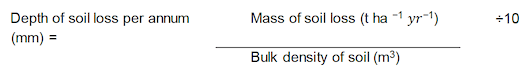
Over 20 years, the overall mass of soil loss was 340 t ha-1 . Given a bulk density of 1.25 Mg m3, the application of Equation 1 meant that the effects on crop productivity described in Table 61 were associated with a total soil depth loss of 27.2 mm. On an annual basis, assuming that the soil was eroded at a mean rate of 17 t ha-1 yr-1, the average annual reductions described in Table 61 were found to be associated with a soil depth loss of 1.36 mm yr-1. Using these data provided by Pimental et al. (1995), the yield reduction associated with each mm of soil loss was calculated by Graves et al. (2011) to be approximately 0.74%.
Appendix D. Estimated contents of soil carbon and major nutrients (from Graves et al., 2011)
Organic C content (% by weight) is provided in NSI topsoil data and is measured either by loss-on-ignition or by dichromate digestion (Table 71). Total P and K concentrations (mg kg-1) were determined by inductively coupled plasma emission spectrometry in an aqua regia digest (Table 73; Table 74). The NSI topsoil database does not contain data on N concentrations, and this was therefore estimated from the C content of the soil. Commonly found ratios of C to N in soils vary from about 8 to 1 to 15 to 1, with 11 to 1 being typical (Brady and Weil, 2008). The 11 to 1 C to N ratio was therefore used to estimate the quantity of N that would typically be in the soil (Table 72).
| Land use | C content (kg/t) | |||
|---|---|---|---|---|
| Soilscapes | ||||
| Clay | Silt | Sand | Peat | |
| Urban | 45 | 38 | 42 | 140 |
| Horticulture | 36 | 41 | 28 | 198 |
| Arable intensive | 39 | 44 | 29 | 166 |
| Arable extensive | 37 | 38 | 32 | 123 |
| Grassland improved | 49 | 40 | 47 | 104 |
| Grassland unimproved | 67 | 48 | 74 | 210 |
| Rough grassland | 63 | 53 | 56 | 141 |
| Forestry | 69 | 45 | 54 | 186 |
| Woodland | 47 | 38 | 47 | 124 |
| Wildscape | 88 | 51 | 94 | 250 |
| Land use | N content (kg/t) | |||
|---|---|---|---|---|
| Soilscapes | ||||
| Clay | Silt | Sand | Peat | |
| Urban | 4 | 3 | 4 | 13 |
| Horticulture | 3 | 4 | 3 | 18 |
| Arable intensive | 4 | 4 | 3 | 15 |
| Arable extensive | 3 | 3 | 3 | 11 |
| Grassland improved | 4 | 4 | 4 | 9 |
| Grassland unimproved | 6 | 4 | 7 | 19 |
| Rough grassland | 6 | 5 | 5 | 13 |
| Forestry | 6 | 4 | 5 | 17 |
| Woodland | 4 | 3 | 4 | 11 |
| Wildscape | 8 | 5 | 9 | 23 |
| Land use | P content (kg/t) | |||
|---|---|---|---|---|
| Soilscapes | ||||
| Clay | Silt | Sand | Peat | |
| Urban | 0.82 | 0.77 | 0.72 | 0.85 |
| Horticulture | 0.83 | 0.79 | 0.61 | 1.09 |
| Arable intensive | 0.84 | 0.83 | 0.66 | 1.06 |
| Arable extensive | 0.81 | 0.80 | 0.67 | 0.91 |
| Grassland improved | 0.86 | 0.79 | 0.69 | 0.80 |
| Grassland unimproved | 0.84 | 0.79 | 0.72 | 0.84 |
| Rough grassland | 0.82 | 0.82 | 0.71 | 0.80 |
| Forestry | 0.80 | 0.66 | 0.54 | 0.82 |
| Woodland | 0.81 | 0.71 | 0.65 | 0.78 |
| Wildscape | 0.77 | 0.73 | 0.63 | 0.74 |
| Land use | K content (kg/t) | |||
|---|---|---|---|---|
| Soilscapes | ||||
| Clay | Silt | Sand | Peat | |
| Urban | 5.07 | 4.63 | 3.71 | 3.54 |
| Horticulture | 4.88 | 4.70 | 2.42 | 2.79 |
| Arable intensive | 5.39 | 5.42 | 3.14 | 3.86 |
| Arable extensive | 5.46 | 5.18 | 3.55 | 4.13 |
| Grassland improved | 5.33 | 5.39 | 3.93 | 3.77 |
| Grassland unimproved | 5.19 | 5.27 | 3.68 | 3.01 |
| Rough grassland | 4.83 | 5.00 | 3.65 | 3.67 |
| Forestry | 5.12 | 5.18 | 2.79 | 3.31 |
| Woodland | 5.17 | 4.66 | 3.52 | 3.39 |
| Wildscape | 4.48 | 4.11 | 3.20 | 2.47 |
Contact
Email: resasadmin@gov.scot
There is a problem
Thanks for your feedback