Scottish Vacant and Derelict Land Survey 2019
Data collection undertaken to establish the extent and state of vacant and derelict land in Scotland. The data is sourced from local authorities and the Loch Lomond and Trossachs National Park Authority.
This document is part of a collection
7. Derelict Land: Levels, Location and Characteristics
7.1 This section focuses exclusively on derelict land - its levels over the past seven years and its location within Scotland. Derelict land is land which has been so damaged by development, that it is unsuitable for development for beneficial use without rehabilitation. The land must currently not be used for the purpose for which it is held or a use acceptable in the local plan. Land also qualifies as derelict if it has an un-remedied previous use which could constrain future development.
7.2 The total amount of derelict land has shown a net increase of 99 hectares (1%), from 8,767 hectares in 2013 to 8,866 hectares in 2019 (Table 6). This increase has been notably influenced by the addition of over 2,200 hectares of former surface coal mines in 2014.
7.3 Excluding derelict mineral sites, the total amount of derelict land in Scotland has shown a net decrease of 15% (1,016 hectares) since 2013 (from 6,832 hectares in 2013 to 5,816 hectares in 2019).
7.4 The change in the recorded amount of derelict land from 2013 to 2019 varies by authority. Some councils have seen large decreases - Renfrewshire had a percentage decrease of 81%. Others have seen large increases in levels of derelict land - East Ayrshire has more than five times the amount of derelict land in 2019 compared to 2013. This large increase is due to the addition of 2,217 hectares of former surface coal mines in 2014 (see Section 5).
7.5 The large percentage changes for some authorities, for example Na h-Eileanan Siar, Argyll and Bute, Clackmannanshire and Moray, are due the small base of recorded land in 2013.
7.6 The five councils recording the largest amount of derelict land in 2019 are East Ayrshire (1,736 ha), Highland (1,276 ha), North Lanarkshire (1,218 ha), North Ayrshire (1,011 ha) and Fife (600 ha). Together these councils account for two thirds (66%) of all derelict land recorded in 2019.
7.7 The largest derelict sites recorded in the 2019 survey include:
- Fearn and Fendom Airfields and the Port of Arderseir in Highland (386, 295 and 255 hectares)
- A former explosives factory in Ardeer, North Ayrshire (332 hectares)
- A former opencast coal site in Muirkirk, East Ayrshire (246 hectares)
7.8 The largest site recorded as derelict for the first time during this survey was at Turnberry Airfield in South Ayrshire (13 hectares).
| Local Authority | Total Derelict land Area (ha) | % Change 2013-20195 | ||||||
|---|---|---|---|---|---|---|---|---|
| 2013 | 2014 | 2015 | 2016 | 2017 | 2018 | 2019 | ||
| Aberdeen City | 29 | 25 | 21 | 16 | 13 | 13 | 13 | -56% |
| Aberdeenshire | 35 | 34 | 34 | 38 | 45 | 43 | 42 | 22% |
| Angus | 124 | 126 | 112 | 100 | 94 | 229 | 223 | 79% |
| Argyll and Bute4 | 9 | 8 | 37 | 37 | 37 | 38 | 38 | 345% |
| Clackmannanshire | 11 | 15 | 12 | 54 | 48 | 46 | 41 | 260% |
| Dumfries and Galloway | 483 | 482 | 455 | 457 | 301 | 301 | 294 | -39% |
| Dundee City | 14 | 18 | 16 | 16 | 14 | 17 | 14 | -5% |
| East Ayrshire | 285 | 2,493 | 2,480 | 2,386 | 2,324 | 1,736 | 1,736 | 510% |
| East Dunbartonshire | 56 | 52 | 61 | 67 | 69 | 43 | 43 | -24% |
| East Lothian | 62 | 61 | 76 | 76 | 79 | 78 | 79 | 27% |
| East Renfrewshire | 39 | 36 | 36 | 36 | 34 | 34 | 34 | -13% |
| City of Edinburgh | 112 | 111 | 96 | 96 | 91 | 88 | 87 | -22% |
| Falkirk | 89 | 101 | 108 | 163 | 210 | 208 | 194 | 119% |
| Fife | 820 | 826 | 612 | 615 | 614 | 611 | 600 | -27% |
| Glasgow City | 644 | 638 | 641 | 640 | 621 | 580 | 530 | -18% |
| Highland6 | 1,302 | 1,299 | 1,276 | 1,276 | 1,276 | 1,276 | 1,276 | -2% |
| Inverclyde | 26 | 26 | 28 | 82 | 81 | 83 | 59 | 125% |
| Loch Lomond and the Trossachs National Park4 | 25 | 25 | 25 | 25 | 25 | 6 | 6 | -75% |
| Midlothian | 254 | 205 | 189 | 182 | 108 | 108 | 100 | -61% |
| Moray | 9 | 9 | 8 | 7 | 7 | 7 | 7 | -21% |
| Na h-Eileanan Siar | 1 | 1 | 1 | 1 | 1 | * | * | -89% |
| North Ayrshire | 1,125 | 1,137 | 1,129 | 1,127 | 1,147 | 1,098 | 1,011 | -10% |
| North Lanarkshire | 1,148 | 1,142 | 1,120 | 1,086 | 1,141 | 1,204 | 1,218 | 6% |
| Orkney Islands | 39 | 39 | 39 | 39 | 39 | 32 | 32 | -19% |
| Perth and Kinross4 | 41 | 31 | 32 | 27 | 21 | 22 | 24 | -41% |
| Renfrewshire | 784 | 761 | 748 | 708 | 173 | 160 | 149 | -81% |
| Scottish Borders | 54 | 49 | 49 | 49 | 46 | 45 | 46 | -15% |
| Shetland Islands | 7 | 5 | 5 | 5 | 6 | 6 | 6 | -2% |
| South Ayrshire | 70 | 70 | 75 | 81 | 81 | 96 | 110 | 56% |
| South Lanarkshire | 356 | 345 | 340 | 296 | 306 | 296 | 291 | -18% |
| Stirling4 | 123 | 123 | 122 | 108 | 108 | 108 | 110 | -11% |
| West Dunbartonshire4 | 168 | 168 | 167 | 157 | 149 | 152 | 148 | -12% |
| West Lothian6 | 421 | 417 | 346 | 346 | 346 | 304 | 304 | -28% |
| Scotland | 8,767 | 10,877 | 10,496 | 10,399 | 9,654 | 9,070 | 8,866 | 1% |
1. Figures may not sum due to rounding.
2. See Annex D for details of council participation in different years.
3. During 2019, historical data for the years 2013-2018 were updated as a result of improved information. This included removing sites that should not have been included in previous years, adding sites that should have been included earlier and making any required changes to site size. Further information on this process is available in the Annex along with un-amended historical data for the survey years of 2000-2012.
4. From 2011 Loch Lomond and The Trossachs National Park took responsibility for surveying vacant and derelict land within the park boundaries. Prior to 2011 these sites were classified within the relevant local authority boundary.
5. Previous SVDLS bulletins have used different base years for percentage change and so these percentages should not be compared with those in previous bulletins.
6. Highland last updated their survey in 2015 so their 2019 figures have been carried over from 2015.
7. Figures do not include urban vacant sites in settlements with a population of less than 2,000. These are reported separately in the Annex.
7.9 Just over three quarters of all Scotland’s derelict sites are found within a settlement; the remaining quarter is within the countryside (Table 7). While the majority of derelict sites are located within settlements a larger area of derelict land is found outside of settlements with 5,686 hectares of derelict land, 64% of the total area, in the countryside.
7.10 North Lanarkshire has the largest number of settlement-based derelict sites with 313 recorded in 2019 and the largest amount of derelict land recorded within settlements in 2019 (830 hectares). This accounts for just over a quarter of all settlement-based derelict land.
7.11 North Lanarkshire also has the largest number of countryside-based derelict sites with 87 (388 hectares) recorded in 2019. However, the largest area of derelict land in the countryside is in East Ayrshire (1,680 hectares) which accounts for 30% of all countryside-based derelict land. This is due mainly to a small number of very large derelict former surface coal mines in East Ayrshire.
7.12 The average size of a derelict site in Scotland is 4.7 hectares. The average size of a countryside site is 12.7 hectares, with the average size of a settlement-based derelict site notably smaller at 2.2 hectares.
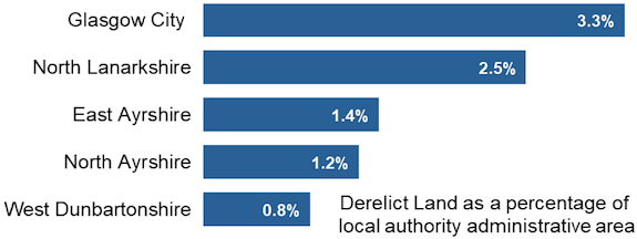
7.13 Across Scotland as a whole 0.1% of all land is derelict. Glasgow City has the largest amount of derelict land in relation to the size of its administrative area (Chart 1). The figures for all councils can be found in Annex Table 3.
Land areas were derived from the latest local authority boundaries produced by Ordnance Survey.
© Crown copyright and database right (2020). Ordnance Survey (OS Licence number 100024655).
| Local Authority | In a Settlement | In the Countryside | All Derelict Land | ||||||||||
|---|---|---|---|---|---|---|---|---|---|---|---|---|---|
| Area (ha) | % of LA's derelict land in settlements (by Area) | No of Sites | Average Site Size | % of Scottish derelict land in settlements (by Area)3 | Area (ha) | % of LA's derelict land in the Countryside (by Area) | No of Sites | Average Site Size | % of Scottish derelict land in the Countryside (by Area)4 | Area (ha) | No of Sites | Average Site Size | |
| Aberdeen City | 13 | 100 | 15 | 1 | * | - | - | - | - | - | 13 | 15 | 1 |
| Aberdeenshire | 29 | 68 | 27 | 1 | 1 | 13 | 32 | 2 | 7 | * | 42 | 29 | 1 |
| Angus | 16 | 7 | 9 | 2 | 1 | 206 | 93 | 11 | 19 | 4 | 223 | 20 | 11 |
| Argyll and Bute5 | 9 | 23 | 8 | 1 | * | 29 | 77 | 3 | 10 | 1 | 38 | 11 | 3 |
| Clackmannanshire | 5 | 13 | 9 | 1 | * | 36 | 87 | 3 | 12 | 1 | 41 | 12 | 3 |
| Dumfries and Galloway | 73 | 25 | 36 | 2 | 2 | 221 | 75 | 8 | 28 | 4 | 294 | 44 | 7 |
| Dundee City | 14 | 100 | 17 | 1 | * | - | - | - | - | - | 14 | 17 | 1 |
| East Ayrshire | 56 | 3 | 35 | 2 | 2 | 1,680 | 97 | 44 | 38 | 30 | 1,736 | 79 | 22 |
| East Dunbartonshire | 15 | 34 | 3 | 5 | * | 28 | 66 | 7 | 4 | * | 43 | 10 | 4 |
| East Lothian | 22 | 29 | 11 | 2 | 1 | 56 | 71 | 19 | 3 | 1 | 79 | 30 | 3 |
| East Renfrewshire | 32 | 95 | 21 | 2 | 1 | 2 | 5 | 1 | 2 | * | 34 | 22 | 2 |
| City of Edinburgh | 86 | 98 | 22 | 4 | 3 | 2 | 2 | 1 | 2 | * | 87 | 23 | 4 |
| Falkirk | 148 | 76 | 33 | 4 | 5 | 46 | 24 | 13 | 4 | 1 | 194 | 46 | 4 |
| Fife | 211 | 35 | 106 | 2 | 7 | 389 | 65 | 54 | 7 | 7 | 600 | 160 | 4 |
| Glasgow City | 494 | 93 | 237 | 2 | 16 | 36 | 7 | 5 | 7 | 1 | 530 | 242 | 2 |
| Highland6 | 174 | 14 | 75 | 2 | 5 | 1,102 | 86 | 28 | 39 | 19 | 1,276 | 103 | 12 |
| Inverclyde | 59 | 100 | 46 | 1 | 2 | - | - | - | - | - | 59 | 46 | 1 |
| Loch Lomond and The Trossachs National Park5 | 3 | 43 | 6 | * | * | 4 | 57 | 1 | 4 | * | 6 | 7 | 1 |
| Midlothian | 28 | 29 | 15 | 2 | 1 | 71 | 71 | 21 | 3 | 1 | 100 | 36 | 3 |
| Moray | 7 | 100 | 7 | 1 | * | - | - | - | - | - | 7 | 7 | 1 |
| Na h-Eileanan Siar | * | 100 | 1 | * | * | - | - | - | - | - | * | 1 | * |
| North Ayrshire | 318 | 31 | 80 | 4 | 10 | 693 | 69 | 29 | 24 | 12 | 1,011 | 109 | 9 |
| North Lanarkshire | 830 | 68 | 313 | 3 | 26 | 388 | 32 | 87 | 4 | 7 | 1,218 | 400 | 3 |
| Orkney Islands | - | - | - | - | - | 32 | 100 | 1 | 32 | 1 | 32 | 1 | 32 |
| Perth and Kinross5 | 11 | 44 | 17 | 1 | * | 14 | 56 | 28 | * | * | 24 | 45 | 1 |
| Renfrewshire | 43 | 29 | 23 | 2 | 1 | 106 | 71 | 2 | 53 | 2 | 149 | 25 | 6 |
| Scottish Borders | 31 | 69 | 50 | 1 | 1 | 14 | 31 | 8 | 2 | * | 46 | 58 | 1 |
| Shetland Islands | 1 | 14 | 1 | 1 | * | 6 | 86 | 5 | 1 | * | 6 | 6 | 1 |
| South Ayrshire | 90 | 82 | 54 | 2 | 3 | 19 | 18 | 7 | 3 | * | 110 | 61 | 2 |
| South Lanarkshire | 140 | 48 | 85 | 2 | 4 | 151 | 52 | 23 | 7 | 3 | 291 | 108 | 3 |
| Stirling5 | 7 | 6 | 6 | 1 | * | 103 | 94 | 8 | 13 | 2 | 110 | 14 | 8 |
| West Dunbartonshire5 | 148 | 100 | 55 | 3 | 5 | * | * | 1 | * | * | 148 | 56 | 3 |
| West Lothian6 | 67 | 22 | 15 | 4 | 2 | 237 | 78 | 28 | 8 | 4 | 304 | 43 | 7 |
| Scotland | 3,179 | 36 | 1,438 | 2 | 100 | 5,686 | 64 | 448 | 13 | 100 | 8,866 | 1,886 | 5 |
1. Figures may not sum due to rounding.
2. Settlements as defined by Local Authorities in their latest council approved local plans.
3. As a percentage of total derelict land within a settlement in Scotland.
4. As a percentage of total derelict land within the countryside in Scotland.
5. From 2011 Loch Lomond and The Trossachs National Park took responsibility for surveying vacant and derelict land within the park boundaries. Prior to 2011 these sites were classified within the relevant local authority boundary.
6. Highland has not updated their survey since 2015 so their 2019 figures have been carried over from 2015.
7.14 Where derelict characteristics are recorded the most common characteristic in terms of the number of sites is the remains of buildings, with 656 sites listed with this as a single characteristic. However, this only accounts for 10% of the total area of characterised derelict land. The largest area of characterised derelict land is listed as having a mixture of possible left over chemicals/substances and rubble, stone deposits and other material - 2,059 hectares (27% of total area) across 117 sites. A further 21% of the total area (1,582 hectares and 183 sites) is characterised by building remains and possible left over chemicals/substances. It should be noted that there is potential for overlap between these categories, so the results should be treated with some caution.
| Derelict Characteristics | Area (ha) | % of Derelict Land with known characteristics (by Area)2 | No. of Sites |
|---|---|---|---|
| Building remains | 777 | 10 | 656 |
| Possible left over chemicals/substances | 878 | 12 | 227 |
| Abandoned physical material (stone deposits, rubble etc) | 513 | 7 | 161 |
| Building remains and possible left over chemicals/substances | 1,582 | 21 | 183 |
| Building remains and abandoned physical material (stone deposits, rubble etc) | 440 | 6 | 140 |
| Possible left over chemicals/substances and rubble, stone deposits and other material | 2,059 | 27 | 117 |
| Building remains, possible left over chemicals/substances and abandoned physical material (stone deposits, rubble etc) | 1,345 | 18 | 75 |
| Total Derelict Land with known characteristics | 7,593 | 100 | 1,559 |
| Unknown2 | 1,273 | 327 | |
| Total Derelict Land | 8,866 | 1,886 |
1. Figures may not sum due to rounding.
2. Unknown values are excluded from the calculation of percentages.
Contact
Email: planstats@gov.scot
There is a problem
Thanks for your feedback