Scottish Index of Multiple Deprivation: 2009 General Report
Scottish Index of Multiple Deprivation 2009: General Report
12. Local Authority Analysis
12.1 The following pages contain analysis by Local Authority in the form of maps and charts. The data shown on the charts and maps is all taken from the SIMD 2009 and its constituent domains. Some include comparisons with SIMD 2004 and SIMD 2006. These pages give a feel for the sort of analysis possible using the SIMD and have been selected for this purpose and to identify some key findings for each area. Further charts, maps and analysis for each Local Authority are available on the SIMD website and through the interactive mapping website.
12.2 The charts on the following pages consist of bar charts, box plots and bar code charts. The latter two are explained below.
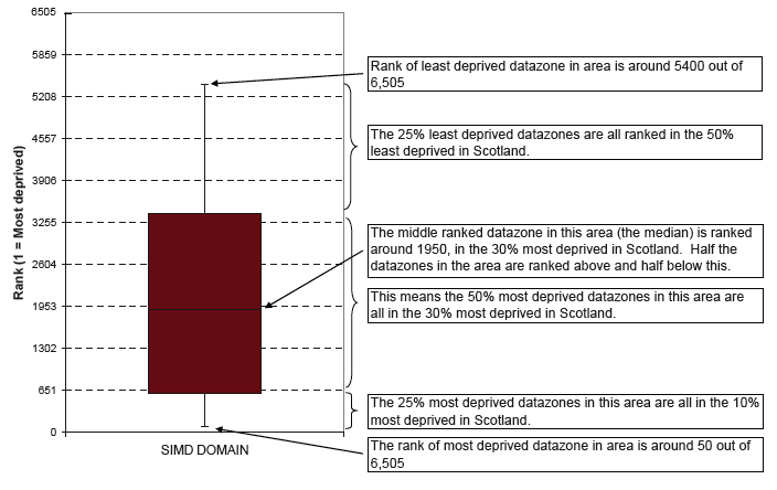
Box Plots
12.3 Box plots show the minimum and maximum value for an area on a particular indicator eg the highest and lowest ranked datazone as lines. The box in the middle of the chart shows the middle 50% of values and the middle value, ie a quarter of datazones will lie below the box and a quarter above.
Bar code charts
12.4 Bar code charts show how the levels of deprivation in a Local Authority compared with the rest of Scotland. Each bar on the bar code represents a datazone and is positioned according to its deprivation rank, ie the more deprived a datazone is, the further to the left it will be positioned. A concentration of lines close together shows as a black block, if one appears at the left hand end of the scale it shows a concentration of deprived areas. A concentration at the right hand end shows a concentration of areas at the least deprived end of the distribution (as in the example below).
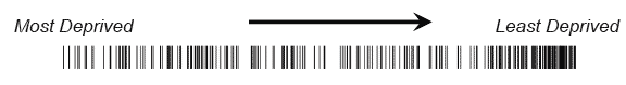
12.5 Some Local Authorities will have no concentrations of lines as they will have a small number of datazones spread across the scale. Larger Local Authorities may have several concentrations along the distribution.
Local Authority Bar code charts
Each bar represents a single datazone placed on a scale from most deprived to least deprived according to the SIMD 2009 rank. Concentrations of datazones in a Local Authority with similar ranks show up as dark blocks, for example at the most deprived end of the scale in Glasgow.

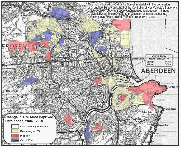
Aberdeen City
The 25% most deprived datazones in Aberdeen City all rank in the 30% most deprived nationally. Health, Education, Housing and Access are driving this trend with the median and 25% most deprived datazones below that for the overall SIMD. In SIMD 2006 Aberdeen had 43 datazones in the 15% most health deprived and it has 44 in SIMD 2009. Comparing this map to one for SIMD 2006 shows the datazones moving out to mainly be in the 10-15% band for SIMD 2006 and those moving in have come from the 15-20% band.
Box plot: summary of local authority domain ranks in SIMD 2009

Map: change in 15% most deprived datazones on the health domain in SIMD 2009
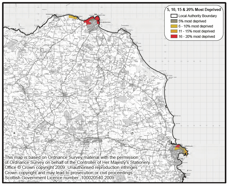
Aberdeenshire
Aberdeenshire has most of its datazones in the least deprived in terms of SIMD ranks across all 3 years. The percentage of datazones in decile two has fallen since SIMD 2006 but the percentage in decile three and four has risen. The most deprived datazones on the education domain are clustered in the urban areas of Fraserburgh and Peterhead with both areas having datazones in the 10% most deprived in Scotland.
Decile graph: distribution of local authority datazone ranks in each decile in the SIMD

Map: most deprived datazones on the education domain in SIMD 2009
Angus
Angus has seen an increase in the percentage of datazones in the 10% most deprived since SIMD 2004. However the distribution of datazones has remained similar overtime. The map shows that the majority of income deprived datazones in Angus are in Arbroath with datazones in the 5 and 10% most deprived on the income domain. A small number of income deprived datazones are found in Forfar and Brechin.
Decile graph: summary of local authority domain ranks in SIMD 2009

Map: most deprived datazones on the income domain in SIMD 200

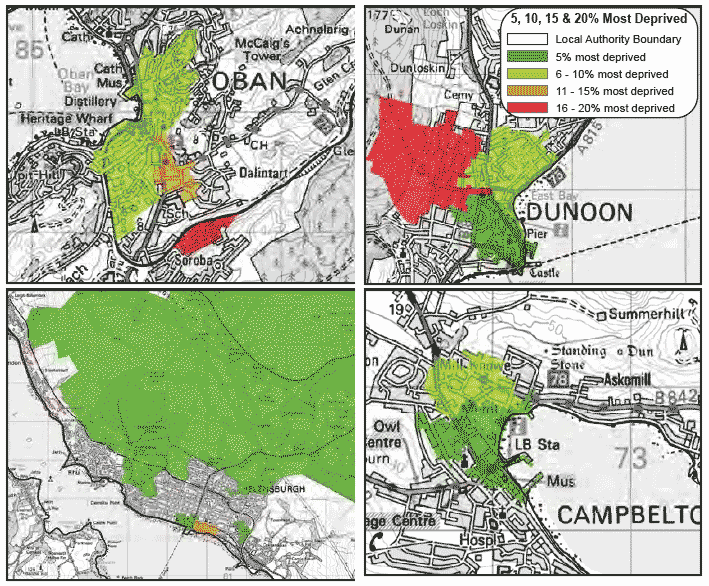
Argyll & Bute
Three quarters of Argyll & Bute datazones are out with the 30% most deprived on the SIMD 2009, however there are still deprived datazones in the Local Authority. Over half of the datazones in Argyll & Bute are in the 15% most deprived on the access domain. Housing is also an issue though this is reflecting census data. The most deprived areas in the SIMD 2009 crime domain are predominantly grouped together in urban, more densely populated areas. The large rural datazone on the edge of Helensburgh includes the main route along Loch Lomond and several tourist and holiday destinations which will mean large influxes of people throughout the year compared to the resident population.
Box plot: summary of local authority domain ranks in SIMD 2009

Map: most deprived datazones on the crime domain in SIMD 2009
These maps are based on Ordnance Survey material with the permission of Ordnance Survey on behalf of the Controller of Her Majesty's Stationery Office © Crown copyright 2009. Unauthorised reproduction infringes Crown copyright and may lead to prosecution or civil proceedings. Scottish Government Licence number: 100020540 2009.
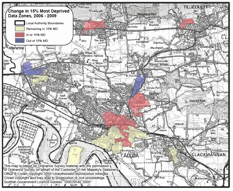
Clackmannanshire
Clackmannanshire's distribution of datazone ranks tended to follow a similar pattern in each of the SIMD updates. That is, peaks at the most deprived end and around deciles 5, 6 and 7. The increase in datazones in decile one has been reversed in the SIMD 2009 update though there has been an increase in decile 2. The map shows that deprivation in relation to crime is mostly in Alloa. The number of datazones in the 15% most deprived on the crime domain has risen from 7 to 13 with several of those moving in ranked in the 15-20% most deprived on SIMD 2006.
Decile graph: distribution of local authority datazone ranks in each decile in the SIMD

Map: change in 15% most deprived datazones on the crime domain in SIMD 2009
Dumfries & Galloway
The domains of the SIMD follow different patterns to the overall SIMD within Dumfries & Galloway. In the health and housing domains, three quarters of datazones are out with the 40% most deprived. In the access domain, half the datazones fall within the 30% most deprived. The map shows the SIMD 2009 crime domain, the most deprived datazones are found in Dumfries and Annan, apart from one large rural datazone. This datazone includes the land used for a large music festival which is likely to have impacted on the number of crimes recorded in this datazone, though only the resident population is used to calculate the crime rate and rank.
Box plot: summary of local authority domain ranks in SIMD 2009

Map: most deprived datazones on the crime domain in SIMD 2009
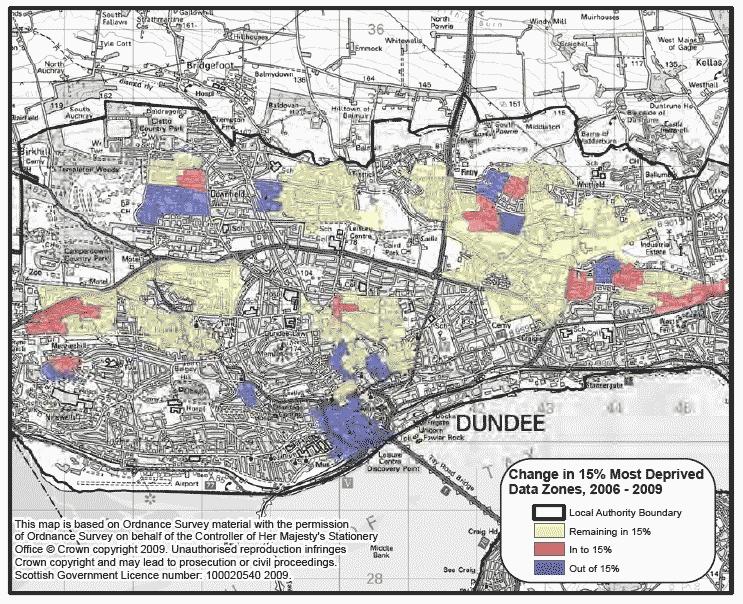
Dundee City
On the overall SIMD 2009, and on the individual domains (aside from access and crime), Dundee City's datazone ranks are concentrated more towards the most deprived. On each of these domains including the overall SIMD 2009, half of its datazones have a rank of around 2,000 or less. The income, employment and housing domains have a median and 25% most deprived lower than that for the overall SIMD. The map shows that in terms of the education domain, movement of datazones into and out of the most deprived tend to happen on the boundaries of datazones in the 15% most deprived.
Box plot: summary of local authority domain ranks in SIMD 2009

Map: change in 15% most deprived datazones on the education domain in SIMD 2009
East Ayrshire
Over the SIMDs, the distribution of datazones for each decile of deprivation has remained similar, with the highest percentage of datazones in deciles one to four. The map shows that datazones in the 20% most deprived in Scotland are typically smaller in size and are grouped together in small concentrated areas with the largest concentration around Kilmarnock. The larger, more rural datazones are generally found to be in the 40-60% and 60-80% bands.
Decile graph: distribution of local authority datazone ranks in each decile in the SIMD

Map: levels of deprivation in the overall SIMD 2009 by National quintiles (0-20% band of deprivation shows 20% most deprived datazones in Scotland)

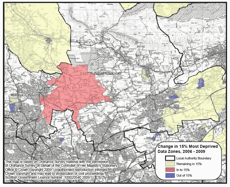
East Dunbartonshire
The majority of the datazones in East Dunbartonshire are at the least deprived end of the SIMD. In the employment and health domains, the 25% most deprived and medians are below that for the overall SIMD. The access domain also identifies deprivation in this area with a quarter of datazones falling in the 30% most deprived. The map shows the datazones that have moved in or out of the 15% most deprived on the access domain since SIMD 2009, overall the Local Authority has seen a fall from ten datazones to eight.
Box plot: summary of local authority domain ranks in SIMD 2009

Map: change in 15% most deprived datazones on the access domain in SIMD 2009
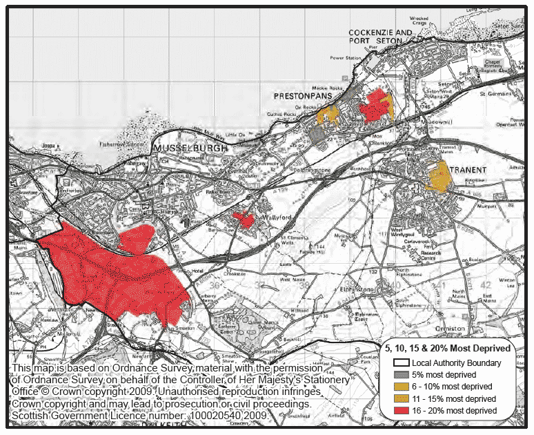
East Lothian
The overall SIMD ranks in East Lothian are similarly distributed for SIMD 2004, 2006, and 2009. However, there has been a slight shift in the distribution towards the most deprived with a rise since SIMD 2004 in the number of datazones in deciles 2 and 3. The map shows that the most deprived datazones on the education domain are in the Prestonpans and Tranent, though there are also datazones in the 15-20% band.
Decile graph: distribution of local authority datazone ranks in each decile in the SIMD

Map: most deprived datazones on the education domain in SIMD 2009
East Renfrewshire
For the overall SIMD, this Local Authority has mostly least deprived datazones, although it still contains datazones in the most deprived in Scotland. In terms of individual domains, the distribution of the education domain leans more towards the least deprived. The map shows the health domain for East Renfrewshire, there was a relatively small movement of datazones from SIMD 2006 to SIMD 2009 into and out of the 15% most health deprived. Those moving out were in the 10-15% band and those moving in were in the 15-20% band on SIMD 2006. The rest of the Local Authority does not appear in the 15% most health deprived.
Box plot: summary of local authority domain ranks in SIMD 2009

Map: change in 15% most deprived datazones on the health domain in SIMD 2009
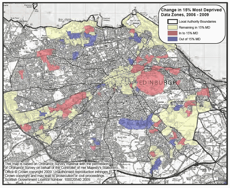
Edinburgh, City of
Edinburgh has seen little change in the distribution of datazones across the SIMD deciles between SIMD 2004 and SIMD 2009. Over 30% of Edinburgh's datazones are in the least deprived SIMD decile. The map shows that there has been some movement in the datazones highlighted in the 15% most deprived on the crime domain of SIMD 2009. Edinburgh has seen an increase from 77 datazones in the 15% most deprived on the crime domain of SIMD 2006 to 100 on SIMD 2009.
Decile graph: distribution of local authority datazone ranks in each decile in the SIMD

Map: change in 15% most deprived datazones on the crime domain in SIMD 2009
Eilean Siar
Eilean Siar has no datazones in the 15% most deprived in terms of overall SIMD 2009. However, on the access domain, it has most of its datazones in the 15% most deprived, with most having ranks of below 500. The 25% most health deprived datazones in the Local Authority are also low relative to other domains. Locally, the 20% most deprived datazones on the overall SIMD 2009 are not concentrated anywhere in Eilean Siar. Smaller deprived datazones in built up areas such as in Stornoway will not show up due to the scale of the map.
Box plot: summary of local authority domain ranks in SIMD 2009

Map: levels of deprivation in the overall SIMD 2009 by Local Authority quintiles (0-20% band of deprivation shows 20% most deprived datazones in local authority area)

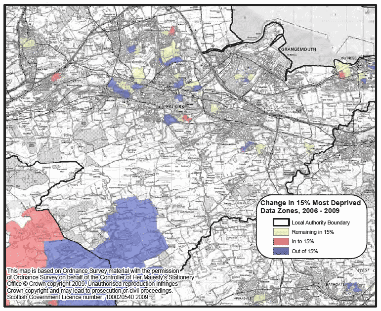
Falkirk
A quarter of datazones in Falkirk are in the 30% most deprived. The employment domain and education domain have medians and the 25% most deprived lower than that for the overall SIMD. Falkirk has seen a fall in the number of datazones in the 15% most deprived on the education domain from 39 datazones to 28, though they are still spread across the Local Authority area.
Box plot: summary of local authority domain ranks in SIMD 2009

Map: change in 15% most deprived datazones on the education domain in SIMD 2009
Fife
Datazones in Fife are equally distributed among the most to the least deprived in terms of SIMD 2009 rankings, with fewer datazones in decile 1, the 10% most deprived, though the numbers in the most deprived decile has been increasing on each update to the SIMD. The map shows the SIMD 2009 access domain for Fife. Fife has seen a fall in the number of it's datazones in the 15% most access deprived from 67 datazones to 54, around 12% of Fife's datazones. These are spread across the Local Authority area.
Decile graph: distribution of local authority datazone ranks in each decile in the SIMD

Map: most deprived datazones on the access domain in SIMD 2009
Glasgow City
In each SIMD, Glasgow has seen a gradual improvement in its SIMD rankings with a concentration of its most deprived datazones shifting towards the less deprived end of the scale. In SIMD 2004, Glasgow had 374 datazones in the 15% most deprived. In SIMD 2006 this had fallen to 330 and in SIMD 2009 this has fallen further to 302. The number of datazones in the most deprived 5% has also fallen from 226 to 169 to 158, from 33% to 23% of the Local Authority.
Despite these decreases, the map shows that deprived datazones are spread across the city of Glasgow, though when compared with a similar map for SIMD 2006, the reduction of datazones in the 5% most deprived is obvious.
Barcode charts: distribution of local authority SIMD 2009 ranks

Map: most deprived datazones in the overall SIMD 2009

Highland
The overall distribution of datazones in Highland across the overall SIMD has changed little over the three versions of the index, however Highland has seen an increase in the proportion of datazones in the first 2 deciles. The map shows the deprived datazones across the Local Authority on the overall SIMD by 20% band. Due to the scale of the map, the datazones in built up areas such as Inverness and Fort William do not show up, however it does highlight several datazones in the 20% most deprived in Highland in more rural parts of the Local Authority.
Decile graph: distribution of local authority datazone ranks in each decile in the SIMD

Map: levels of deprivation in the overall SIMD 2009 by Local Authority quintiles (0-20% band of deprivation shows 20% most deprived datazones in local authority area)

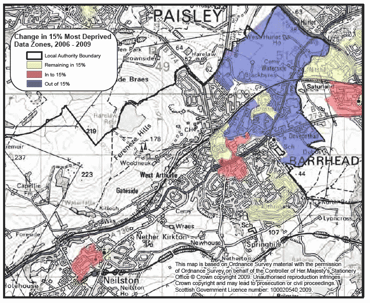
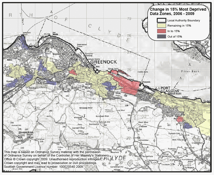
Inverclyde
Around 45% of datazones in Inverclyde are ranked in Scotland's 20% most deprived datazones in SIMD 2009. Inverclyde has seen an increase in the proportion of it's datazones in the 10% most deprived and a decrease in datazones in the 10-20% most deprived over the three versions of the SIMD. The map shows that many of the datazones in the 15% most deprived on the employment domain in SIMD 2006 remained in the most deprived in SIMD 2009. Those datazones that moved out were mainly in the 10-15% band in SIMD 2006. Those moving in were in the 15-20% band of the employment domain.
Decile graph: distribution of local authority datazone ranks in each decile in the SIMD

Map: change in 15% most deprived datazones on the employment domain in SIMD 2009
Midlothian
In the overall ranks for SIMD 2009, only a small percentage of Midlothian's datazones are in decile 1, the most deprived decile. There is a fall in the number of datazones in the second decile and an increase in the third decile since SIMD 2006. Midlothian has seen a decrease from 10 to 8 datazones in the 20% most deprived between SIMD 2006 and SIMD 2009. These are shown on the map below as three distinct concentrations.
Decile graph: distribution of local authority datazone ranks in each decile in the SIMD

Map: levels of deprivation in the overall SIMD 2009 by National quintiles (0-20% band of deprivation shows 20% most deprived datazones in Scotland)

Moray
More than half the datazones in Moray are in the 50% least deprived on the overall SIMD. The income, employment, education, access and crime domains all have medians and 25% most deprived lower than the overall SIMD. The map shows deprivation quintiles for SIMD 2009 for the Local Authority. The majority of datazones in the 20% most deprived are around Forres and Elgin, though there are other datazones in towns across the Local Authority area, for example around Buckie.
Box plot: summary of local authority domain ranks in SIMD 2009

Map: levels of deprivation in the overall SIMD 2009 by Local Authority quintiles (0-20% band of deprivation shows 20% most deprived datazones in local authority area)

North Ayrshire
North Ayrshire has seen an increase in the number of it's datazones in the 15% most deprived. In SIMD 2004 and SIMD 2006 33 datazones fell in the 15% most deprived nationally. This has increased to 43 on SIMD 2009. North Ayrshire has also seen an increase in the number of datazones in the 5 and 10% most deprived. The number in the 5% most deprived has gone from 6 to 10 and the number in the 10% most deprived from 16 to 26.
The map shows the most deprived datazones on SIMD 2009. In North Ayrshire, the datazones in the 10% most deprived are concentrated in the built up areas of Kilwinning, Irvine, and along the coast in Stevenson, Saltcoats and Ardrossan. There are deprived datazones out with these areas but these are mostly in the 10-15% or the 16-20% band.
Barcode charts: distribution of local authority SIMD 2009 ranks

Map: most deprived datazones in the overall SIMD 2009

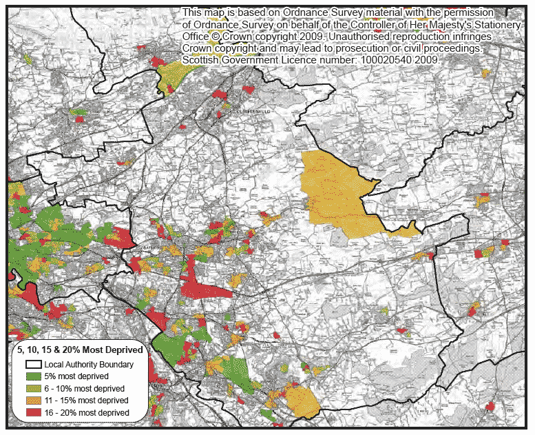
North Lanarkshire
Throughout the various updates of the SIMD, there has been a small increase in the most deprived decile and a decrease in the percentage of datazones in decile two. The overall distribution has not changed though, with a peak in deciles 2 and 3. The map shows the employment domain for SIMD 2009. The largest concentrations of datazones in the most deprived 10% are in Airdrie, Coatbridge, Motherwell and Wishaw, though datazones in the 15% most deprived are spread across the Local Authority.
Decile graph: distribution of local authority datazone ranks in each decile in the SIMD

Map: most deprived datazones on the employment domain in SIMD 2009
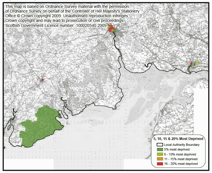
Orkney Islands
SIMD Crime is particularly low with 75% of datazones having a rank in the 25% least deprived in Scotland on the domain. The housing and access domains show levels of deprivation higher than that for the overall SIMD. The map shows deprivation quintiles within Orkney for SIMD 2009. Generally, datazones on the islands furthest away from the mainland are in the 20% most deprived datazones within the Local Authority in SIMD 2009. The 20% least deprived datazones within Orkney Local Authority in SIMD 2009 are found around Kirkwall.
Box plot: summary of local authority domain ranks in SIMD 2009

Map: levels of deprivation in the overall SIMD 2009 by Local Authority quintiles (0-20% band of deprivation shows 20% most deprived datazones in local authority area)

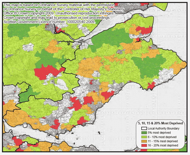
Perth & Kinross
75% of datazones in Perth & Kinross are in the 50% least deprived and similar patterns are seen on all the domains except for the access domain. Half of datazones are ranked in the 40% most access deprived with 25% in the 15% most deprived. The map shows the overall SIMD by 20% bands within the local authority. The most deprived areas within Perth & Kinross are found in Perth and Crieff with a small number of datazones in Blairgowrie. The larger rural datazones show as being the least deprived.
Box plot: summary of local authority domain ranks in SIMD 2009

Map: levels of deprivation in the overall SIMD 2009 by Local Authority quintiles (0-20% band of deprivation shows 20% most deprived datazones in local authority area)

Renfrewshire
Over a quarter of datazones in Renfrewshire are in Scotland's 20% most deprived datazones. Renfrewshire has seen an increase in the proportion of it's datazones in the 10% most deprived in SIMD 2009 and a decrease in the percentage in decile two. The map shows levels of income deprivation in the Local Authority. Datazones moving into the 15% most deprived were mostly in the 15-20% most deprived on SIMD 2006, so the inclusion of tax credit data in this domain has not identified completely new areas.
Decile graph: distribution of local authority datazone ranks in each decile in the SIMD

Map: change in 15% most deprived datazones on the income domain in SIMD 2009

Scottish Borders
Generally, the spreads of SIMD ranks in the Scottish Borders across all the domains are rather similar. On the overall SIMD, the 25% most deprived datazones in the local authority are ranked around 3,000 or less. In the access domain, 50% of datazones are ranked less than 3,000. The map shows levels of deprivation in the health domain on SIMD 2009. There are concentrations of health deprivation in the 10% most deprived in the Galashiels and Langlee area and around Hawick, with smaller areas of less concentrated deprivation in other towns.
Box plot: summary of local authority domain ranks in SIMD 2009

Map: most deprived datazones on the health domain in SIMD 2009

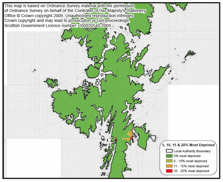
Shetland Islands
In SIMD 2004, Shetland Islands had a relatively small spread of ranks with datazones found only in deciles 5 to 9. Through SIMD 2006 and into SIMD 2009, there has been a shift in distribution towards the most deprived with datazones now also found in decile 4, and less so in deciles 8 and 9. Nearly all of the Shetland Islands are in the 5% most deprived on the access domain. The exceptions are datazones nearer Lerwick and Scalloway, which are in the 11-15% band or the 16-20% band of access deprivation. Those in Lerwick itself are not access deprived.
Decile graph: distribution of local authority datazone ranks in each decile in the SIMD

Map: most deprived datazones on the access domain in SIMD 2009
South Ayrshire
Since SIMD 2004, South Ayrshire has seen an increase in the local share of the 10% and 20% most deprived datazones in Scotland, though the overall pattern across the deciles has changed little. On the income domain, datazones in the 15% most deprived remain largely the same from SIMD 2006 to SIMD 2009, the Local Authority had 14 in the 15% most deprived on SIMD 2006 and has 16 on SIMD 2009. Most of the income deprived datazones are in and around Ayr as shown on the map. The datazones that have moved out were in the 10-15% on SIMD 2006 and those that moved in were in the 15-20% band.
Decile graph: distribution of local authority datazone ranks in each decile in the SIMD

Map: change in 15% most deprived datazones on the income domain in SIMD 2009

South Lanarkshire
South Lanarkshire has a fairly even spread of datazones across all the SIMD deciles. Since SIMD 2004, fewer datazones are found in deciles 1 and there has been a slight increase in the percentage of datazones in decile 2 since SIMD 2006. The map shows the most deprived datazones on the overall SIMD 2009. The largest concentration of deprived datazones is around Hamilton, but there are also deprived datazones spread across the Local Authority Area. South Lanarkshire has 58 datazones in the 15% most deprived on SIMD 2009.
Decile graph: distribution of local authority datazone ranks in each decile in the SIMD

Map: most deprived datazones in the overall SIMD 2009

Stirling
Datazones in Stirling are more concentrated at the least deprived end of the distribution on the overall SIMD. However the Local Authority contains datazones ranging from among the most deprived to amongst the least deprived in Scotland on the overall SIMD and the Income and Employment domains. The map shows the datazones in Stirling in the 15% most deprived on the overall SIMD 2009, which remain largely the same as in SIMD 2006 with these datazones generally clustered around the Raploch area. One datazone has moved out of the 15% most deprived since 2006 with another one moving in at Cowie.
Box plot: summary of local authority domain ranks in SIMD 2009

Map: change in 15% most deprived datazones in the overall SIMD 2009

West Dunbartonshire
The chart indicates that half the datazones in West Dunbartonshire are ranked 2000 or less in the overall SIMD with similar patterns showing in the income, employment, health and crime domains. The 25% most income and employment deprived datazones in the Local Authority fall in the 15% most deprived in Scotland. The map shows the most income deprived datazones in SIMD 2009, these are concentrated in the South East and the West of the Local Authority area, with those in the South East bordering deprived datazones in other Local Authorities. The Local Authority has seen a fall from 36 to 32 datazones in the 15% most income deprived between SIMD 2006 and SIMD 2009.
Box plot: summary of local authority domain ranks in SIMD 2009

Map: most deprived datazones on the income domain in SIMD 2009

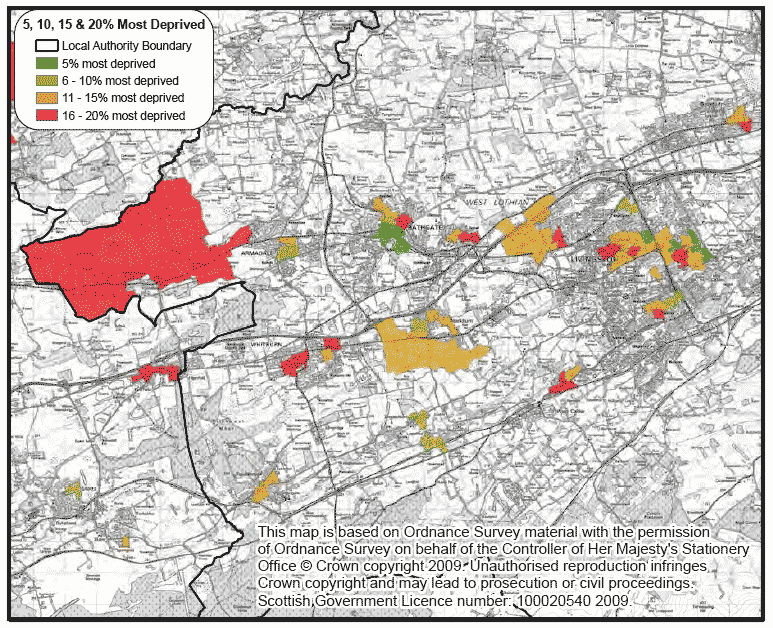
West Lothian
A relatively small percentage of West Lothian's datazones are found in the most deprived decile in terms of SIMD 2009 overall rank, though this percentage has increased with each update to the SIMD. The percentage of datazones in the second decile has also increased. The map shows the most health deprived datazones in West Lothian. There is a concentration of deprived datazones in Livingston but there are also health deprived datazones spread across the Local Authority area.
Decile graph: distribution of local authority datazone ranks in each decile in the SIMD

Map: most deprived datazones on the health domain in SIMD 2009
There is a problem
Thanks for your feedback