Developing a method to estimate the costs of soil erosion in high-risk Scottish catchments: final report
Report from a project which developed and used an ecosystem service framework approach to estimate the costs of soil erosion in Scotland, for five study catchments.
6. Applying the model to the case study catchments and national scale
We have updated data going into the economic costing model, including typical crop yields for Scotland (for a number of years); prices of crops (and hence impact of yield penalties due to soil erosion); costs of fertilisers; Gross Margins; forestry model (coniferous v. broadleaved); carbon values; soil nutrient values; GDP inflators; non market costs e.g. carbon sequestration etc.
6.1. Loss of crop yields through soil erosion
Typical yields for each crop in Scotland were taken from the Scottish Farm Management Handbook (2018/19) https://www.fas.scot/downloads/farm-management-handbook-2018-19 (SAC Consulting, 2018). For example, winter wheat has an indicative yield in Scotland of between 4.5 - 8.5 t ha yr.
Using Pimentel’s equation (Pimentel et al., 1995) to calculate yield penalties due to soil erosion (the rates of erosion should reflect the soil and crop type to some extent), relative to typical yield can be used to calculate costs of yield penalties.
6.2. Losses of nutrients and carbon
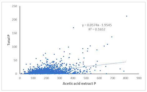
Soil properties are needed in the economic model. Bulk density (BD) is used to convert the estimated erosion rates into a loss of soil depth, which is associated with yield losses (Pimentel, 1995). Soil nutrients (nitrogen (N), phosphorus (P), potassium (K) and carbon (C)) are eroded with soil particles, so the costs of replacing them have to be estimated. The values used were spatially weighted averages calculated from the SSKIB dataset for each broad land use that occurred within the four Soil Erosion Risk Classes (L, M, H, and organo-mineral and peat soils) (Appendix 3; Appendix 4; Appendix 5; Appendix 6; Appendix 7).
6.3. Land use allocations in the selected case study catchments
The current methodology uses land use to determine the soil erosion rate, modified by Erosion Risk Class to determine the probability of that erosion rate occurring in any given year / on any given field. Soil erosion rates and probabilities for urban areas were excluded from the analysis, as these are likely to be low, due to the high proportion of sealed surfaces.
Also, data on this for Scotland was unavailable. Land use is also used to indicate current levels of soil nutrients (assuming more intensive land uses have higher levels of soil nutrients than the extensive land uses e.g. horticulture versus moorland). Production outputs (e.g. crop yields) are also linked to land use. For example, in grassland systems, it is assumed that ‘Improved Grassland’ is the most productive and intensively managed (e.g. around 8-10 t ha1 yr-1), ‘Unimproved Grassland’ is less productive and intensively managed (e.g. around 5-7 t ha-1 yr-1), and ‘Rough Grazing’ is low yielding with very low inputs (e.g. around 2-4 t ha-1 yr1). This land use category includes natural or semi-natural vegetation so it could include heather moorland, for example, whereas rough grass is just semi natural (unimproved) grass such as Molinia or Nardus or bent species. Thus accurate information on the spatial distribution of land use (and how it coincides with Erosion Risk Class) in the 5 case study catchments and for the whole of Scotland is needed as input to the economic model.
Integrated Administration and Control System (IACS) data is accurate and of high resolution (i.e. field by field). It was used to give annual snapshots of agricultural land use at the field level, allowing for high resolution spatio-temporal land use change studies at the national scale. It identifies arable, grassland and horticulture, but not forestry, woodland, wildscape or moorland. The detailed IACS land use classes then had to be linked to the crops already embedded in the economic model (and to the erosion rates assigned to each of these land uses).
Appendix 8 shows how the IACS crops found in Scotland were assigned a category relating to a) soil erosion rate (i.e. what broad land use category did the crops belong to) and b) the economic model’s range of crop types.
The National Forest Inventory (NFI) of Scotland was used to identify woodlands and forests. Where IACS or NFI data was not available, LCM 2007 was used to assign land use to the remaining areas. It is recognised that LCM 2015 would have given more up to date data but was not available to the project team within the timescales of the project.
These datasets (IACS, LCM 2007 and NFI) were combined to estimate the % of each land use in each of the five catchments. Maps of land use and Erosion Risk Class for each case study catchment were produced (Figure 4, Figure 5 and Figure 6) and the proportion of the catchment in each combination was calculated.
6.3.1. Crop rotations within arable land
Within the arable areas, the cropping patterns are needed to assign the area under each crop in any particular year. The economic model will predict yields for each of these crops. The classification of IACS classes observed into the crop types incorporated into the economic model is shown in Appendix 8. Given the broad range of crops grown under arable, some assumptions and simplifications had to be made. Set aside and fallow were assumed to be part of an ‘Extensive Arable’ rotation.
Distribution of crops over space in any one year is used as an analogy for time (i.e. ‘pseudorotation’). It was assumed that the spatial / temporal distribution of crops within arable areas would be similar in all catchments (and for the national scale). Field margins were not identified as a separate land use within arable areas.
6.3.2. Farm infrastructure
It was decided to exclude areas of farm infrastructure, such as farm buildings, yards, tracks and roads from the subsequent analyses. These can take up a proportion of the land and will have much lower soil erosion rates than the surrounding farmland, as they are often sealed by concrete, tarmac and hard standings etc.. The area involved was assumed to vary with land use, but not Erosion Risk Class (Table 14). The Countryside Information System (CIS) data was used to estimate these areas. It was assumed that these proportions would be the same for all agricultural land at the catchment and national scale.
| Land use | Proportion of land as infrastructure (%) | |||
|---|---|---|---|---|
| Erosion Risk Class | ||||
| Low | Moderate | High | Organo-mineral soils and peats |
|
| Horticulture | 15% | 15% | 15% | 15% |
| Arable intensive | 15% | 15% | 15% | 15% |
| Arable extensive | 15% | 15% | 15% | 15% |
| Grassland improved | 10% | 10% | 10% | 10% |
| Grassland unimproved | 10% | 10% | 10% | 10% |
| Rough grassland | 2% | 2% | 2% | 2% |
| Forestry | 2% | 2% | 2% | 2% |
| Woodland | - | - | - | - |
| Wildscape | - | - | - | - |
6.4. Calculating annual on-site costs
6.4.1. Erosion induced productivity loss
The effect of soil erosion on crop yields is frequently given in relation to a change in soil depth (Lal, 1998; Pimentel et al., 1995). Observed reductions show wide variation, depending on the crop rooting trait (some crops are deeper rooted than others), nutrient storage and availability, water holding capacity, soil profile characteristics, the crop grown, existing soil and crop management, and the microclimate (Lal, 1998; Pimentel et al., 1995). It could be seen that there is also a loss of opportunity in which crops can continue to grow in eroded (i.e. shallower) soils. This may require change in crop type and even land use. Since erosion induced yield declines are of considerable importance, especially in low input agriculture, tools such as EPIC (Williams, Renard and Dyke, 1983) have been developed to examine long-term effects of various components of soil erosion on crop production. Here, a simplified approach was developed, using the relationships developed by Pimentel et al. (1995). Based on a variety of measured data, Pimentel et al. (1995) found that crop yields declined by 20% over a period of 20 years (Table 15).
| Yield penalty (%) | |||
|---|---|---|---|
| Parameter associated with soil erosion | 20 year total | Average annual | per mm soil loss |
| Water runoff | 7 | 0.35 | 0.3 |
| Nitrogen loss Phosphorus loss Potassium loss |
8 | 0.4 | 0.3 |
| Soil depth loss | 7 | 0.35 | 0.3 |
| Organic matter loss | 4 | 0.2 | 0.1 |
| Water holding capacity loss | 2 | 0.1 | 0.1 |
| Soil biota loss | 1 | 0.05 | 0.0 |
| Total on-site losses | 20 | 1 | 0.74 |
The following example can illustrate the approach. Assuming soil was eroded at a mean rate of 17 t ha-1 yr-1 and the bulk density was 1.25 Mg/m3 , the annual loss of soil depth would be estimated to be 1.36 mm yr-1 using Equation 5. This therefore equated to a yield loss of 0.74% per mm of soil loss = 1% yield loss per annum for a soil depth loss of 1.36 mm due to erosion.
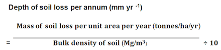
The bulk density (Mg/m3) of soils in each of the 5 case study catchments and for the national scale was determined using a set of (as yet unpublished) regression equations; one to predict the bulk density of mineral topsoils and a separate one to predict the bulk density of organic top soils, based on the proportion of carbon and clay (mineral soils) and carbon concentration (peaty soils) derived from the SSKIB dataset. As an illustration, the bulk density values for each land use and Erosion Risk Class for Scotland as a whole (national scale) are given in Table 16. The values for each of the case study catchments are given in Appendix 3. The data for each of the catchments and for the country as a whole were then used in Equation 5 to derive the depth of soil loss per annum from the rate of soil loss given for each land use in Table 8. The results for soil depth loss for Scotland as a whole are shown in Table 17.
| Land use | Bulk density (Mg/m3) | |||
|---|---|---|---|---|
| Erosion Risk Class | ||||
| Low | Moderate | High | Organo-mineral soils and peats | |
| Horticulture | 1.30 | 1.09 | 1.13 | 0.18 |
| Arable intensive | 1.44 | 1.29 | 1.13 | 0.18 |
| Arable extensive | 1.53 | 1.40 | 1.41 | 0.22 |
| Grassland improved | 1.41 | 1.45 | 1.11 | 0.15 |
| Grassland unimproved | 1.57 | 1.14 | 0.41 | 0.10 |
| Rough grazing | 1.07 | 1.06 | 0.62 | 0.12 |
| Rough grass | 1.10 | 0.98 | 0.62 | 0.05 |
| Forestry | 1.53 | 1.40 | 1.41 | 0.22 |
| Woodland | 1.63 | 1.31 | 0.83 | 0.12 |
| Wildscape | 0.70 | 0.49 | 0.33 | 0.05 |
| Land use | Soil depth loss (mm yr-1) | |||
|---|---|---|---|---|
| Erosion Risk Class | ||||
| Low | Moderate | High | Organo-Mineral soils and peats | |
| Horticulture | 0.26 | 0.30 | 0.27 | 4.11 |
| Arable intensive | 0.30 | 0.33 | 0.31 | 5.87 |
| Arable extensive | 0.16 | 0.17 | 0.17 | 2.31 |
| Grassland improved | 0.21 | 0.21 | 0.27 | 0.68 |
| Grassland unimproved | 0.13 | 0.18 | 0.50 | 0.38 |
| Rough grassland | 0.07 | 0.07 | 0.12 | 0.35 |
| Forestry | 0.04 | 0.05 | 0.07 | 0.08 |
| Woodland | 0.04 | 0.05 | 0.07 | 0.11 |
| Wildscape | 0.09 | 0.12 | 0.18 | 0.26 |
In order to calculate the impact of erosion on the loss of yield using the calculated soil depth losses, a production model was developed based on the proportion of crops in each land use / erosion risk class category. The area of those categories that were “unknown” in the spatial data were distributed to the known categories in proportion to their occurrence. The distribution was then simplified, as appropriate, to the key crops that were used in the modelling.
Crop yield data and crop sale values for these land use/ erosion risk class categories were developed from The Farm Management Handbook 2018/19 (SAC Consulting, 2018), cofunded by the Scottish Government and EU as part of the SRDP Farm Advisory Service. Grass yields for peat were taken from Morris et al. (2010) and the annual per hectare yield of timber was developed from Forestry Commission data for timber production and values (Haw, 2017).
6.4.2. Erosion induced nutrient loss
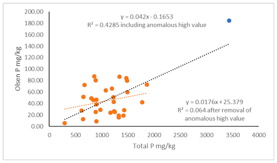
The mean organic carbon (C; % by weight of air-dried soil), nitrogen (N), phosphorus (P) and potassium (K) concentrations (mg kg-1 of air-dried soil) of each of the Soil Erosion Risk Classes were calculated for each catchment and at the national scale from the data held within the Scottish Soils Knowledge and Information Base (SSKIB). This dataset comprises summary data derived from the soil profile data held within the Scottish Soils Database for the main Scottish Soil Series. Organic C content (% by weight of air-dried soil) for top soils was derived primarily by CN analyser or by dichromate digestion. Total P concentration was determined by colorimetric methods following sodium hydroxide fusion and using a Discrete Analyser. K concentrations (mg kg-1) were determined by inductively coupled plasma emission spectrometry in a ammonium acetate solution. N concentrations (mg kg-1 ) were mainly determined by CN analyser. The data to calculate nutrient loss was derived for each of the 5 individual catchments and for Scotland as a whole for the national scale erosion costings (Appendix 4 - 7). Results for C and nutrient contents at the national scale are shown in Table 18; Table 19; Table 20; and Table 21.
| Land Use | Soil erosion risk class | |||
|---|---|---|---|---|
| Low | Moderate | High | Organo-mineral soils and peats | |
| Horticulture | 43.33 | 35.82 | 30.19 | 283.19 |
| Arable intensive | 48.54 | 39.12 | 30.19 | 283.19 |
| Arable extensive | 50.71 | 48.23 | 41.64 | 352.05 |
| Grassland improved | 58.77 | 70.67 | 86.23 | 334.56 |
| Grassland unimproved | 87.46 | 137.31 | 91.91 | 299.90 |
| Rough grassland | 76.73 | 127.55 | 102.73 | 361.97 |
| Forestry | 56.74 | 124.53 | 155.77 | 467.11 |
| Woodland | 72.87 | 107.35 | 135.37 | 301.59 |
| Wildscape | 71.47 | 86.71 | 59.61 | 166.73 |
| Land Use | Soil erosion risk class | |||
|---|---|---|---|---|
| Low | Moderate | High | Organo-mineral soils and peats | |
| Horticulture | 3.44 | 2.60 | 1.83 | 11.06 |
| Arable intensive | 3.87 | 2.94 | 1.83 | 11.06 |
| Arable extensive | 4.04 | 3.70 | 2.97 | 14.14 |
| Grassland improved | 4.65 | 5.44 | 5.96 | 14.01 |
| Grassland unimproved | 6.09 | 8.11 | 4.63 | 12.41 |
| Rough grassland | 5.09 | 7.95 | 5.76 | 14.66 |
| Forestry | 4.05 | 8.05 | 9.55 | 18.66 |
| Woodland | 5.34 | 7.05 | 8.41 | 12.34 |
| Wildscape | 4.16 | 4.65 | 3.12 | 6.73 |
| Land Use | Soil erosion risk class | |||
|---|---|---|---|---|
| Low | Moderate | High | Organo-mineral soils and peats | |
| Horticulture | 1.19 | 0.85 | 0.76 | 0.58 |
| Arable intensive | 1.31 | 1.01 | 0.76 | 0.58 |
| Arable extensive | 1.36 | 1.25 | 1.05 | 0.82 |
| Grassland improved | 1.19 | 0.85 | 0.76 | 0.58 |
| Grassland unimproved | 1.41 | 1.63 | 1.30 | 0.73 |
| Rough grassland | 1.01 | 1.22 | 0.71 | 0.64 |
| Forestry | 1.03 | 1.31 | 1.15 | 0.85 |
| Woodland | 1.63 | 1.31 | 0.83 | 0.12 |
| Wildscape | 0.70 | 0.49 | 0.33 | 0.05 |
| Land Use | Soil erosion risk class | |||
|---|---|---|---|---|
| Low | Moderate | High | Organomineral soils and peats | |
| Horticulture | 0.04 | 0.08 | 0.07 | 0.35 |
| Arable intensive | 0.13 | 0.10 | 0.07 | 0.35 |
| Arable extensive | 0.14 | 0.13 | 0.10 | 0.36 |
| Grassland improved | 0.15 | 0.16 | 0.17 | 0.30 |
| Grassland unimproved | 0.19 | 0.21 | 0.12 | 0.26 |
| Rough grassland | 0.14 | 0.20 | 0.15 | 0.31 |
| Forestry | 0.14 | 0.21 | 0.25 | 0.43 |
| Woodland | 0.17 | 0.20 | 0.22 | 0.28 |
| Wildscape | 0.11 | 0.11 | 0.08 | 0.13 |
Whilst Table 18 to Table 21 provide data on the quantity of C, N, P and K in the soil, it is worth noting that erosion selectively takes the most important components of the soil first and eroded soils can typically contain three times more nutrients than the soil left behind (Ali, Khan and Bhatti, 2006; Lal, 1998; Sharpley, 1980). Enrichment ratios measure the relative concentrations of nutrients in deposited material and in the soil from which that eroded material came. A range of enrichment ratios and the enrichment ratios used in this study are shown in Table 22. These were used to calculate the eventual quantity of C, N, P and K lost in the eroded material per annum for each of the land use / erosion risk class combinations. It should be noted that it was not possible to differentiate between the bioavailable and total fraction of P and K. The total soil nutrient content was used in the calculations.
| Nutrient | Range of enrichment ratios | Mean ER |
|---|---|---|
| P | 1.32 - 3.04 (Zheng et al., 2005) 1.47 (Sharpley, 1985) 2.79 (Ali et al., 2006) |
2.15 |
| OC / OMC | 1.08 - 1.4 (Zheng et al., 2005) 0.9 - 2.6 (Schiettecatte et al., 2008) 2.00 (Sharpley, 1985) 1.23 (Ali et al., 2006) |
1.56 |
| N | 0.89 - 1.26 (Zheng et al., 2005) 1.61(Sharpley, 1985) 1.43 (Ali et al., 2006) |
1.37 |
| K | 2.90 (Ali et al., 2006) | 2.90 |
The value of the soil nutrients was given by the SAC Farm Management Handbook (SAC Consulting, 2018; Table 23) and used to calculate the value of the N, P, K and C lost in the eroded material.
Table 23. The value of soil nutrients (from SAC Farm Management Handbook (2018/19))
Fertiliser cost of N 0.67 £ / kg
Fertiliser cost of P 0.68 £ / kg
Fertiliser cost of K 0.45 £ / kg
Fertiliser cost of C 0.67 £ / kg
6.5. Calculating annual off-site costs
As well as the on-site impacts of erosion, there are a variety of off-site costs incurred each year, associated with the cost of Greenhouse Gas Emissions, and costs associated with reduced environmental and drinking water quality associated with the eroded sediment and nutrients.
6.5.1. Greenhouse gas impact of soil erosion
Greenhouse gases such as methane (CH4) nitrous oxide (N2O) and carbon dioxide (CO2) contribute to climate change. Several studies have estimated the per unit cost of this. For example, Eyre et al. (1997) proposed costs of £63 t-1 for CO2, £263 t-1 for CH4 and £7,530 t1 for N2O. Jacobs and SAC (2008) uses a value of £25 t-1 CO2 based on the shadow price of carbon proposed by Defra. More recently, the EU Emissions Trading System (ETS) has created a market in GHG emissions, which provides a traded carbon price based on abatement costs. Agricultural emissions currently exist outside the ETS, but the UK Government’s Department for Business, Energy and Industrial Strategy (BEIS) (BEIS, 2019) has advised that non-traded carbon prices (£68 t-1 CO2e for 2019) should be used in such cases. It should be noted that these value will increase in future years as carbon trading process increase (Tom McKenna, personal communication). Jacobs and SAC (2008) has provided ratios (21:1 for CH4 and 310:1 for N2O) to calculate global warming potential (GWP) for other GHG gases giving a per unit cost of £1,428 t-1 CH4 and £20,080 t-1 N2O.
However, in the present study, no data on methane or nitrous oxide emissions specifically linked to soil erosion were found. Some studies refer to management practices that will reduce GHG emissions whilst also controlling soil erosion (Jarecki and Lal, 2006; Johnson et al., 2007; Smith and Olesen, 2010). However, they do not quantify the amount of these GHGs that are associated with soil erosion. Ball (2013) draws on research from Scotland, Japan and New Zealand to examine how soil structures affected by wheel compaction, animal trampling, tillage and land-use change influence GHG emissions in order to help identify key controlling properties, but soil erosion is not mentioned explicitly.
Whilst many papers (e.g. Powlson et al. (2011) outline the importance of the stock of soil C in climate regulation, data on the proportion of C in eroded material that is released to the atmosphere to form CO2 is also lacking. Lal (2003) provides an estimate at a global scale in which he proposes that approximately 20% of the soil C that is eroded each year is emitted to the atmosphere as CO2. The ratio of organic C in the soil to CO2 in the atmosphere is given as 3.67 (Williams, Audsley and Sandars, 2006), and the assumed quantity of eroded C emitted to the atmosphere was multiplied by this ratio to obtain its Global Warming Potential (t CO2e). Using these assumptions, the annual cost of GHG emissions from eroded soils in Scotland was estimated to be £10.881 million (Table 24).
| Land use | GHG cost of soil C loss (£ per annum) | ||||
|---|---|---|---|---|---|
| Soil Erosion Risk Class | |||||
| Low | Moderate | High | Organo mineral soils and peats* |
Total | |
| Horticulture | 55 | 528 | 40 | 62 | 685 |
| Arable intensive | 1,391 | 25,110 | 934 | 11,262 | 38,698 |
| Arable extensive | 26,312 | 425,092 | 16,046 | 302,657 | 770,107 |
| Grassland improved | 57,709 | 1,700,707 | 247,893 | 959,597 | 2,965,907 |
| Grassland unimproved | 677 | 55,880 | 122,885 | 435,721 | 615,163 |
| Rough grassland | 2,155 | 230,979 | 342,575 | 4,084,078 | 4,659,787 |
| Forestry | 1,236 | 147,471 | 131,185 | 817,902 | 1,097,794 |
| Woodland | 1,298 | 87,036 | 79,003 | 118,426 | 285,763 |
| Wildscape | 254 | 23,568 | 73,039 | 350,040 | 446,901 |
| Total | 91,088 | 2,696,371 | 1,013,601 | 7,079,747 | 10,880,806 |
* The calculations of all costs for arable and improved grassland on organo-mineral soils and peats may be an overestimate as there is a mismatch in scale between the soil spatial data set and the land use (see Section 8.6 for full explanation).
6.5.2. Impact on watercourses of nutrients lost in eroded material
Whilst the loss of nutrients in eroded material represents the loss of a productive asset, the removal of the N and P into water represent a risk to the quality of the water environment, the costs of which are born by third parties. A summary of those costs associated with eroded soils are shown in Table 25. Figures specific to Scotland were not available, so Table 25 uses data derived previously for England and Wales.
| Value | Unit | |||
|---|---|---|---|---|
| Environmental water quality | Rivers, canals | NO3-N | 190 | £ t-1 |
| Freshwater lakes | P | 1,407 | £ t-1 | |
| Transitional water | NO3-N | 10 | £ t-1 | |
| Drinking water quality | Nitrate | NO3-N | 203 | £ t-1 |
| Sediment | Soil | 18 | £ t soil-1 | |
It is noticeable that data are only available for P in freshwater lakes and NO3-N only in rivers, canals and transitional waters. This is discussed in Section 10.4.4 below.
6.5.3. Costs of N in rivers and canals
Damage costs to rivers and canals are linked to levels of NO3-N and the apportionment to agriculture was estimated as £47.4 million (adjusted to 2009 values) in Jacobs and SAC (2008). Since NO3-N data are not given in Jacobs and SAC (2008), the total of 295,409 t NO3-N for agriculture in the UK was taken from Defra project WQ0106 (Anthony et al., 2009) giving a ‘per unit’ damage cost of £161 t-1 NO3-N. This value was inflated to 2019 values using GDP inflators from BEIS (2019) to obtain a cost of £190 t-1 NO3-N.
The off-site damage cost associated with N in the eroded soil in rivers and canals at the national scale was estimated to be £1.858 million per annum (Table 26).
| Land use | Cost of N in rivers and canals (£ per annum) | ||||
|---|---|---|---|---|---|
| Erosion Risk Classes | |||||
| Low | Moderate | High | Organomineral soils and peats |
Total | |
| Horticulture | 14.79 | 132.10 | 9.60 | 8.01 | 164 |
| Arable intensive | 371.48 | 6,283.13 | 223.06 | 1,462.97 | 8,341 |
| Arable extensive | 7,055.54 | 109,118.05 | 3,830.23 | 40,651.08 | 160,655 |
| Grassland improved | 15,362.91 | 437,726.36 | 57,343.83 | 134,270.66 | 644,704 |
| Grassland unimproved | 158.41 | 11,034.69 | 20,687.11 | 60,255.20 | 92,135 |
| Rough grassland | 501.78 | 48,752.73 | 64,396.64 | 553,452.02 | 667,103 |
| Forestry | 294.55 | 31,887.70 | 26,885.45 | 109,197.57 | 168,265 |
| Woodland | 318.07 | 19,150.08 | 16,417.44 | 16,196.62 | 52,082 |
| Wildscape | 49.53 | 4,219.93 | 12,763.58 | 47,242.96 | 64,276 |
| Total | 24,127 | 668,305 | 202,557 | 962,737 | 1,857,726 |
6.5.4. Sediment removal by dredging rivers and canals
No figures are available specifically for Scotland. In England and Wales, Anthony et al. (2009) divided the annual costs of dredging sediment out of water courses (£9.8 million in 2009) by the total sediment load (1,906,260 t yr-1) to give a unit cost of £5.2 t-1 sediment. This value was inflated in the present project to 2019 values using GDP inflators from BEIS 2019 to obtain a cost of £6.1 t-1 eroded material.
From this, the off-site damage cost associated with sediment removal from water courses in Scotland was estimated to be £4.733 million per annum (Table 27).
| Land use | Cost of sediment removal in rivers & canals (£ per annum) Erosion Risk Classes |
Total | |||||
|---|---|---|---|---|---|---|---|
| Low | Moderate | High | Organo-Mineral soils and peats | ||||
| Horticulture | 75 | 882 | 64 | 14 | 1,036 | ||
| Arable intensive | 1,891 | 41,966 | 1,484 | 2,64 | 47,986 | ||
| Arable extensive | 34,468 | 582,662 | 25,483 | 56,73 | 699,350 | ||
| Grassland improved | 65,303 | 1,593,534 | 191,011 | 189,430 | 2,039,278 | ||
| Grassland unimproved | 515 | 26,923 | 88,380 | 96,06 | 211,885 | ||
| Rough grassland | 2,286 | 132,466 | 221,584 | 768,540 | 1,124,876 | ||
| Forestry | 1,454 | 78,197 | 55,601 | 115,826 | 251,079 | ||
| Woodland | 1,178 | 53,682 | 38,620 | 25,98 | 119,464 | ||
| Wildscape | 238 | 17,702 | 80,917 | 138,889 | 237,745 | ||
| Totals | 107,408 | 2,528,013 | 703,145 | 1,394,13 | 4,732,699 | ||
6.5.5. Costs of P loads in lakes / lochs
Graves et al. (2011) estimate the cost of eutrophication in lakes in the UK as £62.6 million
(adjusted to 2009 values) and linked this to an estimated P load of 45% from agriculture (Jacobs and SAC, 2008), giving an apportionment of £28.2 million to agriculture. It should be noted that the apportionment to agriculture varies significantly amongst different sources and has been reported as 29.2% in Defra Project WT0701CSF (White and Hammond, 2006) (Table 28). Since physical units for P are not given in Jacobs and SAC (2008), the total load given for the UK in Defra Project WT0701CSF (43,796 t yr-1) is used as a proxy to develop a ‘per unit cost’ for phosphorus (£ t-1 P) from the total cost in Jacobs and SAC (2008), giving a ‘per unit cost’ of £1,407 t-1 P (Table 25) that can be attributed to the risk of P in lakes / lochs, lost from soils via erosion.
The off-site damage cost associated with the P in eroded soil (sediment) in lakes was estimated to be £3.708 million per annum (Table 29).
| England | Wales | Scotland | N Ireland | UK | |
|---|---|---|---|---|---|
| t yr-1 | t yr-1 | t yr-1 | t yr-1 | t yr-1 | |
| Agriculture | 8,391 | 2,151 | 1,223 | 1,023a | 12,788 |
| Household | 21,677 | 1,333 | 2,246 | 988b | 26,245 |
| Industrial | 645 | 70 | 1,179 | 40 | 1,934 |
| Background | 1,561 | 243 | 902 | 123 | 2,829 |
| Total | 32,274 | 3,797 | 5,551 | 2,174 | 43,796 |
| Percentage contributions (%) | |||||
| Agriculture | 26 | 56.6 | 22 | 47.1 | 29.2 |
| Household | 67.2 | 35.1 | 40.5 | 45.4 | 59.9 |
| Industrial | 2 | 1.8 | 21.2 | 1.8 | 4.4 |
| Background | 4.8 | 6.4 | 16.2 | 5.7 | 6.5 |
a Adjusted for rural population (-107 t TP yr-1) as described by Smith et al. (2005)
b Adjusted for P removal programme (-145 t TP yr-1) as described by Smith et al. (2005)
| Land use | Cost of P in fresh water lakes (£ per annum) | ||||
|---|---|---|---|---|---|
| Erosion Risk Class | |||||
| Low | Moderate | High | Organomineral soils and peats | Total | |
| Horticulture | 69 | 622 | 46 | 6 | 743 |
| Arable intensive | 1,731 | 29,572 | 1,075 | 1,059 | 33,437 |
| Arable extensive | 32,698 | 506,520 | 18,458 | 32,394 | 590,070 |
| Grassland improved | 64,147 | 1,792,235 | 171,749 | 95,635 | 2,123,765 |
| Grassland unimproved | 527 | 24,770 | 27,989 | 35,602 | 88,888 |
| Rough grassland | 1,619 | 108,677 | 108,871 | 330,570 | 549,738 |
| Forestry | 1,035 | 71,127 | 44,388 | 67,937 | 184,487 |
| Woodland | 1,176 | 49,740 | 26,324 | 9,715 | 86,954 |
| Wildscape | 110 | 6,683 | 18,047 | 25,094 | 49,934 |
| Total | 103,112 | 2,589,944 | 416,947 | 598,012 | 3,708,016 |
6.5.6. Costs of N loads in transitional waters
The costs of damage by soil erosion to transitional waters are also linked to nitrate and are estimated from Jacobs and SAC (2008) to be to be £79,147 yr-1 (adjusted to 2019 values) for Scotland. The physical data developed by Defra project WQ0106 (Anthony et al., 2009) for nitrate losses by agriculture in England and Wales was used to obtain the ‘per unit’ value of £8.9 t-1 NO3-N. This value was inflated to 2019 values using GDP inflators from BEIS 2019 to obtain a cost of £10 t-1 NO3-N (Table 25).
The off-site damage cost associated with N in the eroded soil (sediment) in transitional waters was estimated to be £97,775 per annum (Table 30).
| Land use | Cost of N in transitional waters (£ per annum) | ||||
|---|---|---|---|---|---|
| Erosion Risk Classes | |||||
| Low | Moderate | High | Organomineral soils and peats | Total | |
| Horticulture | 1 | 7 | 1 | 0 | 9 |
| Arable intensive | 20 | 331 | 12 | 77 | 439 |
| Arable extensive | 371 | 5,743 | 202 | 2,140 | 8,456 |
| Grassland improved | 809 | 23,038 | 3,018 | 7,067 | 33,932 |
| Grassland unimproved | 8 | 581 | 1,089 | 3,171 | 4,849 |
| Rough grassland | 26 | 2,566 | 3,389 | 29,129 | 35,111 |
| Forestry | 16 | 1,678 | 1,415 | 5,747 | 8,856 |
| Woodland | 17 | 1,008 | 864 | 852 | 2,741 |
| Wildscape | 3 | 222 | 672 | 2,486 | 3,383 |
| Total | 1,270 | 35,174 | 10,661 | 50,670 | 97,775 |
6.5.7. Nitrate removal in drinking water
Removal of nitrate in freshwater imposes costs on water companies. The agricultural apportionment of this is assumed to be 61% giving a total cost (adjusted to 2009 values) of £51 million (Jacobs and SAC, 2008). The agricultural load of NO3-N (295,409 t yr-1) estimated for England and Wales by Anthony et al. (2009) is used to derive the per unit cost (£ 172 t-1 NO3-N) for removal of nitrate from drinking water (in that case associated with livestock applications on grassland, but the removal costs will be the same, whatever the mechanism of getting the nitrate into the sources of drinking water). This value was inflated to 2019 values using GDP inflators from BEIS 2019 to obtain a cost of £203 t-1 NO3-N (Table 25).
The off-site damage cost associated with the N in eroded soil in drinking water was estimated to be £1.985 million per annum (Table 31).
| Land use | Cost of N in drinking water (£ per annum) | ||||
|---|---|---|---|---|---|
| Erosion Risk Class | |||||
| Low | Moderate | High | Organo mineral soils and peats | Total | |
| Horticulture | 16 | 141 | 10 | 9 | 176 |
| Arable intensive | 397 | 6,713 | 238 | 1,563 | 8,911 |
| Arable extensive | 7,538 | 116,584 | 4,092 | 43,432 | 171,647 |
| Grassland improved | 16,414 | 467,676 | 61,267 | 143,458 | 688,815 |
| Grassland unimproved | 169 | 11,790 | 22,103 | 64,378 | 98,439 |
| Rough grassland | 536 | 52,088 | 68,803 | 591,320 | 712,747 |
| Forestry | 315 | 34,069 | 28,725 | 116,669 | 179,778 |
| Woodland | 340 | 20,460 | 17,541 | 17,305 | 55,646 |
| Wildscape | 53 | 4,509 | 13,637 | 50,475 | 68,674 |
| Total | 25,778 | 714,031 | 216,416 | 1,028,609 | 1,984,833 |
6.5.8. Sediment removal in drinking water
The total cost of sediment removal is assumed to be 50% of OFWAT's 'other' expenditure (Jacobs and SAC, 2008). This gives a total cost of sediment removal of £38.6 million. Agriculture is assumed to contribute about 75% of the total sediment load in watercourses (Collins et al., 2012), suggesting a cost of £29 million to remove this sediment. If this number is divided by the total load of sediment from agriculture (given as 1,906 kt yr-1 by Anthony et al. (2009) for England and Wales (in the absence of equivalent figures specifically for Scotland)), this gives a per unit cost of £15.4 t-1 sediment. This value was inflated to 2019 values using GDP inflators from BEIS 2019 to obtain a cost of £18 t-1 erosion.
The off-site damage cost associated with sediment removal in drinking water was estimated to be £16.542 million per annum (Table 32).
| Land use | Cost of sediment removal in drinking water (£ per annum) | ||||
|---|---|---|---|---|---|
| Erosion Risk Classes | |||||
| Low | Moderate | High | Organomineral soils and peats | Total | |
| Horticulture | 263 | 3,084 | 223 | 51 | 3,621 |
| Arable intensive | 6,610 | 146,677 | 5,187 | 9,245 | 167,719 |
| Arable extensive | 120,470 | 2,036,487 | 89,067 | 198,306 | 2,444,330 |
| Grassland improved | 228,243 | 5,569,634 | 667,612 | 662,085 | 7,127,575 |
| Grassland unimproved | 1,800 | 94,098 | 308,902 | 335,767 | 740,568 |
| Rough grassland | 7,989 | 462,989 | 774,468 | 2,686,159 | 3,931,605 |
| Forestry | 5,083 | 273,309 | 194,335 | 404,830 | 877,557 |
| Woodland | 4,118 | 187,626 | 134,984 | 90,816 | 417,543 |
| Wildscape | 831 | 61,872 | 282,815 | 485,436 | 830,955 |
| Totals | 375,407 | 8,835,775 | 2,457,594 | 4,872,696 | 16,541,473 |
Contact
Email: resasadmin@gov.scot
There is a problem
Thanks for your feedback