Green infrastructure: design and placemaking
Report on design and placemaking in the green infrastructure.
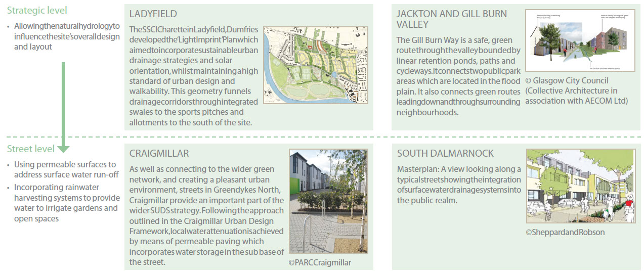
Part 2: Green Infrastructure and Masterplanning
How?
Looking at a site
When starting to look at a site it's helpful to think about the 3 elements of site appraisal: Context, Identity and Connection which are set out in PAN 83 Masterplanning.
Green infrastructure can be used as a way of looking at and reinforcing each of the appraisal elements. Below are ideas of the green infrastructure elements to look for within each site appraisal element:
Context
- Location and surroundings
- Natural features
- Views
- Topography, natural undulations
- Hydrology and drainage (existing watercourses, pressures on watercourses, groundwater, sewer network and soil type)
- Microclimate (wind, sun, orientation, exposure, shelter)
- Wider green networks
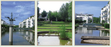
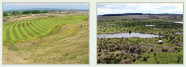
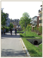
Images from Scotland's Housing Expo 2010 © Cadell2
Identity
- Landscape character
- Green and blue corridors
- Greenspaces
- Flora and fauna
- Wildlife habitats (woodlands, grasslands & wetlands)
Connection
- Pedestrian movement, desire lines, green corridors, core paths, cycle routes, rights of way
- Habitat networks, linkages
- Vehicular movement; existing roads/transport connections, crossings
- The water journey, where does water go? (streams/areas prone to flooding etc)
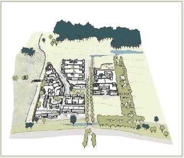
Examples of how to consider Green Infrastructure during a site appraisal
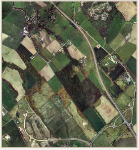
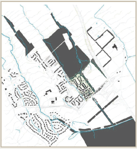
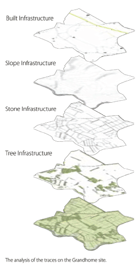
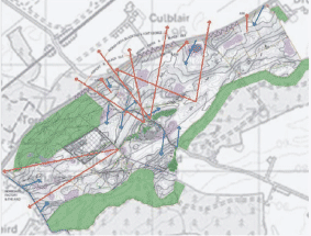
GRANDHOME
In the Grandhome SSCI Charette the design team mapped the existing 'traces on the land'.
Traces include paths, roads, ponds, woods, slopes, streams, wetlands or agricultural traces such as irrigation ditches or stone walls.
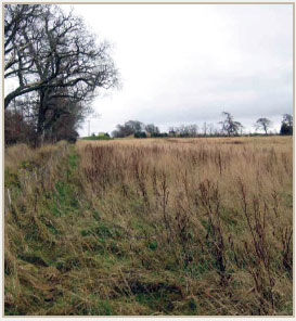
"Design the parks and squares around ponds, wooded areas or specimen trees as much as possible, so that mature trees grace the public spaces of the community from the outset."
TORNAGRAIN
The Tornagrain SSCI project shows how an understanding of topography and key views has been utilised and combined with a skilful approach to urban design. The existing landscape provided a starting point to inform the creation of distinctive neighbourhoods within the masterplan.
The green network takes the form of a series of natural and formalised spaces, each with its own character and identity and serving an important context for built development. Retention and enhancement of the surrounding woodland resource provides a wider landscape and recreational context for the settlement whilst offering important physical connections for people and wildlife to the wider proposed A96 green network project.
- Understand the topography
- Make the most of views from the site
- Think about how the development will be seen
- Use the existing landscaping and trees to reinforce the unique context and create attractive settings for development
INTEGRATED URBAN INFRASTRUCTURE
A series of four Design Studies have been carried out for:
- Johnstone South West
- The Burgh of Pollockshaws
- Jackton and Gill Burn
- Cowlairs Urban Village
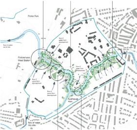
© Glasgow City Council
(Collective Architecture in association with AECOM Ltd)
These design studies look at how understanding water's behaviour can create new opportunities for quality developments and how pressures on the water environment can be addressed, so that water can be integrated into the design of urban areas, as part of the answer rather than the problem.
Green Infrastructure and Masterplanning
Creating a masterplan
Designing Places (2001) sets out the Government's aspirations for design and identifies six qualities of successful places.

The next section of this document, looks at each of the six qualities in turn and gives examples of ways that green infrastructure can deliver on each of these qualities to create high quality sustainable places and contribute to placemaking. It is intended to provide examples of issues policy planners should be including in plans and development briefs, ideas for designers in developing proposals and setting out things that planners should be looking for when assessing masterplans and planning applications.
Welcoming
Distinctive
Safe and Pleasant *1
Easy to move around
Resource Efficient
Adaptable *2
* Photo credits 1: Cadell2 2: Assist Architects
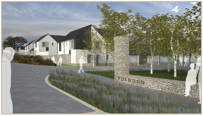
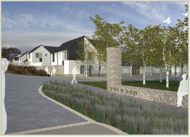
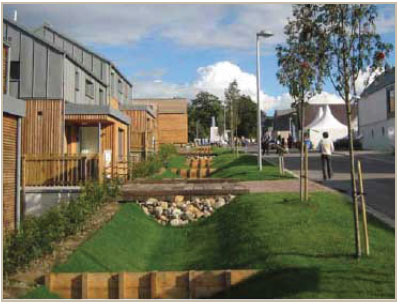
Polnoon - Masterplan: Idea to design
Welcoming
Welcoming places are open, pleasant and well connected, this can help people find their way around a place, new district or development. Masterplans should consider how landmarks and layouts can make it easy for people to find their way around. Green infrastructure features are a useful way to form clear and attractive entrances and maintain and inject distinctive features, landmarks and routes into a place to make it more welcoming.
Including entrance and gateway features
Green infrastructure features, such as feature trees, tree avenues or other forms of planting, can be celebrated and used to form clear entrances and gateways.
POLNOON, EAST RENFREWSHIRE
The main entrance has an emphasis on safety and landscaping. The design retains an existing hedge which the houses sit behind and a new pathway connects into the development.
Making it easy to find your way around
Many people find it easy to navigate themselves in relation to a key feature or route such as the location of a river or watercourse, where possible these should be made key parts of the design rather than sidelined.
Keeping large trees, water features and other natural physical features such as hills can form landmarks that residents and visitors can easily recognise and use to help find their way about.
Creating places with a positive image
Welcoming places make people feel relaxed and at ease. Trees and other landscaping not only help to make places feel leafy and attractive, they can also give us fresh air, promoting a sense of well-being.
Making good use of views (into, within and out of a development) can also take in glimpses of greenspaces, and provide a high quality landscape setting for development.
Polnoon - Masterplan: Idea to design
Distinctive
Special and memorable places are often distinctive and easily recognisable, particularly when compared with standard 'anywhere developments'. High quality design can give developers that unique selling point. Creating a unique and distinctive place often means embracing the local context and taking it as design inspiration. Green infrastructure can both provide that local context and be enhanced and added to, to create attractive, distinctive places.
Reinforcing local landscape character and identity
Making the most of the existing landscape, natural features and topography.
AN CAMAS MOR, NEAR AVIEMORE
This project seeks to avoid sensitive habitats and utilises existing site topography and natural vegetation to inform the layout of the open space and built form. The vision of a compact and distinctive new community in a woodland setting is taken forward by an approach that starts with the existing natural assets of the site and builds a design approach that concentrates on: "life, space and buildings" (in that particular order), with the aim to: "create a good habitat for humans".
© An Camas Mòr
Using unique design features
For example, not only can SUDS, buffer strips and innovative landscapes help address flooding, they can form water features, adding a lot to the design and feel of a place, creating attractive, tranquil settings for development. Opening up watercourses and addressing pressures arising from culverting, embankments and realignment can facilitate attractive waterfront development often boosting property prices.
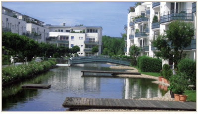
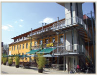
RENNPLATZ, REGENSBURG, BAVARIA
The Rennplatz was a former racecourse site. In redeveloping the site, the aim was clear: to create a new neighbourhood of both high density and good quality. Despite the high density, there was a concerted effort to create a 'green concept'; 30% of the site is green. This includes integrated play space areas and public art - which not only looks good, but is also interactive. The site contains many water features. The sustainable drainage system ( SUDS) is open planned, positioned as an attractive feature and designed to be used as a skating rink in the winter.
Creating a sense of place
Green Infrastructure can intrinsically promote a sense of identity and character, working what's there locally to inform the design.
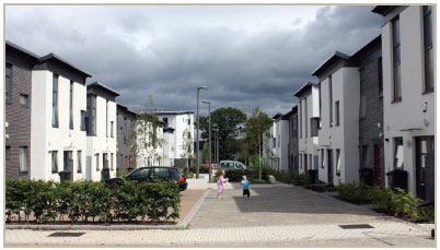
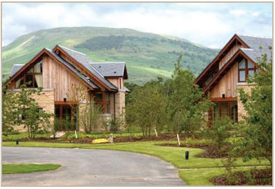
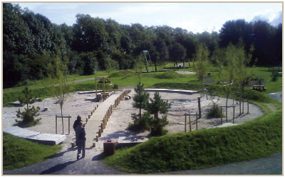
HOUSING EXPO
The masterplan for the Balvonie site, near Inverness, incorporates the wider green infrastructure/ecosystem services to provide the landscape setting. The design responds to the topography and landscape using the street layout to take advantage of views to give a true sense of the Highland identity.
© Cadell2
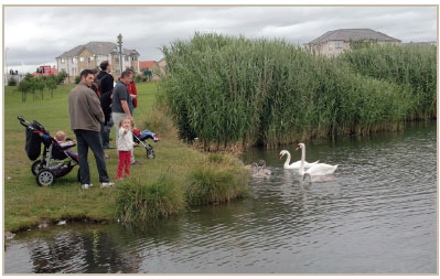
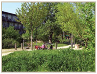
Safe and pleasant
Green infrastructure can create pleasant places for fun, play and relaxation. Green networks, such as paths and cycle ways can provide safe off-road routes for walkers, joggers and cyclists away from vehicles and emissions. The masterplan stage is a key point to look ahead and consider safety issues and perceptions, this is the stage when the design and layout can be most easily adapted to create safer places.
Creating a series of safe and attractive places to meet, talk and play
Open spaces should be well-located, linking into the wider green network, and connecting into well used routes. Overlooking of open space and routes by buildings and streets provides natural observation from residents, pedestrians and passing motorists. This can encourage people to use these places where they feel safe.
Green infrastructure features can provide stimulating opportunities for play and places to enjoy sport and recreation. Designs should create places that are attractive and easily accessible to all regardless of age and ability.
Layouts should be designed so that the houses face onto the open space, providing surveillance, and placing the play spaces at the heart of the development.
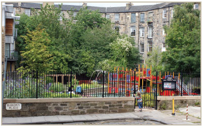
Barony Community Garden, Edinburgh
Addressing risks through design
Lighting within green networks can help to reduce crime, provide reassurance, as well as making areas more enchanting and appealing.
Boundary features including hedges and walls can help define public and private spaces and increase the feeling of community ownership and responsibility, they can also contribute to the green network providing habitats for birds, insects and small animals.
SUDS, particularly open ponds and wetlands are often perceived as posing risks of drowning. So the principles of safety by design should be embraced. Careful design can help to minimise or design out risks so that SUDS features pose little or no risk. This can be done through easy design solutions like including gentle side slopes and shallow shelves within ponds and wetlands.
Dunfermline © Collective Architecture
Delivering quality through design and maintenance
High quality facilities and public spaces should be designed to be durable and appropriate to the location to ensure continuing high standards.
It is important at the design stage to think about the different maintenance regimes different types of green infrastructure will need. For example green corridors, and semi-natural greenspaces may require less ongoing maintenance and costs than more formal types of open space.
The maintenance programme should be tuned to the type of space, durability, wildlife habitats present, level of usage and local interests. The management and maintenance regime including ownership and responsibilities and paying for the management and maintenance should be agreed early on, and suitable, transparent, arrangements put in place.
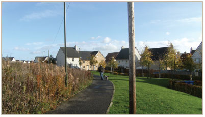
Raploch, river walk playpark. © Raploch URC Ltd
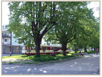
Easy to move around
Green networks provide attractive opportunities for walking and cycling, encouraging more people to take part in active travel more often, as a sustainable and viable alternative to the car. Green networks offer a range of other benefits: economic, social and environmental, including creating sustainable drainage systems, providing areas of green space and paths for recreation and social interaction, as well as improving habitat connectivity and tacking climate change through reducing carbon emissions.
Green Networks
Often the basis of an area's green infrastructure is already in place, egthe woodlands, shelter belts, green corridors, paths etc but there is added value in connecting these up so they function as a system - the whole really is greater than the sum of the parts.
Development inherently involves land use change, so it can offer a chance to think strategically, in particular with regard to green networks and how to incorporate and create them from the start, including putting in missing green links.
Masterplans should consider:
- the wider landscape or urban setting;
- the green networks in and around the site;
- the potential the development offers to join up existing networks; and
- where best to make green links and connections, to strengthen and enhance the green network.
Connections for…
people…
and wildlife

Paths and routes which are accessible to all
Core Path Plans: A Guide to Good Practice
- Significant natural features and other biodiversity should be protected and intrusion minimised, as appropriate in the design.
- As well as protection, masterplans should be thinking about how they can integrate and/or enhance surrounding habitats where appropriate.
- Opportunities should be taken to incorporate biodiversity features (such as green roofs) into the fabric of the buildings and the spaces between them.
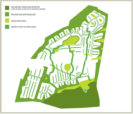
Integrated Habitat Network Model
This project was developed by Glasgow Green Network Partnership in association with Scottish Natural Heritage and Forestry Commission Scotland.
It creates a detailed habitat map of the Glasgow and Clyde Valley region for which habitat networks for woodland, grassland and wetland can be modelled. It can be interpreted to identify the location and types of habitat that need to be protected, enhanced or created.
SNH Habitat networks and spatial ecology webpages
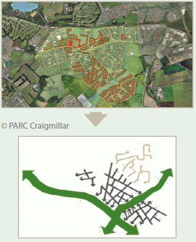
CRAIGMILLAR
The proposed development framework creates an integrated network of streets that promote good connectivity of residential areas with open space and wider green networks. By comparison, existing areas of housing show cul-de-sac style development and generally poor connectivity with open space and green networks.
Resource Efficient
SUDS and Water Resource Management
Having considered the area's natural hydrology, including any permanent or ephemeral watercourses, designers should make provision so that these can be kept and opportunities to deliver improvements to the water environment ( egopening up culverted watercourses) are harnessed wherever possible. Sustainable urban drainage systems and innovative landscapes to retain flood water should be considered early on as a means to deal with issues of water quantity, water quality and amenity in an integrated way.
SUDS work on the principles of: managing surface water run-off on-site as near to source as possible; slowing down run-off; treating it naturally; and releasing good quality surface water to watercourses or groundwater. Keeping surface water on the surface increases the capacity for flood storage, provides easy access for maintenance and is cheaper to construct. Moreover the end design solutions can become attractive amenity features within the development, and provide wildlife habitats.
SUDS can feature at both the strategic site-wide level and the street level, as shown below.
PAN 61 Planning and Sustainable Urban Drainage Systems
The goal in creating sustainable communities should be to reduce the environmental impact and carbon footprint of the development. Resource efficiency and making best use of what the site offers should be sincerely thought about.
Sustainable use of materials
Local and sustainable sources of materials should be used. Not only can this provide solutions that sit happily in their context, transporting materials can be minimised reducing emissions and transport costs. In addition working with the landscape to reduce the need for cut and fill to help reduce soil disturbance and movements.
HEARTLANDS, WEST LOTHIAN
Heartlands is on the site of the former Polkemmet Colliery in West Lothian and is one of the largest brownfield regeneration projects in Europe. The masterplan includes, homes, business land, community facilities and golf courses. One of the ideologies of the project is the theme of recycling and reusing material that is available on the site.
Recycled colliery waste is reused in the building of the golf courses. Ecosse Regeneration Ltd are championing the use of recycled materials in just about every part of the golf course construction. In possibly the first project of its kind in the world the golf courses are being built with a new technique that combines screened inert colliery waste shale from the coal bings on the Polkemmet site with high-quality locally produced compost avoiding the traditional method of importing tonnes of new topsoil and slashing the cost of regenerating the land.
Trees planted on the site will provide a future fuel source for biomass. Native tree species have been harvested from the remediation area to a nursery and will be replanted within the green ways and SUDS areas.
© Ecosse Regeneration Ltd
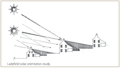
Microclimate and Saving Energy
Orientation
- Buildings and rooms within developments should be orientated to minimise energy use.
- Opportunities for roofs to incorporate solar hot water and solar PV should be considered.
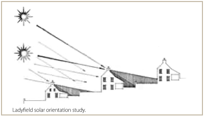
Shelter
- Structure planting, shelter belts and trees can provide shading and shelter for buildings and spaces enhancing the site's microclimate, and reducing heating costs in winter.
Insulation
- Green roofs can be used as an alternative way to provide insulation.
Cooling
- Blue spaces (water bodies) can provide cooling during summer months, stabilising urban temperatures - scope for incorporating them within developments should be considered.
- Trees can also provide a cooling function.
Renewable Energy
Infrastructure for sustainable energy should be designed in from the start, harnessing the natural resources that are available.
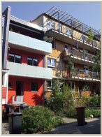
HOUSING EXPO: THE APARTMENTS
All heating and hot water demands for the six apartments is provided through an independent biomass boiler located within the curtilage of the plot.
(Keppie Design, William Gray Construction, Albyn Housing Society ©Ewan Wetherspoon)
- Design in green infrastructure from the start, egbiomass boiler and storage area.
- Think about scale.
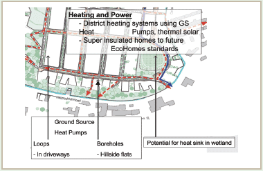
COWLAIRS, URBAN VILLAGE
Cowlairs is a 30ha site to the north of Glasgow city centre. It features an innovative approach with ground source heat pumps within the porous paving.
Adaptable
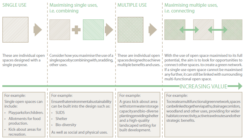
Masterplans should look to incorporate green infrastructure that can serve a number of different functions and adapt to future uses. Green infrastructure through green networks can offer a range of benefits to society. These benefits include; providing places for amenity, biodiversity, flood control, mitigation of pressures on the water environment, environmental education, growing food, outdoor activity and enjoyment.
Creating multi-functional open spaces
Green infrastructure including open spaces can offer a range of benefits to society, and creating multi-functional spaces increases the potential benefits.
- For example open spaces designed for amenity space, and biodiversity can also operate as outdoor classrooms giving children a chance to learn about nature and their environment.
- Football pitches can also be designed to hold large volumes of water during heavy rain, reducing the risk of flooding elsewhere.
- Sustainable drainage combines well with open space requirements as indicated below.
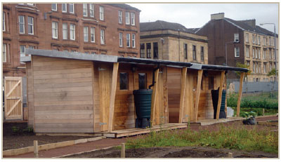
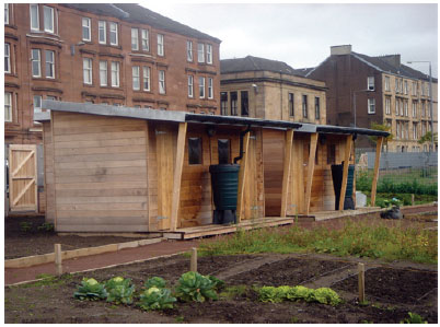
Providing opportunities for productive landscapes
Allotments, community gardens, and community orchards, as well as private gardens can provide access to fresh healthy fruit and veg, with fewer food miles, help encourage physical activity, and tackle health inequalities.
Where there is local demand for allotments or other forms of community growing, developers may wish to consider whether there is scope to include this type of open space within the development.
Community woodlands can also get local people involved in growing trees whether for fruit or to harvest as wood fuel for local heating systems.
© Assist Architects
Community Growing in Scotland - Towards a framework for action, Greenspace Scotland
LEARNING FROM ABROAD
DISTINCTIVE SUSTAINABLE NEIGHBOURHOOD - Vauban, Freiburg, Germany.
Vauban is part of a former French barrack site, in Freiburg. It was developed as a new district for more than 5,000 inhabitants and 600 jobs. The area has been internationally recognised as a sustainable and distinctive neighbourhood and features green infrastructure at the heart of the design concept. Below some of its GI features are shown against the 6 qualities of successful places.
Welcoming
- residential pattern around common courtyards, featuring green facades
- mixed uses at entrance to neighbourhood including café, enhanced with planting
Distinctive
- green corridors with retained mature trees
- green facades and SUDS as key design features
Safe and Pleasant
- greenspaces and corridors providing space for social activities (playgrounds, sun bathing areas, barbeque areas, water basins and pumps, seating areas)
Easy to move around
- use of an ecological traffic and mobility concept, where the principles of 'car-free' and 'parking-free' living have been applied
Resource Efficient
- extensive use of ecological building material
- SUDS and infiltration of rainwater into the ground to reduce water run-off
- solar energy
- cogeneration plant operating on wood-chips connected to the district's heating grid
Adaptable
- public green spaces, designed with local residents
- balconies used by residents to grow plants and produce
Issues and Lessons from Freiburg Study Visit
Retrofitting Green Networks
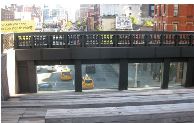
New York Highline
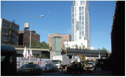
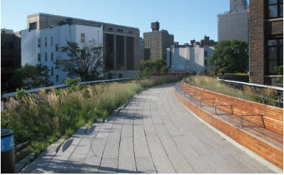

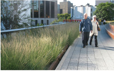
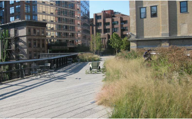
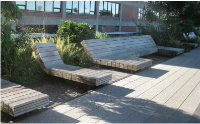
© Katie Casanta
The High Line is located on Manhattan's West Side. It runs from Gansevoort Street in the Meatpacking District to West 34th Street between 10th & 11th Avenues.
The High Line was built in the 1930s, as part of a massive public-private infrastructure project called the West Side Improvement. It lifted freight traffic 30 feet in the air, removing dangerous trains from the streets of Manhattan's largest industrial district. No trains have run on the High Line since 1980. Friends of the High Line, a community-based non-profit group, formed in 1999 when the historic structure was under threat of demolition. Friends of the High Line works in partnership with the City of New York to preserve and maintain the structure as an elevated public park.
The public space blends plant life (reminiscent of the quiet contemplative nature of the self-seeded landscape and wild plantings that once grew on the unused High Line) with long, narrow 'planks', forming a smooth, linear, virtually seamless walking surface. The public environment on the High Line contain special features, including a water feature, viewing platforms, a sundeck, and gathering areas to be used for performances, art exhibitions and educational programs.
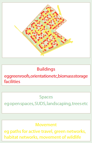
SHOWING THE DESIGN
B-plan, Bavaria In a Bavarian bebauugsplan (B-plan), design concepts are considered in terms of 3 key uses;
Buildings, Spaces and Movement. Green Infrastructure can fit into each of these, which shows how integral it is to placemaking for example:
Summary
Green Infrastructure considerations when developing a masterplan
| Distinctive |
Reinforcing the landscape character and identity |
v |
|---|---|---|
| Using unique design features |
v |
|
| Creating a sense of place |
v |
|
| Welcoming |
Including entrance and gateway features |
v |
| Making it easy to find your way around |
v |
|
| Creating places with a positive image |
v |
|
| Safe and pleasant |
Creating places with a positive image |
v |
| Addressing risks through design |
v |
|
| Delivering quality through design and maintenance |
v |
|
| Easy to move around |
Green Networks |
v |
| Connections for people |
v |
|
| Connections for wildlife |
v |
|
| Resource Efficient |
SUDS and water resource management |
v |
| Sustainable use of materials |
v |
|
| Microclimate and saving energy |
v |
|
| Renewable energy |
v |
|
| Adaptable |
Creating multi-functional open spaces |
v |
| Creating multi-functional open spaces |
v |
|
| Creating opportunities for productive landscapes |
v |
Green infrastructure should be considered integral to design, thinking about it from the outset can lead to the creation of high quality sustainable places.
There is a problem
Thanks for your feedback