Scotland's seas: towards understanding their state
Scotland's seas: towards understanding their state.
Chapter 1 Introduction and Policy Context to Scotland's Seas
INTRODUCTION
With such high-profile European legislation as the Marine Strategy Framework Directive ( MSFD) (1) being agreed in December 2007, it could be thought that assessment, monitoring and management of the marine environment is a new idea. This is far from true. A diverse range of policy has, over the years, developed incrementally the way in which the marine environment is investigated, managed and assessed. However, the tempo of marine policy development has increased rapidly in the last few years and continues to do so.
Some of these policies, both statutory and non-statutory, are the response to global and European obligations, which is appropriate given Scotland's position at the edge of Europe in the North-East Atlantic (Figure 1.1). Obligations include such global policy as the Convention on Biological Diversity (1992) (2) ( CBD) and the European Habitats (92/43/ EEC) and Birds (79/409/ EEC) Directives for the conservation of biodiversity. Also at the European level is the Water Framework Directive (2000/60/ EC; WFD). Other obligations are part of a national agenda, such as the new framework for monitoring and assessment of the UK marine environment developed after the publication of Charting Progress in 2005 (3). Annex 1 contains a list of legislation and obligations of relevance in Scotland's seas.
As mentioned already, marine monitoring is not new but today there is a renewed emphasis as a greater effort is made to understand the inter-connections between the marine ecosystems and the human activities that rely on them. With sustainability high on the agenda, it is very important that any assessment of the state of the seas, even an initial one, addresses the three pillars of the social, environmental and economic sectors. The Scottish Government's vision for the seas is for a marine environment which is:
"… clean, healthy, safe, productive and biologically diverse …… managed to meet the long-term needs of nature and people".
Figure 1.1 Scotland's position in the North-East Atlantic Ocean
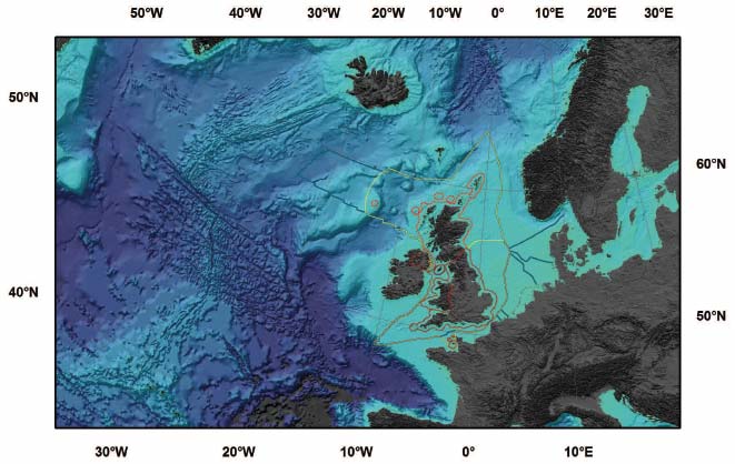
Red line = 12 nm limit; Yellow line = Scottish fisheries limits; Blue line (West of Scotland) = UK continental shelf limit.
This report has been structured around this vision, to demonstrate how this is being achieved. A full state of the seas is not presented but each element of the vision is addressed and illustrated by a range of case studies.
The report includes:
- Chapter 1 - the policy context of Scotland's seas explaining how a variety of legislation and obligations, both old and new, are driving policy and creating a context for detailed assessments.
- Chapter 2 - a description of the physical characteristics of Scotland's seas. This includes details about the features used to understand the nature of the seas and that dictate Scotland's climate and reviews some of the data about our current understanding of the seabed.
- Chapter 3 - presents an initial review of the 'Clean and Safe' status of the seas with case studies addressing such factors as the amount of hydrocarbons in seabed sediments near oil fields.
- Chapter 4 - presents an initial review of the 'Healthy and Biologically Diverse' nature of the seas with case studies on phytoplankton and zooplankton, the basis of the food chain on which all else in the seas relies.
- Chapter 5 - provides an initial review of the 'Productive' status of the seas and marine economic activity, whilst recognising some of the impacts of the various human activities described.
- Chapter 6 - assesses the effects of climate change on Scotland's marine environment.
- Chapter 7 - reviews the way ahead as preparations are made for the publication of a full State of Scotland's Seas in 2010.
- Annexes - These are on the enclosed CD and include:
- Annex 1 - Global, regional (North-East Atlantic and European) and domestic ( UK and Scottish) legislation and obligations of relevance in Scotland's seas.
- Annex 2 - Details of the various marine monitoring programmes and data collection surveys undertaken by FRS, SEPA, SNH and the wider community.
- Annex 3 - Reports on various aspects of Scotland's seas published by FRS, SEPA and SNH, as well as examples from other organisations monitoring Scotland's marine environment.
- Annex 4 - The Input-Output Approach technical note.
- Annex 5 - Data sources used to produce the information presented in case study 2.4.
- Annex 6 - Computer simulated 'fly through' of the Firth of Forth Bridges derived from multi-beam echo-sounder data.
- Annex 7 - SEPA - ADRIS Estuary Classification Scheme.
- Annex 8 - SEPA - ADRIS Coastal Water Classification Scheme.
POLICY CONTEXT
Global obligations
World Summit on Sustainable Development
The World Summit on Sustainable Development ( WSSD) took place in 2002, setting an ambitious agenda with challenging goals and targets. The UK and Scottish Governments are both committed to delivering the outcomes of the summit which, for the oceans, are to promote integrated sustainable management of oceans at all levels in order to help maintain the productivity and biodiversity of marine and coastal areas and help secure a significant reduction in biodiversity decline by 2010. These will be delivered through the:
- introduction of various policies, measures and tools such as the ecosystem approach [A] marine protected areas ( MPAs) and the incorporation of coastal interests in watershed management; and
- introduction and development of effective machinery of oceans governance and partnerships.
Regional (European and North-East Atlantic) obligation
OSPAR
In response to widespread concerns about eutrophication and increasing amounts of xenobiotic compounds reaching the seas, international agreements to protect the seas gathered pace in the 1970s. The 1972 Oslo (Convention for the Prevention of Marine Pollution by Dumping from Ships and Aircraft) and 1974 Paris (Convention for the Prevention of Marine Pollution from Land-Based Sources) Conventions formalised agreements following high-profile marine accidents. The Intergovernmental North Sea Conferences of the 1980s required contracting member states to reduce inputs of potentially polluting substances, and led to the first quantitative determination of inputs of these substances to marine waters by 1990. Requirements were rationalised in the 1992 OSPAR Convention for the Protection of the Marine Environment of the North-East Atlantic. This came into force in 1998. It requires the application by Contracting Parties (which includes the UK) of the precautionary principle, the polluter pays principle and best available techniques and best environmental practice. The requirement to determine the pollutant load to the marine environment is now embodied in the Water Framework Directive ( WFD), which has been implemented in Scotland through the Water Environment and Water Services Act 2003 ( WEWS) and subsequent Controlled Activities Regulations (2005).
A key part of OSPAR's work is its Joint Assessment and Monitoring Programme ( JAMP), which coordinates three national environmental monitoring programmes: the Coordinated Environmental Monitoring Programme ( CEMP), the Comprehensive Atmospheric Monitoring Programme ( CAMP) and the Comprehensive Study on Riverine Inputs and Direct Discharges ( RID) to provide a comprehensive monitoring framework. To meet its objective of protecting the North-East Atlantic, the OSPAR Convention has adopted several long-term strategies, with long-term aims:
- Hazardous substances
To reach concentrations equivalent to near background levels for naturally-occurring substances and close to zero for man-made synthetic substances in the marine environment by 2020. - Radioactive substances
To reach concentrations equivalent to near background values for naturally-occurring substances and close to zero for artificial radioactive substances in the marine environment by 2020. - Eutrophication
To eliminate eutrophication where it occurs in the North-East Atlantic and to prevent further occurrences. - Protection of Ecosystems and Biological Diversity
To manage human activity and support the ecosystem approach, make assessments of species and habitats and develop an ecologically coherent network of marine protected areas. - Environmental Goals and Management Mechanisms for Offshore Activities
To promote the development of goals for the oil and gas industry to prevent pollution from offshore sources, and protection and conservation of the maritime area from adverse effects of offshore activities.
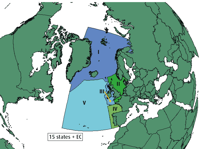
In 2000, OSPAR published the first comprehensive Quality Status Report (4) ( QSR) on the quality of the marine environment of the North-East Atlantic. This was supported by five reports on the different parts of the OSPAR maritime area - the Arctic (Region I), the Greater North Sea (Region II), the Celtic Seas (Region III), the Bay of Biscay/Golfe de Gascogne and Iberian waters (Region IV), and the Wider Atlantic (Region V) (Figure 1.2). An interim Overview of OSPAR Assessments 1998 - 2006 (5) was published in 2006 with an updated QSR due to be published in 2010; Scottish scientists are involved in the preparation of QSR 2010.
Figure 1.2 OSPAR regions
European Integrated Maritime Policy
In October 2007 the European Commission announced its vision for an integrated maritime policy for the EU(6). This emphasised the need for joined-up decision making to deliver economic growth and included a detailed action plan (7) and work programme. It has a number of elements, including:
- maximising the sustainable use of the oceans and seas; due to the importance of shipping and ports, a comprehensive maritime transport strategy and new ports policy will be prepared;
- building a knowledge and innovation base for maritime policy, including developing a European Strategy for Marine Research;
- creating a European network for integrated surveillance, including a European Marine Observation and Data Network; and
- delivering the highest quality of life in coastal regions; this will promote tourism to assist outermost regions and islands and develop a strategy to mitigate the effects of climate change on coastal regions.
The integrated maritime policy aims to deliver a sustainable development approach for Europe's oceans and seas with the recent MSFD providing the environmental pillar of the sustainable development approach.
European Marine Strategy Framework Directive
In December 2007 the European Parliament agreed the text for the MSFD, the latest marine legal obligation. Endorsement by the Council of Ministers is expected in early 2008 with formal completion of the Directive soon after. This Directive will effectively extend many of the provisions of the European Water Framework Directive ( WFD) to seas beyond the current WFD limits. The Directive splits European seas into a number of areas. Scotland is mainly within the Greater North Sea ( OSPAR region II) and the Celtic Seas ( OSPAR region III). These regions are significantly larger that the WFD coastal water bodies. The Directive requires Member States to "take the necessary measures to achieve or maintain good environmental status in the marine environment by the year 2020 at the latest." The steps necessary to do this are similar to those required under the WFD:
An initial assessment is required to determine the current environmental status of the waters and the environmental impact of human activities; this is to be completed by 2012. Based on the initial assessment, and also by 2012, what constitutes good environmental status ( GES) has to be determined and environmental targets and indicators established. Then, by 2014, a monitoring programme has to be implemented. This is followed, in 2015, by the development of programmes of measures, essentially management actions, to ensure that human activity is managed in such a way that GES is achieved. These must come into force by 2016. The whole process, a national marine strategy, is cyclical with regular reporting to the Commission. It also provides a legal basis for the ecosystem-based approach to marine management.
Table 1.1 Comparison of the UK and Scottish Visions with the MSFD definition of GES
MSFD Definition of GES |
Vision statement in "Safeguarding our Seas" (8) and "Seas the Opportunity" (10) |
|---|---|
"good environmental status" means the environmental status of marine waters where these provide ecologically diverse and dynamic oceans and seas which are clean, healthy and productive within their intrinsic conditions, and the use of the marine environment is at a level that is sustainable, thus safeguarding the potential for uses and activities by current and future generations, i.e.: (a) the structure, functions and processes of the constituent marine ecosystems, together with the associated physiographic, geographic, geological and climatic factors, allow those ecosystems to function fully and to maintain their resilience to human-induced environmental change. Marine species and habitats are protected, human-induced decline of biodiversity is prevented and diverse biological components function in balance; (b) hydro-morphological, physical and chemical properties of the ecosystems, including those properties which result from human activities in the area concerned, support the ecosystems as described above. Anthropogenic inputs of substances and energy, including noise, into the marine environment do not cause pollution effects |
To shape the UK's capability, within National and International waters, to: "Provide, and respond, within a changing climate, to the evidence required for sustainable development within a clean, healthy, safe, productive and biologically diverse marine ecosystem and within one generation to make a real difference." In Scotland, "to secure a vision of clean, healthy, safe, productive and biologically diverse marine and coastal environments managed to meet the long-term needs of nature and people." |
The MSFD does not define productive. In the Safeguarding Our Seas context productive relates to economic use of the seas and this is the context in which the term is used in this report.
Under the terms of the MSFD the OSPAR Regional Seas Convention is promoted as the mechanism by which Member States cooperate to achieve good environmental status by 2020.
The MSFD helpfully includes a definition of GES. This has similarities to the WFD's definition of good ecological status ( GEcS) for coastal waters and the UK's vision for our seas (see Table 1.1). Annex I of the MSFD also details a number of qualitative descriptors that will be used for determining GES. Table 1.2 lists the descriptors and sets out parameters that are measured to show the status of the seas together with references to chapters of this report where initial data about that descriptor may be found. The characteristics, pressures and impacts on the marine environment that are to be considered are also stated in Annex IIIof the MSFD. Table 1.3 lists these, together with initial examples of where such characteristics, pressures and impacts are discussed in this report. Policy makers need to work with scientists, and the wider marine community, to establish how GES of Scottish waters will be measured, based on these characteristics, pressures, impacts, descriptors and the overall definition of GES. It is anticipated that a clearer picture will be available for the State of Scotland's Seas report in 2010.
Table 1.2 MSFD qualitative descriptors for determining GES
Descriptors |
Chapter of this report where |
|---|---|
(1) Biological diversity is maintained. The quality and occurrence of habitats and the distribution and abundance of species are in line with prevailing physiographic, geographic and climatic conditions |
|
(2) Non-indigenous species introduced by human activities are at levels that do not adversely alter the ecosystems |
|
(3) Populations of all commercially exploited fish and shellfish are within safe biological limits, exhibiting a population age and size distribution that is indicative of a healthy stock |
|
(4) All elements of the marine food webs, to the extent that they are known, occur at normal abundance and diversity and levels capable of ensuring the long-term abundance of the species and the retention of their full reproductive capacity |
|
(5) Human-induced eutrophication is minimised, especially adverse effects thereof, such as losses in biodiversity, ecosystem degradation, harmful algal blooms and oxygen deficiency in bottom waters |
|
(6) Sea floor integrity is at a level that ensures that the structure and functions of the ecosystems are safeguarded and benthic ecosystems, in particular, are not adversely affected |
|
(7) Permanent alteration of hydrographical conditions does not adversely affect marine ecosystems |
|
(8) Concentrations of contaminants are at levels not giving rise to pollution effects |
|
(9) Contaminants in fish and other seafood for human consumption do not exceed levels established by Community legislation or other relevant standards |
|
(10) Properties and quantities of marine litter do not cause harm to the coastal and marine environment |
|
(11) Introduction of energy, including underwater noise, is at levels that do not adversely affect the marine environment |
Table 1.3 Indicative list of characteristics, pressures and impacts in Annex III of the MSFD
Characteristics |
Chapter of this report where |
|---|---|
Physical and chemical features |
|
Habitat types |
|
Biological features |
|
Other features (e.g. chemicals and specific characteristics) |
|
Pressures and Impacts |
|
Physical loss |
|
Physical damage |
|
Other physical disturbance |
|
Interference with […] hydrological processes |
|
Contamination by hazardous substances |
|
Systematic and/or intentional release of substances |
|
Nutrient and organic matter enrichment |
|
Biological disturbance |
|
Water Framework Directive
The Water Framework Directive (2000/60/ EC; WFD) is a wide-ranging piece of European environmental legislation which became law in Scotland at the end of 2003 through the Water Environment and Water Services (Scotland) Act 2003 ( WEWS Act). The Directive establishes a new legal framework for the protection, improvement and sustainable use of surface waters, transitional waters, coastal waters and groundwater across Europe in order to prevent deterioration, enhance status of aquatic ecosystems, including groundwater and reduce pollution. The Directive repeals and replaces a number of older directives and incorporates the remaining existing water Directives (the Bathing Water, Nitrates and Urban Waste Water Treatment Directives) into its framework through its protected areas provisions. Classification systems that the directive requires are outlined in a case study in Chapter 3. The language, the sequential steps and the drive to good ecological status of the WDF are very similar to those in the MSFD although there are some key differences, namely:
1) WFD is already in place so the timetable is much tighter. Monitoring has started and the first River Basin Management Plan has to be ready for 2009 which will define the Environmental Objectives and programme of measures. A further plan has to be produced by 2013 with the aim of achieving good surface water status by 2015. The cycle then starts again over 6 year periods.
2) The spatial scale of the WFD only covers inshore coastal waters and transitional (brackish waters and estuaries) out to three nautical miles from the Scottish Baseline. This does, however, include large sea areas such as the Sea of the Hebrides, the Minch, the Clyde and other major Firths.
3) Crucially, the WFD brings in holistic regulations and monitoring programmes that cover the land/sea interface and as most of the contamination that enters the sea emanates from land, control at this point is at its most effective.
An important part of the WFD implementation is international inter-calibration work to ensure that the good ecological status quality boundary is equivalently defined and implemented by all member states. Similar work is anticipated under the MSFD.
European Habitats and Birds Directives
The EC Habitats and Birds Directives require the UK to identify and designate two types of area: Special Areas of Conservation ( SAC), where they support rare, endangered or vulnerable natural habitats and species of plants and animals (other than birds) as listed in Annexes 1 and 2 of the Habitats Directive, and Special Protection Areas ( SPA) that support significant numbers of wild birds and their habitats as listed in the Birds Directive. The requirements of these Directives extend out to the 200 nm limit. The collection of sites, known as the Natura 2000 network, is designed to ensure the continued survival of important habitats and species but also encourages the sustainable management of the marine environment as a whole. The continuing challenge in meeting the objectives of the Directives is to work with all those who use and manage the marine environment to allow wildlife to thrive and people to work and enjoy recreation in harmony with the natural heritage.
Domestic ( UK and Scottish) obligations
In 2002, the UK developed a strategy for the conservation and sustainable development of our marine environment, Safeguarding our Seas(8). This introduced a vision for a marine environment which is clean, healthy, safe, productive and biologically diverse . The principles of sustainable development, integrated management, conservation of biological diversity, robust science, precautionary principle and stakeholder involvement were identified to underpin policy for the marine environment. This strategy also committed the UK to an integrated assessment of the seas.
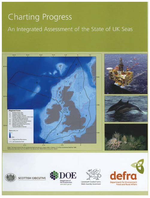
Charting Progress
Charting Progress - An Integrated Assessment of the State of UK Seas(3) (Figure 1.3) was published in March 2005. This was the first integrated assessment undertaken across the whole of the UK continental shelf and was based on four peer-reviewed sector reports and an integrated regional assessment based on eight regional areas.
In overview, it concluded:
"The general picture that emerges from the evidence is mixed. The UK seas are productive and support a wide range of fish, mammals, seabirds and other marine life. The open seas are generally not affected by pollution and the levels of monitored contaminants have decreased significantly. The main contamination problems which are identified are in part due to the legacy of the past and are generally observed at higher levels in industrialised estuaries or areas local to the activity.
However, human activity has already resulted in adverse changes to marine life and continues to do so. For example, widespread commercial fishing practices threaten many fish stocks by over-exploitation and damage sea floor areas. There is also evidence that the marine ecosystem is being altered by climate change: for example sea temperatures are rising and the distribution of plankton species is changing. These changes pose a real threat to the balance and integrity of the marine ecosystem."
Figure 1.3 Charting Progress
In addition, a number of lessons learned from the process of compiling Charting Progress were identified and a number of recommendations made. The key ones of relevance here were the need to:
- develop marine ecosystem indicators;
- evaluate and revise current marine monitoring programmes; and
- capture knowledge, not just data, and also improve our data and information stewardship.
It is remarkable to note that at the time of Charting Progress being prepared there was not a central record of who monitored what, where, when and why for the marine environment and there was no overall coordination of the many programmes.
Figure 1.4 UKMMAS logo
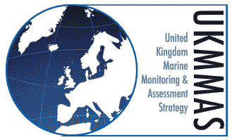
The main mechanism through which the recommendations from Charting Progress are being taken forward is the UK Marine Monitoring and Assessment Strategy ( UKMMAS) (Figure 1.4). This is co-chaired by the Scottish Government and Defra and is implementing an improved way of managing the marine monitoring programmes, assessment activity and is working towards better stewardship of the collected data.
The UKMMAS strategy became part of core business for monitoring organisations in January 2008. The structure of the mechanism is shown in Figure 1.5. A high-level policy committee ( MAPC) steers the strategy, whilst a technical committee ( MARG) oversees the work of various sub-groups which themselves address the activities of data gathering to demonstrate the vision is being met. These include three evidence collection groups (the Clean and Safe Seas Evidence Group ( CSSEG); Healthy and Biologically Diverse Seas Evidence Group ( HBDSEG) and Productive Seas Evidence Group ( PSEG)) and sub-groups with responsibility for the production of integrated assessments, data stewardship and monitoring protocols.
One of the collaborative monitoring programmes set up through MARG, the UK Clean and Safe seas Environmental Monitoring Programme ( CSEMP), overseen by CSSEG, is long-term and was built on, and continues building on, the datasets from earlier programmes such as the UK National Marine Monitoring Programme (9). It is also now a significant part of the monitoring network required by the WFD.
Devolution
In 1999, the UK Parliament devolved certain powers to Scotland. Since then, the responsibility for marine activities has been split between Holyrood and Westminster. Table 1.4 sets out the broad responsibilities.
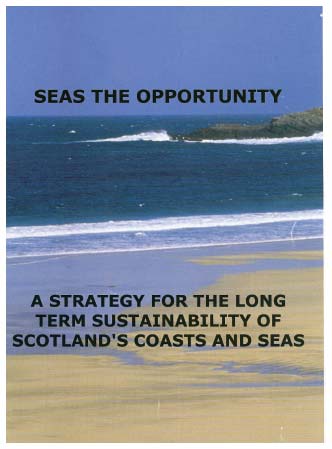
To further develop Scottish marine and coastal policy in a devolved context, Seas the Opportunity - a strategy for the long term sustainability of Scotland's coasts and seas(10) (Figure 1.6) was published in 2005. This endorsed the vision for "clean, healthy, safe, productive and biologically diverse marine and coastal environments, managed to meet the long term needs of nature and people" . The strategy set out an objective to "develop better integrated, relevant scientific data on the marine environment and the effects of pressures on it". This current report is a part of that process. A key action of Seas the Opportunity was to establish the Advisory Group on Marine and Coastal Strategy ( AGMACS), a Ministerially chaired group to further the development of marine and coastal policy work by involving stakeholders.
Figure 1.5 UKMMAS Structure
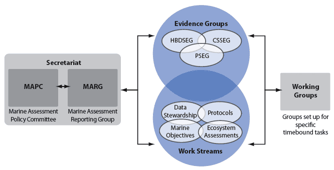
Table 1.4 Devolved and reserved responsibilities for key marine activities
Activity |
Within 12 nautical miles |
12 to 200 nautical miles |
|---|---|---|
Fishing |
Devolved |
Devolved |
Aquaculture |
Devolved |
Not applicable |
Nature and conservation |
Devolved |
Reserved |
Harbours & harbour orders |
Devolved |
Not applicable |
Control of land-based discharges ( WEWS Act) |
Devolved |
Not applicable |
Planning |
Devolved |
Reserved |
Coast Protection Act |
Devolved |
Not applicable |
FEPA |
Devolved |
Executively devolved |
Renewable energy |
Executively devolved |
Executively devolved |
Telecommunications |
Reserved |
Reserved |
Oil and gas |
Reserved |
Reserved |
Shipping |
Reserved |
Reserved |
Historic heritage |
Devolved |
Reserved |
Executively devolved - Scottish Government administers the activity but has no powers to change the legislation.
Figure 1.6 Seas the Opportunity
In 2007, reports by both AGMACS(11) and the Scottish Parliament Environment and Rural Development Committee (E& RDC), the latter having started an Inquiry into the Marine Environment(12), were published. In terms of marine science and data, the common themes to their recommendations were the need to:
- develop performance indicators;
- prioritise measures to bring available marine data together;
- support Scottish input to marine data archive centres;
- document current marine research and identify process for prioritising new research; and
- undertake research on the science of indicators and the impact of different activities on the marine environment.
Developing Scotland's Seas: Towards Understanding their State is a key first step to taking forward the recommendations from AGMACS and the E& RDC as well as establishing a baseline against which future marine and coastal policy can be measured.
New marine legislation in UK and Scotland
Following a commitment by the Prime Minister in 2001, the UK Government has been developing new marine legislation. The UK Marine Bill White Paper was published in March 2007 and includes proposals for a new marine management organisation, marine planning, licensing of marine activities, marine nature conservation and managing of inshore fisheries around England and Wales. A draft Bill is expected in spring 2008.
In June 2007 the Scottish Government announced its intention to bring forward legislation for Scotland's marine environment and in its Programme for Government committed to consult on proposed marine legislation. Since January 2008, a Sustainable Seas Task Force, with a membership from the wide marine stakeholder community, has been contributing to the development of a consultation paper for the intended marine legislation. The consultation is expected later in 2008 and is likely to include proposals to cover marine planning, marine nature conservation, streamlined licensing and, possibly, proposals for a marine management organisation. The intended legislation seems to fit with the wider recommendations of both AGMACS and the E& RDC.
Why this report "towards understanding the state of Scotland's seas"?
The quantity of marine policy is, in itself, insufficient to demonstrate the effectiveness of marine legislation to achieve the overall vision of "clean, healthy, safe, productive and biologically diverse seas". To demonstrate that the vision is being achieved needs: (a) a definition of the state according to some assessment criteria (i.e. what is a healthy sea?), and (b) determination of indicators to measure Scotland's seas against targets, using these to highlight gaps in knowledge. Some would argue that the process should be reversed, using a suite of indicators to define the vision. In practice the vision for clean, healthy, safe, productive and biologically diverse seas needs to be merged with pragmatic metrics of all these requirements. To understand the seas, assessments are needed but these take time. To assist with the current Scottish marine policy development, this report provides a baseline of information and data sources that paves the way for a full State of Scotland's Seas report in 2010.
Two initiatives being undertaken through the UKMMAS process will provide valuable tools for Scottish marine policy makers and managers.
- The UK Database of Marine Observing Systems ( UKDMOS) will, for the first time, provide a web based portal of who in the UK does what, where, when and why in the marine environment. The database can be found at www.ukdmos.org; and
- Contributory Marine Objectives ( CMOs), currently being developed by the three UKMMAS Evidence Collection Groups, will provide statements which will facilitate in the description of clean and safe, healthy and biologically diverse and productive seas. These CMOs will be described by an underlying set of indicators.
This report will contribute to the debate on clean and safe, healthy and biologically diverse and productive seas whilst adopting, where appropriate, thresholds enshrined in legal and other obligations. In addition, Annex 2 summarises the Scottish monitoring programmes listed in UKDMOS.
Who does marine monitoring and research in Scotland's seas?
Understanding the state of the complex environment of Scotland's seas requires information to be integrated from a range of disciplines, from atomic through the microbial to the ecosystem level. Many specialists have provided the evidence to support policy decisions and assess the state of the seas. Annex 2 outlines the data that are being collected by FRS, SEPA and SNH from Scotland's seas and some of the data collecting programmes conducted by the wider community. These are briefly summarised, where appropriate, in Chapters 2-6.
Annex 3 is a list of reports from FRS, SEPA and SNH that report on the state of Scotland's seas according to the Scottish vision of "clean, healthy, safe productive and biologically diverse seas". To provide a comprehensive list of reports published by the wider community on the aspects of the Scottish vision would run into hundreds of pages, and so Annex 3 also gives examples of existing reports with evidence on the state of Scotland's seas to illustrate the types of publication available from the wider community.
Indicators
Indicators are representative, concise and easy-to-interpret variables which are used to illustrate the main features of the marine environment. Thus indicators reflect trends in the state of the marine environment and monitor the progress made in realising policy targets. The International Council for the Exploration of the Seas ( ICES) has defined the criteria for a 'good indicator' specifically in relation to Ecological Quality Objectives, and these are presented in Table 1.5.
Table 1.5 Criteria for a 'good indicator' specifically in relation to Ecological Quality Objectives as defined by ICES
Criterion |
Property |
|---|---|
a |
Relatively easy to understand by non-scientists and those who will decide on their use |
b |
Sensitive to a manageable human activity |
c |
Relatively tightly linked in time to that activity |
d |
Easily and accurately measured, with a low error rate |
e |
Responsive primarily to a human activity, with low responsiveness to other causes of change |
f |
Measurable over a large proportion of the area to which the [EcoQ] metric is to apply |
g |
Based on an existing body or time series of data to allow a realistic setting of objectives |
Indicators have become indispensable to policy-makers. They summarise large amounts of data and may relate to trends in pressures, state or impacts. In relation to our vision for "clean, healthy, safe, productive and biologically diverse seas", indicators can be used for three major purposes:
- to supply information on the state of Scotland's seas, in order to enable policy-makers to develop policy and assess any emerging environmental problems;
- to support priority setting, by identifying key factors and gaps in knowledge that cause pressure on the marine environment; and
- to monitor the effects of policy responses.
As shown in Table 1.5, data for indicators must be collected at appropriate spatial, temporal and ecological (i.e. individuals versus communities) scales, with replication for robustness and a measure of quality assurance. Collecting data for indicators can be very resource intensive and consequently baseline data, against which the current state should be assessed, for some species and habitats have not (yet) been collected. A relatively good knowledge of plankton, some fish, bird and marine mammal species and some habitats exists, however, indicators have still to be developed for the less charismatic components of the marine realm including, for example, microbes, the deep sea, benthos, food-web interactions and ecosystem function.
In order for sustainable management to be effective it is important to understand the relationship between the ecological response (e.g. chlorophyll concentration) and the pressure (e.g. climate change). As an example, a decline in seal numbers could result from anthropogenic (e.g. shooting) or natural (e.g. disease outbreak) pressures. Both natural and anthropogenic change may have management consequences, yet indicators will rarely differentiate between these different impacts. The Pressure-State-Response ( PSR) framework can be used, alongside policy questions, to develop a set of indicators. This approach can be considered as a tool for organising and presenting information to decision-makers; it shows the links between the causes of environmental problems and society's responses to them. For example:
- Pressures on the environment e.g. exploitation of renewable and non-renewable resources, pollution inputs including waste, conflict of interest in use of marine space, invasive/non-native species. The pressures on the environment are often considered from a policy perspective as the starting point for tackling environmental issues, and, from an indicator viewpoint when they are perhaps more readily available for analysis since they can be derived from socio-economic, environmental and other monitoring databases.
- State of the environment resulting from above pressures, including physical, chemical, biological and socio-economic. The state of the environment may, in turn, affect human health and well-being as well as the socio-economic fabric of society. Indicators of state should be designed to be responsive to the pressures and at the same time facilitate decisions on corrective action.
- Response of society to prevent negative environmental impacts, to correct existing damage, or to conserve natural resources e.g. designation of protected areas. Responses should be designed to act on the pressures but may at the same time also have an impact modifying the indicators of state.
Reporting areas
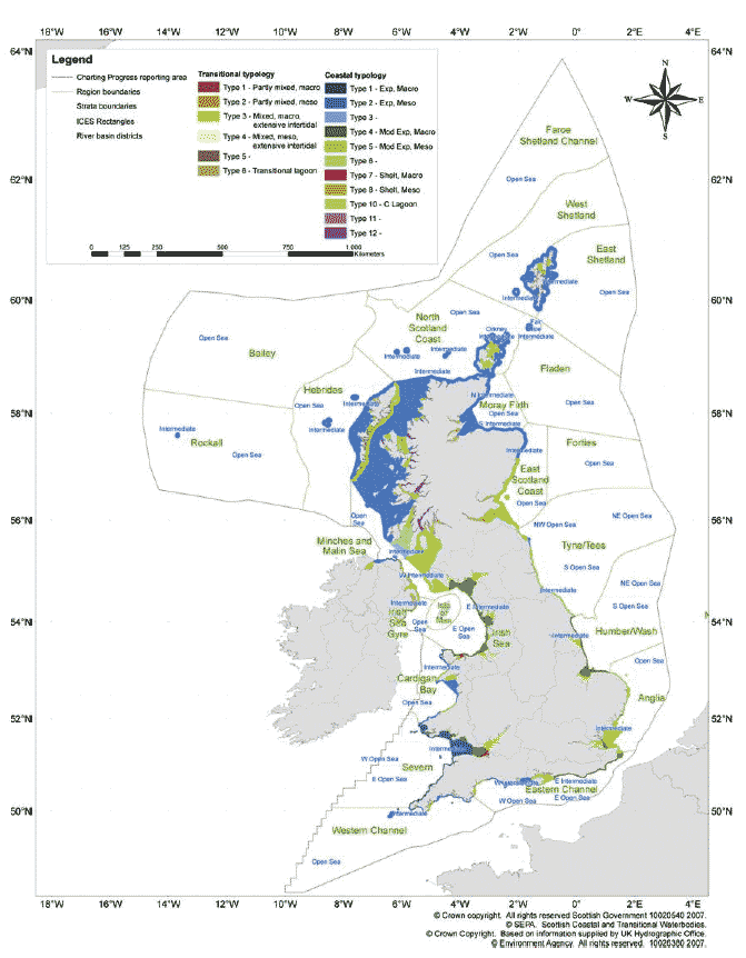
As part of the UKMMAS process, and in preparation for Charting Progress 2, new reporting areas have been developed. These are shown in Figure 1.7. Where possible, the Summary Assessments used in this report, and where differing geographical analyses are possible, have adopted these areas.
Figure 1.7 Sea areas adopted in this report
Summary Assessment
As part of the process of establishing the status of the marine environment, summary assessments are included throughout this report and, more specifically, as part of the various Case Studies presented to highlight, in more detail, aspects of the science being conducted within Scottish waters. To maintain consistency, the summary assessment used in the UK Charting Progress process has been adopted here. One new column, for geographical region, has been added (Table 1.6). The key to the 'trend assessment', 'status' and 'confidence' are presented in Tables 1.7, 1.8 and 1.9 respectively. These summary assessments present the current status for the specific regions detailed for that assessment and will be further developed in the State of Scotland's Seas to be published in 2010. In Chapter 5, summary assessments are also presented, where possible, on the basis of the available production statistics.
Table 1.6 An example of the Summary Assessments used in this report
Parameter |
Geographical region |
Key factors & |
What the |
Trend |
Status now |
Confidence |
Reason for |
|---|---|---|---|---|---|---|---|
Sediment |
Fladen and |
Offshore oil and |
Reduction in |
|
III |
Sufficient |
Table 1.7 Key to Assessment Table - Trends
|
Measurement shows improvement |
|
Deterioration |
No change or variable trend shown |
|
|
No trend available or implications not understood |
Table 1.8 Key to Assessment Table - Assessment of Status
Unacceptable |
|
Room for improvement |
|
Acceptable |
Table 1.9 Key to Assessment Table - Confidence of Assessment
III |
High |
II |
Good/Satisfactory |
I |
Low |
0 |
No assessment possible |
CONCLUSION
Scotland's marine environment is of fundamental importance to the country. It influences weather patterns and provides many resources. However, this biologically diverse environment is under pressure from many human activities which, either individually or combined, have the potential to permanently alter the fundamental ecosystem processes. In some cases this may already have happened. It is necessary to ensure that the appropriate scientific information is collected and analysed so as to provide the required advice which will ensure that Scotland's marine environment is used in a sustainable manner or that impact of the damage that has already occurred is reduced or reversed. The following chapters provide information on both our current knowledge of the marine environment and the on-going scientific monitoring which will form the basis of our integrated assessment of the State of Scotland's Seas to be published in 2010.
Contact
Email: Central Enquiries Unit ceu@gov.scot
There is a problem
Thanks for your feedback